Agricultural sciences scientific basis for fight against Eyeir Eyesium of Namangan Adyrov in the Republic of Uzbekistan

Author: Dadakhodjaev A., Mamadjonov M., Ergashev M.
Journal: Теория и практика современной науки @modern-j
Section: Основной раздел
Article in issue: 2 (44), 2019.
Free access
Mapping of ravine erosion in complex landscape conditions in the world practice of erosion, linear forms of ravine erosion are usually mapped by decoding aero-cosmophotographs (APS-KFS), as well as traditional mapping methods - using topographic maps.
Gully erosion of decoding, aerial photograph, aerial cosmic photograph, photographic lines, topographic maps, scale
Short address: https://sciup.org/140289521
IDR: 140289521
Сельскохозяйственные науки научная основа борьбы с глазами Намангана Адырова в Республике Узбекистан
Картирование овражной эрозии сложных ландшафтно условыях в мировим практике эрозиоведения линейние формы овражной эрозии принято картографировать путем дешифриревания аэро-космофотоснимков (АФС-КФС), а также традиционных методов картографирования - с помощью топографических карт.
Text of the scientific article Agricultural sciences scientific basis for fight against Eyeir Eyesium of Namangan Adyrov in the Republic of Uzbekistan
Namangan adyri are located in the north - eastern part of Namangan region. As is known, the main criterion in the fight against gully erosion is the one-time introduction of anti-gully measures across the entire stockpiling surface, i.e.
completeness in the implementation of organizational - economic, forest - agro -hydromeliorative activities [1].
In the ravaged territories of Namangan Adyr, from the organizational and economic measures into the practice of the agro-industrial complex, we introduced a system of soil conservation agriculture: two-time annual accounting and assessment of diffuse land on farms, districts, and the application of administrative and legal liability to offenders; certification, licensing and certification of land allotments for businesses and individuals; implementation of land use schemes and projects according to our recommendations (Nigmatov, Dadahodzhaev et al., 1994), as well as development by the Uzgiprzema Institute, allocation of ravine lands by category and priority of development, as well as phasing of land reclamation [2].
The table below shows a general description of the location of the ravines of
Namangan Adyr [3].
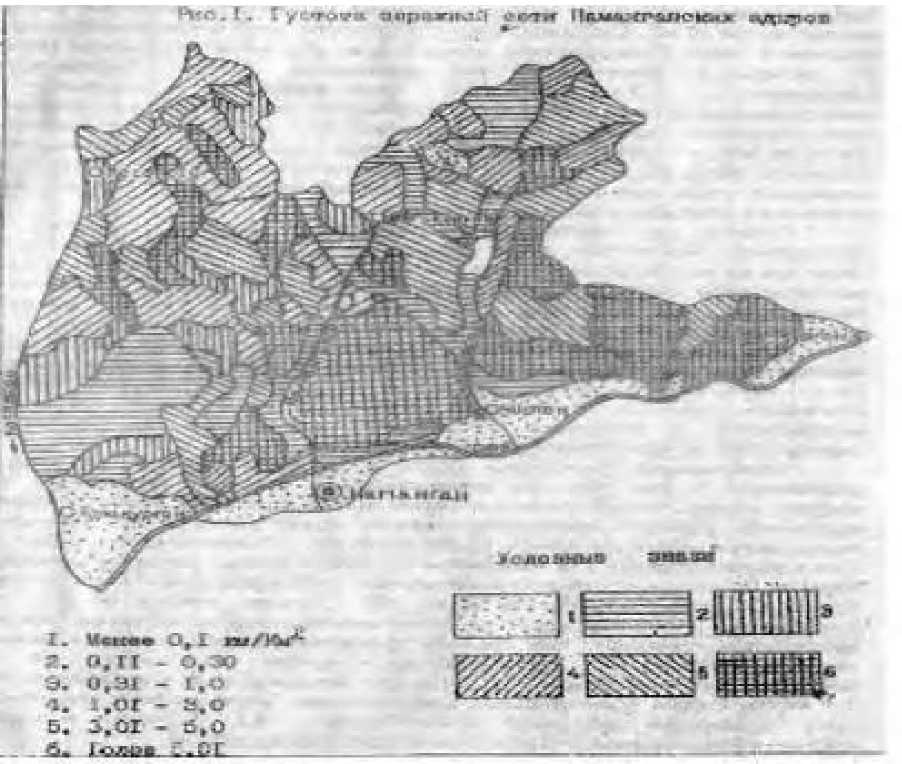
Table 1
|
№ |
Densit y PC/ sq.km. |
Square |
Densit y Sq / km |
Square |
Frequenc y, m |
Power contagiousne ss |
||
|
Thousan d ha |
% |
Thousan d ha |
% |
|||||
|
1 |
Less 0,1 |
9,5 |
8,3 |
Менее 0,1 |
9,4 |
8,2 |
More 1000 |
Nonfermented |
|
2 |
0,11 0,60 |
17,7 |
15,5 |
0,11 0,30 |
16,5 |
14, 5 |
1000-501 |
Slightly contaminate d |
|
3 |
0,61 - 1,5 |
12,9 |
11, 3 |
0,31 -1,0 |
8,6 |
7,6 |
500-201 |
Animized |
|
4 |
1,51 -5,0 |
21,8 |
19, 1 |
1,01 3,0 |
22,1 |
19,4 |
200-101 |
Average |
|
5 |
5,01 10,0 |
17,9 |
15, 7 |
3,01-5 |
20,5 |
17, 9 |
100-51 |
Heavily contaminate d |
|
6 |
More 10.01 |
34,2 |
30, 1 |
More 5,01 |
36,9 |
32, 4 |
Less 51 |
Very much contaminate d |
On the contaminated lands of heaps, the most accessible and equally effective anti-vegetation measure was the agromeliorative technique [4]. Field route studies have shown that with the introduction of conservation agriculture, the contagiousness of the territory decreases sharply. For example, the agricultural company "Bobir" consistent band placement of crops on Bogar, even with a slope of more than 15 degrees, the ravine dissection drops to 0.1 sq / km. The width of the strip did not exceed Hume, where the sequence of crop placement was structured according to the scheme: winter wheat — a perennial grass — an annual grass, where the place for growing perennial grasses should be located at the foot of the slope. On irrigated lands, the safest anti-crop agrotechnical measures in farms in the “Fergana” section of the Muchumskiy kishchny council of the Chartak district were planting perennial sprouts and drip irrigation. Weakly contaminated adyr slopes are occupied with perennial grasses and continuous grain sowing [5]. Forest melioration measures to combat gully erosion were investigated on the abyrs of the Chartak district of Namangan region in accordance with the guidelines and recommendations developed by the Institute of Soil Science and Agrochemistry of the State Committee Ergeodez cadastre of the Republic of Uzbekistan. Hydro-reclamation techniques had the most protivovrazhnym effect: terracing on slopes with a slope of 15 degrees, watering on the smallest slope with preliminary soil moistening before the main irrigation.
References Agricultural sciences scientific basis for fight against Eyeir Eyesium of Namangan Adyrov in the Republic of Uzbekistan
- Nigmatov, AN, Dadahodzhaev, A. Adirlarda, jarlanisha va ularni tubdan, meleoration of the kilish. Toshkent 1997.
- Nigmatov A.N., Dadahodzhaev A., Lyubimov B.P. Recommendations for assessment, mapping and ejection of ravine and technogenic outdated lands. 1994 IPAAN. R.Uz. 1994
- Dadahodzhaev A, Mamazhanov MM, Khaidarov S.E. Mapping the manifestations of growth and development of ravines on the density and density of adyr of the Republic of Uzbekistan, Saratov "Collection of articles of the International Scientific and Practical Conference". February 13, 2016, pages 4-7
- Dadahodjaev A. Akhmedov B. "Tuproi erosion of va unta karshi kurash choralari. FerPI Scientific Technical Journal 2013 number 3
- Dadahodzhaev A Ba Boskalar. "Adirlarda hotarns usunpigi vazichligi buyich tarkdlishi" FerPI Scientific Technical Journal 2015 №2
