Air photography with use of unmanned aerial vehicle for solution of agriculture and cadastre tasks

Author: Sutugina I.M., Mamin R.G.
Journal: Вестник аграрной науки @vestnikogau
Article in issue: 3 (42), 2013.
Free access
Issues of information provision for agriculture and cadastre according to air photography materials from unmanned aerial vehicle are considered in the article. Materials of experimental air photography from air plane and copter were used. The work suggests technology of executing works on photography and processing of materials. Air photography parameters were proposed according to image quality and requirements for ground images resolutions for solving tasks of cadastre and agriculture.
Information, cadastre, air photography, unmanned aerial vehicle, unmanned airplane, copter, air photography parameters, work execution technology
Short address: https://sciup.org/147124079
IDR: 147124079 | UDC: 528.7(203):629.73:63
Text of the scientific article Air photography with use of unmanned aerial vehicle for solution of agriculture and cadastre tasks
Effective and efficient use of land resources is an urgent problem of our time. Acquisition of material values, providing people with food and shelter, allocation of industrial enterprises, social, cultural, communal and other institutions are related with land resources. Territorial documentation of the organizational structure of agriculture sector and its subdivisions shall be performed in the land management system. The economic essence of the land management as a public measure changes and expands, but precision of engineering geodetic base and its conducting remain unchanging. With the help of the main ways of use the results of geodetic, air photography geodetic and other surveys and studies, both in industry and in agriculture the land development projects are drawn up.
The use of electronic maps for precision farming helps to save energy costs for technical operations, to reduce the amount of fertilizer. The use of soil electronic maps allows you to place agricultural crops with due account for land suitability. The use of agrochemical electronic maps allows you to define the need for application of mineral and organic fertilizers. The [1] and [3] shows in detail the theoretical foundations of the traditional plan and map providing of agriculture and cadastre.
The present work is devoted to plan and map providing of agriculture and real estate cadastre with air photography materials obtained with use of an unmanned aerial vehicle (hereinafter - UAV) by the example of the shooting of urban area and irrigation apparatus «Frigat», located in the city of Engels, Saratov region.
Unmanned aerial vehicles (UAVs) are used in different countries for air photography for military and civilian purposes, as an inexpensive alternative to traditional satellite imagery and air photography from airplanes, helicopters, moto-deltaplan, aerostats [2].
The advantages of air photography from unmanned aircrafts over space and traditional air photography are the following: low-level photography (from 10 to 500 meters); high ground resolution; the ability to photo at an angle to the horizon (oblique photography); the ability to make panoramic photos; efficiency: the total cycle starting from departure to the site for shooting until the final results is a few hours; low cost: it is cheaper than traditional methods of air photography for several times (up to 10); the work in urban conditions is possible; complicated procedure of permits obtaining and flights coordination is not required.
There are some hinders of UAV market development. Currently, the development of civil UAV market, including for needs of air photography, hampered by the absence of the legal framework for the integration of UAVs in a common airspace. This problem is not completely solved in any country of the world. Russia is taking the first steps in this direction. For now, before creation of the legal framework, unmanned systems are purchased by the entities with special authority (border guards, police, emergency). Currently, legal launching of UAV for commercial purposes is subject to the authorization obtained as per procedure tried and tested by UAV supplier companies. Provided that the responsibility for the flight is imposed on the operator who controls the start-up.
Currently UAVs are not supplied with the system of recognition of obstacles and avoiding of collisions, in addition, many models have not quite perfect autopilot (to reduce the costs and reduce the weight of aircraft equipment). The risk of loss of the aircraft and equipment leads to the fact that many companies may choose not to buy UAVs and buy the flight hours in organizations that have specialized in unmanned launches.
Despite these abovementioned constraints the development of air photography with use of UAVs is perspective enough for agriculture and cadastre. To perform the research we selected air photographs of the settlement “Privolzhsky” and fields with "Frigat” irrigation apparatus installed therein (Figure 1).
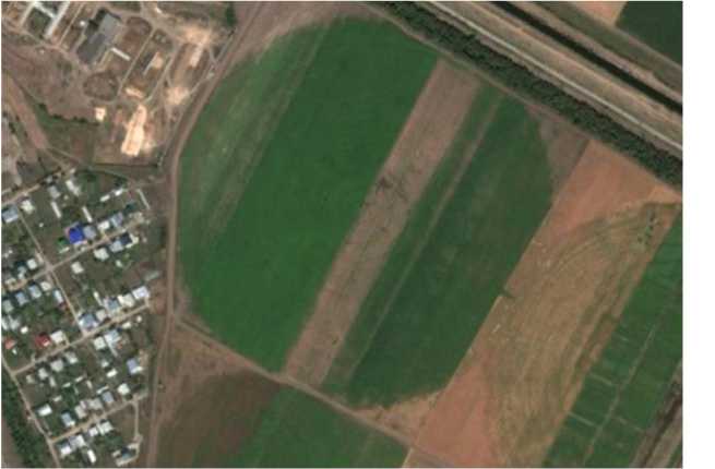
Figure 1 – Part of the settlement «Privolzhsky» and fields with «Frigat» irrigation apparatus installed therein
Air photography was performed with two unmanned vehicles (plane and copter) using three digital cameras Canon PowerShot A490, Sony Cyber-shot DSC-W300 and the Pentax Optio A40. Figure 2 shows fragments of pictures obtained.
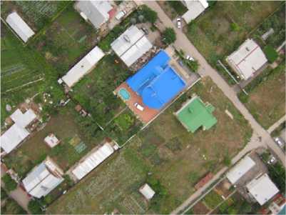
(a) Fragment of the settlement
Figure 2 – Examples of fragments of images used for experimental work (a, b)
(b) Fragment of «Frigat» irrigation apparatus
Cameras’ parameters are shown in Table 1. In technical terms the process air photography with use of UAVs consists of three stages: preparation, the survey and postprocessing of obtained data.
Table 1 – Some parameters of cameras
|
Full name |
Canon PowerShot A490 |
Sony Cybershot DSC-W300 |
Pentax Optio A40 |
|
Effective resolution, millions of pixels |
10 |
13.6 |
12 |
|
The minimum focal length (mm) |
6.6 |
7.6 |
7.9 |
|
The maximal focal length (mm) |
21.6 |
22.8 |
23.7 |
With regard to the technology of air photography from UAV we proposed a flow diagram of maps and plans printing with use of this type of air photographs (Figure 3).
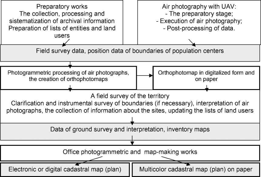
Figure 3 – A flow diagram of maps and plans printing with use of data of air photography made with UAV
For the development of technology and the choice of shooting parameters, we performed the work on definition of the resolution and grand resolution of obtained materials by use of frequency-tonal characteristics and Equation 1. Knowing the resolution of the image, we can determine the spatial resolution (or ground resolution) using the equation:
R = m , m 2* R *1000 сн
(1),
where m is the denominator of the picture scale, Rсн is the resolution of the image.
Summarized results are shown in Table 2. On the basis of performed works and analysis of available data the propositions on information provision for agriculture and real estate cadastre according to air photography materials from unmanned aircraft are offered.
– To improve the accuracy of measurements on the grounds of air photographs using consumer digital cameras it is necessary to calibrate the cameras in order to consider the distortion and errors at image processing.
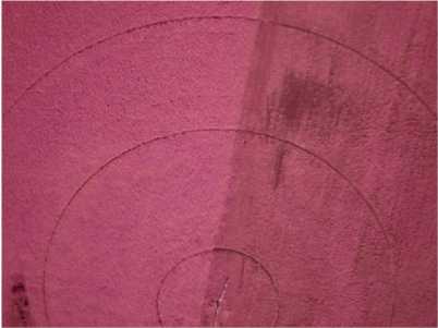
– At surveying on the site with a «Frigate» having moving parts it is necessary to mark the point on the ground. We have developed a sketch of the marker with dimensions (Fig. 3).
Table 2 – Сalculation of ground resolution for three camera
|
Camera |
Date of survey |
Denominator of survey scale |
The resolution of the image - 1 мм |
Ground resolution, m |
|
Canon Power Shot A490 |
4.08.2011 |
272 |
51.84 |
0.0026 |
|
Sony Cyber-shot DSC-W300 |
7.08.2011 |
72 |
29.96 |
0.0012 |
|
Pentax Optio A40 |
21.07.2011 |
191 |
46.54 |
0.0021 |
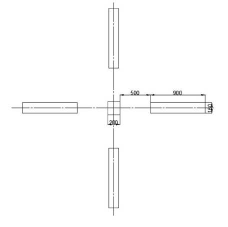
Figure 3 – Sketch of the marker, the dimensions are given in mm
Table 3 – Parameters of air photography
|
Survey parameters |
Indexes |
|
Scale of survey |
1:4000 |
|
Height of survey |
87 m |
|
Survey camera model |
Canon Power Shot A490 |
|
Focal distance of Air camera |
21.6 mm |
|
Images size |
520*390 mm |
|
Ground image base-line: Bx By |
832 m 936 m |
|
Scale of creating plan |
1:1000 |
|
Overlapping: Px Py |
60% 40% |
|
Images number |
3 |
|
Scanning pixel size |
1,7 micron |
– To take a photo of objects provided in the article we offer to select the following snap parameters (Table 3).
-
– We propose to define the images resolution using ground test objects (mire).
In addition we carried out the calculation of economic efficiency of the proposed technology. For this purpose we compared the cost of a survey using mass-produced UAV and UAV assembled at the Moscow State University of Environmental Engineering.
The cost of UAV used for experimental air photography, according to information of the staff of the Moscow State University of Environmental Engineering, amounted to 50,000 rubles, and the average cost of mass-produced aircraft for air photography is 500 thousand rubles to 3 million rubles.
When ordering the air photography from UAV the cost of snapping is about 30,000 rubles per 1 sq.km (for the minimum scope of work.) The cost is affected by the distance of snapping object from basing site of the executor, the scope of work, the complexity of the terrain and the object, as well as the requirements of the customer to the products.
The costs of air photography with use of aircraft vehicle of Moscow University of Environmental Engineering is calculated.
The snapping object is a field with «Frigat» sprinkling machines and part of the urban village «Privolzhsky». The object size is 47 hectares. The object is located 30 km from the city of Saratov. The task is to make images with a spatial resolution of 10 cm, with overlapping 60% in the route and 40% between the routes. Proceed from task the cost of air photography performance is calculated:
-
– Travel time to the work site from Saratov and back (for road transport) - 1.5 hours;
-
– Costs of moving within the study area (search for sites for takeoff/landing, fixing support and tie points, as well as the mire of necessary) - 2 hours;
-
– Preparing for the flight (aircraft assembly, setting the parameters of flight, site preparation for takeoff/landing) - 0.5 hours;
-
– The flight (including takeoff / landing) - 0.5 hours.
Thus, the survey takes 4.5 hours or 0.56 of workday. All process steps in organizing and carrying out the air photography are carried out by two specialists. Below you will find a table 4 showing the calculation of costs of survey.
Table 4 – Calculation of costs of survey
|
N |
Expense item |
Calculation |
Amount, rub |
Notes |
|
1 |
Transportation expenses (POL) |
60km * 0.08 l/Km = 4.8 liters 4.8 liters * 27.30 rub = 131 rub |
131 |
The car VAZ-2104 |
|
2 |
Wage pool |
0.56 days. * 2 pers. = 1.12 pers./day 1.12 pers./day * 1500 rub = 1680 rub |
1680 |
– |
|
3 |
Per diem |
1.12 pers./day*500 rub = 560 rub |
560 |
– |
|
4. |
Accruals for maintenance and repair of the UAV |
1 flight*250 rub = 250 rub |
250 |
Resource of airframe is about 200 flights, then airframe is subject to be replaced. The cost of airframe - 50,000 rubles. |
|
TOTAL |
2621 |
The calculation shows that the costs of air photography of the given site using the aircraft of the University is 2,621 rubles. The calculation of the cost of work in the given site using mass-produced UAV is amounted to 58357 rubles.
We are currently conducting research dedicated to the optimization of the parameters of photography from UAV based on the resolution of the materials and the requirements to work accuracy. We are also planning to improve the technology of planning and mapping software taking into account the obtained results on the basis of accuracy, productivity and cost-efficiency.
We show our appreciation to Professor Zeyliger A.M from Moscow State University of Environmental for providing the survey materials and scientific advice.
References Air photography with use of unmanned aerial vehicle for solution of agriculture and cadastre tasks
- http://www.stroitelstvo-new.ru/geodesy/zemleustroystvo>, 2012
- Zinchenko O.N. Unmanned Aerial Vehicles: application for air photography mapping. «Rakurs». Moscow [electronic resource] -http://www.racurs.ru/?page=681
- Raklov V.P. Cartography and GIS: Textbook for high schools. -Moscow: Academic Project, Kirov: Konstanta, 2011. -page 214
