An enigmatic iron artifact from Oksa bay coast, the North of The Sea of Okhotsk

Author: Vazhenin B.P.
Journal: Arctic and North @arctic-and-north
Section: Historical sciences
Article in issue: 10, 2013.
Free access
A forged iron item found on the Sea of Okhotsk shore displays some similarity with items representing different cultural traditions, but, however, it appears somewhat different from all of them. It can be a walking-stick, pick, graze or poker. Its ethnic origins, place and time of its manufacturing can be established, if providing similar artifacts are reported from other areas.
Iron artifact, graze, chisel, the Evens, the Evenks, the Koryaks, Magadan, tsunami, the Sea of Okhotsk
Short address: https://sciup.org/148320374
IDR: 148320374 | UDC: 551.1/4:931:902/904(571.65)
Text of the scientific article An enigmatic iron artifact from Oksa bay coast, the North of The Sea of Okhotsk
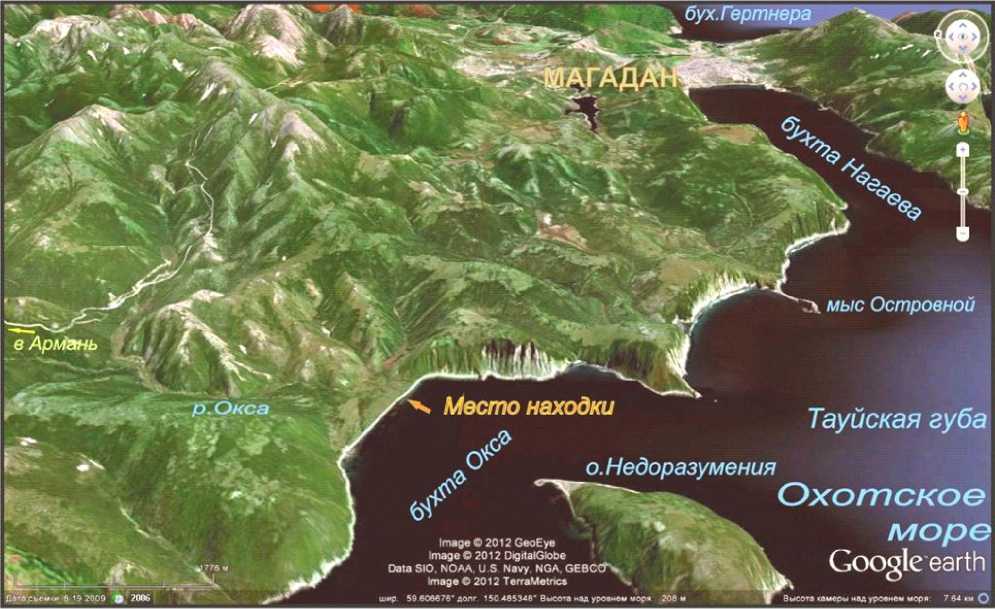
August 8, 2007 during the field work for the study of the geological traces of tsunami in Primagadane on the bay in the north of the Oxus Okhotsk found strange iron artifact that has similarities with several artefacts of different ages and at the same time does not look like the end any of them. These are: a cane, pick, rake, Klevets (or check). The subject of forged steel, has a brown color due to its solid crust overlying oxide, in some places worn on the edges (Figure 1). The appearance of an artifact, despite some design complexity, gives the impression of archaism or home-made, which implies the assumption of its considerable age .
PIC. 1Mysterious object and the place, where it was found
The description of the artifact and its place of its discovery
The artifact, which was found in the top of the bay near the mouth of the Oxus unnamed creek on the south-eastern part of the beach, lined with large boulders on the surface. He was lying horizontally, parallel to the coast, under the newly blurred heavy storm scarp sea accumulative terrace height of about 4 meters, composed of fine gravel, eight alternating layers of buried soils. This terrace formed of tsunami genic peresypi, blocked from the sea part of the ancient Proto-bay Ochs, stretching above the north-east to the foot of the mountains (Pic. 2).
Artifact has its interesting, not so understandable form and if found people could probably be blown away. Bay, despite the fact that it comes through the valley of the Oxus only tractor road 8 km long (from the highway Magadan - Arman), regularly visited by fishermen from Armani (18 km by sea) and Magadan (24 km by sea), because there are found marine fish and crabs, and the Oxus river in summer goes on spawning salmon. Near the bay - on the mainland and on the island of misunderstandings - there are three houses, one or two of which are inhabited permanently. Preserved skeletons of the barracks, and their picture on the old maps showed an increase of the use of local land in the Soviet period. Previously, they were in the sphere of influence and Evens Kamchadals, and from the middle of I millennium BC. e. and to about, XVII century. here, as elsewhere in the North Okhotsk Sea were settled possession sea hunters and fishermen -protokoryakov and Koryak. On the shores of the bay studied their three parking Neolithic and paleometal [1, 1990, p. 27-36].
Pic. 2. The place of discovery of the artifact in the bay Oksa
It is possible and even more likely to hit an artifact of the beach from the terrace deposits as a result of the erosion of its turf-covered ledge heavy storm in the summer of 2007. Insignificance corrosion artifact sufficient to indicate that it is likely to be long in buried, the dry fine gravel of the terrace (Fig. 3), and not at its base, where he was subjected to regular moisture precipitation and periodic action of aggressive - in terms of corrosion - the sea water during storms at high tide, and abrasive machining pebbles and sand with wave-cut of the sea. For these reasons, he would remain here in almost perfect condition for even a few decades. Being in the same terrace gravels, it can be protected from corrosion and water impermeable layers of buried soils. These "pureed" peel oxides only "here and there" on the edges of the artifact may also indicate that the recent hit it on the beach. This section of gravel with layers of buried soils, most likely, could have been formed due to repeated burial of each of the newly formed land cover on the surface of the terrace-peresypi - just the way there, and now, (Fig. 3) - by moving gravel tsunami waves from the adjacent bench and the beach on the surface of the terrace.
Pic. 3. Blurring heavy storm in summer 2007 marine terrace-ledge peresypi up to 4 m, folded small pebbles with layers of buried soils, which was found under mysterious iron object
Contrary to popular belief that it is impossible manifestations tsunami in the north of the Okhotsk Sea due to the low power of earthquakes (with a magnitude of up to 5.8 for the instrumental observation period) on North Ohotskom shelf, they are all the same happened. In 1952, in the next bay Nagayeva entered waves up to 2 m from the South Kamchatka tsunami that de- stroyed the Severo-Kurilsk on about. Paramushir (where the waves reached a height of 10-15 m). The source of this tsunami was the South Kamchatka earthquake of magnitude 8.5 with a fireplace in the Pacific Ocean, east of Paramushir Island and the southern tip of the Kamchatka Peninsula [2, 1998, p. 225-226, 3, 2000, p. 82-84]. Even higher waves - up to 2.2 m - marked tide gauges Nagaevo trading port in 1960 [2, 1998, p. 225-226, 3, 2000, p. 172-174, 4, 1974, p. 29].
In addition to the seismic sources in the northern shores of the Sea of Okhotsk may affect (and weak) volcanic tsunami sources [5, 2006, p. 659-663]. So, as a result of an explosive eruption 1933 severokurilskom Harimkotan island in the Pacific Ocean collapsed volcano Severgina peak of about 80 million cubic meters. m (Fig. 4). This caused a tsunami on the island of Paramushir 150 km to the north-east had a height of 9 m [6, 1964, v. 2, p. 411]. And such a volcano on the Kuril Islands is not unique. There are about 100 land of volcanoes and islands, volcanoes, 38 of them active [6, 1964, v. 2, p. 411]. More than 116 submarine volcanoes found at the bottom of the Sea of Okhotsk near the Kurile island arc [7, 2003, p. 101], each with an explosive eruption could generate a tsunami wave, a significant part of the energy that will be sent to the northern shores of the Sea of Okhotsk. In this case, the explosive nature of the eruption is not something exotic for the Kuril volcanoes. Traces have numerous catastrophic explosions at volcanoes Severgina (island Harimkotan) Alaid (island Atlasova) Daddy (Kunashir Island) [8, 1980, p. 20-44].
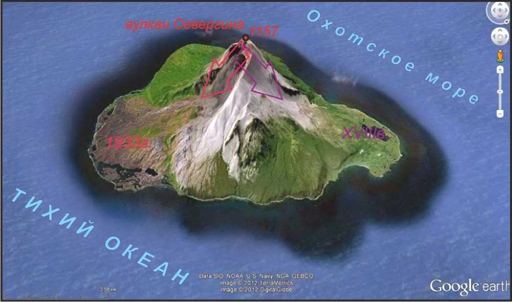
Fig. 4. The island Harimkotan and the volcano Severgina with traces of explosive eruptions in 1933 and in the XVIII century. in two falls from the top, causing the formation of a tsunami in the Pacific (1933) and the Sea of Okhotsk (XVIII c.). The arrows indicate the direction of failure stimulated volcanic landslides: red - in 1933, the violet - in the XVIII century.
A striking example is the volcanogenic tsunami that arose during the eruption of Krakatoa in the Sunda Strait on 26-27 August 1883 waves of the tsunami tide gauges recorded even in the English Channel [4, 1974, p. 29, 9, 1981. 92-93].
The Northern Okhotsk Sea has obvious cumulate properties against tsunami, which improves their impact on the northern shores of the Sea of Okhotsk. So, at the entrance to the tsunami in narrowing the horizontal and vertical bays (such as Tauiskaya lip) and bays (Ochs, Gertner) waves are decelerated, and their height increases, and they come to the shore in the form of a water wall, scrambling, and moves like a bulldozer all in its path. It is no accident that in all these and other tsunami in the Sea of Okhotsk maximum wave height was observed at its northern coast [10, 2010, p. 312-317]. Thus, seismic and volcanic tsunami in northern Sea of Okhotsk were and will be, and lack of information about them is related to the fact that no one was here to geological and geo morphological traces. Therefore, the hypothesis of tsunamigenic burial and then save the iron artifacts buried in the state is not so fantastic as it may seem at first glance.
In general, an artifact like a cross between a style of a letter "G" and "T" and, at the same time, like a stick (Fig. 1 a). It consists of a triangular "core" (Fig. 1) with a length 89 cm, width 1.11.6 cm and perpendicular to it as a "handle" (Fig. 1 b) 12 cm, width 1.6-2 , 4 see "Handle" is located asymmetrically with respect to the axis of "core" (Fig. 1 b). Dimensions of the long and short of it - 8 and 4 cm.
The resemblance ends artifact with a cane. The first difference is that it is forged from steel. The weight of such sticks (610 g) was too large compared to the conventional wood. "Handle" it is inconvenient for a hand - cold, awkward and "neuhvatista", which is exacerbated by the original cross-section of the long end of the "handle". He tetrahedral (Pic.. 1 b), reminiscent of the famous three-linear faceted bayonet Mosin rifle. Long part of the "handle" is narrowed toward the distal end, what looks like a bird's beak straight. Unclear assignment of unusual shape of the crosssection "of the rod sticks" (Pic 1c, d). It almost looks like an isosceles right triangle with a side length of about: 1.2, 1.25 and 1.6 cm top of the right angle is rounded. The other two angles are acute. The long side of the triangle has the form not a straight line but an arc concave inside the triangle (Pic. 1). The curvature of the sides clearly sustained throughout the length of "the rod" in conjunction with its width varying from 1.1 to 1.8 cm Rib "rod" with sharp edges are uneven and wavy. "Core" of slightly tortuous, has two smooth kink in the opposite direction to the deviation from a straight line to 3.9 cm curved it in the plane perpendicular to the long side of the triangular section. His face, coupled with the right angle, differ almost perfect plane. At the distal end of the
"rod" has a ribbed thickening (Pic. 1 d), and when you pair "core" to the "handle" - the edge stiffness (Pic.. 1 b).
The second item, which is similar to the found artifacts is poker, which follows from the almost Г -shaped in its shape. However, there is a short part of the "handle" (in terms applicable to cane), needless to poker, four face long part of the "handle" (Pic. 1 b) and the unusual triangular cross-section, "rod" is making a significant doubt that it is manufactured for tedding coals and ashes in the stove or in a fire.
The discussion of the results
Archaeologist S.B. Slobodin (NEISRI FEB RAS) suggested that at the other end of the "rod" was another "handle." Then the subject would remind long bracket, suitable, for example, to bond logs or log raft. The presence of flat and thin short part of the "handle" and a strange triangular profile "core" does not allow us to consider this version persuasive.
Four planes cross-section of the long "arms" and its pole rotor suggest, the similarities found objects with an almost-forgotten medieval knives called Klevets or check. Klevets (checkan) – is the former shock edged weapon, a kind of battle-ax - had a narrow pole rotor blade and hammer shaped. Klevets of coinage distinguished by a narrow and long beak-blade. Handle length was 0.6 to 2-2.5 m Weight weapon was 1-2.5 kg. It was made of iron, bronze, often, hammers known ancient Chinese jade. In the first millennium BC. e. Klevtsov and hammers were widely distributed in the population of Siberia. They were used to engage the enemy, protected by chain mail and armor. In Russia Klevets used in X-XVII centuries. His penetrating power to the chain mail and armor was higher - in comparison with the sword - by focusing on weapons of mass end of a long handle, and even higher than the battle-ax - by pole rotor blades. Since Klevets and chisel marks of distinction were also military leaders, they were decorated with engraved, inlaid with gold. In the XVII century., Exit from the use of armor, they lose their military significance, but as an honorable weapon and symbol of power persist for some time, including in Russia [11, 1984, p. 335, 805, 12, 2001, p. 727, 13, 2000, p. 66].
"Shaft" (Pic. 1) results in the artifact can be viewed as a handle Klevtsov, long part of the "handle" (for cane, rice. 1 b) - as a pole rotor blades, and the place Hammer shaped (Pic. 1 b). Last discrepancy can be explained in different ways. Butt broke off or break off the ground down and place somehow and cannot be interpreted unambiguously, or he somehow was attached to the short side, or it is not there at all. Lack of butt on such alleged Klevtsov can be explained by the fact that it was not necessary due to a lighter - mostly leather - local enemy armor likely than those used in Europe and China. Adds doubt of the offense as an artifact Klevtsov all the same strange triangular shape cross-section "of the rod-arm" (Fig. 1c, d). It is inconvenient for the hands to strike, as ribbing, but also thin and does not have the necessary rigidity.
Officer of the Magadan Regional Museum I.E. Vorobei said that, it's probably - the Even cane and pick to dig roots and broad concave face (Fig. 1), "rod" is used to bind to it round the stick to increase its rigidity (insufficient without this to be used as impact weapons or even a cane), and to increase "uhvatistosti." You can add to this that the fineness of the rod reduces product weight and saving scarce metal.
Ethnographer L. Hahovskaya (NEISRI FEB RAS) has suggested that the curvature of the "rod" is intentional - to avoid fidgeting bound (not direct) a stick along the "core", but the forging of such an unusual profile, apparently, very demanding and skills. However, due to the low rigidity of "core" it's easy to bend in the right places to match the curvature of a suitable stick.
It is doubtful whether the ancient artifacts are slightly undulated fill in the corners between the edges of the handle tetrahedral or beak resembling electric welding seam (Fig. 1 b). However, even with the VIII-VII millennium BC. e. known method of casting metal welding, in which the parts were heated, and the gap between them is filled with molten metal in the same [14, 1976, v. 23, p. 24-26]. Whether such welding is used in this case?.
Laboratory chief of the Magadan mechanical plant O.I. Metlyakovoy on the "SL-11A" made a spectral analysis of the chemical composition of an artifactSeam with manganese and silicon (0.6 and 0.2%) is close to modern welding electrodes. Yet both the metal itself and the seam is not quite on the same chemical composition with modern counterparts, although this similarity and adds doubt ancient artifact.
Conclusion
Answers to the questions on ethnicity artifact, place and time of manufacture can give search of his counterparts in other regions (including the Evenki in extensive areas), as well as information on the history of ancient metallurgy.
Even if it turns out that the iron object is not as old as it can be assumed, as is, for example, to far creating period of Soviet history, and in this case there are questions about his appointment. Himself this time, just like the others, is worthy of study, including by examining artifacts.
References An enigmatic iron artifact from Oksa bay coast, the North of The Sea of Okhotsk
- Lebedinzev A.I. The ancient maritime culture of the North-Western Okhotsk. Nauka, Leningrad, 1990. 260p.
- Historical information about the tsunami in the Sea of Okhotsk / / Monographic directory. The "Sea." Hydrometeorology and hydrochemistry of the seas. T. IX. Sea of Okhotsk. Issue
- Hydro meteorological conditions. St. Petersburg: Hidro meteo edition, 1998. 370p.
- Aprodov V.A. The earthquake zone. (The nature of the world). Mysl, 2000. 461p.
- Pacific Ocean. Atlas of the Oceans. M. GUNiO USSR Ministry of Defense, 1974. 323p.
- Vazhenin B.P. Kurile volcanoes – are tsunami sources in the northern Sea of Okhotsk / / Volcanism and Geodynamics: Proceedings of the III All-Russian Symposium on Volcanology and paleovolcanology. T. 3. Ulan-Ude: Publishing House of the Buryat Scientific Center of the Russian Academy of Sciences, 2006. Pp. 659-663.
- Short geographical encyclopedia: In 5 volumes. M: Owls. Encyclopedia, 1960-1966.
- International Geological and Geophysical Atlas of the Pacific Ocean. Udintsev GB (eds.). IOC (UNESCO), the Russian Academy of Sciences, Research FFP "Cartography" GUNiO. Moscow, St. Petersburg, 2003. 192 p.
- Melekestsev IV Volcanism and relief formation. Moscow: Nauka, 1980. 212p.
- Bolt B. Earthquake: A public survey. Per. from English. Springer-Verlag, 1981. 256p.
- Vazhenin B.P. The tsunami research problems in the North Sea of Okhotsk / / Problems of Integrated Geophysical Monitoring of the Russian Far East. Proceedings of the Second Regional Scientific Conference. 11-17 October 2009 in Petropavlovsk-Kamchatsky, 2010. Pp. 312-317.
- Military Encyclopedic Dictionary / Prev. Chap. Ed. Commission NV Ogarkov. Moscow: Military Publishing, 1984. 863p.
- The Ancient World: An Encyclopedic Dictionary. Moscow: ZAO Publishing House Tsentrpoligraf, 2001. 975 p.
- Weapons / Comp. A. Gitun. M. Terry - Book Club, 2000. 368 p.
- Welding / Big Soviet Encyclopedia. (30 volumes). Chap. Ed. Prokhorov. Ed. 3rd. M.: "The Soviet Encyclopedia", 1976. T. 23. 640 p.
