Anthropogenic transformation of permafrost conditions of the European North of Russia and their consequences

Author: Iglovsky S.A.
Journal: Arctic and North @arctic-and-north
Section: Biology, the Science about the Earth
Article in issue: 10, 2013.
Free access
The anthropogenic changes of permafrost conditions in the key areas of the European North of Russia − village Koida (Mezenskaya tundra), village Nes (Kanin peninsula), village Shoina (Kanin peninsula), Mezen city, Vashutkini lakes (Bol'shezemel'skaya tundra), Amderma (Yugorsky peninsula), the northern part of the island Vaigach. Geocryological characteristics of sites and the main types of anthropogenic changes in permafrost conditions describe.
Anthropogenic transformation, permafrost conditions, Dvinsko-Mezenskaya plane, Kanin peninsula, Vashutkini lakes (Bol'shezemel'skaya tundra), Amderma (Yugorsky peninsula), island of Vaigach, cryogenic processes
Short address: https://sciup.org/148320375
IDR: 148320375 | UDC: 551.340
Text of the article Anthropogenic transformation of permafrost conditions of the European North of Russia and their consequences
No doubt the need for the estimation of the anthropogenic changes of permafrost conditions of the European North of Russia due to human activities, which is reflected a number of studies [2, 3, 5, 11, 13, 14, 16-21, 25, 26, 28 - 31, 35, 36]. However, it is important to determine the location, nature and specific types of such influences. Need to develop a set of measures that will either be excluded from nature, or to reduce the load on the number of natural complexes located in permafrost.
European North of Russia and adjacent subarctic regions play an important strategic role for socio-economic development. It concentrated large mineral deposits, its abundant biological resources. However, ecosystems differ weak resistance to human impacts and extremely slow rate of recovery. For the study area is characterized by territorial remoteness from the main industrial centers of Russia, patchy distribution of productive forces, the use bio resources potential of landscapes (traditional crafts, nature background), low ecological capacity of the environment. [16]
Permafrost conditions of the research area
In the western part of the Dvina, Mezen plains east Kanin Peninsula permafrost (MMP) are common in the Mezen plain, on the Kanin Peninsula and beyond their southern border width goes to the east. On the coast are widespread thermo karst lake. Mezenskogo Gulf coast of the White Sea and intensively exposed thermo denudation thermo abrasion [1, 3, 7, 14]. Cryogenic processes and thermal abrasion along thermo denudation Abramov (Mesen tundra) and Konushinskogo (Kanin Peninsula) coasts are associated with high tides to 10 m Maximum speed retreat coast in the study area (Morzhovets island, White Sea) occurred in 1869-1882 years. and formed from [1] to 39.5 m / year. On the territory of Dvina-Mezenskaya plains and the Kanin Peninsula meet IMF late Holocene age rare island and type of distribution. MMP temperature range from -0.5 in the south to -1,0 ° C in the north area. IMF power can be up to 15 m in Mezenskaya tundra (Koide vil- lage) and up to 25 m in the east of the Kanin Peninsula [11, 28, 29, 35]. MMP confined mainly to the peat deposit. In the vicinity of the village of Koide MMP found in peat (up to 10 m), but absent in the mineral soil (Fig. 1, 2). The key area of the village Nes MMP found in tundra wetlands (ca- pacity from 0.4 to 1.0 m) and peat (average thickness of 3 m).
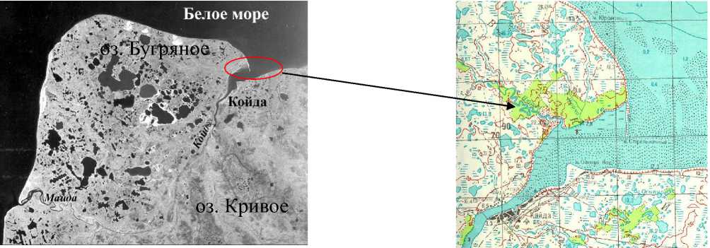
Fig. 1. Fragment satellite image (1986) 1:500 000 scale with the rapid development of thermo karst terrain in northern
Dvina, Mezen plains (bold red line - the zone of birch crooked in the area of karst development)
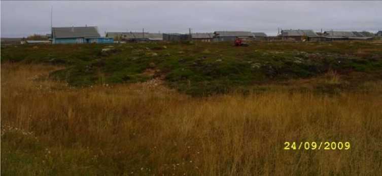
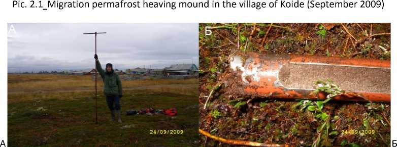
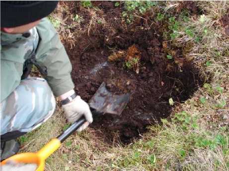
Pic. 2.2. Drilling of the well on the migratory swelling mound: A - Drilling, B - core which revealed non-frozen sand beneath the frozen peat (photo Iglovskogo SA, NG Skyutte)
In tundra Konushinskogo shore height migration heaving mounds up to 2 m in the northern part of the Kanin tundra in the key area of the village Shoina MMP confined to the marshes. Capacity of peat in them ranges from 0.1 to 0.3 m at the height of hillocks from 0.5 to 1 m and a diameter of 3 m Migration heaving mounds have a two-layer structure - this moraine loam (up to 0.7 m), covered top top fyanymi deposits up to 0.3 m by geo ecological zoning [3] territory enters the unstable region with poor defended under-ground water.
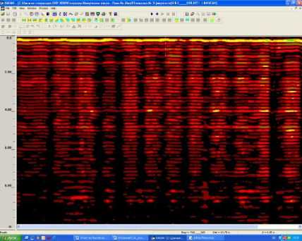
To the south of the hills, large coolie Mylk and the Greater and Lesser Sava Mylk are Vashutkiny lakes, some of which are extended in length by 3-4 km [8, 9]. They fall into the area of continuous permafrost. The maximum capacity of the IMF to 510 470 m recorded on the watershed of the rivers Adzva (Fig. 3) and the Sea-Yu, Shapkina and Black [3]. They are characterized by the lowest in the region of temperature (-5 ° C). Of cryogenic processes should be made frost heave, frost cracking, thermo erosion and thermo karst, solifluction, cryogenic and slumping.
The area is characterized by a wide range of cryogenic phenomena: cracks, polygonal-veined ice, hills and areas of swelling, thermo karst and thermo erosion form. Total area of frost heaving measured in hundreds of meters, the height of hillocks is not more than 2 m, the length of the base widths from 3 to 8 pm Modern thermo karst has spread almost all over the territory. It develops in the most icy lake and marsh and lake-alluvial deposits, which wedges and injectable ice intrasoiled reservoir on ice, as well as less icy glacial-marine and marine sediments. Wide- spread swamps, Aeolian forms on sandy soils.
Б
Fig. 3. Geo radar gramma fragment (river Adzvy, neighborhood Vashutkinyh Lakes): A - yellow line at the top of geo radar gramma - boundary-layer and permafrost, B - depth CTC is 0.2 m visible ice crystals up to 5 cm (photo by S.A. Iglovskogo)
The total capacity of marine Quaternary deposits exceeds 80 m [7]. The southernmost shore of Lake Vashutkinyh terraced height of 15 m, composed of pebbles and boulders. Its area is 8.3 square meters. km [8, 9]. By geo ecological zoning [3] area falls into unstable region with a satisfactory ground water protection.
Coastal area of the Yugra Peninsula enters the zone of continuous permafrost and intensive development cryopeg. For the territory of the characteristic temperatures up to - 5 ° C. IMF power reaches 200 m Amderma thermo abrasion processes developed throughout the coast to the Ugra Bowl and on the shores of large lakes [4, 14, 15]. When wave action is thawing icy sea, lake and marsh, lake and alluvial sediments and massive ice, the further collapse and slumping of rock blocks. The result is a coastal bluffs, often with canopies permafrost in height from 3 to 40 m intensive distributed epigenetic ice wedges mostly in peatlands. By geo ecological zoning [3] area falls into unstable region with a satisfactory ground water protection.
Insularity territory Vaigach creates a characteristic condition of development and continuous permafrost. [15] Dissected topography in the form of rocky ridges up to 150 m is typical for the central part of the island. Between the ridges and marine terraces spread swampy tundra and thermo karst lakes with a total area of about 3% of the territory. Thermo karst lake depth up to 5 m of glacial and tectonic (Lake Yangoto) to 45 m [14, 15]. The average annual temperature ranges from -6,5 ° C in the north of the island and up to -7,0 ° C in the south. For SSC is characterized by rather low temperatures (-5 ° C). Depth of seasonal thawing is 0.2 m in the peat up to 2 m in the sand. Permafrost island is represented by two tiers. The upper tier is composed IMF, whose thick- ness increases from the coast of 10 m to the center of the island - 180 The lower layer consists of chilled rocks with temperatures generally from -1 to -3 ° C, and sometimes below, the power of this stage is reached near the coast of 100 to 300 m has been suggested that in the central part of the island total capacity of MMP than 400 m [4, 14, 15]. Most directly measured during the drilling power MMP was 100 m [4]. The island Vaigach small ice wedges developed in the upper layer of dispersed sediment marine terraces [4, 14, 15]. On Vaigach presents all cryogenic processes. There were various forms of hilly terrain, patches, medallions, process-related swelling. Polygonal-veined structure represented as developing forms (re-growth of ice wedges), and degradation – thermo karst lakes (Talatinskoe), which are formed in the areas with the greatest volumetric ice content of soil [4, 14, 15] (Fig. 4). Solifluction is manifested in the form of terraces on steep slopes. Thermo erosion confined to areas of icy surface soils, sometimes on the beach it is combined with thermal abrasion. By geo ecological zoning [3] area falls into unstable region with a satisfactory ground water protection.
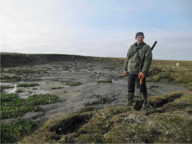
Pic. 4. Solifluction circus, which was formed as a result of solifluction splyva material on unstable slopes (Vaigach Island, August 2010) (Photo J.H. Bolotov)
Material and Methods
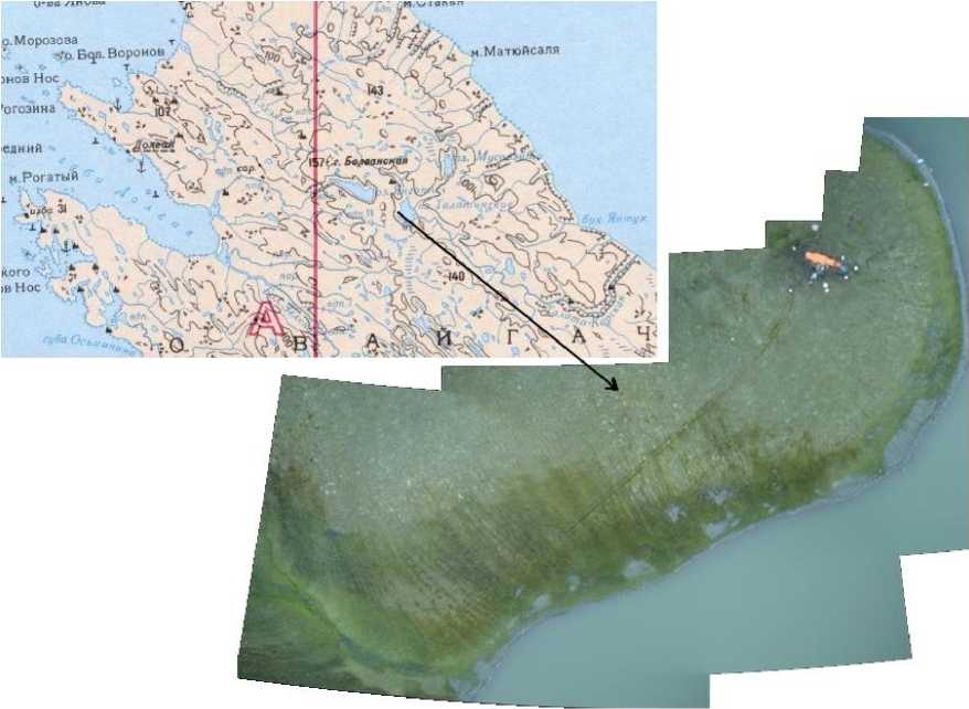
The study of anthropogenic transformation of the IMF European North of Russia carried out a number of key areas Dvina, Mezen plains and the Kanin Peninsula - in the village of Koide (Mesen tundra) in June-September 2000, 2001, 2005, 2009., In the village of Nes on the Kanin Peninsula in June and August 2002, in the village Shoina Kanin Peninsula in July-August 2003, in the town of Mezen in 2003, around the lake, you Vanyukov (Vashutkiny lake Bolshezemelskaya tun- dra) in July 2009, 2010. in Amderma (Yugra peninsula) and in the northern part of the island
Vaigach in August 2010 [3, 5-7, 13, 17, 18, 21, 23, 24, 32, 35] (Pic. 5).
The area of the research was 5 key sites square. km. Traversed pits in permafrost heaving mounds of migration to 1.5 m depth were measured seasonally thawed layer (SPC), ground tem- perature below the CCC, GPR survey conducted to a depth of 35 m with a GPR SIR-3000, with a set of antennas Subecho-40 (40 MHz), Subecho-70 (70 MHz) (Geoscanners, Sweden), 501 (400 MHz) (GSSI, USA) on a conveyance devices with work in bistatic mode and bind the coordinate data describing the cryogenic processes, types of human activities on frozen landscapes and the extent of human impacts on them.
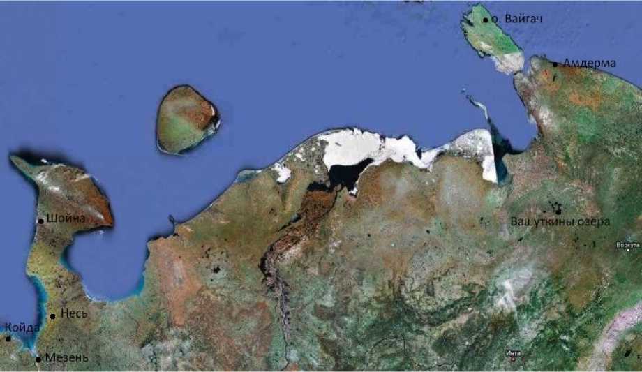
Pic. 5. Overview map of the study area of anthropogenic changes in permafrost conditions Dvina, Mezen plain Kanin Peninsula, Vashutkiny Lake (Bolshezemelskaya tundra), Amderma (Yugra Peninsula), the northern part of the island Vaigach. Legend: • - key areas which conducted field studies
Results and discussions
Using the classification of human impact on the environment by A.G. Isachenko [13], the author divided the impact of the study region into two types:
-
1) impacts associated with gathering, hunting, grazing, directed mainly to the use bio resources potential of landscapes (traditional coastal fisheries, environmental background);
-
2) the impacts associated with the production and urbanization. Main sources of the second type (enterprise, public utilities, roads) have little (focal or linear) distribution pattern and confined mainly to the settlements on the White (village Koide, Nes, Shoina), Barents and Kara (Amderma, Vaigach Island) seas.
Maximum spatial distribution has a background of nature. It includes the following types: traditional use of indigenous people, forestry and resource-trade. [13]
Anthropogenic disturbances, changing the properties of the components and their interactions in the natural environment, can serve as a "trigger" for the development of adverse destructive cryogenic processes. [11] At high ice content of deposits in all key areas of tampering cryogenic landforms with anthropogenic disturbance provokes a catastrophic change in permafrost terrain. Given the fact that the coastal zone aggradation thermo denudation actively influence processes and thermal abrasion, in combination with anthropogenic disturbances are destroyed heaving mounds of migration, the development of thermo karst lakes and their subsequent discharge into the sea, which causes permanent loss of coastal land areas.
Damage to the integrity of the immigration heaving mounds composed of sediments with very high, can dramatically increase the thawing permafrost, which in turn will develop adverse destructive cryogenic processes (thermo erosion and thermo karst) and swamp formation [1, 3, 5, 7, 14].
Considering the situation on permafrost and anthrax cattle burial in the European North of Russia for the past 40 years, we can draw the following conclusions. Most of the continuous permafrost zone (through the Naryan-Mar - Vashutkiny lake by 68 °. Lat.) For the period from 1970 transformed into a zone of partial distribution to, what led to the thawed zones [21, 22]. So, in the basin Tedinyaha, Peheheyaha, Urenyaha (disadvantaged anthrax), the depth of thawing in the period from 1970 ranged from 6 to 8 m in Vashutkinyh lakes - from 4 to 6 m, the western part of the basin Adzva - 8 9 m, the river Korataiha - from 5 to 7 m, rivers Yunyaha, Yareyyu - from 6 to 10 meters, the river Yunkoshor - from 6 to 12 m in the Kara lips - from 5 to 7 meters, the river Tab-U -from 4 to 6 meters in the north of the NAO (area south of Bolvansky lips Ureryaha basin, river basin Yunkoshor, neighborhood Amderma) also reported sporadic occurrence thawed zones in areas disadvantaged by anthrax.
We can conclude that occurred significant "restructuring" permafrost of northern European Russia in the last 40 years (Fig. 6). She put it: the receding north to tens of kilometers of the southern border of permafrost areas and zones of continuous permafrost and a significant increase in power not through taliks the pre-specified period, reducing the area of permafrost due to the appearance of new taliks; dramatic increases MMP and development of thermo karst subsidence [21 , 22].
Transformation of permafrost conditions of anthropogenic change can be seen in several aspects. [17] However, the form of violation of the natural landscape components MMP in them- selves reduce the quality of land and the narrow scope of the possible nature of the tundra. As- sessment of the sustainability of geo-ecological conditions of the European North of Russia can be done on the following parameters: sensitivity of permafrost engineering and to the destruction of the land cover and pollution, protection of groundwater from surface contamination.
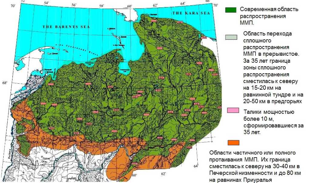
Области частичного или полного протаивания ММП. Их граница сместилась к северу на 30-40 км в Печерской низменности и до 80 км на равнинах Приуралья
.THE KAkA SEA
Область перехода сплошного распространения ММП в прерывистое. За 35 лет граница зоны сплошного распространения сместилась к северу на 15-20 км на равнинной тундре и на 20-50 км в предгорьях
Талики мощностью более 10 м, сформировавшиеся за 35 лет.
Современная область распространения ММП.
Pic. 6. Changes in permafrost since the 1970's. by 2009 in the European North of Russia [21, 22]
Virtually all of the research area of permafrost can be attributed to the area "very sensitive" to the appearance of exogenous geological processes in the destruction of soil and vegetative cover. Parts of it are differentiated by the degree of protection of groundwater. [3]
Consequences of the anthropogenic transformation of permafrost conditions
Multiple aspects of business, engineering and construction activities and equipment require large number of specific types of human-induced change of permafrost conditions [12, 13]. For the territory of Dvina-Mezenskaya plain Kanin Peninsula, Vashutkinyh lakes Amderma, northern part of the island and found Vaigach author identifies the following specific types of human transformation.
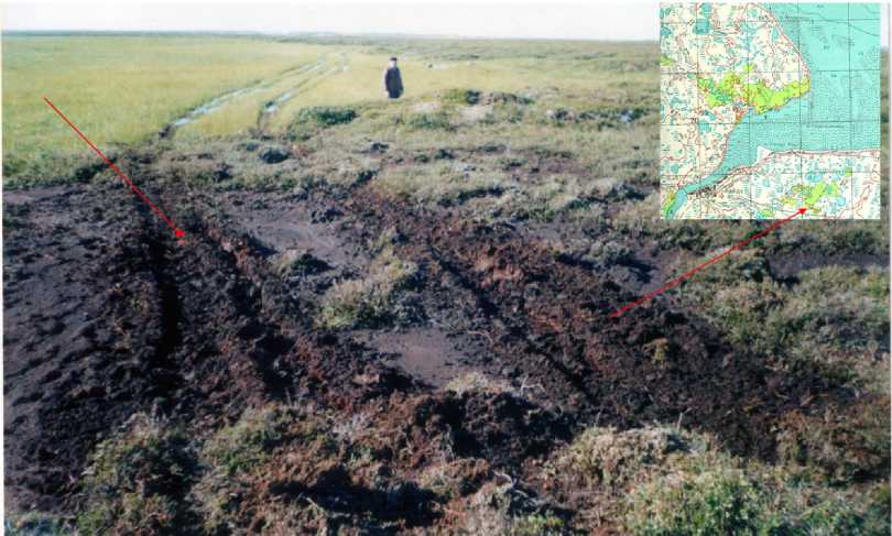
Local disturbance of vegetation on single passage tracked vehicles leads to rutting and mixing of soil horizons, which is celebrated in all the studied areas. In disturbed areas of soil has a higher temperature, a greater depth STS. Repeated passage (12 times in the tundra, up to 6 times in the swamp) tracked vehicles leads to the destruction of land cover, changes in the upper soil horizons and micro relief with rutting, erosion and thermo karst development process, which is observed along the temporary roads around villages along Abramovskaya (Mesen tundra) and
Konushinskogo (Western Kanin Peninsula) Mezenskogo Gulf coast of the White Sea, in the vicinity of lakes and Vashutkinyh Amderma, partly Vaigach Island (Lake Yangoto, Talatinskoe). On the road, to stop southern tundra wetlands, vegetation recovers very slowly (Fig. 7). It is known that the succession recovery of such sites can take 20-25 years [3, 35].
А
Б
Pic 7. Land development thermo erosion: A - near the village of Koide (2000), B - near Lake Talatinskogo, Vaigach Island, (2010) after a single passage through the ridge of tracked vehicles migration heaving bounds (photo by
S.A. Iglovskogo) Valikova zone (unmanned aerial Gofarov M.I.)
Piles of soil are removed to the transformation of the micro relief, burial and destruction of vegetation, soil, redistribution of snow, hydrological regime around the settlements, as noted in the villages of Koidu, Nes, Shoina, Amderma. Digging pits leads to violations of the integrity of the local surface of the IMF (village Koide, Shoina, settlement Amderma). Thus, in the village of Koidu residents was made an attempt to dig up the ridge migration mounds heaving a 200 and a length of 600 m for the subsequent use of these lands for agricultural purposes. However, the result on the site was generated firebox peat bogs, and the site in the center of the village has been withdrawn from use. Construction site without following the rules and the second principle of building on frozen soils is accompanied by the destruction of the IMF, the development of thermo karst, thermo erosion, breach of vegetation, destruction and deformation of objects in the integrity of the array of the IMF (Koide village, Nes, Shoina). They all ended deformation structures as soil compaction has taken place and the presence of frost heave is not taken into account.
Local pollution STS and upper layers of permafrost fuels and lubricants leads to the accumulation and concentration in these layers of oil from the operation of facilities. Failure to comply with the rules of operation when working with fuel and lubricants in most filling stations, located mainly in the areas of military units, communications port and airport on the White and Kara Seas (city Mezen Koide village, Kamenka, Shoina, settlement Amderma ) identified oil spills in the STS. This has implications for contamination of surface and ground water and the destruction of the land cover. Required reclamation. In areas of melted rocks such spills lead to a deeper accumulation of oil in the spill area. Installed water pollution by oil products, exceeding MPC in tens and hundreds of times, in a fuel depot in the village of Kamenka and Mezen Mezenskogo district. [11] This causes the creation of all the local fields and streams of contamination in cryogenic landscapes are powerful potential mechanisms of physical-chemical, mechanical, biotic and other changes in these areas.
In the tundra and forest-tundra zones almost universally observed effects of deer grazing on the vegetation cover, which is expressed in delihenizatsii of tundra. The most easily broken marsh and moss tundra. At long parking deer herd grass-sedge-moss tundra destroyed completely. Significant effect on the upper layers of frozen soil have thousands migration of domestic and wild reindeer from the North Kanin Peninsula in the Southeast White Sea-Kuloy plateau (village Shoina, Nes, Koide) in Vashutkinyh lakes. Under current count of the total number of deer grazed on the NAO in 176 thousand heads [16], including up to 30 thousand in the Kanin Peninsula, an evaluation of the impact of their grazing on permafrost landscapes. Repeated use of the technique leads to noise pollution, which has a disturbing effect on animals tundra (village Nes, Shoina, Vashutkiny lake).
At the moment, the intensification of natural resources in the research area due to the orientation of the majority population to use bio resources capacity of traditional crafts. All this can amplify human influence on the freezing conditions of the area.
Analyzing the situation to spread on the territory in the anthrax cattle burial, most of which are now in a mess, you can make the following assumptions. The greatest changes in temperature of the IMF (an increase of 1 ° C) occur in the eastern part of the NAO and river Komi (Urals, Pai-Khoi). Here, you may want to pay attention as troubled anthrax districts: Small basins Usa, Big Syryaga, Halmershor (Komi Republic), Yunkoshor, Kara Bay neighborhood, the river Tabyu (NAO). In this area will continue geo cryological change the situation. May increase the water content and wetlands, increased cryogenic processes (thermo karst, frost heave, thermal abrasion shores of seas and lakes) [21, 22]. Temperature increase of 0.4 to MMP 0,6 ° C can affect disadvantaged anthrax territory east of the river Porchtyvys, Syadeyyu, Adzvy, Pyayyu, Vashutkiny lake, Savaii, Syarnayu, Yareyyu, Yunkoshor. Temperature increase of 0.2 to MMP 0,4 ° C can capture almost all the NAO. The depth of thawing in 2020 could reach near Vashutkinyh Lakes, Western Basin Adzva of 1 to 2 meters, the river Korataiha - up to 1 m, rivers Yunyaha, Yareyyu - up to 2 meters, the river Yunkoshor - 4 m in Kara lips - to 1 m, the river Tab-U - 1 m to the south of Bolvansky lips Ureryaha basin, river basin Yunkoshor, neighborhood Amderma possible sporadic appearance of thawed zones in areas disadvantaged by anthrax.
Currently in the Kanin Peninsula, Ugra, Bolshezemelskaya Malozemelskaya tundra and changes the environment in more than two dozen centers, most of which have developed in the field of hydrocarbons. If 30 years ago, these areas were mainly territory ecological framework, now there is a constant increase in the impacted areas and impacts on permafrost conditions in the area that could occur and others [10].
The greatest mechanical effect on permafrost conditions, leading to the appearance of man-made landforms, providing the mining complex, located in the Vorkuta region. Special significance of the above problems in connection with the natural features of the area under consideration, due to confinement to the northern latitudes and slow recovery process. [10]
Measures to reduce the anthropogenic impact
Necessary to create an effective strategy for developing the territorial system "nature -population - economy" where regulatory mechanisms should certainly speak environmental, legal and economic mechanisms.
One of the solutions to this situation can be justified and the creation of a network of protected areas (PAs). On the Kanin Peninsula there is one P.A.Shoinsky Biological Reserve (area 164 sq. km.) On the unique wetlands of the White Sea with sea Layden and the mouth of the river and Shoina Thorne. Necessary to create on the Kanin Peninsula natural monuments of regional significance. [11] Among the rare plant species should be included in the list of monuments of nature: the area Mikulkina Nose (northeast Kanin Peninsula) from the mouth of the Pearl River to the north with a 25-km (common endemic species of plants), the most northern "forest island" in the western part of the peninsula near Cape Kanin Konushin Shomohovskih on hills. On the steep bank of the Cape in the frozen peat is well preserved birch stumps and trunks of spruce, is a relic remains of "thermal optimum 'Holocene. You must save the larch "island" in the river valleys and Nes Semzha (south Kanin Peninsula). Siberian larch is located at the northern limit of distribution. Necessary to create a natural monument "Colony Barnacle Goose" between the rivers and Shoina Kambalitsy (Kanin Peninsula).
Institute of Biology, Komi Science Center developed a project to establish a biosphere reserve in Vashutkinyh lakes. Unfortunately, the project has not been implemented in practice. Necessary to create a reserve, which could contribute to the conservation of this unique place. On the territory of Vashutkinyh lakes is important bird area of international importance. Necessary to include land in the list of wetlands of the Ramsar Convention to the status of national importance [11, 31].
A good example of environmental policy can serve Vaigach Island, which, thanks to its geographical location is of strategic importance and with increasing volumes of cargo transportation along the Northern Sea Route and increase hydrocarbon production will experience a growing anthropogenic pressure. Reserve status will help to conserve the flora and fauna of this unique area, historical and cultural heritage of the North and the Arctic landscape. Of the Red Book of the NAO on the island grows 10 species of lichens, three moss species, 47 species of vascular plants, 26 species of birds inhabit, six of which are included in the Red Book of the Russian Federation and the NAO. The territory is one of the most popular nesting waterfowl on the west of the Russian Arctic. The total area of the reserve is 242,778 hectares. Still in need of protection and Atlantic walrus rookery located on Cape Large Lyamchin nose Islands Karpovo becomes and more deer. The reserve are more than 230 cultural heritage sites. For the Nenets people Vaigach Island has historically sacred status. The island preserved traditional crafts associated with the use bio resources capacity: herding, hunting, and fishing. Currently, human impact small and confined to the neighborhood Varnek village in the southern part of the island. Local roads tracked reported in the north-western part of the island and are associated with geological activity.
Thus, there are 10 protected areas (PAs) covering 974.05 hectares in NAO, of which 797 hectares - is part of the land with ponds and 181.9 hectares - the sea area. Land portion of the protected area is only 4.5% of the area of the district, which is small in the face of strong economic development in the territory. [31]
Reaching and projected changes in permafrost conditions can significantly influence the situation in areas where anthrax cattle burial, especially in those areas where common with very high MMP that result thawing can lead to increased water logging areas and thermo erosion thermo karst activity. Necessary to conduct geotechnical and permafrost research in the field in order to clarify the situation and to develop measures to protect against emergencies in close collaboration with the users of the territory, the administration of villages, districts, counties, emergency, etc.
Conclusions
Ecosystems of the Northern European Russia differ weak resistance to human impacts and extremely slow rate recovery. This largely determines the specifics of the biota and ecosystems. Among the types of human activities should highlight those that are associated with gathering, hunting, grazing and are aimed primarily for use bio resources potential of landscapes, as well as those effects which are associated with local zones of production and urbanization. Settlement enterprise, housing facilities, roads, airfields, military bases have IMPACT - focal or linear - the nature and distribution in the study area are confined mainly to the coast of the White, Barents and Kara Seas. We should note the kind of local human impacts inherent in the entire region. This is a violation of vegetation when driving tracked vehicles, and the construction site without following the rules and principles of construction on frozen ground, accompanied by the destruction of the IMF, the IMF and local pollution with fuel, lubricants, heavy metals, leading to the accumulation and concentration of these pollutants in the STS and a number of others.
Small indigenous people of the tundra preserves traditional crafts associated with the use bio resources capacity: herding, hunting, and fishing. Significant effect on the upper layers of frozen soil have driven thousands of reindeer migration that lead to tundra. Migration routes heavily disturbed wetlands and moss tundra. At long parking deer herd grass-sedge-moss tundra destroyed completely. The formation of secondary succession. The need for monitoring of traditional migration routes of deer in order to determine the extent of human influence on permafrost land- scapes and measures to reduce it, as well as the effects of climate change on the time and space to shift their migrations.
Now in the Kanin Peninsula, Ugra, and Bolshe zemelskaya Malo zemelskaya tundra is a change of the environment in areas where hydrocarbon deposits are developed. If 30 years ago, they were chiefly territory ecological framework, now there is a constant increase in the impacted areas permafrost zone of impact.
References Anthropogenic transformation of permafrost conditions of the European North of Russia and their consequences
- Are F.E. termoabrasion coasts. Pergamon Press, 1980, 158 p.
- Vasilchuk Y.K., Vasilchuk A.K. Sulerzhitskii L.D. Budantseva N.A., Volkov E.M., V. Chizhov Radiocarbon chronology heaving mounds Bolshezemelskaya tundra-ry / / DAN, 2003. T. 393. Number 1. Pp. 101-105.
- Permafrost and the development of oil and gas regions. Edited by E. Melnikova (parts I, III) and S.E. Grechishcheva (Parts II, III, IV). Moscow: GEOS, 2002. 402p.
- Wittenburg P.V. The thermal regime and mine waters in the permafrost zone of the island and Vaigach Amderma / / Problems of the Arctic. Number 9. 1939. Pp. 5-29.
- Garagulya L.S. The method prognostic assessment of anthropogenic changes in permafrost conditions (for example, flat areas). Moscow: Moscow State University Press, 1985. 224 p.
- Permafrost (frozen ground) research. Guidance. Moscow: USSR Academy of Sciences. 1961. 423p.
- Geocryology of the USSR. European territory of the USSR. Nedra, 1988. 385p.
- Goldin L.P. Geography Bolshezemelskaya tundra lakes. Nauka, Leningrad, 1972. 102 p.
- Zvereva O.S., Vlasova T.A., Goldin L.P. Vashutkiny lake and the history of their study of the / / Hydrobiological study of lakes and fisheries development of the Far North of the USSR. Nauka. 1966. Pp. 4-21.
- Duskova D.O., Evseev A.V. Analysis of the anthropogenic impact on geo systems of the Northern European Russia and the Arctic North. 2011. № 4 (November). [Electronic resource]. URL: http://narfu.ru/upload/iblock/673/16.pdf (date of access: 12/24/2012).
- Iglovsky S.A., Schwartzman G. Bolotov I.Perma frost of Dvina, Mezen plains and the Kanin Peninsula. 2010. Arkhangelsk. IEPS UB RAS. 124p.
- Newsletter press center Plesetsk cosmodrome. 1991. Number 2. 1.
- Isachenko A.G. Ecological Geography of Russia. SPB.: Publishing House of St. Petersburg. University. 2001. 328 p.
- Kozlov S.A. Hazardous oil and gas geological structures and natural-technological processes on the Western Arctic shelf of Russia / / oil and howling thing. 2005. [Electronic resource]. URL: http://www.ogbus.ru/ authors / Kozlov/Kozlov_2.pdf (date of access: 24/12/2012).
- Koreysha M.M. Permafrost Vaigach Island / / Journal of Geocryology, V. 2, 2000. [Electronic resource]. URL: http://www.netpilot.ca/geocryology/number2/ koreisha2.html (date of access: 12/24/2012).
- Krasovskaya T.M. Nature of the Russian North. Moscow: Publishing House of LCI. 2008. 288p.
- Marahtanov V.P. The matrix model of the dynamics of human lithogenic basis permafrost landscapes / / Problems of General and Applied Geo-ecology of the North. Moscow: Moscow State University Press, 2001. With 68-85p.
- Melnikov V.P., Spesivtsev V.I. Cryogenic education in the Earth's lithosphere. Novosibirsk. SIC UIGGM SB RAS, Acad RAS, 2000, 343 p.
- V.A. Koshelev, Borovik O., Kondratenko A.V. Kolchin N.L. Geotechnical and permafrost features coastal shelf of the Barents / / Proceedings of the RGS. 2007. No. 1. Pp. 37-51.
- Oberman N.G. Geo-ecological specificity and the current trends of natural and anthropogenic dynamics of permafrost of the East European Subarctic / / Proc. 1st Conference geocryologists Russia. T. 2. Moscow: Moscow State University Press, 1996. p. 408-417.
- .Oberman N.G. Frozen rock and cryogenic processes in the Eastern European Subarctic / / Soil Science. 1998. Number 5. p. 540-550.
- Oberman, N.G. Lygin A.M. Prediction of permafrost degradation on the example of the European North-East of the country / / Exploration and conservation of mineral resources. 2009. Number 7. Pp. 15-20
- Pavlov A.V., Anan G. Evaluation of contemporary changes in air temperature in the permafrost of Russia / / Cryosphere, 2004. so VIII. Number 2. p. 3-9.
- Pavlov A.V., Anan G.V., D.S. Drozdov, etc. Monitoring seasonally thawed layer and the temperature of the frozen soil in the north of Russia / / Cryosphere. 2002. that VI. Number 4. p. 30-39.
- Pearlstein G.Z., Pavlov A.V., A.A. Buiskikh Permafrost changes in today's climate / / Geoecology, engineering geology, hydrogeology, geo-criology. 2006. Number 4. Pp. 305- 312.
- Solomatin V.I. Geocrionology. Theory and methods of cryogenic geo-systems in the technological impacts / / Problems of General and Applied Geo-ecology of the North. Moscow: Moscow State University. 2001. Pp. 5-14.
- Stankiewicz E.F. Quaternary Vashutkinyh area lakes and rivers Labogey-Yu and Nyartey Yaga / / Proceedings of the All-Union Conference on the Study of the Quaternary period. Volume II. Moscow. 1961. p. 12-16.
- Shwartzman G. Bolotov J.H., Iglovsky S.A. Modern geoecological the state of tundra landscapes Mezenskaya / / Bulletin Pomeranian University Press, 2003 a. A series of "natural and physical sciences." № 1 (3). Pp. 42-55.
- Shvartsman, G., I. Bolotov Iglovsky S.A., Polikin D.Y. Modern geo-ecological condition Kanin tundra landscapes / / Bulletin Pomeranian University. A series of "natural and physical sciences." Arkhangelsk: Pomor State University. Lomonosov. 2003 b. Number 2 (3). Pp. 13- 28..
