Application of remote sensing to extract flood areas using ENVISAT ASAR data
Автор: Trinh Le Hung, Andrade E.R.M., Pham Tuan Anh
Журнал: Вестник аграрной науки @vestnikogau
Статья в выпуске: 1 (52), 2015 года.
Бесплатный доступ
Flooding is the most common natural disaster and can occur anywhere. Heavy rain is the most frequent cause of floods, but there are many other natural triggers, including hurricanes, tidal surges, ice jams and snow melt. Radar images with many advantages over optical images such as no cloud coverage or solar illumination problem have been effectively used for flood monitoring. In this study, for extraction of flooded areas, pre and post event ENVISAT ASAR satellite images were analyzed. The results obtained in this study can be used to immediate assessment of flood risk and damage.
Flood, remote sensing, envisat, sar, classification, damage
Короткий адрес: https://sciup.org/147124219
IDR: 147124219 | УДК: 528.854.2
Текст научной статьи Application of remote sensing to extract flood areas using ENVISAT ASAR data
Floods are the most frequent and costly natural disasters in Bangladesh resulted from typical tropical monsoon climatic features, in addition to the intensifying topographic characters and recent climate change. Therefore, flood map are indispensable tools to provide information for monitoring flood hazard and risk.
Remote sensing data has been widely used for flood mapping and monitoring [1-6]. If optical data's utility in flood detection depends on cloud cover, microwave remote sensing technique with all weather monitoring capability and its large coverage is an important tool in flood monitoring [5]. So, SAR image appear highly to plain flood monitoring over large areas due to the appropriateness of its wide coverage and all weather capacity [1-5].
One of the major advantages of using SAR images corresponds to the ease of distinguishing between water and other classes, given by the high contrast that exits. Water bodies act as a mirror reflecting surface, their response is low backscatter coefficient in SAR images and then looks like a dark area [6]. This article discusses the contribution of multitemporal ENVISAT ASAR Wide Swath Mode data in detection of water bodies for flood affected areas of the delta of the Meghna river, in Bangladesh.
MATERIAL AND METHODOLOGY
Study area. Meghna river is one of the most important rivers in Bangladesh (Ganges, Brahmaputra, Meghna), one of the three that forms the Ganges delta, the largest on earth fanning out to the Bay of Bengal [8].
Flooding is a natural annual phenomenon in Bangladesh. The rivers are large by international standard, and can inundate over 30% of the land mass. The coastal flooding twinned with the bursting of Bangladesh's river is common and severely affects the landscape and Bangladeshi society. 75% of Bangladesh is less than 10m above sea level and 80% is flood plain, therefore rendering Bangladesh a nation which has a lot of risk of further widespread damage [8]. Each year in Bangladesh about 26000 km2, (around 18%) of the country is flooded, killing over 5000 people and destroying 7 million homes. During severe floods the affected area may exceed 75% of the country, as was seen in 1998. This volume is 95% of the total annual inflow. By comparison, only about 187000 million m3, of stream flow is generated by rainfall inside the country during the same period. The floods have caused devastation in Bangladesh throughout history, especially during the years 1966, 1987, 1988 and 1998. The 2007 South Asian floods also affected a large portion of Bangladesh [8].

a)
b)
Figure 1 - The difference in Ganges – Brahmaputra – Meghna rivers flooding in Bangladesh from MODIS images (a – 03 – 08 – 2007, b – 01 – 05 – 2007) [9]
The severity of the floods can be seen in the contrast between two MODIS images, which was taken on May 1, 2007 (1a) and August 3, 2007 (1b).
Materials. ENVISAT (Environmental Satellite) is an inoperative Earth-observing satellite, which launched on 1 March 2002 aboard from the Guyana space centre in Kourou. ASAR (Advanced Synthetic Aperture Radar) operates in the C band in a wide variety of modes. It served as a data link for ERS 1 and ERS 2, providing numerous functions such as observations of different polarities of light or combining different polarities, angles of incidence and spatial resolutions [10]. The characteristics of ENVISAT ASAT data showed in table 1.
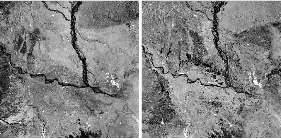
For extracting and mapping flooded areas, in this study we used multi-temporal ENVISAT ASAR image: one acquired on 26 July 2007 (post – flooding, fig. 2a) and another on 12 April 2007 (pre – flooding, fig. 2b) with spatial resolution 150 m.
Table 1 - The characteristics of Envisat Asar data [10]
|
Mode |
Id |
Polarisation |
Incidence |
Resolution |
Swath |
|
Alternating polarization |
AP |
HH/VV, HH/HV, VV/VH |
15 - 45° |
30 - 150 m |
58 - 110 km |
|
Image |
IM |
HH, VV |
15 - 45° |
30 - 150 m |
58 -110 km |
|
Wave |
WV |
HH, VV |
400 m |
5 x 5 km |
|
|
Suivi global (ScanSAR) |
GM |
HH, VV |
1 km |
405 km |
|
|
Wide Swath (ScanSAR) |
WS |
HH, VV |
150 m |
405 km |
a)
b)
Figure 2 - ENVISAT ASAR image pre- (a, 12 - 04 - 2007) and post-flooding (b, 27 - 07 - 2007)
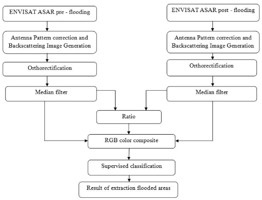
Figure 3 - Method of extraction and mapping flooded areas
Methodology. In pre-processing steps, the pixel intensity values of multi-temporal ENVISAT ASAR images (pre and post-flooding) are converted to a physical quantity called the backscattering coefficient or normalized radar cross – section measured in decibel (dB) units. In the next step, the speckle noise is suppressed by applying a median filter on the digital image, then ratio of pre and post – flooding images are calculated. In the last step used supervised classification to detect and extract flood areas from ENVISAT ASAR data. The algorithm for detecting and extracting flood areas from ENVISAT ASAR image showed in figure 3.
RESULTS AND DISCUSSION
Pre-processing ENVISAT ASAR data. Pre-processing consists of the calibration and orthorectification of ENVISAT ASAR image. The antenna pattern was corrected and data ware converted in to linear backscattering values to the following equation:
o
DN 2 / Rd \4
К . к R ref /
(^.sin^ )
(1),
where: K is the absolute calibration constant, DN2 is the pixel intensity, G2 is two – way antenna gain at distributed target look angle, Rd is distributed target slant range distance, Rref is reference slant range distance and Ij is incidence angle at each pixel location.
Finally, the backscattering coefficient is expressed in decibel units to the following equation:
o J j0 (decibel) = 10. log10(o70) (2)
Filtering. The homogeneous areas on ENVISAT data were enhanced using iterative processing with a growing window size relying on the alternate calculation of two sub-filters based on a moving median filter 7 x 7 window size.
Changing detection calculation. A ratio method was preferred to extracting flooded areas. Band rationing is a useful method of preprocessing satellite image, especially in areas where topographic effects are important. The reason for this is twofold: one is that differences between the spectral reflectance curves of surface types can be brought out. The second is that illumination and consequently radiance may vary the ratio between an illuminated and an unilluminated area of the same surface type will be the same. The ratio image is applied to homogenized data resulting from following equation:
D _ ^re -flooding
(3),
R = 7-------- ipost -flooding where: Ipre-flooding is calibrated backscattering value on the texturally filtered image at a time pre - flooding and Ipost-flooding is calibrated backscattering value on the texturally filtered image at a time post – flooding?
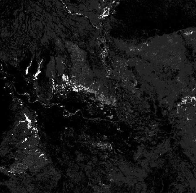
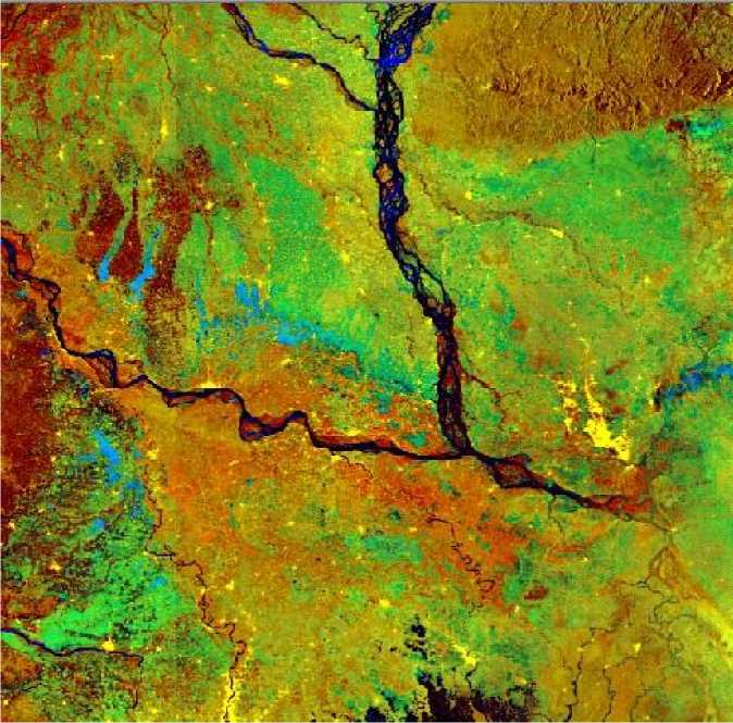
RGB color composite. A color composite is elaborated to enhance flood changes with the aim of facilitating their representation and interpretation with the post – flooding image, the pre – flooding image and the change detection ratio image R in RGB. This color composite highlights permanent water between the two dates in dark blue, infilling or submersion of land surfaces in light blue, and the positive changes such as land surface in red (fig. 4b).
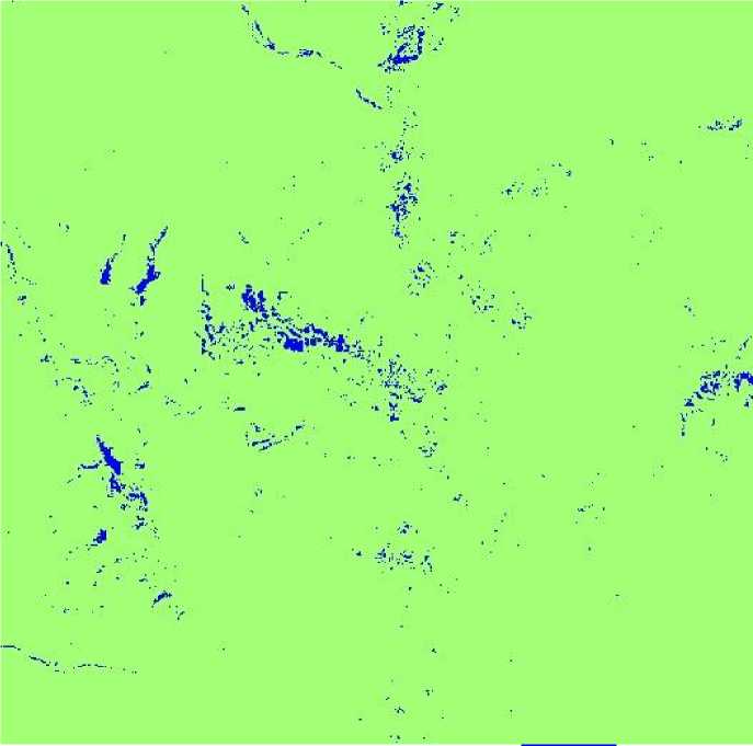
Supervised classification. Change extraction flooded areas performed by supervised classification to the color composite elaborated above. The most powerful classifier in common use is that of Maximum Likelihood. Based on statistics (mean; variance/covariance), a (Bayesian) probability function is calculated from the inputs for classes established from training sites. Each pixel is then judged as to the class to which it most probably belongs. The result of classification flooded areas showed in fig. 5.
a)
b)
Figure 4 - Band ratio image (a) and result RGB combination (b)
Flooded areas
Figure 5 - Result of classification of flooded areas
CONCLUSIONS
Satellite remote sensing images are useful data sources to detect, determine and estimate the flood extent, damage and its impact. The analyses of this study showed that extraction flooded areas was focused on plain flood recognition using ENVISAT ASAR Wide Swath Mode data which appears highly adapted to large sensitive area monitoring. SAR data has the advantage of penetrate through cloud cover and forest canopies, but they require high cost
This result can be used for quick response plan and move swiftly to take appropriate remedial measures. It can help the residents in the flood affected areas to visualize and assess the amount of flooding and the lost of their property. The effectiveness of the remote sensing imagery for flood mapping has been amply demonstrated for many recent flood events.
Список литературы Application of remote sensing to extract flood areas using ENVISAT ASAR data
- M. Monirul Qader Mirza, R.A. Warrick, J. Ericksen (2003). The implications of the climate change on floods of the Ganges, Brahmaputtra and Meghna rivers in Bangladesh, Climate change, 57: 287 -318.
- J.P. Ormbsy, J.P. Blanchard and A.J. Blanchard (1985). Detection of lowland flooding using active microwave systems, Photogrammetric Engineering and Remote Sensing, 51, 317 -328.
- S. Takeuchi, T. Konishi and Y. Suga (1999). Comparative study for flood detection using JERS -1 SAR and LANDSAT -TM data, Geoscience and Remote Sensing Symposium, IGARSS’99 Proceedings, IEEE International, Volume 2, 873 -875.
- K.S. Lee and S.I. Lee (2003). Assessment of post -flooding conditions of rice fields with multi-temporal SAR data, International journal of Remote sensing, 24(17), 3457 -3465.
- Andreoli R. and Yesou H. (2007). Change detection analysis dedicated to flood monitoring using ENVISAT wide swath mode data, Proc. “ENVISAT symposium 2007”, Monteux, Switzerland.
- Juan Piedra Vilches (2003). Detection of areas affected by flooding river using SAR images, Master in Space applications for emergency early warning and response, 40 pp.
- L.T.K. Ho, M. Umitsu and Y. Yamaguchi (2010). Flood hazard mapping by satellite images and SRTM DEM in the Vu Gia -Thu Bon alluvial plain, central Vietnam, International archives of the Photogrammetry, Remote Sensing and Spatial Information Science, Volume XXXVIII, part 8, Kyoto, Japan.
- Bangladesh flooding, www.coolgeography.co.uk
- http://earthobservatory.nasa.gov
- https://earth.esa.int

