Archaeopalynological investigations in the Trans-Ural

Author: Калис А., Штоббе А.
Journal: Вестник Новосибирского государственного университета. Серия: История, филология @historyphilology
Section: Культурная вариативность на археологических памятниках Урала и западной Сибири в эпоху Палеометалла
Article in issue: 3 т.11, 2012.
Free access
Reconstructing prehistoric human activities and subsistence systems is only possible with a sound knowledge of the former flora and vegetation. Then, vegetation not only presents the frame in which prehistoric communities could subsist, but also reflects by its floristic and quantitative composition anthropogenic activities like animal husbandry and/or arable farming. Archeobotanical investigations, primarily pollen and macroremains, offer the opportunity to reconstruct past environments. In a steppe ecosystem - subject of the present study - the question of subsistence is of great significance for the past societies. Surely animal husbandry was of great importance, but did prehistoric man also practise arable farming, and to what extent? This is one of the many themes within a combined German-Russian research project of scientists from the Russian Academy of Science in Ekaterinburg and the J. W. Goethe-University in Frankfurt am Main. The project, supported primarily by the German Research Foundation (DFG) and the Russian Foundation for basic research (RFFI), attempts to investigate the archaeology, settlement history, subsistence and former environment of the Bronze Age Sintashta and Petrovka cultures in the Trans-Ural, particular in the valley of the Karagayli-Ayat River. This article presents the results of the first palynological study of a small lake from this area. The investigated deposits include the period from approximately 600 BC until 400 AD, the early phase of the Subatlantic.
Trans-ural steppe, early iron age, palynologie, livestock, grazing
Short address: https://sciup.org/14737755
IDR: 14737755 | UDC: 58+
Археопалинологические исследования в Зауралье
Реконструкция основ жизнедеятельности человека предполагает и привлечение корпуса источников по палеоботанике. Очевидно, что растения - это не только среда обитания древних коллективов, но и важный элемент всей экосистемы, поскольку наглядно отражает степень воздействия антропогенных факторов (разведение скота и / или земледелие). Археоботанические исследования в целом и анализ пыльцы и макроостатков в частности позволяют реконструировать окружающую среду. В степных экосистемах одним из актуальных является вопрос древнего жизнеобеспечения. Несомненно, что разведение скота - важный элемент хозяйства древних коллективов, но практиковалось ли земледелие и в каком объеме? Это один из многих аспектов совместного научно-исследовательского проекта, осуществляемого учеными Уральского отделения РАН (г. Екатеринбург) и университета им. Гете (г. Франкфурт-на-Майне). Данный проект, поддержанный Германским научным обществом (DFG) и Российским фондом фундаментальных исследований (РФФИ), предполагает реконструкцию истории жизни поселений, основ жизнеобеспечения, окружающей среды и ландшафтов в эпоху бронзы (синташтинская и петровская культуры Южного Зауралья) на примере микрорайона долины р. Карагайлы-Аят. Настоящая статья представляет предварительные результаты палиностратиграфических материалов, происходящих из небольшого водоема на исследуемой территории. Анализируемые отложения датируются приблизительно VI в. до н. э. - IV в. н. э. (раннесубатлантический период).
Text of the scientific article Archaeopalynological investigations in the Trans-Ural
The research area is situated on the southeastern fringe of the Ural Mountains (see the map in the previous article), the so called Trans-Ural. It is a gently rolling steppe landscape with small patches of woodland. It consists of a feather grass steppe of which only restricted remnants remain, due to intensive pasturing with horse, cattle and sheep. The majority of natural grassland in this region, however, was converted into cropland in the 1950s and 1960s. Today only small-scale cereal growing has survived and the steppe regains its former habitats, but in a degraded state. Natural birch woodland only occurs locally on soils with impeded drainage. Pine woodland is present throughout the region. Its status as an indigenous tree species is hard to observe, because most of the present pine woods have been planted in the last century.
In the valley of the Karagayli-Ayat, south of Kargaly (Cheljabinsk Oblast’), there are many lake and peat deposits, which are suitable for palaeoecological investigations. The terrestri- alisation of each of them is quite different. The depressions, most probably geological sinkholes, are either full of water or are at widely differing stages of filling by limnic deposits and/or peat formation.
This paper presents the first results of the palynological investigation of a peat deposit, named «Weihe» (52° 50` N / 60° 23` O). A 2,98 m deep core was drilled nearly at the centre of the depression. Approximately every 10 cm samples were been taken and prepared for pollen analysis according to the methods described in Faegri, Iversen [1989]. A chronology was obtained with the help of six 14C-dates, measured in the Curt-Engelholm-Center in Mannheim (Germany) by Dr. B. Kromer. These results were calibrated into calendar years with the OxCal 4.1 calibration program (see table). The dating of the pollen zones is done by interpolation of the calibrated 14C data.
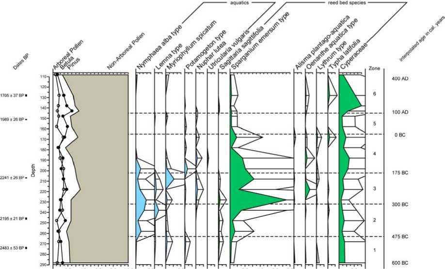
For the purpose of this publication, we only use summary pollen diagrams. Fig. 1 shows the ratio AP (Arboreal Pollen) / NAP (Non-Arbo-
ISSN 1818-7919
-естнЁ^ НГ”. —ерЁя: »сторЁЯ, Фёлоло„ёя. 2012. “ом 11, ,ыпyc^ 3: Археоло„ЁЯ ё этно„рафЁЯ © ¿. J. Kalis, A. Stobbe, 2012
14C-data profile «Weihe»
|
Laboratory |
depth (cm) |
age BP |
δ 13 C |
Cal 1 Sigma |
Cal 2 Sigma |
|
MAMS 11743 |
87–89 |
1578 ± 35 |
–24,2 |
433–534 AD |
410–560 AD |
|
MAMS 11741 |
127–129 |
1705 ± 37 |
–27,4 |
260–393 AD |
248–414 AD |
|
MAMS 10880 |
151 |
1989 ± 26 |
–22,7 |
36 BC–52 AD |
44 BC–66 AD |
|
MAMS 10881 |
207 |
2241 ± 26 |
–22,7 |
381–232 BC |
390–206 BC |
|
MAMS 11513 |
245–247 |
2194 ± 21 |
354–203 BC |
362–196 BC |
|
|
MAMS 11742 |
273–275 |
2483 ± 53 |
–25,6 |
762–524 BC |
776–414 BC |
Pollen diagram "Weihe" summary diagram and selected local polen types
20 40 60 80 100 20 20 20 40 60 80 20
Fig. 1. Profile «Weihe»: ratio AP (Arboreal Pollen) / NAP (Non-Arboreal Pollen) and the main components of the local vegetation
real Pollen), being indicative for the proportions of woodland versus treeless vegetation (e. g. steppe) and the main components of the aquatic and reed bed vegetation. They give information on the vegetation at the lake shore, which is highly sensitive to disturbances by the trampling of (domesticated) animals. Fig. 2 shows the three main components of the steppe vegetation (wormwood, grasses and cheno-pods) added up to 100 %.
Limnic sedimentation began around 600 BC and lasted for about four centuries. Then, at a depth of 210 cm, peat formation started and has continued until today. In the pollen diagram, however, only the period until 400 AD will be discussed.
Six pollen zones can be distinguished.
Zone 1 (288–263 cm) 600–475 BC
The pollen spectrum is dominated by Non-Arboreal Pollen (NAP). They reach about 80 % of the regional pollen sum and mainly represent steppe vegetation, with wormwood ( Artemisia
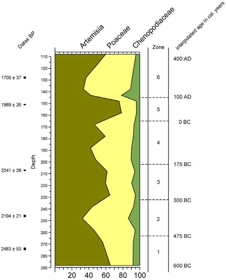
Fig. 2. Profile «Weihe»: the three main components of the steppe vegetation (wormwood, grasses and chenopods)
spec.), grasses ( Poaceae ) and chenopods ( Chenopodiaceae ). Arboreal Pollen (AP) is represented by pine ( Pinus , 10–13 %) and birch ( Betula , 7–9%). Moreover, there are single pollen grains of alder ( Alnus ), oak ( Quercus ) and elm ( Ulmus) . The local vegetation is hardly represented in the pollen spectrum of this pollen zone.
Zone 2 (263–232 cm) 475–300 BC
The AP/NAP-ratio remains the same, but the proportions within the steppe pollen types change. Wormwood decreases to its lowest level in favour of grasses and chenopods. Within the local pollen spectrum the increase of water lily (Nymphaea alba type) shows a transformation of the trophic level from the water into more mesotrophic conditions. Simultaneously the pollen curves of arrowhead (Sagit-taria sagittifolia) and burr reed (Sparganium emersum type) are increasing.
Zone 3 (232–202cm) 300–175 BC
With 35 % AP reaches its highest value, the pollen curves of the steppe indicators return to the values of Zone 1. Within the local pollen spectrum, aquatics increase to their maximum. Water lily (Nymphaea alba type) decreases whereas the yellow pond lily (Nuphar lutea) increases. The ultimate peak in burr reed (Sparganium emersum type) reflects the development of extensive burr reed vegetation along the lake shore.
Zone 4 (202–165 cm) 175–0 BC
AP decreases, pollen of steppe plants increases – especially grasses and chenopods. In the local vegetation a gradual decrease of the pollen values of aquatics and reed bed is perceptible. At the same time the pollen curve of sedges ( Cyperaceae ) increases.
Zone 5 (165–145 cm) 0 BC–100 AD
The AP/NAP-ratio remains the same, but the pollen values of Betula decrease and those of Pinus increase. Within the pollen spectrum of steppe plants, wormwood reaches its highest values, whereas grasses and chenopods fall back to their lowest level. The local vegetation is hardly represented in the pollen spectrum. No disturbance of the local vegetation is noticeable.
Zone 6 (145–100 cm) 100–400 AD
A sharp change is visible in the components of the steppe vegetation. The curves of grasses and especially from chenopods rise, and the curve of wormwood falls to the same level as in Zone 2. There is a strong rise of the pollen curve of sedges ( Cyperaceae ).
The vegetation pattern of Siberia is mainly determined by the macroclimate. In the TransUral and the Western Siberian lowlands the boundaries between vegetation zones are highly sensitive to minor climatic change. Small changes in precipitation, in length of the growing season or in summer temperature could provoke an extension of the steppe woodland towards the south, or an extension of the chenopod steppe in the northern direction. Comparable events could have happened in the valley of the Karagaily-Ajat with its well developed feather grass steppe, situated between the taiga in the north and the chenopod-steppe in the south. However, those susceptible ecosystems not only react on climatic change, but also on disturbances caused by human activities like animal husbandry or arable farming. There is much archaeological evidence of a strong human presence during the preceding Bronze Age [Koryakova, Epimakhov, 2007; Krause et al., 2010]. But unfortunately, in contrast to Early Iron Age settlements further north, no settlement and only a few barrows are known here from the subsequent Iron Age. Nonetheless it can be assumed that in the Iron Age as well, an utilisation of the feather grass steppe, at least as pasture, took place.
Thus, one of the central questions in revealing the vegetation history of the Trans-Ural steppe is whether the vegetational change registered in pollen diagrams was caused by climate or provoked by man and his livestock. To discuss this, it is necessary to know the primary natural vegetation and how it is reflected in the pollen rain. A study of the surface pollen samples of the present vegetation of southern Siberia [Pelankova et al., 2008] shows that the steppe has its own distinctive pollen spectrum which stands out against all other vegetation zones. Characteristics are: AP-values < 50 %, Artemisia > 17 % and Chenopodiaceae >1,3 %. Our own pollen surface samples from the steppe around Olgino corroborate that picture.
In the pollen diagram «Weihe» no section shows AP-values surpassing 40 %, neither Ar-temisia -values below 20 %, or Chenopodia-ceae- values below 2 % (fig. 2). According to the criteria of Pelankova et al. [2008] we can assume that the landscape around the Kara-gaily-Ajat was a wormwood-rich grass steppe between 600 BC and 400 AD. Like today, small patches of woodland were distributed on sites with more favourable groundwater conditions. In contrast to the studies by Zakh et al. [2008; 2010] in the Tobol-Ishim region, which indicate large scale landscape restructurings in the Subatlantikum, our investigations show no noticeable climatically driven shift of the vegetation zones in the period from approximately 600 BC until 400 AD.
Fig. 3 shows the recurrent change in the pollen values of Artemisia , chenopods and grasses within the steppe pollen assemblage. Climatic change has often been made responsible for this phenomenon, but other factors like pasturing should also be taken into account. Pasturing domestic animals exerts enormous influence on the steppe vegetation, as could be observed during the last century. Overgrazing, especially by sheep, has led to a large-scale and strong degradation of the natural steppe ecosystem, even to the point of its entire loss. Over-
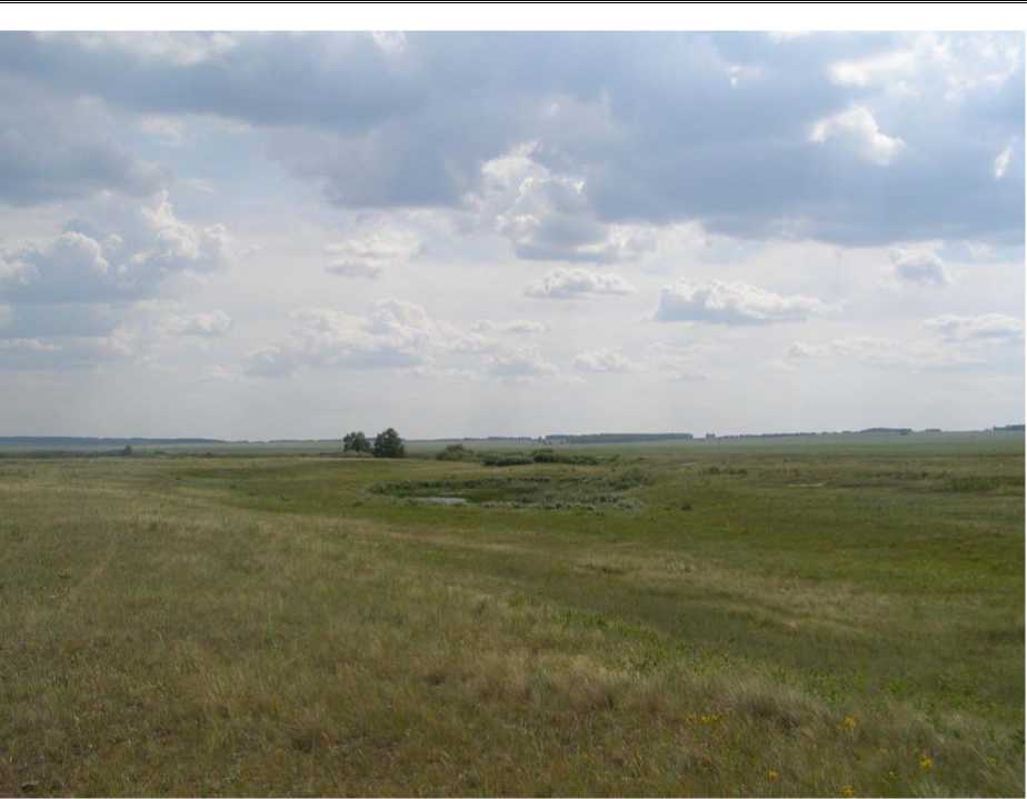
Fig. 3 (photo). Small pond surrounded by wet meadows in the floodplain
grazing is the chief reason for a loss of plant diversity, the opening of the plant cover and a change in dominance of the leading plant species. Grazing in a natural feather grass steppe leads in the first place to an increase of Artemisia . Other, more grazing resistant species of wormwood and also of grasses can spread. Increasing pasturing pressure also leads to the establishment of knotweed ( Polygonum avicu-lare ) and chenopod-species at the expense of wormwood [Liu et al., 2006]. Pasturing also has consequences on the aquatic vegetation, as soon as the animals use the ponds as watering place. First the shore vegetation will be trampled by animal hoofs. This results in the replacing of the natural sedge reed and reed bed vegetation by more trampling-resistant vegetation types like the arrowhead/burr reed vegetation (Sagittario-Sparganietum emersi) with arrowhead ( Sagittaria sagittifolia ), common water plantain ( Alsima plantago-aquatica ) and burr reed ( Sparganium emersum ) [Krause et al.,
2010]. As a consequence of watering animals the water pollution rises and we find a plant community with higher nutrient claims. Changes in the local pollen assemblage can therefore be used as evidence for the degree of pasturing.
During the period from 600 until 475 BC the valley of the Karagaily-Ajat was predominated by a wormwood feather grass steppe. At the sampling point of the «Weihe» profile a pond with open water was present, lined by a narrow sedge bed. No disturbance of the riparian vegetation is noticeable, although it has to be considered that wild animals could have used the pond as watering place. Around 475 BC a strong increase of grasses started and, to a lesser extent, also of chenopods. One can also detect first pollen grains from knotweed (Polygonum aviculare).This change of the vegetation suggests an increased level of pasturing. The rise of grass pollen values could imply an expansion of moist meadows near the site. These meadows, distributed on the flood plain along the river and created by grazing are the best and most productive feeding grounds for livestock (Fig. 3).
The local pond vegetation is changing concurrently. The increase of water lily ( Nymphaea alba type), documents a change of the trophic level to more mesotrophic conditions. The increase of the pollen curves of arrowhead ( Sagit-taria sagittifolia ) and burr reed ( Sparganium emersum type) shows the establishment of the arrowhead/burr reed vegetation ( Sagittario-Sparganietum emersi ), which points to trampling of the vegetation by livestock. The vegetation succession of the pond as well as the transformations within the steppe show a strong increase of the grazing pressure around 475 BC, probably caused by Iron Age Man and his livestock.
In the period from 300 BC to 175 BC, the pollen curves from Artemisia , chenopods and grasses behave more or less in the same manner as before (Zone 1). The immediate surroundings of the sampling site, however, show an even stronger disturbance of the reed bed vegetation than before. The burr reed pollen values reach their maximum. Water lily ( Nymphaea alba type) decreases whereas the yellow pond lily ( Nuphar lutea ) increases pointing to a further rise of the trophic level of the water from mesotrophic to eutrophic. Pasturing pressure on the Weihe site reaches its peak.
The strong increase of grasses and, to a lesser extent, also of chenopods at the beginning of zone 4, in combination with the local pollen assemblage, show renewed pasturing activity, but only for a short period. From about 100 BC on both the steppe plants and the local vegetation show a diminution of pasturing. The simultaneous increase of the pollen curve of sedges ( Cyperaceae ) is an indication that natural sedge reed with among others tufted sedge ( Carex elata ) could regenerate. During the first century AD signs of pasturing are at their lowest level. From the pollen analytical results one may conclude that hardly any human activities were left in the Karagaily-Ajat valley.
The next activity phase started around 100 AD with a strong decrease of wormwood and a brief but significant expansion of grasses and chenopods. Pollen grains of knotweed (Polygonum aviculare) and sorrel (Rumex spec.) appear once more and document renewed human presence. Anthropogenic activities even lead to the deposition of a thin sand layer in the deposit. Afterwards the sedge reed vegetation regenerated.
The above we presented the first results of new palynological studies in the Trans-Ural. It is an attempt to interpret the complex vegetation history of this area situated between steppe and taiga and between mountains and lowland. Our studies show that in this sensitive area climatic change alone is not sufficient to explain vegetational change and human impact should be considered to a greater extent. Our emphasis is to show the consequences of animal husbandry as explanation for the recurrent transformations in the vegetation development. Nevertheless, it should be stressed that this factor is not permissible to be seen as the one general explanation for ecological change.
АРХЕОПАЛИНОЛОГИЧЕСКИЕ ИССЛЕДОВАНИЯ В ЗАУРАЛЬЕ
