Automation and modulation of highways in GIS software

Author: Ergashev M., Mamajonov M., Kholmirzayev M.
Journal: Теория и практика современной науки @modern-j
Section: Основной раздел
Article in issue: 5 (59), 2020.
Free access
This article focuses on the creation of highway databases in ArcGIS, GIS (Geoinformation system) family software, working with thematic layers, creating and replicating attribute databases, database entry, and automated road modeling.
Scale, arcgis, cartography, cadastre, geodesy, electronic, digital card, state cadastre, state cadastre of highways, arccatalog, arcmap, app
Short address: https://sciup.org/140289580
IDR: 140289580 | UDC: 528.
Text of the scientific article Automation and modulation of highways in GIS software
Currently, there are a number of problems and shortcomings in the road management system of the republic that impede the creation of a competitive environment and investment in the sector. In order to create a modern road management system, clear control and economic functions, de-monopolization, attraction of private sector enterprises and increasing investment attractiveness, creation of a healthy competitive environment, broad implementation of innovations in road construction in 2017-2021. In accordance with the tasks of the Strategy of Action for the Priority, December 9, 2019 the President of the Republic of Uzbekistan Decree of the President of the Republic of Uzbekistan "On measures to further reform the road industry of the Republic of Uzbekistan" and the Resolution "On measures to further improve the road sector management system" we're passed. The legislation focuses on automation and modulation of roads, together with the State Committee for Land Resources, Geodesy, Cartography and State Cadastre of the Republic of Uzbekistan, Ministry of Transport, Council of Ministers of the Republic of Karakalpakstan, provincial and Tashkent city. system creation[1].
Materials and methods
Methods of comparative analysis, study and nationalization of foreign experience, studying and orientation of computer software capabilities, historical, logic and generalization methods were used in the article.
The main part
Development of modern road network, taking into account geographical location of the country, is the main task of increasing competitiveness of our economy, development of transport potential of the republic and expansion of export opportunities. Creation and modeling of automated databases are designed to improve road infrastructure, build modern highways, and improve road comfort and safety [3].
Work on automation and modulation of highways consists of the following main components:
-
- Determining the location of highway facilities using the mobile application of geoinformation systems;
-
- Creation of electronic cartographic basis of highways based on remote sensing of the earth;
-
- Registration and registration of automobile roads using the single electronic database of national roads
-
f ormation of a web geo information system of the State Cadastre of Highways;
-
- Integration of the web geo information system of the State Cadastre of Highways into the Uniform System of State Geographical Data Banks (Cadastre) [2].
In accordance with the Decree PQ-2045 "Establishment of National Geographic Information System" of the President of the Republic of Uzbekistan a number of reforms were implemented in the country. Conducting and forming 21 state cadastres in the territory of the Republic of Uzbekistan Regulation on the procedure for creating and maintaining the Unified System of State Geographical Data Banks approved by the Cabinet of Ministers # 66 on February 16, 2005 and Cabinet of Ministers 14 According to the decision № 431 «On approval of the Regulation on the procedure for maintaining the state cadastre of regions», the State Committee on Geodesy and Cartography chaste assigned to the National Center for State Unitary Enterprise[7].
The 1:10 000 electronic digital card is a cartographic basis for the maintenance and formation of the state cadastres. In accordance with the Regulation “On the composition and the procedure for submitting state cadastre data to the Uniform System of State Cadastres” registered by the Ministry of Justice on October 8, 2014, the State Committee “Uzavtoyul” is responsible for maintaining and forming State Road Cadastre. Data on GIS on GDRT are formed in ArcGIS software (* .shp, * .gdb, * .mdb) on objects and types of information using the base cartographic basis for each type of the state cadastre[6].
Database formation during automation and modulation of highway geoinformation system is carried out in the order set forth in Table 1 below.
Table 1
Sequence
Photo caption
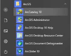
Press the Start button to select ArcCatalog row from ArcGIS
Содержание Просмотр Описание
ИмяТ
|W] avtomobil_yollariГ
[*■'] bino_inshootlariГ himoya_inshootlariГ
1^1 suniyinshootlarГ
I*-*] ta rti b g a_kelti ri sh_va_j i h ozl a sh_o... Г
1^1 у о11 a r_c h о rra h a I a ri_va_tuta s h uv... Г
ArcCatalog tree selects the required memory disk and creates a database, a "low class" and thematic layers
Due to changes in the quality and technical characteristics of the highways, regular upgrading of the electronic card is required. The process of updating and identifying changes to an electronic digital card is based on the results of fieldwork and integrated into the database[8].
Formation and updating of electronic digital cards is as follows this is done in the manner described in Table 2.
Table 2.
Sequence
Photo caption
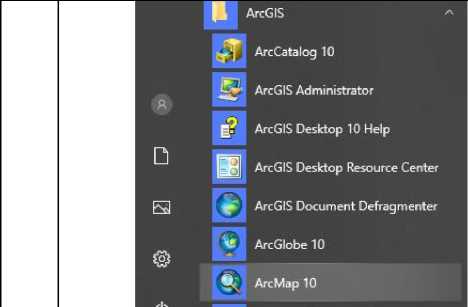
“Press the "Start" button to select
ArcMap in the ArcGIS field
Existing files from ArcMap will be opened and field data will be added to or modified from the database
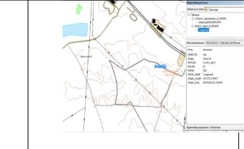
In accordance with the above procedures, a database of manufacturing organizations should be formed. The process is mechanically updated each season, using ArcMAP software ArcMAP (Figure 1). In addition, the visual information is incomplete because the objects of the state cadastre of highways do not consist only of the road itself. Highways consist of the following thematic layers:
-
- - Overview of highways;
-
- - Highways;
-
- - Artificial structures;
-
- - Arrangements and equipment;
-
- - Crossroads and intersections;
-
- - Protection structures;
-
- - Buildings and structures.
RESULTS
High efficiency can be achieved through automation and modulation of this process. A GPS device for field research ArcGIS requires coding (Figure 2) or electronic taximeters (Figure 3). The GPS data includes the following information[9]:
-
- Road Name,
-
- Identification number,
-
- Kilometers,
-
- Office affiliation,
-
- Date of commissioning,
-
- Classification by significance,
-
- Classy,
-
- Location,
-
- Category,
-
- Intensity of movement,
-
- Positive speed,
-
- Number of bands,
-
- The type of the terrain,
-
- Type of pavement,
-
- Type of coating,
-
- Availability of pavement layers,
-
- Last Reconstruction Date,
-
- Reconstruction rate,
-
- Balance value.
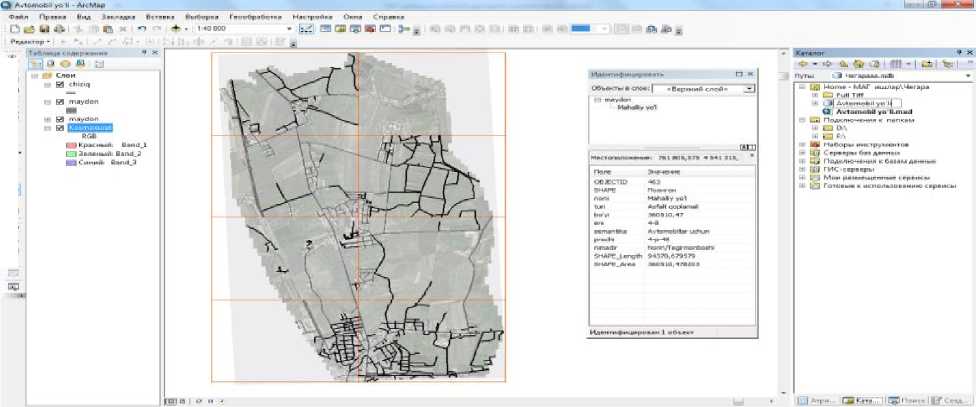
Figure 1. ArcMap working window
Field and cameral research using GPS and ArcGIS software are performed in the following order:
-
- With the help of GPS, road objects are surveyed in the field,
-
- All information received in the location is entered in the device
attribute table,
-
- “Project” data is sent to processing centers,
-
- Taking information from the centers and entering them into the
database,
-
- Each layer is associated with the corresponding data.
The measurement data obtained from an electronic taximeter is also processed using ArcGIS software and integrated into the automated databases. The results of this electronic taximeter survey can also be used as a topographic basis[10].
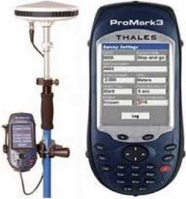
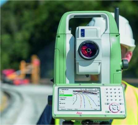
Figure 2.GPS device
Figure 3 Electronic taxeometer
ArcGIS allows you to integrate themed data and integrate data with the command "Class connection..." and to implement an automated land management system. Providing the direct access of GPS information to the database will help to automate the automated system .
CONCLUSION
Currently, GIS is widely used in all sectors of the economic and technical sectors. The use of GIS requires the collection, storage, processing and delivery of large volumes of written, graphic, and geographical boundaries.
By modulating the automated highway system, we will achieve the following benefits:
-
- Increasing the use of modern techniques and technologies;
-
- High accuracy results;
-
- Short-term exchange of information;
-
- Increase of efficiency of work;
-
- Electronic data interchange;
-
- Database systematization.
ACKNOWLEDGEMENTS
We thank Q.Inoyatov, research director and N.Ergasheva, who helped to translate the text into English.
References Automation and modulation of highways in GIS software
- Strategy of Action on five priority areas of development of the Republic of Uzbekistan in 2017 - 2021.
- The Decree of the President of the Republic of Uzbekistan "On Measures for Deep Reformation of the Road System of the Republic of Uzbekistan".Tashkent-2019.
- Resolution of the President of the Republic of Uzbekistan "On Measures for Further Improvement of the Road Sector Management System". Tashkent-2019.
- The Decree of the President of the Republic of Uzbekistan "On the Establishment of National Geographic Information System". Tashkent-2013.
- Regulation "On the procedure for establishing and maintaining a single system of state cadastres" approved by the Cabinet of Ministers of the Republic of Uzbekistan on February 16, 2005 № 66.
