Cadastral investigation оf Shuiquan town in Tuquan county

Author: Sudubilige , Erdemtu Jin , Yuhai Bao , Yulong Bao
Journal: Природа Внутренней Азии @nature-inner-asia
Section: География
Article in issue: 4 (13), 2019.
Free access
The development of economy and society imply high requirements for cadastral management. Computer technologies and the development of geodesy and mapping allowed people to meet such high requirements for cadastral management, thus the theory and practical technology of cadastral survey and cadastral data management has been developed. Taking the cadastral survey project of Shuiquan Town in Tuquan County as an example, we introduce the cadastral survey, ownership investigation, plane control, database construction and quality inspection in all the administrative villages except the township government. This project is aimed at studying the process of rural homestead investigation, making the future work more standardized, and having an overall understanding of the whole work.
Database, arcsde, arcgis, cass
Short address: https://sciup.org/148317156
IDR: 148317156 | UDC: 631.5(510) | DOI: 10.18101/2542-0623-2019-4-100-108
Кадастровое исследование города Шуйцваня в округе Туцюань
Развитие экономики и общества предполагает высокие требования к кадастровому управлению. Компьютерные технологии и развитие геодезии и картографирования позволили практически реализовать эти требования, в результате чего сформировалась теория и практические технологии, связанные с кадастровой съемкой и управлением кадастровыми данными. В статье на примере проекта кадастровой съемки города Шуйцюань в округе Туцюань представлены кадастровая съемка, расследование прав собственности, контроль над самолетом, построение базы данных и проверка качества во всех административных поселениях, кроме городского управления. Этот проект предназначен для изучения процесса исследования сельских приусадебных участков, стандартизации будущей работы, составления общего представления о ней.
Text of the scientific article Cadastral investigation оf Shuiquan town in Tuquan county
Project Task and Survey Purpose
Project Task
With the approval of the People’s Government of Tuquan County, the Land and Resources Bureau of Tuquan County cooperated with the Land Survey and Planning Institute of Hinggan League to jointly complete the registration of rural land rights and the establishment of a database in Shuiquan Town, Tuquan County.
Purpose of Rural Cadastral Survey
The purpose of the cadastral survey is to obtain basic information such as the location, ownership, boundaries, quantity, use, and grade of each land, and to provide evidence for land registration. Cadastral survey is a substantial investigation in land registration to determine land ownership and clarify property rights. The results of the investigation are important evidence for protecting the legitimate rights of landowners and land users and resolving land property disputes. At the same time, the cadastral survey also can grasp the land type, quantity, distribution and utilization of a region, as well as the distribution of land among various economic components and among various departments of the national economy. It provides information guarantee for the establishment of scientific land management system, the rational use and protection of land, the realization of dynamic balance of total cultivated land, the regulation of land supply and demand, and the standardization of land market.
The Survey Area
Geographic location
Shuiquan town is located in the east of Tuquan county, in the transition zone from the shallow hills to the plain, 22 kilometers west from Tuquan Town, 80 kilometers east from Taonan County, Jilin Province. Tutao road cross the town, it has convenient transportation and developed trade, and is one of the important export towns in the whole region.
Administrative divisions
Table 1
1 3 villages under the jurisdiction of Shuiquan Town
Town Village
Shuiquan 、 Hefa 、 Xingsheng 、 Shenghuan 、 Shen
Shuiquan Town gquan、Longquan、Longsheng、Tuanjie、Dequa n、Lianhe、Yongquan、Xiaopaozi、Guanghui
Inner Mongolia Administrative Boundary Map
™
110WE 120°0D"E
Fig. 1. Location of the survey area
Archival.Arrangement ' binding' placeonfik
Registration and certification database
Spot
Investigation Of Ownership investigation
Unqualift-
Ex amination and confirm ationm aterial
L and certification
List of Receipt
Approval form
Registrationcard
Qualify
И1 out the cadastral form
В oundary interpret
Survey and registration into databa se
Registration and certification Make matenal
Propa^nda 'Business training
Work base map
Database construction
Issue of demarcation notice
C a dastral Survey
Use of CASS Draw-
Data collection
Preparationforwork
Inspect' -Acceptance
Land certificate
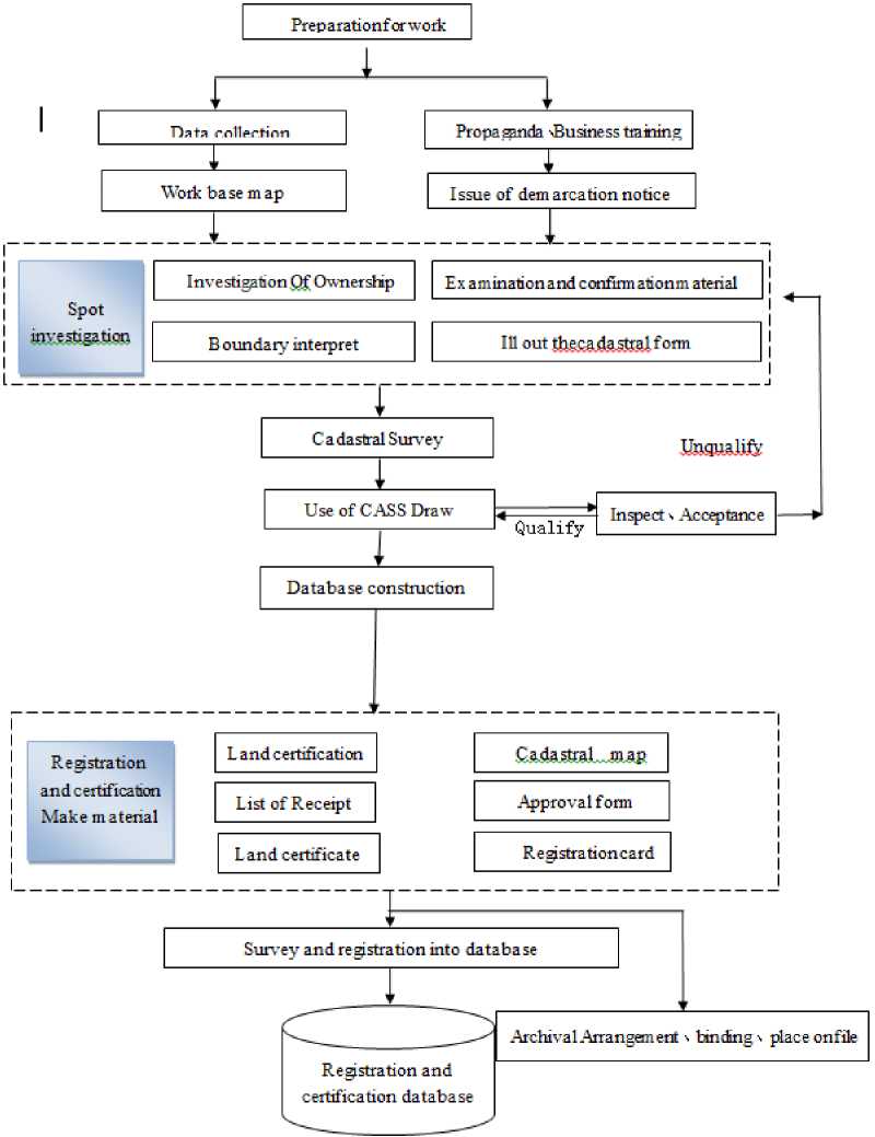
Fig. 2. Technical flow chart
Rural Cadastral Survey
Technical route
Focusing on the overall goal of the cadastral survey, the rural homestead survey of
Shuiquan Town in Tuquan County is based on the unified national land use classification standards, survey contents, investigation technical methods and processes, combined with the actual situation of Shuiquan Town, makes full use of the existing land survey results, and converts the existing data results in coordinate system. By using the global satellite positioning, geographic information system, database and network communication technology, through the comprehensive investigation means of internal interpretation, field investigation and verification, data collection and processing, the technical process of homestead investigation is formed, which integrates information acquisition, processing, storage, transmission, analysis and application services.
Ownership survey
Homestead ownership survey refers to the investigation of land ownership source and rights of homestead owners or users, the homestead location, boundary, area and use. The boundary point and boundary line of the land ownership of the homestead are plotted on the survey base map or the land use status map, which is identified by the landowner or user as the basis for registration and certification.
The technical requirements
-
(1) Surveying and mapping the base map
According to the survey scope, large scale digital status map measurement (1:500) was first completed, and main topographic elements were mapped and taken as the base map of the ownership survey.
-
(2) Acceptance of application documents
The application for land registration and the supporting documents of power source are the basis for carrying out the ownership investigation. The proof of homestead right source refers to the proof material of obtaining the right to use homestead legally. The investigation team shall check and count the application documents.
-
(3) Division and coding of districts, streets and neighborhoods
The districts shall be arranged with one letter code, and the first phonetic capital letter of the first Chinese character in the current administrative region is used as the letter code, which shall be corresponding to the 6-digit character code specified in the code table of national administrative divisions when building the database. According to the jurisdiction of the current administrative street, the street code is encoded by the method provided by the administrative division code. The street code is only used as a statistical summary, not as a part of the formal cadastral number. The neighborhood is divided into natural linear objects such as roads and rivers, which are relatively stable. The 2-bit digital code is used to compile the neighborhood number from «01». The neighborhood code is used as a part of the cadastral number. In principle, the original neighborhood division and numbering are used in this update.
-
(4) Parcel number and obligee code
The parcel code adopts 3-bit digital code, which is arranged according to serpentine from «001» in each village.
-
(5) Cadastral numbers
The cadastral number consists of «district code + administrative village code + parcel code». The district code is one-letter code, the neighborhood code is two-digit code, and the parcel code is three-digit code.
-
(6) Classification of land use
The classification of land use adopts the land classification standard “National Land Use Classification” promulgated in 2001, which is mainly based on land use. For a land with multiple uses, one of the main uses is the category of the land.
Parcel map
-
(1) Basic accuracy requirements for boundary points
Table 2
Basic accuracy requirements for boundary points
|
Medium error of the boundary point relative to the point of the adjacent map root |
The allowable error of the distance between the boundary point and the adjacent ground point (cm) |
Scope of application |
|
|
Medium error (cm) |
Allowable error (cm) |
||
|
±5 |
±10 |
±10 |
The outer boundary point and the internal obvious boundary point of the town neighborhood |
|
±7.5 |
±15 |
±15 |
Hidden boundary point in urban neighborhood |
-
(2) Polar coordinate and intersection method can be used in surveying and mapping boundary points.
-
(3) All the boundary points on the periphery of the neighborhood and the obvious boundary points inside the neighborhood should be set up at the control points above the map root or the map root, and measured by polar coordinate, ranging not more than 150 m and measuring distance not more than 50 m.
-
(4) When the inner boundary point of the neighborhood is measured by the branch wire method, the total length is not more than 100 m, and the root point to the boundary point should not exceed 3 sides.
-
(5) For any boundary point measured by analytical method, the first and second types of errors in side length and measured side length shall not exceed 10 cm and 15 cm, 5 cm and 7.5 cm, respectively.
-
(6) The location of the boundary points on the map should be consistent with the sketch of the plot and the actual situation within the specified precision. The boundary line should be strictly on the line of the corresponding boundary point, when the edge length of the boundary is shorter than 0.3 mm on the map, only one point is indicated; when the edge length of the boundary is less than 0.8 mm, the boundary is not drawn; When the edge length of boundary point is longer than 0.3 mm and shorter than 0.8 mm, the overlapped circle of boundary point symbol is not drawn. When all kinds of linear features coincide with the boundary line, only the boundary line is drawn. When the administrative boundary line coincides with the boundary line, the boundary line is bounded on both sides.
Area summary statistics
The parcel area calculation is automatically performed by the Southern CASS7.1 software, and the formula is as follows:
nn
-
p = 7 Z X i (Y . 1 - Y - i W = Z Y ( xm - X i . 1 )
21 21
Cadastral map
The scale of the cadastral map of Shuiquan Town in Tuquan County is 1:1000, the coordinate system adopts the 1980 Xi’an coordinate system, the elevation reference adopts the “1985 National Elevation Reference”, and the map projection adopts «gauss-kruger projection». The spatial reference, data set accuracy, topological tolerance value, central meridian, and zonation are consistent with the standards of secondary survey database. The basic unit of length of the data results is meters, and the basic unit of area is square meters. The coordinate result data retains 3 digits after the decimal point. The length and area data are kept 2 digits after the decimal point.
Boundary point results
Table 3 Boundary Point Results
|
Boundary Point Results |
||||
|
Parcel No : SL21—4—8—46 |
||||
|
Parcel name : Jinshui Song |
||||
|
Parcel area (m2) : 1381.88 |
||||
|
Boundary point coordinate table |
||||
|
Serial No. |
Point No. |
coordinate |
Side length ( m ) |
|
|
X(m) |
Y ( m ) |
|||
|
— |
||||
|
1 |
||||
Automatically generated boundary point results table contains boundary point, serial number, boundary point coordinates, boundary line length and land area.
Entry of cadastral attributes
Using the Southern CASS7.1 software, the parcel attribute, the boundary point, and the boundary line attribute are entered into the database and the attribute information is loaded into the graphic data to automatically generate the cadastral survey electronic form.
Data storage
Before data storage, according to the requirements of the “Land Use Database Standards” and the “Second National Land Survey Database Construction Technical Specifications”, comprehensive quality inspection shall be carried out on the data, and qualified data shall be put into storage. The rural land survey database of Shuiquan Town, Tuquan County was built using the “Village Cadastral Management Information System” GIS software of Nanjing Guotu Company.
Application software and database system
The « Rural Cadastral Management Information System « GIS software is developed based on ArcGIS in Nanjing Gutu Information Engineering Co., Ltd. The system uses the large database of Oracle ArcSDE as the data storage and management platform. ArcSDE is the spatial data engine of ArcGIS, which is the path to store and manage multi-user spatial database in relational database management system. ArcSDE uses a client/server architecture.
System architecture
The rural homestead survey of Shuiquan Town in Tuquan County adopts ArcGIS platform. The combination of its spatial database engine SDE with Oracle, SQLServer and other large databases is the first choice of large spatial database solution, which can realize the integrated management of spatial and non-spatial, vector and raster data. The database platform adopts Oracle 10g and Microsoft Access (Personal Geodatabase) database, and uses ArcSDE as a spatial data engine for spatial data invocation and management, supporting multi-user and concurrent operations.
The application system in the C/S part is developed by ArcEngine component, which includes the desktop application system and the network application system. C/S: Client and Server are usually located on two computers that are far apart. The Client program’s task is to submit the user’s requirements to the Server program, and then display the results returned by the Server program to the user in a specific form. The task of the Server program is to receive the service request put forward by the Client program, conduct corresponding processing and then return the result to the Client program.
Data requirements
-
(1) using Gauss-Kruger projection and 1980 Xi’an coordinate system;
-
(2) the vector data is Personal Geodatabase (MDB) format data supported by ArcGIS;
-
(3) the attribute table is complete and the element content is correct;
-
(4) The attribute table and field are named correctly, and the format and content meet the requirements.
Quality inspection
-
(1) Quality inspection
-
(2) Data standard inspection
-
(3) Feature topology check
-
(4) Data attribute check
-
(5) Consistency check of graphics and attribute data
Conclusions
-
(1) By carrying out the registration and certification of rural land rights in Shuiquan Town, Tuquan County, the ownership, location, boundary, scope, use and area of collective land ownership, house site use rights, collective construction land use rights and state-owned land use rights are confirmed according to law. In accordance with the principle of “clear property rights, control of use, economical use, strict regulation”, the rural land management system will be further improved by the national land department.
-
(2) Through the establishment of rural cadastral management information system, the cadastral services can be gradually digitized, networked and automated, and it can be fully supervised in advance, during and after the event, and real-time update and resource sharing can be realized.
-
(3) The application of ArcGIS and other software makes the work more perfect and simple.
References Cadastral investigation оf Shuiquan town in Tuquan county
- Specification for Digital Mapping 1:500, 1:1000 and 1:2000 (GB/ t20257.1-2007), 2007. Zhenghang Li, Jinsong Huanr. Principles and Applications of GPS Measurement. Wuhan University Press, 2005
- Changgen Zhan. Cadastral Survey. Wuhan University Press, 2005
- Jufacr Li, Jie Zhao. Topographic Survey. Yellow River Water Conservancy Press, 2004. Qizjin Qin. Application of Digital Technology in Cadastral Mapping. Guangxi Geology, 2001
- Hengchang Gao, Zhaohui Dum, Zhttg Peng. Application of Digital Mapping in Urban Ctdtststl Survey. Urban Survey, 2002
- Cadastral Survey Specification (CH5002-94). Beijing Press; Surveying and Mapping Press, 2001. Changbin Wu. Research on Integrated Urban and Rural Cadastral Information System. Nanjing Normal University, 2002
