Chronology of the historical context of Maragheh city based on archaeological exploration and historical written sources

Author: Sattarnejad S., Parvin S., Hendiani E.
Journal: Краткие сообщения Института археологии @ksia-iaran
Section: Города и фортификации
Article in issue: 260, 2020.
Free access
Maragheh, located in the northwestern geographical area of Iran, is one of the important areas in the studies of Islamic period of Iran. The name of the city has been mentioned many times in various historical sources and is most often referred to as the seat of the Azerbaijani state. But information on its history and background is very limited, because it has been so far neglected from an archeological point of view. Only few historical and archeological studies have generally addressed the status of formation and sequence of its historical periods. This article presents the results of new archaeological excavations and study, the purpose of this research is mainly attempted to provide a detailed chronology of the status of residence and settlement in the central part of the city by presenting a detailed stratigraphy of cultural materials of different historical eras and adapting them to historical events. The results, obtained in archaeological studies of the historical context of the city, show that the settlement in this part of the city has been started without interruption since the beginning of Islam.
Maragheh city, archeological excavation, cultural sequence, historical sources
Short address: https://sciup.org/143173155
IDR: 143173155 | DOI: 10.25681/IARAS.0130-2620.260.397-406
Text of the scientific article Chronology of the historical context of Maragheh city based on archaeological exploration and historical written sources
Maragheh city is located on the southern slopes of the Sahand Mountain in the northwestern part of Iran. Although historically considered as one of the most famous cities in the state of Azerbaijan ( Ibn Khordadbeh , 1889. P. 124, it has been so far neglected from an archeological point of view. For this reason, information on its history and background is very limited. The city of Maragheh has had a favorable location for the formation and expansion of a city both climatically – geographically and communicatively, and evolved in different cultural periods that eventually led to the formation of the city of Maragheh.
One of the problems with Maragheh chronology is the lack of archaeological evidence. This problem arises from the fact that prior to the present study, the research program aimed at studying the historical context of Maragheh had not been carried out, and few historical and archeological studies have generally addressed the status of formation and sequence of its historical periods. Accordingly, with the archaeological excavation of the curtain area ( Rahmatpour , 2019) and its adaptation to the historical written sources, the status of the chronology of the historical context of Maragheh has been clarified to some extent. Therefore, the present article attempts to present the results of archaeological excavations of enclosure and to use the scientific chronology of this city.
Research Methodology
This paper mainly uses field method which includes archeological excavation. For archeological study, the subject of the research was prepared at the beginning of the site topographic map and the desired trenches were identified at that location. Hence, 10 trenches of different size were created in this part of the enclosure. Trench «I» was considered as the stratigraphic trench. The method of recording was very important. Therefore, the Locus-Locus method was used for exploring the cultural layers of Trench I as a way that by changing the nature, appearance and perceptual characteristics of the accumulations and deposits or cultural phenomena, each of them was assigned a unique number called Locus. Library studies, especially sources from the 3rd to 10th centuries AH, were also used to match the results of the archaeological excavations.
Geographical location and historical events of Maragheh
Maragheh is located in the northwestern part of Iran on the southern slopes of Sahand Mountain. The most important factor in the formation of the city is the permanent flow of Sufi Chay River (fig. 1). The river originates from the southern slopes of the Sahand Mountain and numerous monuments of various historical eras has formed on its periphery. According to local narratives, the date of Maragheh’s formation dates back to pre-Islamic times, and a study of historical written sources from the 3rd and 4th centuries AH shows that Maragheh was a small village in the Azerbaijani province in the early Islamic period ( Balazari , 1989. P. 463). Due to the geographical location of the communication route, this city has progressed gradually, and in the Middle Ages it was chosen as the capital of the Atabegs of Azerbaijan (Eldiguzids) and Ilkhanids ( Mostofi , 2002. P. 134).
The most important period of residence in Maragheh dates back in the 7th century AH. It is said that during this period the Mongol Ilkhanids chose the city as their capital ( Ibn al-Fuwati , 1996). During this period, some of the tax revenue was spent on science in Maragheh, so that the largest and most important observatory of the Middle Ages of Islam was established in this city at the behest of Nasir al-Din al-Tusi ( Nasir al-Din al-Tusi , 1989. P. 20). After this glorious period, Maragheh
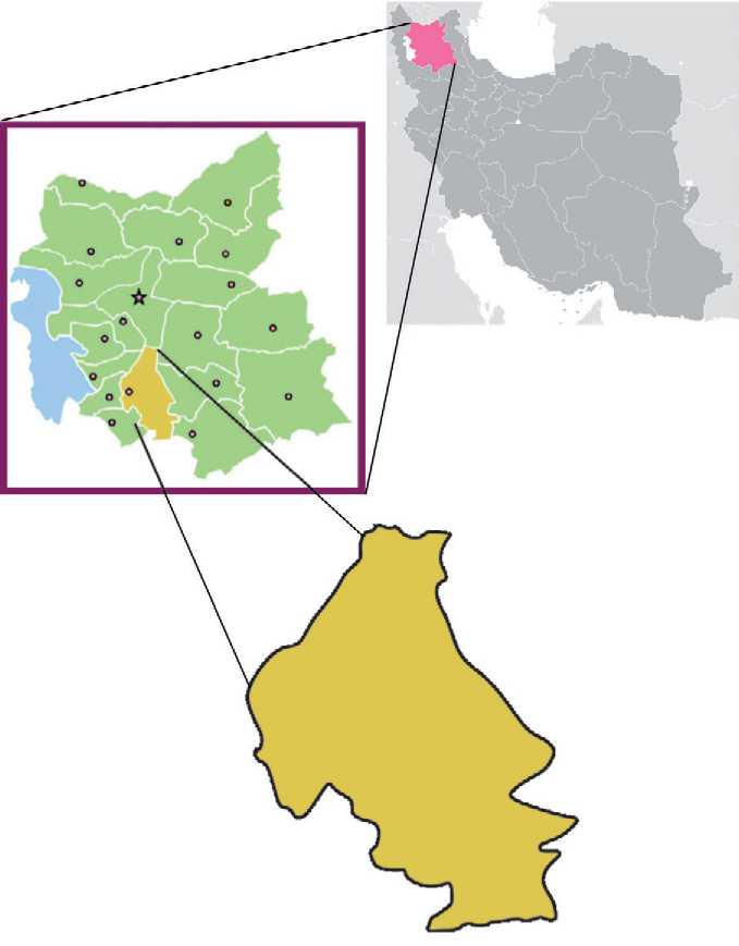
Fig. 1. Maragheh’s geographical location (Authors)
became one of the most important cities in northwestern Iran. Different works of different historical periods has been left in this city that indicate Maragheh’s important position in Iranian historical developments. Archaeological studies and investigations evidence settlements of different historical periods in Maragheh. During archaeological excavations concerning the historical context of the city, information was obtained on the status of settlement in different historical periods. The stratigraphy formed in the historical context identifies the status of the cultural periods of the city, which is consistent with some of the historical events mentioned in the historical texts.
Stratigraphic Trench
Trench «I» was selected as an archaeological sounding 1.50 m long and 1 m wide in the west side of tomb tower No. 3 and in the cutting slope of the northwest corner of the patio area with a relatively good accumulation for stratigraphy. After threading of 4 corners of sounding, the southwest corner of the trench was considered as a fixed point (A) and the other corners were labeled point B in the northwest corner, point C in northeast corner and point D in southeast corner respectively following clockwise motion. Excavating the archaeological layers of this sounding was the same as locus (Loc. 101–128). The trench was arranged as a staircase to the north slope of the enclosure with the purpose to obtain information concerning the layers within the enclosure bed, which is essentially the only Maragheh circular stratigraphic trench. After documenting the trench surface, excavation and stratigraphic recording was initiated and 128 locus were identified and documented in the course of excavations. Due to the expiry of the excavation time, the exploration work in Sounding I remained uncompleted, and therefore the top-down layer numbering continued from 101 (surface soil) to 128 respectively, with the last identified locus at 580 cm of depth. Each identified locus has a different structure, texture, quality, and color (fig. 2). The following table describes each locus (tabl. 1).
The study of the layers excavated in the stratigraphic trench shows that from locus 120 to 101, the habitation in this part of the city continued uninterruptedly. The layers are of medium thickness, and the cultural materials derived from these layers are mainly clay fragments, broken bricks, and turquoise colored tile pieces. At this trench, at layer 115 and -330 cm of the highest trench level, there is evidence of a fire that may have been associated with the events of 11th century raids. During this period, Maragheh was attacked by nomadic people and part of the city’s buildings, including jama masjid of the city, were burnt down ( Ibn Asir , 2006. P. 5629). After this event, Maragheh becomes less troubled and the relative calm prevails in the city. The explored cultural layers also indicate the tranquility of this part of the city.
Table 1. The descriptions of locuses
|
Locus number |
Locus Explanation |
Depth of start and end of locus |
Locus cultural data |
|
101 |
Surface layer of the enclosure |
0 to 20 cm |
Pottery, Brick, Contemporary Materials |
|
102 |
Stone wall |
20 to 90 cm |
Structure of Cobble with lime mortar |
|
103 |
Clay accumulation |
20 to 100 cm |
Pieces of earthenware and broken bricks |
|
104 |
Accumulation of clay and lime |
90 to 120 cm |
Bricks and Tiles |
|
105 |
Pit |
120 to 135 cm |
--------- |
|
106 |
Accumulation of soil and ash |
122 to 137 cm |
Bones, Earthenware, bricks and ashes |
|
107 |
Clay accumulation |
137 to 200 cm |
Earthenware, tile, bone |
|
108 |
Accumulation of clay saturated with lime |
200 to 250 cm |
Earthenware and broken bricks |
|
109 |
Clay accumulation |
250 to 266 cm |
----------- |
|
110 |
Clay accumulation |
268 to 293 cm |
Earthenware |
|
111 |
Accumulation of fly sand and ash |
293 to 300 cm |
Coal |
|
112 |
Clay and fly sand |
300 to 317 cm |
----------------- |
|
113 |
debris |
317 to 322 cm |
Broken pieces of wood |
|
114 |
Remained debris |
322 to 330 cm |
--------------- |
|
115 |
Ash |
330 to 350 cm |
Coal |
|
116 |
River sediment |
350 to 356 cm |
--------------- |
|
117 |
Heated texture |
350 to 355 cm |
Earthenware |
|
118 |
Clay accumulation |
317 to 356 cm |
Earthenware |
|
119 |
Ash accumulation |
357 to 365 cm |
--------------- |
|
120 |
Clay accumulation |
360 to 420 cm |
Complete broken pottery |
|
121 |
Silty soil accumulation |
420 to 435 cm |
--------------- |
|
122 |
Debris? |
435 to 444 cm |
--------------- |
|
123 |
Fly sand |
444 to 455 cm |
--------------- |
|
124 |
Fly sand and silty soil |
455 to 460 cm |
--------------- |
|
125 |
River sediment |
462 to 473 cm |
--------------- |
|
126 |
Sand and clay |
474 to 490 cm |
--------------- |
|
127 |
Clay, sand and lime |
490 to 520 cm |
--------------- |
|
128 |
Clay and lime |
521 to 580 cm |
Piece of Earthenware |
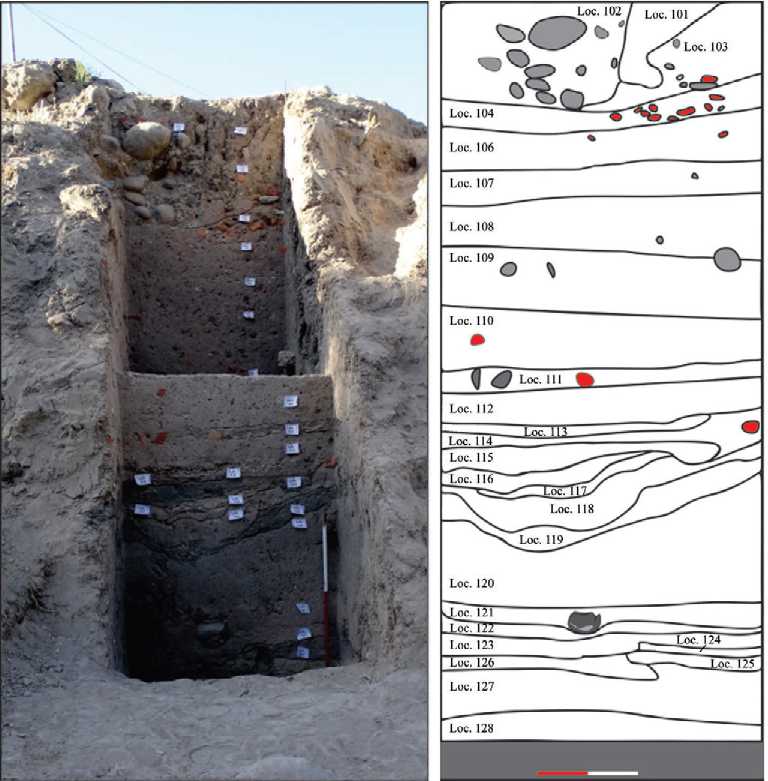
Fig. 2. Trench I (after Rahmatpour , 2019. P. 158) a (brown) – stone; b (red) – brick
Earthenwares of Trench 1
The pottery obtained from the cultural layers is glazed and non-glazed. The earthenware of lower layer was largely glazed and it seems to be the earthenware type of historical periods of northwestern Iran. Islamic glazed earthenware consisted of turquoise black pen, blue and white, simple monochrome glazed pottery and multi-colored glazed painting, Sultan Abad’s style pottery, sgraffitto pottery, and Aghkand. Sgraffitto and Aghkand potteries dated back to 6th century until the end
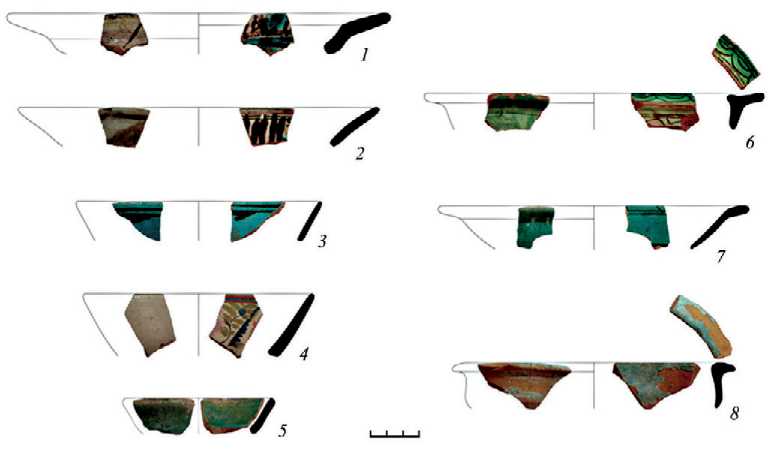
Fig. 3. Some earthenware from Trench I (after Rahmatpour , 2019. P. 165)
of the 8th century AH ( Mahjour, Sediqian , 2009. P. 111) and turquoise black pen to 6th century AH ( Allen , 2004. P. 37; Rice , 1997. P. 76). The prevalence of T-shaped edges is mainly related to the second half of the 7th and 8th centuries AH ( Khalili , 2006. P. 162). Also, multi-colored under-glazed potteries are mainly considered of the Ilkhanid period ( Atil , 1973. P. 59; Hall , 1934. P. 66). Based on the evidence and comparative research, Maragheh’s bruise and circular potteries can be attributed to the Islamic Middle Ages and similar examples in areas such as Varamin ( Chubak , 1997. P. 54), Neyshabur ( Wilkinson , 1973. P. 280), Jorjan ( Bahrami , 1988), Meshkin Tappeh of Zarandieh ( Mahjour, Sediqian , 2009. P. 119), Arzan Fud of Hamadan ( Zarei et al. , 2014) has been identified (fig. 3).
Matching the cultural layers of the stratigraphic trench with historical events
The formation of historical layers in an ancient site is in fact the socio-cultural elements and past history of a region. Archaeological studies of the cultural layers of the historical context of Maragheh show three distinct historical periods in the Iron Age, Parthian-Sassanid and Islamic periods, respectively.
The Maragheh region, which formerly included the cities of Maragheh, Bonab, Hashtrood, Ajabshir, Malakan, Takab and Shahin Dej, has witnessed cultures such as local culture, Urartu, Mana and Assyria in the Iron Age. According to the Assyrian inscription of Sargon II (714 AH), at this time, the area was more commonly known as «Osh Dish» (Luckenbill, 1927. P. 84). The current location of Maragheh was also affected by these affairs, and cultural materials, especially earthenware fragments in the lower layers, which largely lack permanent settlement, have been identified.
The second period of cultural layers of Maragheh’s historical context mainly belongs to Parthian and Sassanid culture. During this period, Maragheh was part of the Parthian Empire (later called the Semi-Independent Atropates) and later Sassanid. During this period, the central role was played by areas such as the Zahhak Castle of Hashrood, more commonly known as the Parthian city of Fraspa ( Kleiss , 1973. P. 168–184), Qizlar Qaleh Si, Bakhtak Castle and Dash Qaleh. During this period, it seems that the current city of Maragheh did not have an important position and the settlement was represented by a small village. Based on the historical sources of the 3rd and 4th centuries AH, Maragheh’s name was in the form of Aqare Day and Afare Day in the late Sassanid and early Islamic period ( Balazari , 1989. P. 463).
The third period of residence in Maragheh is related to the Islamic era. We are witnessing the development of Maragheh in this period. At this time, with the increase of population, Maragheh became a city and gradually became a seat of northwestern Iran (Azerbaijan). The presence of consistency in the cultural layers of the city’s historical context reflects the magnificent era of Maragheh (tabl. 2).
Table 2. Cultural Periods of South of Sahand and Maragheh City based on Archaeological Excavation Results
|
Cultural period |
Historical considerations |
Average depth of cultural material in the historical context of the city (B.M: Floor of Tomb Tower of Kabood) |
Key enclosures of the area |
|
Islamic |
Residence of Islamic Army in Maragheh, capital of Maragheh during Atabakan Seljuk period, Ilkhani |
450 cm |
Current Maragheh |
|
Parthian – Sassanid |
The semi-independent rule of Atropates |
600 cm |
Qizlar Qale Si, Zahhak Castle |
|
Iron Age |
The cultures of Urartu, Mana and Assyria |
750 cm |
Gowijeh Qaleh, Dash Qaleh, Qizlar Qale Si |
Conclusions
Archaeological studies of the historical context of Maragheh and its comparison with historical sources show that the process of Maragheh’s formation from the Islamic period was in this part of the city. According to stratigraphic trenches can be said that Maragheh has not a main position in the pre-Islamic period and there was poor settlement in the city so that data from the lower layers indicates a poor historical settlement in this part of the city. In the first Islamic centuries,
Maragheh has gradually prospered, and we are witnessing the physical development of the city. After four centuries AH, Maragheh is considered as one of the cities in northwestern Iran. The most important political period of the city dates back to the Islamic Middle Ages, evidence of which can be seen in Locus 106–115. During this period, Sgraffito (Aqkand) and glazed pottery were abundantly found in these layers. In general, based on archaeological studies of the historical context of the city, the process of Maragheh’s formation began in the historical (probably Parthian-Sassanid) period and gradually it changed during the Islamic period and finally, in the Middle centuries of Islamic Ages (Seljuk and Ilkhani) was chosen as the capital of Iran.
References Chronology of the historical context of Maragheh city based on archaeological exploration and historical written sources
- Allen W., 2004. Islamic Pottery / Transl. Mahnaz Shayesteh Far. Tehran: Institute of Islamic Art Studies.
- Atil E., 1973. Freer gallery of Art Fifth Anniversary Exhibition III. Ceramic from the world of Islam. Washington: Smithsonian Institute.
- Bahrami M., 1988. Gurgan Faiences. 134 p. (Islamic Art Reprint Series; no. 1.)
- Balazari A., 1989. Futuh al-Buldan / Transl. Mohammad Tavakol. Tehran: Silver Publication.
- Chubak H., 1997. Islamic Earthenware of the Poinik Qaleh, Archaeological Report. Tehran: Cultural Heritage and Tourism.
- Hall A. R., 1934. A new collection of Islamic Pottery // Bulletin of the Museum of Fine Arts. 32. P. 58-67.
- Ibn Asir E., 2006. Complete History. Tehran: Asatir Publications.
- Ibn al-Fuwati A., 1996. Majma Al-adab fi Majam Al-alghab. Tehran: Culture and Guidance Publications.
- Ibn Khordadbeh O., 1889. Masalek and Mamalek. Beirut: Dar Sader Publications.
- Khalili N., 2006. Islamic Earthenware. Tehran: Karang.
- Kleiss W., 1973. Qal'eh Zohak in Azerbaidjan // Archaeologische Mitteilungen aus Iran. 6. P. 163-188.
- Luckenbill D. D., 1927. Ancient records of Assyria and Babylonia. Vol. 2. Chicago: University of Chicago Press. XII. 504 p.
- Mahjour F., Sediqian H., 2009. Investigation of Islamic Earthenware in Meshkine Tappeh Parandak Area in Markazi Province // Journal of Ancient Payam. Vol. 6. No. 12. P. 105-120.
- Mostofi H., 2002. Nezhat Al-Gholoub / Corrected by Mohammad Dabir Siaqi. Qazvin: Today Hadith Publications.
- Nasir al-Din al-Tusi M., 1989. Ilkhani Tensokhnameh / Corrected by Mohammad Taghi Modares Razavi. Tehran: Information.
- Rahmatpour M., 2019. Report of the First Chapter of Archaeological Excavation of Maragheh's Circular and blue tomb tower. Tehran: Iran Institute of Archeology.
- Rice T., 1997. Islamic Art / Transl. Mah Malek Bahar. Tehran: A Cultural Science.
- Wilkinson C. K., 1973. Nishapur: Pottery of the early Islamic period. New York: Metropolitan Museum of Art. 374 p.
- Zarei M. E., Khaksar A., Motarjem A., Amini F., Dini A., 2014. Study of Earthenware from the Ilkhanid period obtained from the Arzanfood // Archaeological Studies Vol. 6. No. 2. P. 77-90.
