Creation of 3D model of place relief based on topographic maps and GIS
Автор: Abdumuminov B.O.
Журнал: Экономика и социум @ekonomika-socium
Рубрика: Основной раздел
Статья в выпуске: 6-1 (85), 2021 года.
Бесплатный доступ
This article provides information on how to create a 3D elevation model using topographic maps and geographic information systems of various scales.
Topographic map, geography, gis, matrix, 3d model
Короткий адрес: https://sciup.org/140259502
IDR: 140259502 | УДК: 911.2.528.4 | DOI: 10.46566/2225-1545_2021_1_85_15
Текст научной статьи Creation of 3D model of place relief based on topographic maps and GIS
Today, in the complex study of regions from the geographical, geological, ecological, landscape point of view, along with its topographic maps, 3D models of these regions created with their help are of great importance. These models have been widely used in recent years to obtain detailed information about the topography of the region and to analyze them.
Initially, its topographic maps were used in the study of the region, but today the involvement of science and technology in production, as well as the widespread development of computer technology, creates many opportunities. One such opportunity is modern geographic information systems based on computer technology.
At the time, the modern g eografik production of many types of information systems. These three eografik information systems , WinGIS ArcGIS, MapInfo, Panorama, QGIS programs and many other examples. This software is manufactured in the developed USA, Canada, Russia, China and other countries. These programs have advantages such as user-friendly interface, multifunctionality, creation of thematic maps, analysis of regions [1] .
A territory in recent years studying topographical cards, while now the z amonaviy geographic information systems. In addition, topographic and other data on the basis of relief in the 3D model based on the research showed vast potential.
It is possible to use different software of geographic information systems as well as different databases when researching the same area. Let’s look at the pros and cons of this.
First of all, it should be noted that the Panorama program, developed in Russia, is widely used in the production and military spheres in the creation of topographic maps, their editing, updating [2 , 5 ] (Figure 1).
Figure 1. Panorama 9 is a working window
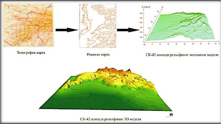
With the help of this program it is possible to create a 3D model of the terrain based on the topographic map of the region (Figure 2). To do this, the following sequence of practical work is performed using das tour [3 , 6 ] :
1. A trapezoid corresponding to its nomenclature is created for the topographic map.
2. The raster image of the topographic map is mounted on the created trapezoid.
3. The raster image is attached to a trapezoid.
4. The symbols (classifier) corresponding to the scale of the topographic map are selected and the required (dotted, linear, field) symbols are created.
-
5. Objects on the topographic map are digitized (visualization is carried
-
6. When all the objects are digitized, the matrix format of the area is created.
7. Based on the matrix format, a 3D model of the terrain is created.
out).

Figure 2. Steps to create a 3D model of the area in the panorama program
In conclusion, it can be said that the work on creating a 3D model of the terrain on the basis of the Panorama GIS program and topographic maps of different scales is carried out in the same sequence as above. In this case, special attention should be paid only to the selection of conditional symbols (classifiers) and the creation of trapezoids [ 4 ] .
From the created 3D model of the topography in geographical and geological surveys; landscape analysis; environmental monitoring; construction of settlements; study of agricultural lands; design of hydrography, irrigation and reclamation networks; study of linear structures (roads, railways, communication lines, etc.); can be used in the study of the effect of relief on the propagation of television and radio waves and in other research work.
Список литературы Creation of 3D model of place relief based on topographic maps and GIS
- Khromykh V.V., Khromykh O.V. Digital relief models: a tutorial. Tomsk: Publishing house "TML-Press", 2007
- T.A. Khlebnikov Creation of digital maps and plans by means of GIS "Panorama" [Text]: teaching method. allowance. - Novosibirsk: SGGA, 2007
- Abdumuminov B., Nazirova D., Mirtolipov R. Analysis of segmentation in the design of a digital elevation model // Problems of Science and Education No. 15 (99).- Moscow, 2020
- Abdumo'minov B.O. Creating a 3D model of the area based on topographic maps and GIS. Materials of the XVII Republican scientific-practical online conference of young scientists on current issues of implementation of science and innovative achievements in the formation of the digital economy Part I: - Samarkand, June 3, 2020, pp. 423-425.
- Abdumo'minov B.O. Creation of a digital model of the relief of Surkhandarya region / Monograph /. - Tashkent: "Innovation-Ziyo", 2020, 108 p.
- Mirmaxmudov E.R., Abdumuminov B.O.Sozdanie prostranstvennoy tsifrovoy modeli relyfa v GIS PANORAMA: uchebno-metodicheskoe posobie. - Tashkent, 2021.


