
Defensive Structures of the Khorasan–Kerman Route in Islamic Iran: A Structural-Conceptual Analysis of Ribats, Watchtowers, and City Gates
Журнал: Краткие сообщения Института археологии @ksia-iaran
Рубрика: Средневековье и новое время
Статья в выпуске: 284, 2026 года.
Бесплатный доступ
Along the path between Khorasan and Kerman in medieval Iran, defensive buildings weren’t just for fighting enemies they also regulated land access and movement along state corridors while showing religious beliefs. This paper looks at ribats, watchtowers, and city gates using a mix of architectural layout and conceptual meaning, combining history, space design, ideology, and construction traits. The goal is to show how these elements worked together as one system, boosting safety, state authority, and faith identity across eastern Iran. With a descriptive yet analytical approach, the study uses old manuscripts, maps, building records, and on-site observations to support its points. Results suggest that these constructions placed carefully (like ribats spaced about 25–30 km apart), built with regional materials, designed with intent helped unify territory while strengthening political and spiritual legitimacy during Seljuk and Safavid rule. Instead of looking at these structures through just one lens or scattered locations, this study dives into the less-explored Khorasan–Kerman path using multiple angles. Findings here might feed into how we preserve heritage and understand old buildings.
Короткий адрес: https://sciup.org/143186459
IDS: 143186459 | DOI: 10.25681/IARAS.0130-2620.284.221-237
Оборонительные укрепления на пути из Хорасана в Керман в исламском Иране: структурно-концептуальный анализ рибатов, сторожевых башен и городских ворот
В средневековом Иране оборонительные сооружения на пути из Хорасана в Керман строились не только для борьбы с врагами. Их использовали для регулирования доступа к земле и контроля перемещений по государственным дорогам; рибаты также становились религиозными центрами. В статье рассматривается архитектурный план, концептуальное значение, история, организация внутреннего пространства и особенности строительства рибатов, сторожевых башен и городских ворот. Цель работы состоит в демонстрации функционирования перечисленных элементов как единого целого, как системы, которая обеспечивала охрану путников и поддерживала государственную власть и религиозную идентичность в восточной части Ирана. Используя описательный подход и аналитический инструментарий, авторы изучили древние рукописи, карты, строительную документацию и посетили сами объекты для проверки своих предположений. Согласно результатам исследования, возведение сети рибатов тщательно планировалось (расстояние между ними составляло от 25 до 30 км); при строительстве использовался местный материал; на рибаты возлагалась задача объединения групп населения и укрепления политической и духовной легитимности в эпоху Сельджуков и Сефевидов. Вместо рассмотрения данных сооружений с какой-то одной точки зрения или представления рибатов как сети разбросанных повсеместно укреплений в данном исследовании предпринимается попытка провести более детальный и многофакторный анализ недостаточно хорошо изученного пути из Хорасана в Керман. Полученные выводы могут оказаться полезными для разработки методов сохранения культурного наследия и изучения древних сооружений.
Текст научной статьи Defensive Structures of the Khorasan–Kerman Route in Islamic Iran: A Structural-Conceptual Analysis of Ribats, Watchtowers, and City Gates
In Islamic societies, trade routes were not just lanes for moving goods or spreading beliefs – instead, they helped shape power structures and protect borders while showing cultural stance (Matthee, 2022. P. 507). Forts like ribats, lookout posts, and urban entrances went beyond warfare duties; rather, they created physical layouts that controlled land and expressed ruling ideologies (Farrokh et al., 2021; Javadpour et al., 2024). Of these, the Khorasan–Kerman trail operated as a central east–south
corridor linking Khorasan to Kerman under Seljuk and Safavid rule, binding outer zones to the heart of authority.
Along a linked system of defensive buildings, this route helped secure land, shield trade groups, while boosting government authority ( Karimian , 2010). Features like placement on key spots, use of nearby resources, or inclusion of spiritual signs in these constructions revealed how power was exercised and nature was managed. Take Ribat Sharaf from the Seljuk time – its decorative program and Quranic inscriptions appear to reflect Sunni patronage traditions common in the Seljuk realm, whereas Ribat Zeinoddin from the Safavid era stands for Shiite culture ( Hasibi et al. , 2024).
This piece introduces a hands-on framework to explore how ribats, watchtowers, and city gates functioned along the Khorasan–Kerman road. Instead of just listing features, it digs into their layered roles using old texts, maps, building records, and on-the-ground notes. Through a close look at these sources, the work builds a picture of space tied to belief systems in Islamic Iranian design. Rather than treating them as isolated spots, it shows how these sites worked together – boosting safety, shaping rule, while helping form religious identity. Alongside, it opens fresh angles for saving heritage and rethinking architectural history.
Research Questions
-
1. How did the defensive buildings along the Khorasan–Kerman route function as an integrated spatial and ideological network during the Seljuk and Safavid periods?
-
2. In what ways did architectural form, layout, and decoration reflect or negotiate political and religious authority across different times and regions?
-
3. How can spatial distribution, material evidence, and textual data together clarify the transformation of eastern Iran’s defensive systems?
Literature Review
Studies into protective buildings in Islamic Iran usually look at single spots like roadside inns, watchtowers, or city gates without seeing how they connect as both physical and symbolic networks. Babaie and Grigor looked at how Safavid design showed power and faith in built form ( Babaie, Grigor , 2015). Farrokh alongside others analyzed military transitions from the late Sasanian to early Islamic Iran, focusing on tactical adaptation rather than architecture ( Farrokh et al. , 2021). Yet, none addressed how these constructions operated collectively as part of an integrated system. Hasibi alongside others checked how trade path changes reshaped caravanserais under Safavid rule ( Hasibi et al. , 2024). Emami pointed out deeper meanings in Sa-favid buildings, especially along pilgrimage roads linking Isfahan to Najaf–Karbala ( Emami , 2024).
Regional examples pop up here and there Karimian’s 2010 look into urban layout in Bam ( Karimian , 2010); Javadpour and team’s 2024 breakdown of how city gates shape architecture ( Javadpour et al. , 2024); then Tahmasebizadeh with Mohammadi in 2022 exploring old gates in Kerman ( Tahmasebizadeh, Mohammadi , 2022). These offer solid detail, yet miss side-by-side analysis or any linked perspective.
Some old texts – like those by Istakhri and Al-Maqdisi – mention desert paths along with rest stops, though they don’t really explain how these spots connected or what beliefs shaped them ( al-Maqdisi , 2006; Istakhri , 2018). Petersen’s work from 2002 plus Kennedy’s earlier take in 2006 looked at watch systems across Levant and Anatolia; however ( Kennedy , 2006; Petersen , 2002), neither zeroed in on eastern Iran specifically.
So far, research hasn’t looked at how several fortifications operated together to support spiritual, governing, or supply goals. This work covers that missing piece by exploring ribats, lookout points, and entryways as linked parts shaping power dynamics and belief displays along the Khorasan–Kerman path.
Sample Selection Criteria
Sites were selected according to four criteria:
-
1. Chronology: Attribution to the Seljuk or Safavid period based on published sources.
-
2. Geographical relevance: Location along or near the historic Khorasan–Kerman corridor.
-
3. Functional indicators: Architectural or textual evidence of defensive, administrative, or symbolic roles.
-
4. Data availability: Presence of reliable published documentation, plans, or visual material.
Using these criteria, six representative sites were examined – three ribats (Sharaf, Mehr, Zeinoddin), the Tabas watchtowers, and the historic city gates of Yazd and Kerman.
Fourfold Analysis of Ribat Sharaf on the Khorasan–Kerman Route
Architectural-Functional Analysis. Covering around 5,000 sq. m, Ribat Sharaf follows a rectangular shape stretched from north to south. Instead of a single open space, it holds two central courtyards placed one after another. Four iwans line up across from each other, while approximately 40 rooms, each averaging about 4 × 4 m, are arranged on a single level with partially raised observation platforms for surveillance. Thick walls made of mudbrick and baked brick, about 1,5 m wide, form the stronghold’s shell. At each corner stands a watchtower rising 8 m high, with narrow openings allowing guards to keep watch. Entry happens through one main gate designed for control and monitoring. Locally made fired bricks combined with gyp-sum-sarooj mortar helped the building resist harsh desert wear over time. Inside, users had access to a large water tank holding up to 50 cub. m. Alongside it, stables could house between 20 and 30 animals, storage areas held supplies, and a modest mosque included a mihrab pointing south – to serve both daily needs and prayer duties ( Hasibi et al. , 2024; Javadpour et al. , 2024).
The layout shows clear thinking behind shelter for travelers, handling supplies, while also offering protection. Its boxy shape, side towers, besides a central hub for services, brings to mind Anatolian ribats like Sultan Khan ( Hillenbrand , 1994), where design, purpose, alongside spiritual meaning are tightly linked.
Spatial-Strategic Analysis. Ribat Sharaf is located 136 km east of Mashhad towards Sarakhs and 6 km east of the village of Shorlaq ( Sheikhi, Adineh , 2020. P. 89) in geographical coordinates 36°15’59.81”N 60°39’19.06”E (fig. 1). Ribat Sharaf sits along the old trade route linking Nishapur, Sarakhs, and Merv, close where smaller desert paths cross. Situated roughly 10 m above the surrounding plain, the site provided commanding visibility in all directions particularly from the northern iwan, which served as the main lookout point. Based on modern topographic mapping, Ribat Sharaf lies roughly 26–28 km from nearby caravan stations such as Ribat Mahi and Gazik distances consistent with the Seljuk practice of spacing waystations about half a day’s journey apart. Its proximity about half a kilometer to a reliable water source further enhanced its strategic and logistical value for long-distance caravans.
Combined evidence from the 2021–2023 surveys and comparative map analyses including Istakhri’s itineraries and Stronach & Mousavi’s documentation indicates that the site was deliberately selected for both accessibility and surveillance ( Stronach, Mousavi , 2012). Comparable spatial logic is found in the Baghdad–Damascus ribat network examined by Petersen, where high-ground locations at crossroads were intentionally chosen to facilitate both surveillance and administrative control ( Petersen , 2002).
Historical-Political Analysis. Constructed between 1114 and 1116, during the later Seljuk period under the successors of Malikshah, Ribat Sharaf was likely built in response to regional instabilities particularly Transoxanian incursions and Ismaili activities along the eastern frontiers of Khorasan. Beyond its defensive role, the ribat oversaw major trade and pilgrimage routes linking Khorasan to Baghdad and the Hejaz; archaeological and textual evidence suggest that a modest but strategically organized armed garrison was stationed there. Although the site did not house a large military contingent, its imposing scale and prominent watchtowers visibly projected Seljuk authority and served as a psychological deterrent to rival powers ( Farrokh et al. , 2021; Karimian , 2010; Matthee , 2022). Comparable strategies appear at Qasr al-Hayr East in the Levant, where architecture combined symbolic representation and territorial control ( Kennedy , 2006). In a similar vein, Ribat Sharaf strengthened local defensive networks and embodied the Seljuk policy of consolidating frontier security while asserting imperial authority.
Conceptual-Ideological Analysis. The architectural vocabulary and inscriptions of Ribat Sharaf reveal how the Seljuk state merged aesthetics, faith, and authority into a coherent ideological statement. Inside the southern iwan, fragments of Qur’anic inscriptions including part of Surah Al-Imran (3:18) are rendered in monumental Kufic script emphasizing the oneness of God ( tawḥīd ). These texts, framed within geometric bands and star-shaped brickwork, are not purely ornamental; they manifest the doctrinal message of divine unity and legitimate rule under Sunni orthodoxy ( Emami , 2024. P. 42–46).
The repeated use of eight-pointed stars, interlocking polygons, and lotus-like motifs carved into baked brick symbolized both cosmic order and dynastic endurance. Such visual syntax reinforced the Seljuk notion of divine sanction linking spatial symmetry with theological balance ( Babaie, Grigor , 2015. P. 81–95). The mihrab, oriented precisely toward Mecca and formed in carved gypsum, further asserted
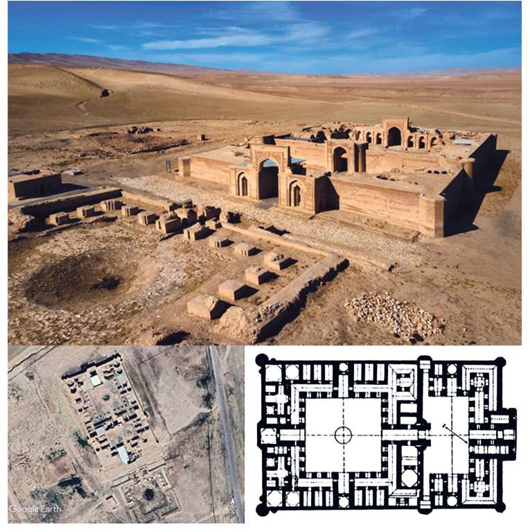
Fig 1. Ribat Sharaf Caravanserai, located near Sarakhs in northeastern Iran, built during the Seljuk religious orthodoxy within the imperial domain, paralleling similar devotional emphases in Khorasan’s contemporaneous ribats.
The northern iwan, with its sharply pointed arch rising nearly 10 m, created a sense of awe and vertical transcendence. As Emami notes, such monumental scale conveyed not only physical power but also spiritual gravitas. The interplay between elevation, inscription, and ornament thus acted as a visual discourse of legitimacy communicating both to travelers and to local populations that Seljuk authority rested on divine and political order ( Emami , 2024. P. 47–49).
Comparatively, this ideological expression mirrors patterns observed in Anatolian ribats, such as Sultan Khan and Karatay Han, where façades combined protective geometry with epigraphic assertion (Hillenbrand, 1994. P. 217–220). As Kennedy argues for early Islamic desert complexes, these forms served to make control visible. Hence, Ribat Sharaf can be read as both sanctuary and statement a space where art, religion, and power converged to perform Seljuk sovereignty in stone and brick (Kennedy, 2006. P. 163–165).
Fourfold Analysis of Ribat Mehr on the Khorasan–Kerman Route
Architectural-Functional Analysis. Ribat Mehr exhibits a nearly square layout organized around a central courtyard, employing the classic Seljuk four-iwan configuration with iwans positioned opposite one another and rounded corner towers reinforcing the outer edges. Constructed of fired brick bonded with lime–mud mortar and finished in gypsum plaster, the building rests upon a stone plinth stabilizing it against shifting desert sands. Approximately thirty chambers (each averaging 3,5 × 3,5 m) line the rear and side wings, supplemented by storage areas and an elevated shah-ne-shin on the eastern side features that imply both functional layering and hierarchical space use.
A centrally placed cistern estimated to hold around 30 cub. m occupies the main courtyard, while a hand-dug well in the northern sector appears to have ensured a year-round water supply, according to field documentation ( Hasibi et al. , 2024; Ja-vadpour et al. , 2024). Unlike open caravanserais, this ribat presents an enclosed and defensive form, providing controlled shelter and watch capability. In its massing and functional organization, it more closely resembles Seljuk-Safavid caravanserais such as Ribat Zeinoddin than Anatolian khans, balancing strategic defense with service infrastructure for caravans crossing the Lut Desert.
Spatial-Strategic Analysis. Ribat Mehr is located 5 km from the Sabzevar– Tehran road, next to Mehr village ( Tabesh, Arashmehr , 2015. P. 113), in the geographical coordinates 36°17’4.29”N 57° 8’36.61”E (fig. 2). Positioned at the northern threshold of the Lut Desert, Ribat Mehr lies between Ribat Zeinoddin (≈ 27 km southeast) and Yazd (≈ 29 km northwest) along the historical Mahriz–Anarak trail. The site occupies a nodal point where three caravan arteries intersect: one linking Kharanaq to Yazd, another connecting Mahriz to Tabas, and a southern route extending from Mahriz to Sirjan. Located only about 300 m from a perennial well and partially protected by an 8 m-high natural hill, the ribat commands broad visibility across the plain, with smaller outposts documented nearby.
Field data collected between 2021–2023, together with historical cartography (Historical maps and records…, 2019; Istakhri , 2018; Stronach, Mousavi , 2012), demonstrate that the site’s placement was deliberate balancing accessibility, communication, and surveillance. Within the wider Khorasan–Kerman corridor, Ribat Mehr served as an intermediate desert hub, regulating caravan flow, providing supplies, and facilitating state oversight between Yazd, Kerman, and southeastern frontier zones.
Historical-Political Analysis. Founded most likely in the late 12th century under the late Seljuks and repaired or expanded during the Safavid period, Ribat Mehr represents a hybrid stage in Iran’s defensive-commercial architecture. Though lacking an inscription naming a royal patron, its sharply profiled brick patterns, pointed arches, and diamond-shaped reliefs correspond to elite Seljuk–Safavid design idioms known from Nishapur and Isfahan ( Karimian , 2010; Matthee , 2022).
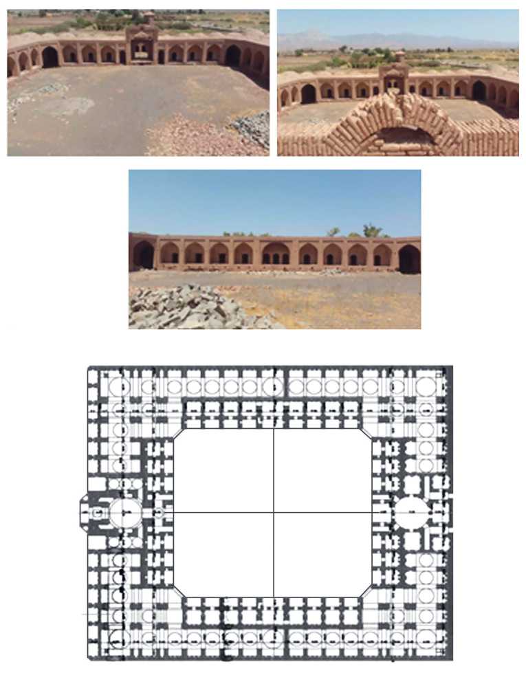
Fig 2. Ribat Mehr Caravanserai on the Khorasan–Kerman route, showing Seljuk-Safavid architectural features
Functionally, the ribat acted as both a logistical node and an administrative checkpoint securing trade convoys and courier networks traversing the Lut route. During the Safavid era, state-sponsored refurbishments likely coincided with broader policies to stabilize pilgrimage and trade infrastructure across southeastern Iran. Comparable to Qasr al-Hayr East in the Syrian Desert ( Kennedy , 2006. P. 163–165), Ribat Mehr conveyed authority through spatial presence rather than military aggression, asserting the permanence of state order within an otherwise uninhabited landscape.
Conceptual-Ideological Analysis. The decorative and spatial program of Ribat Mehr reflects an aesthetic of order and containment rather than overt religiosity. Rhythmic brick diamonds, sharply pointed arches, and continuous geometric repetition establish a sense of harmony and cosmic balance a concept echoed in broader Safavid architectural thought ( Emami , 2024. P. 51–55). The main entrance opens northwest, yet an illuminated chamber on the east side, containing a shallow niche roughly aligned toward Mecca, hints at occasional devotional use without functioning as a formal mosque space.
Semiotic parallels with late-Safavid caravanserais along the Isfahan–Karbala axis suggest a symbolic reading of the site: as a place of sanctuary, stability, and divine guardianship amid the harsh desert void ( Babaie, Grigor , 2015. P. 88–94). Thus, Ribat Mehr can be interpreted as both a material refuge and a metaphoric expression of protected travel under Islamic sovereignty embodying the synthesis of security, faith, and imperial presence characteristic of the Khorasan–Kerman network.
Fourfold Analysis of Ribat Zeinoddin on the Yazd–Kerman Route
Architectural-Functional Analysis . Ribat Zeinoddin presents a rare circular plan, roughly 50 m in diameter, surrounded by five semi-cylindrical towers and a main entrance oriented toward the northeast. Constructed from a combination of sun-dried and fired brick joined with lime – mud mortar, the outer walls – averaging 1,5 m in thickness – create a solid defensive perimeter. Inside, the architectural expression shifts toward simplicity: sharply pointed arches, rhythmic brick bonding, and restrained surface ornament typical of late-Safavid utilitarian design ( Hasibi et al. , 2024; Javadpour et al. , 2024).
The complex includes approximately 25 chambers (3 × 3 m each) for travelers, stables for 10–15 animals, storage rooms, and a central cistern of around 40 cub. m capacity. Ventilation was enhanced through wind-catchers (badgirs) and roof apertures that balanced temperature within the thick-walled enclosure. This circular geometry reduced blind corners and enabled continuous surveillance, while simultaneously embodying a symbolic sense of unity and divine order – concepts aligned with Safavid Shi‘i cosmology ( Babaie, Grigor , 2015. P. 92–94).
Typologically, the ribat corresponds to Safavid caravanserais such as Deir-e Gachin and Shah Abbas Inns along the Isfahan–Kerman route, combining practical fortification with a spiritual connotation of completeness and protection ( Emami , 2024. P. 60–63).
Spatial-Strategic Analysis. Located on the Yazd–Kerman road, Ribat Zeinoddin occupies a transitional zone between the Lut Desert and the Mahriz mountain foothills. The site lies roughly 60 km southeast of Yazd, 30 km from Kharanaq, and
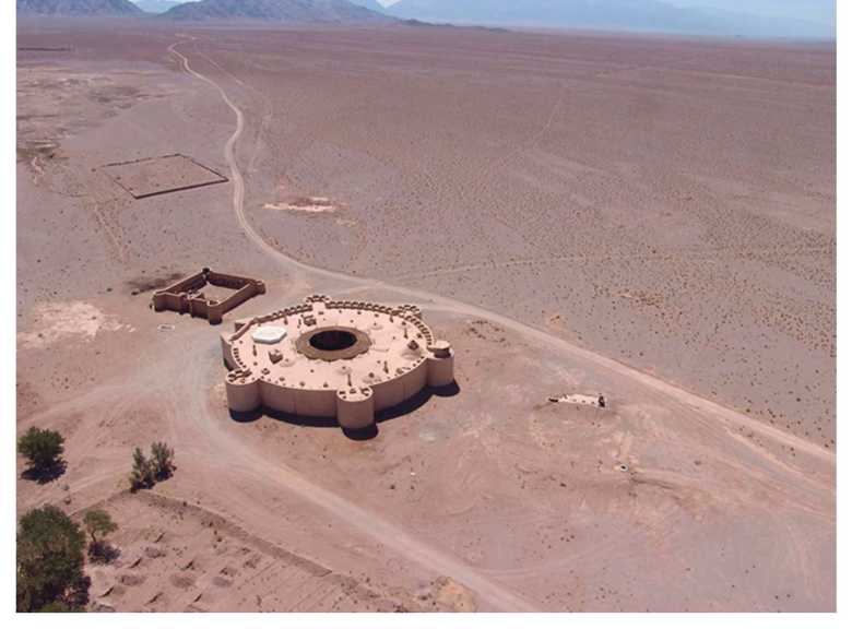
Fig 3. Ribat Zeinoddin Caravanserai near Yazd, a circular Safavid-era structure along the desert road ( Seyyed Hamzeh, Soltanahmadi , 2020. P. 7)
25 km northwest of Ribat Mehr, marking it as a strategic midpoint on the Khorasan– Kerman trade and pilgrimage axis in the geographical coordinates 31°24’42.37”N 54°42’24.80”E (fig. 3). Only about 200 m from an active qanat and adjacent to Fahraj village, the ribat benefitted from steady water access and a defensive elevation about 6 m above the plain, providing extensive visibility over caravan tracks.
Field documentation from 2021–2023, corroborated with early cartographic sources (Historical maps and records…, 2019; Istakhri , 2018; Stronach, Mousavi , 2012), confirms that the circular layout enhanced 360-degree observation and minimized construction stress on wind-exposed plains. In functional hierarchy, Zeinoddin acted as a central node in the Safavid way-station network, paralleling sites like those along the Isfahan–Shiraz route ( Petersen , 2002. P. 221–225), ensuring both the security of caravans and control of desert passageways.
Historical-Political Analysis. Constructed circa 1611 under the rule of Shah Abbas I, Ribat Zeinoddin stands as a distinct example of Safavid centralized planning in Iran’s desert frontier. Its design emphasizes geometric perfection, order, and symmetry hallmarks of Shah Abbas’s architectural ideology linking aesthetic discipline with administrative control (Matthee, 2022).While devoid of epigraphic royal inscriptions, its stylistic restraint pointed brick arches, balanced proportions, and defensive regularity projects imperial authority through function rather than ornament. As with caravanserais at Gaz and Meimand, Zeinoddin formed part of a state-run logistic chain protecting commerce, pilgrimage, and communication routes (Karimian, 2010. P. 44–58). In this sense, it embodied the Safavid policy of «imperial order through infrastructure», extending Tehran-Isfahan governance deep into Iran’s arid interior.
Conceptual-Ideological Analysis. Symbolically, Ribat Zeinoddin’s circular geometry expresses both inclusiveness and divine unity, echoing cosmological models prevalent in Safavid Shi‘ism. The alignment of internal chambers toward qibla and the organization around a central void parallel metaphors of spiritual centrality and balance. The northeast-facing entrance follows the trade axis rather than liturgical orientation, indicating pragmatic design merged with sacred allusion.
Brick reliefs near the inner iwan, forming five-pointed patterns, have been interpreted as visual references to the Panj-tan the Five Holy Figures in Shi‘i devotion ( Babaie, Grigor , 2015. P. 93, 94). These motifs, observed also in late-Safavid inns along the Najaf–Karbala corridor ( Emami , 2024. P. 61, 62), underscore how state architecture intertwined with religious symbolism to legitimize rule. Through its form and iconography, Ribat Zeinoddin thus functioned not merely as a desert refuge but as a spatial statement of sacred kingship within Iran’s Safavid domain.
Watchtowers of the Khorasan–Kerman Route Fourfold Analysis of Tabas Watchtowers
Architectural-Functional Analysis. The Tabas watchtowers, located along the junction of the Khorasan–Yazd and Khorasan–Kerman branches, are among the best-preserved in Iran’s eastern desert. Most are cylindrical or multi-faceted, 4–6 m in diameter, and 6–10 m high. Built from sun-dried and baked bricks set in mud-lime mortar, then coated with kargel, they resist erosion effectively. Inside, helical stairs lead to roof platforms; arrow-slit openings at staggered heights provide nearly 360° visibility. A few larger towers roughly 10 sq. m in floor area include niches for temporary shelter or weapon storage ( Hasibi et al. , 2024; Javadpour et al. , 2024).
Their spatial configuration parallels Levantine frontier posts like Qasr al-Hayr East ( Kennedy , 2006), showing transregional military adaptation to desert terrain. Structurally, these towers acted as modular surveillance units, complementing nearby caravanserais such as Ribat Mehr and Ribat Zeinoddin.
Spatial-Strategic Analysis. Positioned near the convergence of the Tabas–Fer-dows and Khorasan–Kerman routes, these towers commanded approaches leading to central Iran and Sistan. Their placement often 3–5 km apart and 200–300 m from palm groves or water points ensured continuous lines of sight across the northern Lut Desert. Archival maps and written itineraries (Historical maps and records…, 2019; Istakhri , 2018; Stronach, Mousavi , 2012) confirm their networked spatial logic, comparable to Petersen’s findings on the Baghdad–Damascus defense chain ( Petersen , 2002). Tabas thereby emerged as a strategic monitoring hub linking northeastern Iran to desert transit systems farther south.
Historical-Political Analysis. Textual sources and stylistic dating suggest the Tabas towers were constructed or refurbished under the Safavids, particularly during Shah Abbas I’s reign (c. 1611), as part of a larger plan to stabilize pilgrim- age and trade corridors. Given Tabas’s midway location between Yazd, Ferdows, and Kerman, these towers supervised nomadic activity, secured agricultural oases, and displayed central authority in peripheral landscapes (Matthee, 2022). Later Qajar-pe-riod accounts confirm their continued defensive use for protecting water systems and local borders (Javadpour et al., 2024). Comparable defensive logic appears in Ottoman frontier towers of Anatolia (Hillenbrand, 1994), underlining a shared imperial approach to desert governance.
Conceptual-Ideological Analysis . Although modest in scale, Tabas towers carried ideological resonance. Their vertical proportions rising roughly three times their width and solitary silhouettes projected an image of watchfulness and divine oversight. In Safavid thought, such elevated, enduring forms symbolized the state’s spiritual guardianship over the frontier ( Babaie, Grigor , 2015). While lacking explicit inscriptions, their repetition along sacred and commercial routes echoed the symbolic geography of Shi‘i pilgrimage, comparable to way-marking structures between Najaf and Karbala ( Emami , 2024).
Studies on architectural semiotics ( Farrokh et al. , 2021) interpret these towers as physical metaphors of sovereignty and faith – asserting power through visibility, permanence, and sacred order in the landscape.