Determining and monitoring the area with the potential for desertification in Khorezm oasis using spatial data

Author: Boymurodov R.Z., Amanov A.K., Adambaev A.R.
Journal: Экономика и социум @ekonomika-socium
Section: Основной раздел
Article in issue: 7 (98), 2022.
Free access
In this research work, desertification factors and geomorphological surfaces have been studied. The hazard classification map provides conditions for recognizing important centers of hazards and preventing hazards in the basin. As a result, natural vegetation decreases and soil erosion occurs. Desertification factors such as climate, relief, land use, geographical location are effective in the development of desertification. Advances in technology affect desertification quantification using remote sensing and GIS software as important tools for desertification risk classification mapping, especially for large areas.
Gis software, lower amudarya, landsat, qgis, etm+, ndvi, lst
Short address: https://sciup.org/140299142
IDR: 140299142
Text of the scientific article Determining and monitoring the area with the potential for desertification in Khorezm oasis using spatial data
Desertification – Today, the livelihoods of more than 1.2 billion people living in droughts in 110 countries are threatened by drought and desertification (Gurung). 2010). The characteristics of climate factors, population growth and land use are important factors for the development of desertification.
In the following decades, the process of land degradation and desertification accelerated in Uzbekistan under the influence of the following factors: firstly, the population increased by 1.5 times in the last 25 years; secondly, the increase in agricultural and livestock products forced people to use land extensively or to convert forests and pastures into cultivated areas; and third, excessive use of wood and plants as domestic heating fuel exacerbates desertification.
This work presents a classified desertification hazard map of the Lower Amudarya. Climate factors, geographic location, and human activities have many potential effects on the development of desertification. This study is based on forecasting and modeling of desertification in the study area. The classification method is based on basic parameters such as soil and climate characteristics. DEM, LANDSAT imagery (ETM+), statistical data and vector map are used as datasets for desertification map classification. The sum of the score parameters was estimated using the mean value. In this study, QGIS 3.16 was used for the analysis of vector and raster layer maps, as well as for the recognition study of the study area using satellite images. The most important factors of the risk of desertification in the Lower Amudarya are geographical location, salinity zone, altitude, slope and human activity. An important factor of desertification in the area can be the geographical location of the basin, which is close to the desert area. The use of raster data and QGIS software is useful for classification of desertification risk maps, especially the most important factors of desertification risk - geographical location of the area, salinity zone, altitude, slope and human activity.
Figur 1 . Khorezm oasis
We used the Normalized Difference Vegetation Index (NDVI), a normalized quantitative index of active biomass, to evaluate vegetation from satellite imagery. It is known that the purpose of NDVI is to determine the areas covered and not covered by vegetation, to evaluate and monitor the condition of vegetation, and to establish the productivity of vegetation.
The following level of green NDVI phytomass development level was adopted in relation to the study area:
-
- very high- more than 0.20
-
- high – from 0.15 to 0.20 high
-
- average - 0.10-0.15
-
- low - 0.05-0.10
-
- Very low - 0 to 0.05
-
- Field ground-0 and smaller
When the NDVI value is <0.1, vegetation is usually absent (bare soil, water, artificial surfaces). A dimensionless discrete scale was used to represent NDVI.
Research methodology.
Object detection and detection is useful for combining different bands on Earth to create images in natural colors or pseudo-color images. Semi-automatic extraction of interesting objects (vegetation, water bodies, etc.) involves the construction of different band ratios. By calculating the normalized indicator of vegetation indicators NDVI, it is common to distribute areas with vegetation cover:
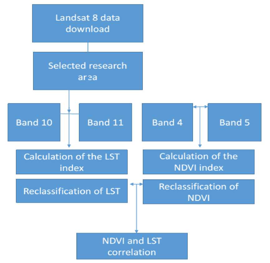
Figur 2 . Research methodology
The range of NDVI values varies from -1 to 1, with the highest values indicating lush vegetation and the lowest values indicating sparse vegetation cover.
NDVI values need to be classified in order to accurately determine the areas covered by vegetation. For validated NDVI visualizations, equal values must be set separately for each satellite to calculate the difference between each satellite image. NIR is band 5 and RED is band 4 for Landsat 8 imagery.
Results and discussion : The first step is to download a Landsat 8 image from a specific location, open it and check the necessary information (in metadata) to perform this procedure.
This guide shows how to calculate land surface temperature (LST) using Landsat 8 bands. Specifically, band 10 as a thermal band and bands 4 and 5 to calculate the Normal Difference Vegetation Index (NVDI).
Use USGS formulas to calculate LST more info Automatic land surface temperature mapping algorithm using LANDSAT 8 satellite data.
TOA (L) = M * Q + A
BT = (K / (ln (K / L) + 1)) - 273.15
Correlation between NDVI and LST
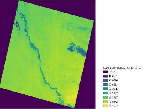
Figur 3. LST index
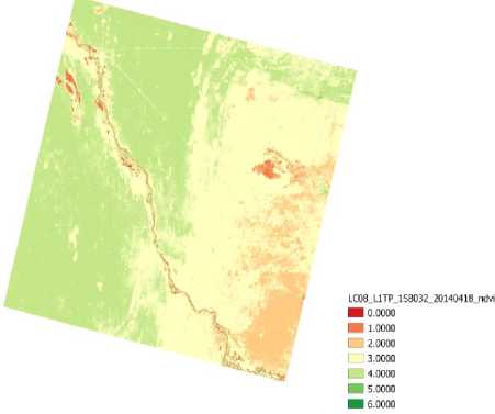
Figur 4. NDVI index
Land surface temperature (LST) is widely required in hydrology, meteorology, and climatology as a key indicator of Earth's surface temperature. It is important for the net radiation balance on the Earth's surface and is an important indicator of the greenhouse effect and the energy flow between the atmosphere and the land.
Conclusions: Estimation of land surface temperature (LST) using Landsat 8 data is an important factor in many fields such as climate change, urban land use/land cover, heat balance studies and is an important factor for climate models. LANDSAT data have provided many opportunities to study land processes using remote sensing. LST was estimated from the Normalized Difference Vegetation Index (NDVI) values determined from the Red and Near Infrared bands.
Studies using NDVI and LST, taking into account the differences in spectral reflectance for different channels of the optical range, together with measurements, allow rapid identification of ecological risk caused by vegetation and desertification disturbances.
References Determining and monitoring the area with the potential for desertification in Khorezm oasis using spatial data
- Criterion def inition for the identif ication of physical-geographical boundaries of Khorezm oasis through remotely sensed data. Muzaffar Matchanov & Ana Teodoro & Christoph Schroder. Received: 6 May 2015 / Accepted: 7 December 2015 / Published online: 16 December 2015 # Springer International Publishing Switzerland 2015.
