Development of economic-mathematical models for optimizing the agricultural land use through GIS technologies (on the example of Chimbay district of the Republic of Karakalpakstan)
")
Author: Bekanov K.K.
Journal: Экономика и социум @ekonomika-socium
Section: Основной раздел
Article in issue: 9 (88), 2021.
Free access
The article addresses the issue of developing a model for optimizing the use of agricultural land. The negative impact of environmental factors of the Aral Sea requires more labor in obtaining high yields from agricultural lands in the region. The research aims to increase land use efficiency based on the placement of agricultural crops through optimal solutions. The main goal of optimization is to minimize the resources expended in the cultivation of agricultural products. The agricultural land use optimization model was implemented using the GIS and linear programming simplex method, and the results are depicted on a 1:10 000 scale map. The farm lands of Chimbay district were selected as the object of the research and 3 different solutions for the placement of crop types were proposed. Scenarios for the placement of agricultural crop types were implemented through the ArcGIS 10.6 program and the ArcPy application. The amount of resources used to grow the crop types on the selected 100 hectares of irrigated land was calculated. Through this optimal solution, the resources spent on the cultivation of various crops have been reduced by 11%. The developed optimization model will significantly help to increase the efficiency of agricultural land use in the correct placement of agricultural crops, taking into account environmental and economic factors.
Agricultural land use, land use optimization, GIS technologies, irrigated land, crop types
Short address: https://sciup.org/140254887
IDR: 140254887 | UDC: 528.1:504.75:631.1(575.1)
Text of the scientific article Development of economic-mathematical models for optimizing the agricultural land use through GIS technologies (on the example of Chimbay district of the Republic of Karakalpakstan)
Introduction. It is known that the Republic of Karakalpakstan is located in the northwestern part of Uzbekistan. This requires specific approaches in the use of agricultural land. For example, in the southern regions of Uzbekistan, there is an opportunity to get harvest twice, while in the northwestern part such an opportunity is much more limited. The negative impact of environmental factors of the Aral Sea requires more labor in obtaining high yields for the Lower Amudarya region. The drying up of the Aral Sea has become one of the greatest environmental tragedies in human history (Turdimambetov et al., 2021 and Reimov 2014). The salts and sands of the seabed, which have become desert, are endangering human life and nature (Bekanov et al., 2020 and Safarov et al., 2020). The worst affected are the people living in the Aral Sea region and agricultural lands. As a result of the deterioration of the ecological situation, the efficiency of agricultural land use is declining from year to year (Galán-Martín, 2015). In such conditions, mitigation of the ecological condition of lands, the establishment of rational and efficient use of land resources and optimization of their use is one of the most urgent tasks at the moment. Optimization is the process of choosing the most optimal solution taking into account these available options (Olshevskiy, 2010).
Land use optimization means achieving environmental, economic and social efficiency based on the most optimal solutions, taking into account the available natural resources, land resources, water resources and labor resources (Valeriy, 2015).
Thus, by optimizing the use of land in complex ecological conditions, it is possible to improve the ecological condition of agricultural land, increase the profitability of agricultural production, improve the living standards of the population.
Land use optimization is an economically expensive process. With this in mind, the most effective solution in optimizing the use of agricultural land in the complex ecological conditions of the Republic of Karakalpakstan is the implementation of linear programming simplex method by integrating it into GIS. There are many types of optimization models used in solving various problems in the world today (Papalambros and Wilde, 2000; Troutman, 2006). The optimization model used in the implementation of design work was developed in the early 70's and is being used effectively (Agrawal and Heady, 1972; Hazell and Norton, 1986). In a broad sense, linear and closed-form models tend to find solutions in which certain functions have variables. Models known as linear programming were first developed in the 1930s for the optimal allocation of scarce resources (Djanibekov et al., 2013). In the 1980s, the development of algorithms to solve large problems of linear programming outside the simplification method was a major impetus in optimization (Karmarkov, 1984; Xillier and Liberman, 2001). Optimization models typically focus on the rational use of resources to achieve competitive products. They provide the ability to meet the requirements of constraints on a set of cost-related factors, as well as to address the issues of maximizing the required set of parameters. Quantitative optimization methods are routinely used in agriculture, industrial production, and the military to minimize costs or maximize performance in the performance of multi-purpose tasks. Such models have been effective in protecting and restoring the environment and in the efficient use of agricultural land (Aravossis et al., 2006).
Study Area. The study area of the research was selected farm irrigated lands located in Chimbay district of the Republic of Karakalpakstan. The total land area of the farm is 120 hectares, of which 100 hectares are irrigated arable land area. The farm specializes in agriculture and grows technical crops, cereals, legumes, oilseeds, vegetables, melons, potatoes, fodder crops. The average score of irrigated lands is 43 points. The climate of the region is very changeable, groundwater is close to the surface, summers are hot and dry, and winters are short but cold (Bekanov et al., 2020 and Safarov et al., 2020). The geographical location map of the object under study is shown in Fig. 1.
Fig. 1 . Location of the research object
Methodology. The methodology for optimizing the use of agricultural land is shown
below.
in
Figure
Linear Programming: Simplex Method
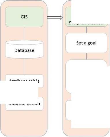
Determination of optimal solutions
Resource Optimization Scenarios
Fig. 2 . Methodology for optimizing the use of agricultural land
Attribute table
Data collection
At this stage, GIS technologies were used in the development of a model for optimizing the use of agricultural lands. The linear programming simplex method is not a program that performs complete spatial analysis work, but it can perform a number of spatial analysis tasks by integrating it into GIS software. Here, the geodatabase is the most basic tool. In this case, data on the object under study is collected, that is, a geodatabase is formed on the basis of field research and statistics. This geodatabase allows to obtain the necessary spatial data in the optimization of agricultural land use.
In the next stage, it is planned to place agricultural crops on the irrigated land of the research object, a total of 8 types of agricultural crops are technical crops, including cereals, legumes grains, oilseed crops, vegetables, melons, potatoes and fodder crops.
First of all, we need to determine the types of resources that will be spent on the cultivation of these crops. They are as follows:
-
- R - fuel lubricants materials;
-
- R - mineral fertilizers (nitrogen, phosphorus, potassium);
-
- R 3 - seed;
-
- R - salary contributions.
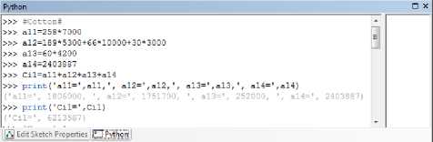
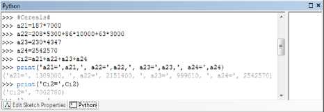
The total resource types were counted into 4 and they were denoted by a letter. Then, the amount of resources spent on the types of crops planted on 1 hectare of land was determined and is given in Table 1 below.
Table 1
Norms of resource consumption per 1 hectare in the cultivation of crops
|
Crop type |
Expended resources on cultivation the product |
|||||
|
Fuel lubricants materials (liters) |
Mineral fertilizer |
Seeds (kg) |
Salary contributions thousand Uzbek sums |
|||
|
Nitrogen (kg) |
Phosphorus (kg) |
Potassium (kg) |
||||
|
Technical crops |
258 |
189 |
66 |
30 |
60 |
2 403,8 |
|
Cereals |
187 |
208 |
86 |
63 |
230 |
2 542,5 |
|
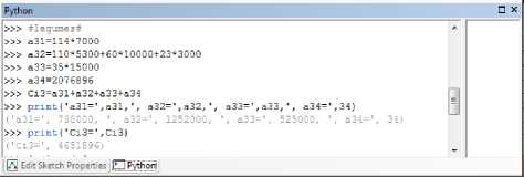
Legumes grains |
114 |
110 |
60 |
23 |
35 |
2 076,8 |
|
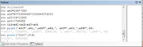
Oilseed crops |
156 |
97 |
62 |
45 |
19 |
1 746,2 |
|
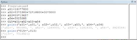
Vegetables |
140 |
83 |
72 |
30 |
59 |
3 925,1 |
|
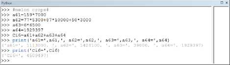
Melons |
159 |
77 |
87 |
50 |
5,7 |
1 929,3 |
|
Potatoes |
180 |
100 |
80 |
50 |
3000 |
4 030,0 |
|
Fodder crops |
201 |
104 |
73 |
34 |
27,5 |
1 181,4 |
The norms of resource consumption per 1 hectare in the cultivation of the types of crops listed in Table 1 are based on the norms of labor and material resources required for the cultivation of agricultural products, developed in 2016 by scientists of the Scientific Research Institute of Agricultural Economics of the Republic of Uzbekistan (Kholmurzaev et al., 2016).
Then we can determine the amount of expended resources on the cultivation of crops using the following equation.
4 C i = Z a j R j = 1
Equation 1 where i is crop type, R – R is resource type, j is resource consumption costs, a – i – crop j – resource consumption costs, Ci is total cost of spent on crops.
At the same time, it will be necessary to develop plans for the placement of crops on the total irrigated land of the farm. Scenarios for the placement of agricultural crops on 100 hectares of irrigated land in 3 different variants were developed (Table 2).
Table 2
Scenarios for the placement of agricultural crop types
|
Crop type indexation |
Crop types |
Proposed crop placement options (per hectare) |
||
|
А) |
B) |
С) |
||
|
i=1 |
Technical crops |
40 |
30 |
42 |
|
i=2 |
Cereals |
30 |
40 |
28 |
|
i=3 |
Legume grains |
2 |
5 |
3 |
|
i=4 |
Oilseed crops |
2 |
5 |
4 |
|
i=5 |
Vegetables |
6 |
10 |
7 |
|
i=6 |
Melons |
5 |
2 |
10 |
|
i=7 |
Potatoes |
5 |
2 |
5 |
|
i=8 |
Fodder crops |
10 |
6 |
5 |
According to the data in Table 2, the first plan, i.e. option A) technical crops are placed on 40 ha, cereals are placed on 30 ha, legume grains are placed on 2 ha, oilseed crops are placed on 2 ha, vegetables are placed on 6 ha, melons are placed on 5 ha, potatoes are placed on 5 ha, fodder crops are placed on 10 ha.
In the second plan, i.e. option B) technical crops are placed on 30 ha, cereals are placed on 40 ha, legume grains are placed on 5 ha, oilseed crops are placed on 5 ha, vegetables are placed on 10 ha, melons are placed on 2 ha, potatoes are placed on 2 ha, fodder crops are placed on 6 ha.
In the third plan, i.e. option C) technical crops are placed on 42 ha, cereals are placed on 28 ha, legume grains are placed on 3 ha, oilseed crops are placed on 4 ha, vegetables are placed on 7 ha, melons are placed on 10 ha, potatoes are placed on 5 ha, fodder crops are placed on 5 ha.
Based on the above information, the total amount of resources spent on each proposed plan is calculated. Restrictions are then placed on the placement of crop types. This can be done according to the following equation.
8 Z X ^ G a i = 1
Equation 2
Then the amount of resource imposed on common crop types is limited, which can be done through the following equation;
8 ____
Z a i x s R j (. j = W)
i = 1
Equation 3
Where:
-
- Rj - resource type,
-
- Ga - total crop area,
-
- x i -i - crop type area.
The next step is to minimize the amount of resources expended in the cultivation of crop types, which can be done by the following equation;
n
F (x) = ^ Cixi ^ min i=1
Equation 4
i=1)
i=2)
i=3)
i=4)
i=5)
i=6)
i=7) i=8)
Fig. 3 . Algorithms for calculating the amount of expended resources on technical crops performed in the ArcPy application
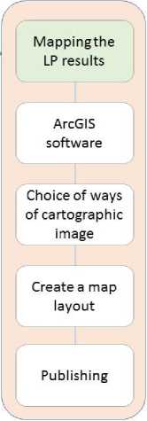
The mapping of the results describes the mapping of the results of the placement of the optimal crop types determined by the linear programming simplex method as the final stage of this model (Figure 3). In this case, first of all, the data is analyzed in ArcGIS and queries are made on the area of crop types, in which case it is advisable to use SQL. Then, after determining the location of crop types, imaging methods are selected and each type of crop is marked with symbols. Then the layout is performed, in which the map name, frame, scale, symbols and additional information are placed, the map is exported to raster mode, and the map can be printed.
These scenarios are illustrated in the maps in Figure 3 below.
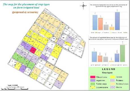
а)
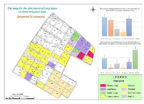
b)
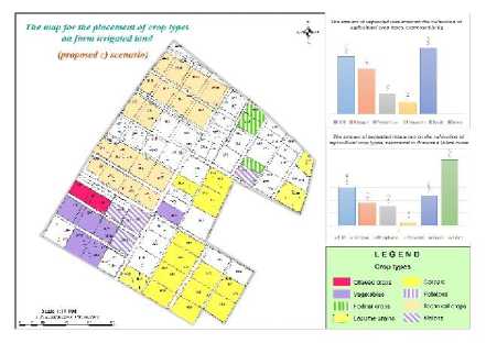
с)
Fig. 4 . Scenarios for the placement of crop types on farm irrigated land (proposed a) b) c) scenarios)
Results and Discussion. Today in the world there is a growing demand for food, efficient use of agricultural land, as well as the need for planning tools for their rational use. It is common practice to integrate geographic information systems (GIS) with addon software packages. For example, overcoming the shortcomings of supporting spatial decisions. This means that data exchange is done on the basis of appropriate software. A number of scientific research works have been analyzed in this direction. Scientists from Kiel University have developed a model for optimizing the multi-object distribution of GIS-based land resources. It is a standalone application that integrates with ArcGIS. The “Multiobjective Optimization” model is designed to optimize land use content. At the same time, the land use structure is optimized mainly by minimizing soil erosion. The disadvantage of this model is its limited capabilities, given the geometry and topological structure of the alternatives in the optimization procedure (Alexander, 2008; Jain and Ramsankaran, 2019). Oregon State University scientists have also provided opportunities to plan land use by integrating optimization methods with GIS. The benefits of using these technologies together in research are scientifically based. It also emphasizes the need to process the results obtained on the basis of optimization methods, i.e. linear programming models (Jeffrey and Darek, 1997).
Scientists at Rovira and the University of Virginia have developed a multi-step linear programming model that determines optimal decisions. Through this model, Spanish farms have achieved the placement of optimal agricultural crop types that maximize production profitability. Furthermore, it is noted that this model is effective in protecting the environment (Galán-Martín et al., 2015).
Alcala University scientist Emilio Chuvieco (1993) in his research conducted research on spatial modeling of linear programming within GIS. The main goal of the research was to optimize land use by minimizing agricultural unemployment.
According to the results of the analysis, optimization of agricultural land use by integrating optimization methods, i.e. linear program simplex method, into GIS was found to be effective.
In contrast to previous work on this topic, the work we presented was performed using the linear programming simplex method using a geodatabase model of agricultural land use optimization, and the results are depicted on a 1:10 000 scale map. The linear programming simplex method is not a program that performs complete spatial analysis work, but it can perform a number of spatial analysis tasks by integrating it into ArcGIS software.
Three different solutions for the placement of crop types in the study area were proposed. The main limitations of the solutions were to take into account environmental and economic factors, and the scenarios for the placement of agricultural crop types were implemented in the ArcGIS 10.6 program and the ArcPy application.
ArcPy is a set of Python programming languages designed to manage, analyze, and perform a number of other tasks in Python. ArcPy is an application that helps perform tasks in GIS via Python.
The amount of expended resources on the cultivation of crop types on the selected 100 hectares of c was calculated. In the first solution a) the total expended resources were 74424 kilograms or 687393 thousand Uzbek sums, in the second solution b) 66709 kilograms or 587835 thousand Uzbek sums, and in the third solution c) 75263 kilograms or 707677 thousand Uzbek sums. It can be seen that the most optimal of these solutions is solution b). Through this optimal solution, an 11% reduction in the expended resources on the cultivation of crop types was achieved.
The amount of expended resources expressed
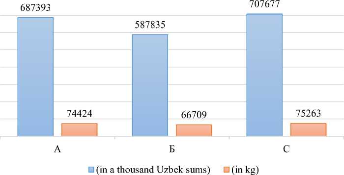
Fig. 5. The total amount of expended resources on the cultivation of agricultural crop types
The amount of expended resources expressed (in a thousand Uzbek sums)
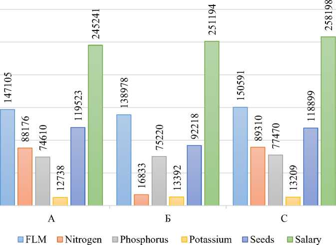
Fig. 6 . The amount of expended resources on the cultivation of agricultural crop types, expressed in thousand Uzbek sums
The amount of expended resources expressed
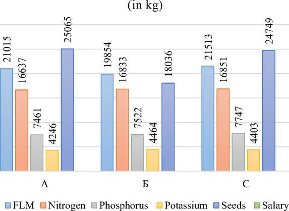
Fig. 7 . The amount of expended resources on the cultivation of agricultural crop types, expressed in kg
Conclusions. This created optimization model will significantly help to increase the efficiency of agricultural land use in the correct placement of agricultural networks, taking into account environmental and economic factors. The advantage of this is that the optimization model is integrated into the GIS program, i.e. it is possible to track the results of the solutions on maps and select the optimal solutions by setting a number of constraints. This research was conducted on farm lands in Chimbay district of the Republic of Karakalpakstan and was optimized by minimizing the amount of resources consumed by placing optimal crop types, taking into account the natural, economic and environmental factors of the area. Using this optimization model, it is possible to place optimal crop types on all farms in the regions of Uzbekistan, taking into account their natural, economic and environmental factors. Furthermore, may be able to distribute agricultural crops evenly and correctly between districts.
References Development of economic-mathematical models for optimizing the agricultural land use through GIS technologies (on the example of Chimbay district of the Republic of Karakalpakstan)
- Alexander Herzig, 2008, A GIS-based Module for the Multiobjective Optimization of Areal Resource Allocation, 11th AGILE International Conference on Geographic Information Science, 1-17.
- Aravossis, K., Brebbia, C.A., Kakaras, E. and Kungolos A.G., 2006, Environmental Economics and Investment Analysis, Southampton, England: WIT Press.
- AGRAWAL, R.C. and E.O. HEADY (1972): Operations Research Methods for Agricultural Decisions. Iowa State University Press, Iowa.
- Bekanov, K. et al., 2020, Creating land use/land cover map using methods GIS and remote sensing (on the example the Chimbay district of the Karakalpakstan republic), International Journal of Pharmaceutical Research. Vol. 12, Iss. 3.
- Chuvieco, E., 1993, Integration of linear programming and GIS for land-use modelling, International Journal of Geographical Information Systems, 7(1), 71–83, doi:10.1080/02693799308901940.
- Djanibekov, N., Sommer, R., & Djanibekov, U., 2013, Evaluation of effects of cotton policy changes on land and water use in Uzbekistan: Application of a bio-economic farm model at the level of a water users’ association, Agricultural Systems, 118, 1–13. doi:10.1016/j.agsy.
- Galán-Martín, Á. P. G., 2015, Multi-stage linear programming model for optimizing cropping plan decisions under the new Common Agricultural Policy, Land Use Policy. 48, 515–524.
- Galán-Martín, Á., Pozo, C., Guillén-Gosálbez, G., Antón Vallejo, A., & Jiménez Esteller, L., 2015, Multi-stage linear programming model for optimizing cropping plan decisions under the new Common Agricultural Policy, Land Use Policy, 48, 515–524. doi:10.1016/j.landusepol.
- Jain, P., and Ramsankaran, R., 2019, GIS-based Integrated Multi-Criteria Modelling Framework for Watershed Prioritisation in India—A Demonstration in Marol Watershed, Journal of Hydrology, 124131, doi:10.1016/j.jhydrol.2019.124131.
- Jeffrey, L. Arthur and Darek, J. Nalle, 1997, Clarification on the use of linear programming and GIS for land-use modelling, int. j. geographical information science, vol. 11, no. 4, 397±402.
- Kholmurzaev, I. et al., 2016, Qishloq xo'jalik mahsulotlarini yetishtirishda talab etiladigan mehnat va moddiy resurslar sarfi me'yorlari, Tashkent, 9-37.
- Olshevskiy, A.V. Yatsukhno, V.M. 2010, Optimizatsia agrarnogo zemlepolzovaniya na landshaftnoy osnove s ispolzovaniem GIS-tehnologiy (na primere Belorusskogo polesya), Nature management: ecology, economics, technology, Materials of the International Scientific Conference, Minsk, October 6-8, 231-238.
- Papalambros, P.Y. and Wilde, D.J., 2000, Principles of optimal design: modeling and computation, 2nd edition, (http://www.optimaldesign.org/), Cambridge: Cambridge University Press.
- Reimov, P., and Fayzieva, D., 2014, The Present State of the South Aral Sea Area, In Micklin, P., Aladin, N.V. and Plotnikov, I., (Eds.), The Aral Sea, 171–206.
- Safarov, E. et al., 2020, Application of geoinformation technologies and remote sensing to detect land use and changes in the soil cover caused by the drying of the Aral Sea. Periódico Tchê Química. ISSN 2179-0302. vol.17 (n°36).
- Turdimambetov I., Madreymov, A., Foldvary L., Oteuliev M., Kurbanov, V., Utarbaeva, K., Bekanov, K., 2021, Influence of Adverse Ecological Factors on the Incidence of Malignant Neoplasms, E3S Web of Conferences, Volume 227, https://doi.org/10.1051/e3sconf/202122702001.
- Valeriy Alakoz, 2015, Sistema optimizatsii selskohozyaystvennogo zemlepolzovaniya, Zemelnie otnosheniya i zemleustroystvo, 3-8p.
