Dynamics of engineering and geological conditions of mineral deposits (from exploration to exploitation)
")
Author: Abaturova I.V., Storozhenko L.A., Nugmanova E.D., Kozlov V.S.
Journal: Вестник Пермского университета. Геология @geology-vestnik-psu
Section: Инженерная геология, мерзлотоведение и грунтоведение
Article in issue: 3 т.20, 2021.
Free access
The development of mineral deposits has strong transformative effect on the geological environment. At the same time, all the components of geotechnical conditions (relief, structure of rock massifs, hydrogeological and geocryological conditions etc.), formed over a long geological time, are actively changing. Geological processes are activated and new mining-geological processes are formed. New strata are formed on the Earth's surface along with the technogenic formations and technogenic deposits. Today, the scale of technogenesis in mining is comparable to the results of geological activities that have been going on for many millions of years. The reaction of the geological environment is immediate and is expressed in the development of large-scale engineering and geological processes, which often do not allow the further development of mineral resources and threaten the human life. Therefore, even at the early stages of prospecting and/or exploration, it is necessary to understand the dynamics of changes in surrounding medium in order to develop methods for proper managing of the ore extraction. By the example of a number of objects, all the stages of study of engineering-geological conditions are considered, the dynamics of their change, which led to the formation of engineering-geological processes affecting the further development of mineral resource, is estimated.
Mineral deposits, geological environment, geotechnical processes, engineering-geological conditions, engineering-geological model, dynamics of engineering-geological processes, stability of quarry walls, physical and mechanical properties, fracturing
Short address: https://sciup.org/147246213
IDR: 147246213 | UDC: 624.131.3 | DOI: 10.17072/psu.geol.20.3.222
Динамика инженерно-геологических условий месторождений полезных ископаемых (от разведки до эксплуатации)
Разработка месторождений полезных ископаемых (МПИ) оказывает сильное преобразующее воздействие на геологическую среду. При этом активно изменяются все составляющие инженерно-геологических условий (ИГУ), сформировавшиеся в течение длительного геологического времени: рельеф, структура массивов горных пород, гидрогеологические и геокриологические условия, активизируются геологические процессы и формируются горно-геологические, при этом на поверхности Земли образуются новые толщи техногенных образований, а зачастую и техногенные месторождения. Масштабы техногенеза в горном деле на сегодняшний день соизмеримы с результатами геологической деятельности, протекавшей на протяжении многих миллионов лет. Реакция геологической среды не заставляет себя ждать и выражается в развитии масштабных инженерно-геологических процессов, которые зачастую не позволяют производить дальнейшую отработку МПИ и угрожают жизни людей. Поэтому еще на ранних этапах изучения ИГУ МПИ (поиски, разведка и разработка) необходимо понимание динамики изменения ИГУ с целью прогнозирования мероприятий по управлению устойчивостью бортов карьеров. В данной работе на примере ряда объектов обозначены все этапы изучения ИГУ, рассмотрена динамика их изменения, которые привели к формированию инженерно-геологических процессов, неблагоприятно влияющих на дальнейшую отработку МПИ.
Text of the scientific article Dynamics of engineering and geological conditions of mineral deposits (from exploration to exploitation)
Geotechnical (engineering-geological) conditions (EGC) are an integral system of interrelated components that determine the complexity of the field development, the nature and scale of changes in the geological environment under the influence of mining processes ( Abaturova, 2017; Gang etc., 2013 ).
The active influence of mining into the upper layers of the earth's crust disrupts the natural balance that has developed over millions of years. As a result, a number of changes, both of the geological nature (activation of exogenous geological processes) and technogenic (development of engineering and geological processes) arise that, in turn, complicate the technology of mining, threaten human life and health, and harm the environment ( Radwanek-Bąk etc., 2020 ).
Research methodology
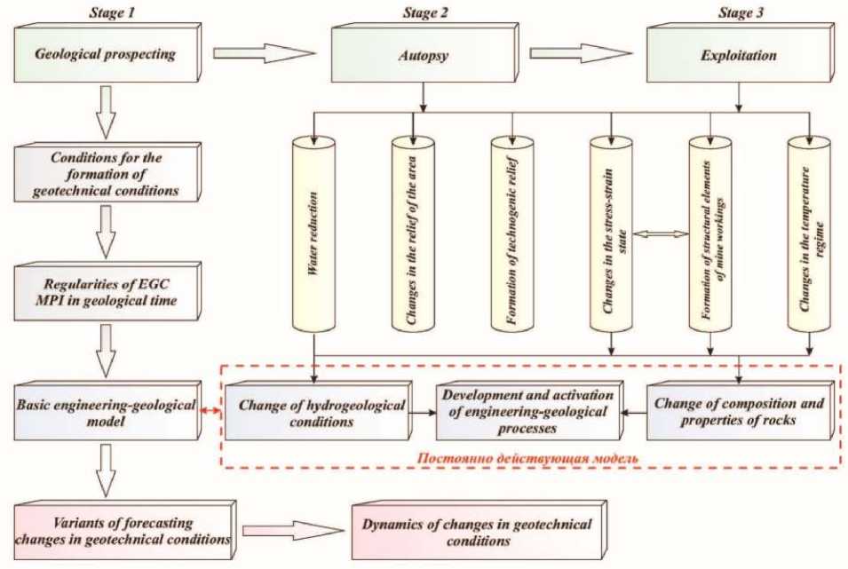
The study of the engineering-geological conditions formed in the geological time at the deposits should be carried out in stages corresponding to the regulations for the study of mineral deposits.
The first stage is the search and exploration of mineral resources. The stage is responsible for studying the conditions of the EGC formation and includes physical-geographical, geological-structural, lithological-petrographic, permafrost-hydrogeological, and geodynamic parameters.
The data obtained are analyzed and systematized. The main factors influencing the conditions for commissioning the deposit are established, and the patterns of their change are revealed. Consequently, a database is formed and
a basic geological engineering model of the field is built. On the basis of the obtained regularities, variants of models for the change in the EGC at the opening of the field are developed ( McLean, Gribble, 2005 ).
The second and third stages are the opening and exploitation of deposits. The stages are responsible for obtaining information about the state of the rock mass and the dynamics of the development of geotechnical processes. The obtained data supplement the basic model of EGC, and the options for the development of EGC are played again that allows you clarifying the fore- cast of changes in the EGC to make management decisions (Waltham, 2014).
During opening and exploiting mineral resources, the impact on the geological environment is manifested in the form (Fig. 1):
-
• dewatering;
-
• changes in the terrain;
-
• changes in temperature conditions;
-
• changes in physical and mechanical
properties;
-
• changes in the stress-strain state;
-
• development of engineering and geo
logical processes.
Stage 3
Exploitation
Постоянно действующая чш>е.1ь
Stage I
Stage 2
Basic engineering-geological model
' Change of hydrogeological conditions
I h if
Geological prospecting
Conditions for the formation of geotechnical conditions
Regularities of EGC MPI in geological time
Autopsy
Development and activation of engineering-geological processes
Dynamics of changes in geotechnical conditions
Variants of forecasting changes in geotechnical conditions'
Change of composition and properties of rocks
Fig. 1. Changes in engineering and geological conditions at the stage of study and development
Results
Let's consider the dynamics of changes in engineering and geological conditions at a number of objects.
Chromite deposit Central (Polar Urals). The study of EGC at the first stage showed that the rock massif bearing the deposit is composed of strong and medium-strength dunites and weakly fractured harzburgites. The rocks are classified as frosty with temperatures (-1.5) - (-2.0) ° С. Hydrogeological conditions are determined by the presence of a thin, seasonally existing horizon of suprapermafrost waters. The main factors of the geotechnical conditions of the field, providing the possibility of the development of geotechnical processes, are the presence of zones of weakening of two types. Systemic fracturing represents the first type. The orientation of the fracture systems coincides with the directions of the fall of the western, southwestern and northwestern pit walls. The surfaces of such cracks are covered with crusts of serpentinite, talc, and kemmerretite. They are characterized by low specific cohesion, which drops to "0" at water saturation.
The second type is pr esented b y zones of fr ag mented r o cks with a blocka g e of 2 to 5 cm. Such zones are confin ed to z ones of tect onic faults ( Zvonarev, 2020 ).
Commercial development of the deposit's reserves began in 2004 and completed in 2017 at a depth of more than 200 m. At the first stages of the opening of the deposit, engineering and geological processes began to form in the sides of the quarry – the collapse of blocks along slip planes, according to the principle of overturning and a tectonic wedge, which led to the «stratifi-cation» of the ledges and the formation of a non-working ledge of 45 m high. Changes in permafrost conditions around the open pit are manifested in an increase in the depth of the seasonal thawing layer. The mark increased from a depth of 3.5 m to 6.0 m due to the opening of cracks and the formation of new ones. After the end of the operation of an open pit at a depth of 200 m, in an area of 0.5 km2, an edge zone was created with a width of up to 120 m, where the degree of fracturing of rocks increased, and nagging cracks are formed. The walls of the open pit are actively damped. The engineering and geological processes began to develop scale and affected all sides (Fig. 2).
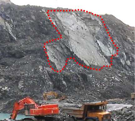
Fig. 2. Sli di ng mirr or, a ft e r shi ft i ng ledges
Thu s , the cons tr uction of a quar r y l ed to following changes in EGC:
-
• an incr e as e in the de g r e e of f ractur in g of the r ock mas s , due t o bl as ting an d a change in the stress-str ain s tate, acti vation of f r os t weathering;
-
• chan g es in the d ept h of the laye r of s e a
sonal thawing;
-
• development of large- sc ale engineering and geological processes.
T he development of the Kur os an depos it , located in the South U r al s , is ca r r ied out in an open pit. At th e s t a ges of ex plor ation, it was e stablished:
-
1. two-s tor ey s tr u ctur e of the r ock mas s if : the lower structural level is compos ed of ef fus ive r ocks and their p y r oclas tic diff erences -quart z and f els itic albitoph yres , which ar e inte rbedded with diabase, and the r ocks are altered
-
2. rocks are characterized by varying degrees of strength from medium to low, intensely fractured and sheared;
-
3. the rocks of the lower level are intensely sheared and fractured;
-
4. as a result of weathering processes, ancient eluvial formations were formed - loams, variegated clays, overlapped from above by clay formations of the Svetlinskaya suite (Bobrov etc., 2018).
by dynamometamorphism and metasomatism processes to the state of quartz-sericite schists, quartz-chlorite-sericite schists;
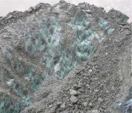
Zones of crust sheathing and weathering formed zones of weakening. During the period of development of the deposit, in the zones of weakening established at the stages of exploration, the formation of significant-scale landslide movements begins, which currently affected the road and the power line (Fig. 3). The depth of the quarry is 70-100 m, and the near-edge zone, in which the back-hole cracks are formed and the landslide develops, increased the diameter of the quarry by 50 m. The dumps located directly on the side of the quarry also contribute to the activation of landslide movements.
Thus, the dynamics of EGC is clearly expressed in a change in the natural and formation of technogenic relief, a change in the stressstrain state (SSS) of rocks, a change in the composition, state and properties of rocks, and the development of geotechnical processes (IGP).
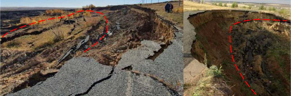
Fig. 3. Formation of catenary cracks and landslide body
Deposits Kaban I, II, III, V, VII are located within the Kabanskaya ore-bearing strip (Northern Urals). Their development was completed in 1964. The project envisaged a combined method of mining at Kaban V and I and an underground method at Kaban II, and Kaban V. It was supposed to build independent mine complexes. In fact, the construction of the shaft was not carried out. As a result, at present, there is an exploration mine at the Kaban II deposit and a complex of underground mine workings connecting Kaban V, which has been practically completely worked out in a combined way to a depth of 90 m, and the currently worked Kaban I.
In the immediate vicinity of the open pits, there are dumps in which substandard copper-pyrite ores are found in large quantities. Because of their hypsometric position, the quarries are a receiver of underground, surface and dump waters. In modern conditions, a dynamic balance has developed between the inflow of water into the quarry and the outflow of acidic (pH = 2-3) mine water. The outflow of water from the quarries occurs along three logs in the northeastern direction. Here, along the entire length of the stream of unloading quarry waters, forest vegetation has been significantly destroyed.
From an engineering-geological standpoint, the rock massif of the deposits has a two-story structure. The lower floor is composed of quartz-sericite schists and albitophyres of medium strength and strong upper eluvial formations.
Eluvial formations are represented by loams and clays with inclusions of strongly weathered debris. Above the ore zone, quartz and pyrite granules and cavernous semi-rocky brown iron ore rocks stand out.
For the period of 2011, the survey of the Kaban V open pit showed the development of engineering and geological processes. The intensification of all types of collapse is associated with surface and groundwater entering the quarry, as well as modern weathering processes ( Pisetsky etc., 2016 ).
The performed geotechnical survey of the open pit showed the development of geotechnical processes, and deformations are characteristic of the upper benches. The main types of deformations are (Bell, 2013):
Muds cover landslides - the sliding surface looks like a smooth curve in the lower and middle parts, and at the top it ends with a vertical separation crack. Such landslides are caused by surface waters, which increase the water saturation of the rocks.
Gullies – the formation of which is associated with the erosional activity of surface waters. Both single and entire systems of parallel gullies are noted (Fig. 4).
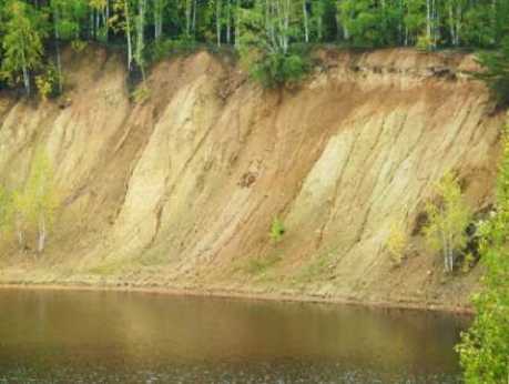
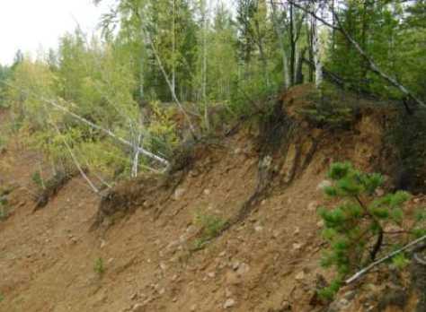
Fig. 4. G u ll ies ( l ef t) and l a ndsl ide ( r ight ) in th e s ide of the quarr y . K aban-V deposit
T he analys is of the dyn amics of chan g es i n h ydr o geolo g ical and eng ineer in g -geological conditions s howed: a change in the chemical composition of water due to the active inf lux of dump water s and ox idati on pr oces s es in the quarry, the dev elopment of eng in eer in g-geol o g ic al pr oces ses that incr eas e the s i z e of the quarry du e to s lidi ng pr o ces s es , a chan ge in the comp osition of s oi l an d veg etation ( Mokhtari, 2019 ).
Drazhnoe deposit . T he depos it ter r itory is located within the Oy m yakons ky ulus of the R epublic of Sakha ( Yakutia) . T he r elief is low-mountainous , g ently s l o ping with abs olute elevations f r om 740 to 125 0 m. T he depos it is l ocated in the zone of continuous per mafr os t, with a thicknes s of mor e than 300 m and r ock te mperatures (-6 °) - (- 9 °) . In the g eolo g ic al s tr uctur e of the f ield, ther e a re two s tr uctur al l evels : the upper one, compos ed of dis per sed r ocks of var y in g d e g r e es of i ce content and ice. T heir complex f acies replacement, both in depth and later ally, the imposs ibil it y of their dis s ection was the reason to call them « i c e com plex» ( Ka-labin , 1960).
T he lower laye r is repr e s ented by s i lts tones of the Upp er T r i as s ic, s ilicif ied, low -strength, medium- s tr eng th and s trong , fr os t y.
T he s tr uctur al featur es o f the lower s tr uctural f loor hav e pr onoun ce d f eat ures of anis otr opy and heter o geneity due t o t he de g r e e of fr acturing , fr a g mentation, sh ea r ing o f r o cks , t he p r e sence of unf avo r ably o r ie nted zones and s ur f aces of weakenin g , and the mor phology of the walls of cracks.
The structural-tectonic structure of the field is characterized as mosaic, in which structurally heterogeneous areas are separated by zones of crumpling or areas of increased fracturing and fragmentation. Against the background of the general northwestern strike of rocks with mo-noclinal bedding, areas of steep submeridional strike, folding with undulating hinges are distinguished. Steeply dipping brittle-plastic zones and zones of weakening complicate the folded bedding. Displacements of small fractures are interspersed with areas of shearing of rocks ground to thin tectonic clays and are accompanied by zones of brecciation and cataclasis with a thickness of 0.5 to 1.0 m. Zones of shear are often confined to the crest parts of small anticlinal folds, where siltstones are transformed to clay ( Nugmanova, 2019 ).
The complex geological and structural features of the field rock mass at the stage of geological exploration indicated the need to take it into account when choosing the slope angles of the pit walls.
Since 2014, the rock massif of the deposit has been mined by an open pit. At the moment, the depth of the open pit is 100 m, and the occupied area is 0.7 km2.
Dumps with an area of 5.2 km2 and a height of up to 40.0 m are accumulated on the surface.
The survey of the open pit in 2019 showed the dynamics of the change in the EGC, expressed in the intensive development of significant talus, which in the upper zone of the open pit almost completely cover the safety berms, the presence of systemic fracturing accompanied by slip mirrors and coinciding with the fall of the pit walls, leads to the formation of falls (Fig. 5), sliding blocks making the operation of mining equipment and people unsafe (Shinka-ryuk, 2013).
Around the quarry, a near-tip zone with a width of up to 50 m has been formed, where the natural stress-strain state of the rocks is changed and back-hole cracks develop.
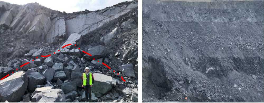
Fig. 5 . Formation of collapse of sides along the surface of cracks (left) and debris in the side parts of the Drazhny open-pit mine (right)
The opening of existing cracks and the formation of new ones led in the spring-summer period to a change in the permafrost-hydrogeological situation and the accumulation of surface waters in the quarry.
Ice aggregation occurs in the accumulated dump masses, which changes the physical and mechanical properties of rocks and can contribute to deformation of the dumps.
Conclusions
Thus, the analysis of the engineering-geological conditions of mineral deposits at the exploration stage made it possible to establish the main factors that determine the conditions for opening up the deposits. However, failure to comply with design decisions during mining leads to unpredictable dynamics and development of engineering-geological processes, which are expressed in changes: absolute elevations of the relief; physical and mechanical properties of rocks; the degree and nature of fracturing; change in the depth of the layer of seasonal thawing; degradation and aggregation of permafrost occurs; geocryological conditions are changing.
The reaction of the geological environment is not long and is expressed in the development of large-scale engineering and geological processes. Therefore, even at the early stages of the study of mineral resources (prospecting and exploration stages), it is necessary to obtain information about the EGC of the field, develop options for the behavior of the models of EGC during their operation in order to minimize the manifestation of negative situations.
References Dynamics of engineering and geological conditions of mineral deposits (from exploration to exploitation)
- Abaturova I.V. et al. 2017. Problems of obtaining geological information during engineering and geological surveys. In: Proc. of 13th Conference and Exhibition Engineering Geophysics, pp. 1-5. DOI: 10.3997/2214-4609.201701984 EDN: XNMYTZ
- Gang L., Zhiqiang Y., Yao G.Q.M. 2013. Research on Engineering Geology and Exploitation Technical Condition of the Deposit in South Area of Sijiaying Iron Mine. Metal Mine. 8:3.
- Naumov V.A. 2010. The concept of managing the formation of deposits on the example of technogenic placers of gold. Natural and technical sciences. 2:262-265. EDN: MBDBLB
- Radwanek-Bqk B., Sobczyk W., Sobczyk E.J. 2020. Support for multiple criteria decisions for mineral deposits valorization and protection. Resources Policy. 68:101-795.
- McLean A.C., Gribble C.D. 2005. Geology for civil engineers. Publication of: Allen (George) and Unwin, p. 348.
