GIS and satellite remote sensing for archeology: exploring polar history
Автор: Goncharov A.E., Karelin N.M., Mednikov D.M., Nasyrov I.R.
Журнал: Сибирский аэрокосмический журнал @vestnik-sibsau
Рубрика: Авиационная и ракетно-космическая техника
Статья в выпуске: 4 т.17, 2016 года.
Бесплатный доступ
The development of archeology in the second half of the twentieth century has received new impetus thanks to the emergence of a new tool - remote sensing, which began its development with the help of satellite technology. Images from space have allowed detecting archaeological sites, the location of which has not been possible to establish other ways. Initially, the new technology was advancing in the framework of state programs in different countries (USA, France, India, Russia and others.). Subsequently, a number of private geo-information services, such as Google Earth, Wikimapia, which significantly simplified access to the technology by all comers. Both small research teams and enthusiasts had the opportunity to use the services of satellite technology in their investigations. The downside of this technology can be used by looters and pseudoarcheologists. Modern geographic information systems have global reach, but different regions are of a different capacity. The northern territories of the Krasnoiarskii krai are reflected in open-access satellite imagery the resolution of which is not always sufficient enough to contribute to research. This results in the need for high-precision satellite imagery. Likewise, it is still necessary to perform field investigation to establish the concrete position of a historical site. This article discusses the use of open-access satellite imagery in studying a number of historical sites and objects (shipwrecks) related to the history of polar exploration on the lower Yenisei and the delta of this river.
Satellite remote sensing, archeology, historical sites, yenisei, northern sea route, polar history
Короткий адрес: https://sciup.org/148177659
IDR: 148177659 | УДК: 528.344:629.783:656.6
Текст научной статьи GIS and satellite remote sensing for archeology: exploring polar history
Introduction. Since their appearance in the late 1950’s, satellites have found application in various fields of scientific investigation. An active consumer of remote sensing technologies is archeology. Remote sensing in archeology has limited application. It is chiefly narrowed to the viewing of satellite imagery for the detection of man-made objects or anthropogenic changes to the landscape; this may include the exploitation of geoinformation (GIS) systems, geophysical scanning or any type of remote sensing data [1]. Most often the sought object comes in the form of buildings, ruins, roads, irrigation canals, traces of farming, etc. satellite remote sensing has been intensely developing during the last few decades and has, thus, offered earth sciences new opportunities for studying the surface of the planet. Beginning from the 1980’s there has been discussion on this matter in academic circles [2; 3]; this topic is still intensely upon reviewed today, making it a key flash point in archeological practice [4]. During this period the database of satellite imagery has dramatically increased, as has its quality and diversity. Currently there is an enormous collection of satellite images that fully cover the surface of the Earth; many areas have been covered multiple times. There are various software systems for viewing and processing satellite imagery, many of which employ their own system of satellites. Many programs are developed as national systems: SPOT (France), IRS (India), Landsat (USA), Resurs-0, Resurs-P, Resursk-DK, Kanopus (Russia), etc [5].
GIS for archeology. There are multiple geographic information systems that provide access to satellite imagery to the ordinary user. The most popular, without doubt, are Google Earth and Wikimapia; two these systems have found the broadest application not only as a recreation project, but for many scientific investigations. However, neither systems are pioneers in providing satellite imagery to a wide circle of consumers, nor do they hold a firm position as to providing high-resolution imagery. Their main advantage is open access, simplicity of operation and a reasonably good image quality that satisfies the majority of ordinary consumers. The highest resolution imagery is provided by the Corona database, which has been assembled between 1957 and 1972 as a CIA and US military project. The images have been declassified between 1996 and 2002. There are approximately over 900.000 images of the planet’s surface in the collection of Corona. Each image is subdivided into 4 squares marked by indexes a , b , c and d ; each fragment has a size of 33.568×10.563 pixels (354 Mb) [6]. The photographic films are stored in the US National Archives and Records Administration, where they can be ordered for copying and scanning. After an image has been scanned, it is transferred into a database with open access, becoming, thus free for other users.
In 2004 Google acquired the startup Keyhole Inc., which had developed a geographic information system called Earth Viewer. Within a year it became globally recognized as Google Earth. The software was available in three packages: Standard was free, Plus and Pro cost $20.00 and $400.00 respectively. In 2015 all three variants of the software became free. A key advantage of the program is its global coverage. Users may scale desired images from 1.000 km to 10 m in 1 cm. However the resolution drastically varies for different areas. The more settled an area is the more chances there are to get a high-resolution view of it. On the contrary, rural areas tend to have a lower resolution quality. Speaking about archeological research, it is worthwhile mentioning that Google Earth enables the user to work with layers of images and save the results of research in an authorized account. This is critical to reduce the chances that looters will be able to get access to archeological information before legal field investigations have been launched.
The technology behind Google Maps, which has been the basis for Google Earth, was also used in the 2006 project Wikimapia by Aleksandr Koriakin and Evgenii Savel’ev. While Wikimapia has no direct relation to the Wikipedia project, the principal behind filling the map with ‘what I know’ information is similar to the one used in the most popular encyclopedia. The software enables the user to switch between satellites, schematic maps of the area and hybrid versions, which are obtained from satellites belonging to different companies; however the most detailed image is generated by Google and Bing.
Google services use multispectral (pseudocolored) images made by the GeoEye satellite series, launched by Google and the US government [7; 8]. Google’s multis-pectral images have a lower resolution, compared to the highly-accurate Corona imagery. However Corona’s images are panchromatic, making them less informative than images made by Google, despite their resolution. The remote sensing services provided by Google enable the user to analyze the vegetation of the Earth’s surface, the condition of the atmosphere, hydrosphere and the geology, producing, thus, a more accurate result. Black and white (single-channel) images and images with few colors have limited application, causing user to apt for multichannel (colored) imagery from satellites producing high-resolution photographs [9].
An important feature of Google Maps and Wikimapia is the function of obtaining precise geographic coordinates of an object and their further use for working with topographical maps and GPS navigation systems. At the same time, mathematical-cartographic modeling methods and the graphic display of geographically-coordinated spatial data allow the user to receive an understanding of the geometrical parameters of an object.
Satellite imagery enables an archeologist to identify typical markers for archeological sites. Shadows cast by vertical objects (especially in areas with a flat terrain such as the tundra), former excavations, ditches, walls, buildings and other objects with visible geometrical shapes are examples of such markers. Depending on the position of the sun, various objects such as tranches or earth mounds can be distinguished. Alterations in the vegetation of a specific are may also indicate to the presence of a historical site within a specific area. Thus it is possible to identify an archeological site using only satellite remote sensing methods; however, to verify such a hypothesis it is still necessary to be in person at the proposed location of a historical site [10; 11]. This said it is necessary to conclude that satellite imagery alone cannot be used to ascertain the presence of an archeological site.
Satellite remote sensing has found broad application in archeology, paleonthology, geology, environmental sciences and other disciplines since the 1990’s. Due to the high cost of the images, their usage was limited to major research facilities and universities. Google’s open-access policy has revolutionized the use of satellite imagery, making it accessible even to under-financed research projects. Satellite imagery has found application not only for detecting and identifying historical sites, but for their conservation [12].
Satellite remote sensing and polar history on the river Yenisei. Using Satellite remote sensing for marine archeology was discussed in [13]. However we have not found any reference to the wide usage of this method for identifying historical sites related to polar history of the nineteenth and twentieth centuries in the Russian Arctic. We are specifically discussing the history of the Northern Sea Route and adjacent river navigation.
In 2015 and 2016 Reshetnev Siberian State Aerospace University (SibSAU) together with the Russian Geographical Society (its expedition center in the Siberian Federal District) organized an expedition under the name ‘Where Thames meets the Yenisei’. The expedition covered the areas of Eniseiskii raion (Eniseisk District), Turukhansii raion (Turukhansk District) and Taimyrskii raion (Taimyr District) of the Krasnoiarskii krai. The key objective of the expedition was to establish the location and state of a number of historical sites relevant to polar exploration and shipping on the Northern Sea Route in the last two centuries. The preparatory period of the expedition included the research of a large amount of historical records, including topographical maps and charts of the Yenisei and its mouth. Using satellite imagery allowed the team to establish a number of sites on the map, the location of which had been unclear in existing polar literature. Due to limited funding, the project team used open-access satellite imagery. As this area has not been focus of significant interest among researchers, images of it are not found on Corona’s free database.
A visual analysis of multispectral high-resolution images, the position of shadows and vegetation markers, geometric parameters of the objects and their configuration allowed the team to make suggestions about the presence of a number of sites (discussed below). Unfortunately, the images provided by Google for this area are of rather low resolution (the average scale in 1:50 000).
The east bank of the Yenisei to the north and east of 71°52′43′′ N, 83 ° 08′20′′ E has a significant drop in the image quality of Google’s services (from 1:2500 to 1:100 000). The highest resolution for this area is provided by Bing satellites.
In this research we have analyzed satellite imagery made by the aforementioned Google services with resolutions of 1:2000, 1:5000 and 1:50000. The results have demonstrated that this scale is insufficient for indentifying all the historical sites found during the expedition. To illustrate this point we shall show a satellite image and a photograph from the earth for each location.
In 2015 the first stage of the expedition took place [14; 15]. The team traveled a distance from the town of Eniseisk to the settlement of Bor at the confluence of the Yenisei and Podkamennaia Tunguska, performing various historical research enroute. Among the archeological sites marked by the team was the island of Feniksova kosa, where in 1892 the steamer Phoenix , formerly belonging to the British Phoenix Merchant Adventures Co., was wrecked. It was recorded that the vessel was lost, but no further mentioning of its fate or condition was found in historical literature. During the expedition it was established that the island, which had been a sandbar before the incident has ‘grown’ on the steamer, covering it with a layer of sand. According to the local pilot service, parts of the vessel are visible in low water.
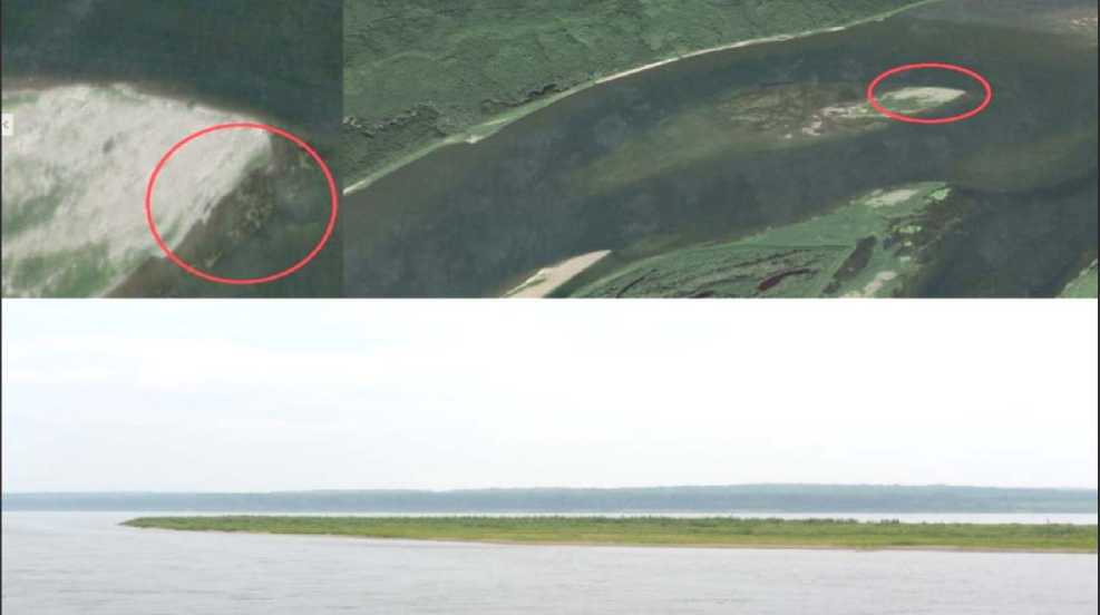
Fig. 1. The island Feniksova kosa, the Turukhanskii raion (Turukhansk District) of the Krasnoiarskii krai, 61°23′43.5″N, 89°42′18.9″E
Satellite imagery of the island has revealed no information on the vessel (fig. 1). At the same time, a nearby island contains a wreckage of a Soviet-era barge that has also been covered by a massive layer of sand. However, as parts of the superstructure of the vessel are visible during the high-water mark, the object is recognizable on satellite images. Since the water level in the Yenisei is influenced by various natural and anthropogenic factors, it is difficult to select the correct time for field research. In situ observations are also complicated due to the remoteness of the area. Consequently, in order for researchers to detect such objects and select the proper archeological methods, it is necessary to have at their disposal a series of multispectral satellite images made during different years and months (when the river is free of ice).
In 2016 the expedition was continued: the team covered an area from Turukhansk to the estuary of the Yenisei, recording historical sites and accessing their prospects for further archeological research. One of the sites was at the confluence of the Yenisei and Kureika rivers. The GIS Wikimapia map marks his location as an abandoned settlement (fig. 2); the maximal scale of the image is 1:5000. During the late 1800’s – early 1900’s there was a settlement here built by the infamous goldminer and organizer of polar expeditions Mikhail Sidorov. This part of the river served him as a headquarters for his graphite mining enterprise. During the winter of 1876–1877 the crew of Joseph Wiggins’s schooner Thames wintered at this location. A study of the site revealed multiple evidence of human activity, including the timbers from buildings. The terrain and thick vegetation made it impossible to establish the concrete borders of the site due to a tight schedule. While Google’s images provide us with some clue of human activity in this location (a large clearing, signs of building foundations), it is necessary to use high-resolution images with different spectral range to further investigate this area remotely. Various spectral ranges will enable researches to view the same location without vegetation, determining the terrain and, thus, the site’s perspective for archeological excavations.
An interesting find, using satellite remote sensing imagery and comparing it with on-earth investigations is a shipwrecked barge (or lighter) in located in the vicinity of the settlement of Karaul in the Taymirskii raion (fig. 3). The history of this barge has not yet been determined; however it is worth suggesting its construction date within the first half of the twentieth century. The vessel has a maximum length of approximately 70–80 m and a maximum width of 10 m. The remaining part of the vessel had been built from Siberian larch. The part of the vessel that it subjected to foundering and is in constant contact with water has the best decree of preservation. Its stern section is covered by sand at the limits of the vessel are not seen from the ground. A satellite image, in its turn, provides us with information on the borders of the barge and the shape of its stern, which is not visible on the ground. The satellite image for this particular location was scaled 1:2000.
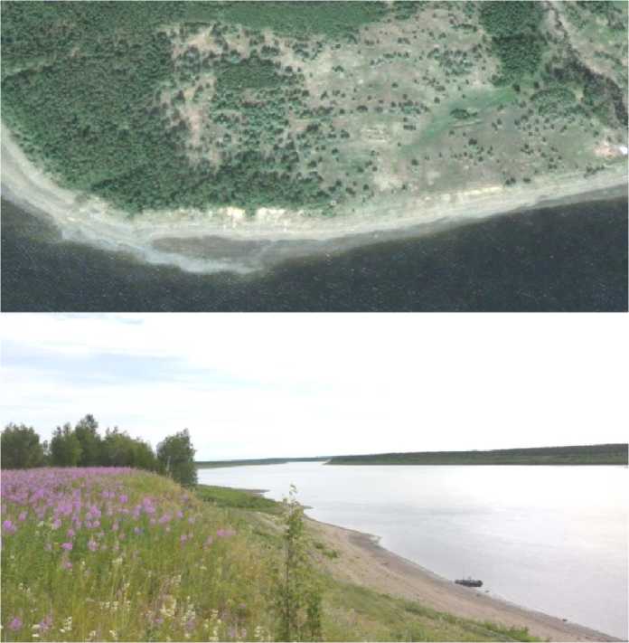
Fig. 2. The confluence of the rivers Yenisei and Kureika, the Turukhanskii raion, 66°29′32.6″N, 87°13′35.9″E
During the course of polar history, various Siberian settlements played an important role as ports and expedition bases. During the Soviet era and further into modern history, many villages were abandoned by their inhabitants. As afore mentioned, man-made structures such as houses and their ruins are often visible from space as they cast shadows or dictate vegetation grown in a certain manner or direction. It is, thus, possible to determine the geometry and configuration of an object using these markers. While the resolution of open-access satellite images does not always allow researchers to conduct any critical analysis without filed work (as with fig. 2), in some cases this resolution is enough. An example of a successful comparison of a satellite image (scale 1:2000) and field investigation is demonstrated in fig. 4. Satellite imagery revealed a group of ruins on the mys (cape) Tol-styi Nos. A visual study of the ruins produced 8 buildings (their foundations). As seen from fig. 4, the buildings are situated in a specific order – forming a ‘street’ with 5 buildings on one side and two buildings on the other. The ruins of one building are located at a distance from the others (possibly a church). The ruins consist of parts of the foundations, roofs and stove masonry. These details are not visible on the available satellite images.
As aforementioned, the further the satellite image (open-access) is made from highly-populated areas, the greater the chances that the image will not have an appropriate resolution. Thus, if at Tolstyi Nos the scale of the GIS-map is 1:2000, a move just 50 km north significantly decreases the scale to 1:500000. This inevitably affects the amount of data we can acquire from a satellite image as it becomes too schematic and it is impossible to distinguish separate details of an object or even identify it. The expedition team discovered a shipwrecked vessel at the Bol’shoi Brekhovskii ostrov (island) in the delta of the Yenisei. As the vessel is similar in its construction to the one at Karaul, it was proposed that it was another barge, but of lesser size (length 20 m, width 4 m). Its condition is far worse than that described in fig. 3 as it is located in a wetland environment (only part of the side and bottom is preserved); this brought the team to a now rejected hypothesis, that this was the wreck of a nineteenth-century schooner. Knowing where the vessel is, it is possible to see its features on a GIS image by Google. A higher resolution image would, certainly, have been very useful for researchers in this situation.
Another issue worth mentioning is that geographic information systems often provide the user with unsuitable images for performing any type of research, for example satellite images made during the winter.
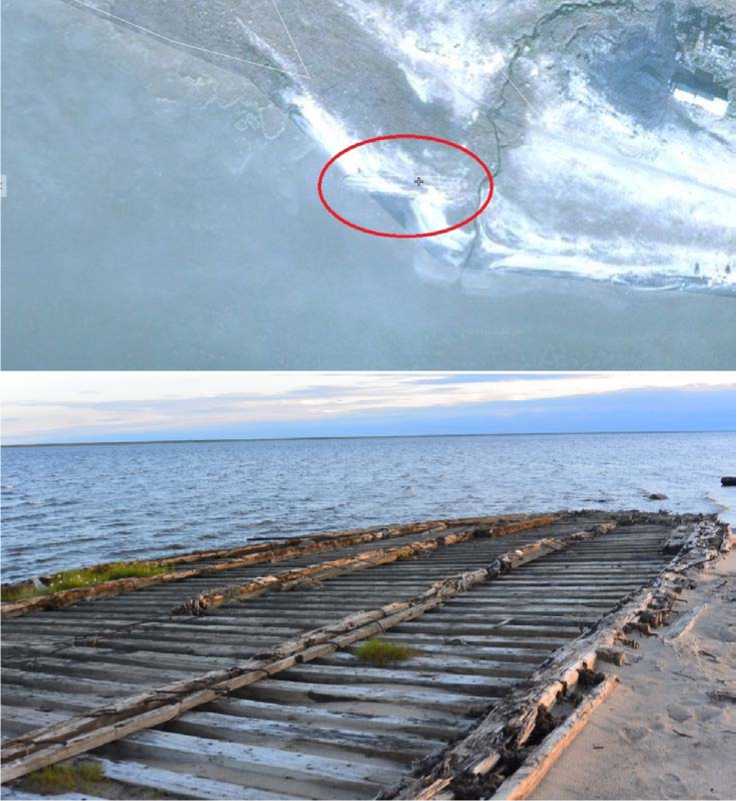
Fig. 3. Shipwrecked barge (or lighter) at the settlement of Karaul, the Taimyrskii raion (Taimyr District) of the Krasnoiarskii krai, 70°04′11.1″N, 83°10′46.7″E
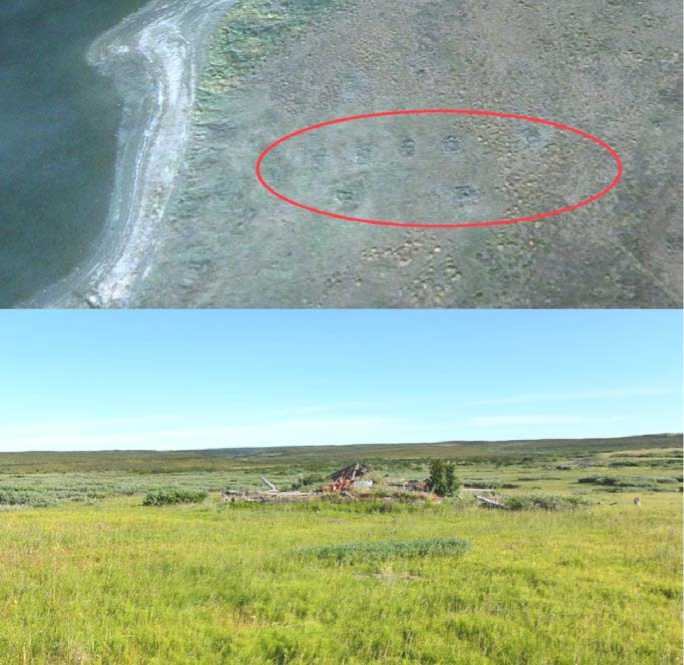
Fig. 4. Ruins of the settlement of Tolstyi Nos. Mys Tolstyi Nos, Taimyrskii raion, 70°12′07.9″ N, 83°04′39.6″ E
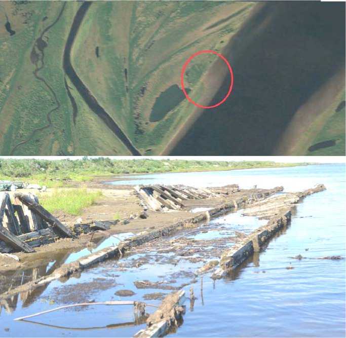
Fig. 5. Wreckage of an unidentified vessel (presumably, a barge).
The Bol’shoi Brekhovskii ostrov (island), Taimyrskii raion, 70°40′32.9″N, 83°04′915″Е
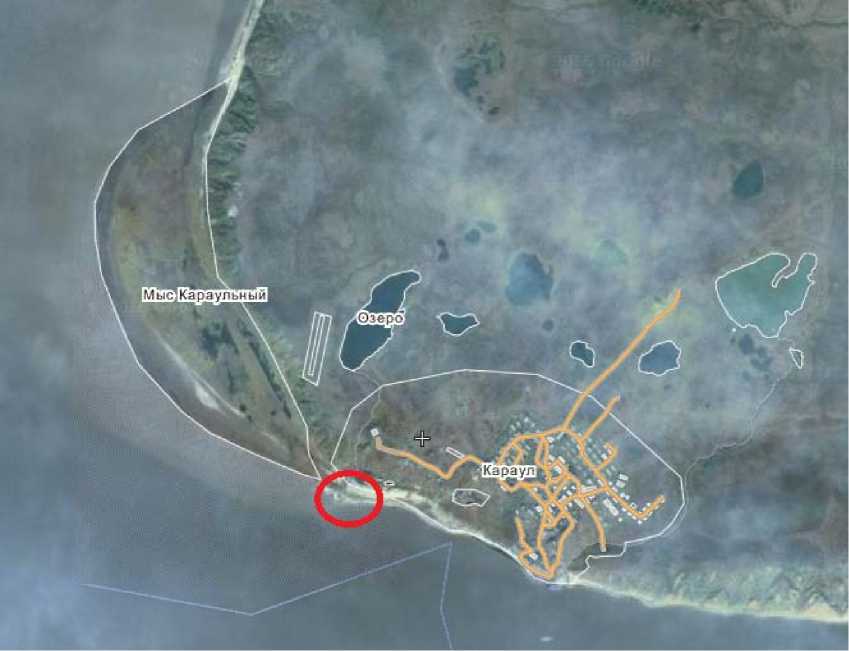
Fig. 6. Satellite image of scale 1:50000. Same coordinates as fig. 3. Wreck of barge encircled
Conclusion. Thus, the usage of open-access multis-pectral high-resolution images for polar archeology has demonstrated us a satisfactory result. If the image can correspond to a map with a scale of 1:2000, it is possible to identify man-made objects and the presence of human activity in a specific location. In this research it was necessary to ascertain the state of historical sites with field investigations (fig. 3, 4). The analysis of GIS maps is difficult do to the large area of the covered region, as areas of hundreds of square kilometers have to be viewed. However, high-definition imagery from remote sensing systems significantly contributes to the research. Using them as a cross reference with historical literature, historical records and topographic and other maps allows researchers to determine the exact location of specific historical sites and their condition. At the same time, the higher the zoom, the easier it is to analyze the images by determining the aforementioned set of markers, determining the human impact on the environment. However field research is still paramount, as it is often easy to confuse natural phenomena with human activity, especially if the researcher wants to demonstrate his desires for facts. If the scale of an image is increased, its information capacity will be significantly reduced (fig. 1, 2, 5). They become more schematic and do not allow the user to distinguish even large objects (compare fig. 3 and 6).
It is also necessary to note that the development of open-access satellite imagery services assists not only professional researchers and archeologists working on a legal basis [16], but those individuals who loot historical sites for the merit of their own profit. Thus, it is not always reasonable to make high-resolution satellite images open to the public.
Acknowledgments. The work is supported by grant of Russian Fund of Humanities and the Krasnoyarsk Regional Fund of Science, application number 16-11-24010.
Список литературы GIS and satellite remote sensing for archeology: exploring polar history
- Parcak S. H. Satellite remote sensing for archaeology. New York, 2009. P. 306.
- Allan J. A., Richards T. S. Use of Satellite Imagery in Archaeological Surveys. Libyan Studies. 1983, Vol. 14, P. 4-8.
- Tsutskin E. V., Elina A. I., Elin M. L. . Pamyatniki Kalmykii kamennogo i bronzovogo veka. Elista. 1982, P. 54-58 (In Russ.).
- Arkheologiya i geoinformatika. Pervaya mezhdunarodnaya konferentsiya . Moscow, IA RAN, 2012, 52 p. (In Russ.).
- Tokareva O. S. Obrabotka i interpretatsiya dannykh distantsionnogo zondirovaniya zemli . Tomsk, Izdatel’stvo Tomskogo politekhnicheskogo universiteta Publ., 2010, 148 p. (In Russ.).
- Garbuzov G. P. . Rossiyskaya arkheologiya. 2003, No. 2, P. 45-55 (In Russ.).
- Geoeye-1: the world’s highest resolution commercial earth-imaging satellite. Available at: http://content. satimagingcorp.com.s3.amazonaws.com/static/satellite-sensor-specification/GeoEye-1-PDF-Download.pdf (accessed 10.11.2016).
- Crespi M., Colosimo G., De Vindictis L., Fratarcangeli F., Pieralice F. GeoEye-1: analysis of radiometric and geometric capabilities. Personal Satellite Services: Second International ICST Conference, PSATS. 2010, P. 354-369. Doi 10.1007/978-3-642-13618-4_27.
- Bagautdinov R. S., Kopenkov V. N., Myshkin V. N. . Informatsionnye tekhnologii i nanotekhnologii. Materialy Mezhdunarodnoy konferentsii i molodezhnoy shkoly. Samara, 2015, P. 318-323 (In Russ.).
- Google Earth na sluzhbe arkheologov (In Russ.). Available at: http://www.razdory-museum.ru/ns_google-helps-archaeologists.html (accessed 10.11.2016).
- Google Earth v pomoshch’ arkheologii (In Russ.). Available at: http://googlehot.ru/maps/google-earth-v-pomoshh-arxeologii (accessed 10.11.2016).
- Kenig A. V., Zaytseva E. A. . Interekspo Geo-Sibir’. Novosibirsk, 2013, Vol. 8, P. 48-51 (In Russ.).
- Antelo J., Ambrosio G., Gonzalez J., Galindo C. Ship detection and recognition in high-resolution satellite images. 2009 IEEE International Geoscience and Remote Sensing Symposium. 2009, Vol. 4, P. IV-514-IV-517 DOI: 10.1109/IGARSS.2009.5417426
- Wreck of lost 19th century English steamboat found in Siberian river 139 years after it sank. Available at: http://www.mirror.co.uk/news/world-news/wreck-lost-19th-century-english-8606816 (accessed 10.11.2016).
- Ekspeditsiya "Gde "Temza" vstrechaetsya s Eniseem". (In Russ.). Available at: http://ru.arctic.ru/photo/20160811/406291.html (accessed 10.11.2016).
- How Google Earth Has Revolutionized Archaeology. Available at: http://discovermagazine.com/2015/may/20-playing-the-field (accessed 10.11.2016).

