Implement operational actions using digital cards in settlements

Author: Ergasheva Yu., Safarov E.Yu.
Journal: Экономика и социум @ekonomika-socium
Section: Основной раздел
Article in issue: 12-1 (91), 2021.
Free access
One of the priorities of state policy in the field of defense is to increase the effectiveness of protection of the population of our country from various emergencies. The role of the population in the process of population location and territorial organization, production facilities, and public relations with the environment is enormous. It will be necessary to take operational measures within. The article analyzes the complexities of the rapid (rapid) evacuation of the population to a safe area and what should be considered in the professional implementation of their evacuation without casualties and develops recommendations.
Tactical characteristics, emergency, accident, catastrophe, natural disaster, weapons of mass destruction, reconnaissance, intelligence, digital card
Short address: https://sciup.org/140262399
IDR: 140262399
Text of the scientific article Implement operational actions using digital cards in settlements
Introduction. The large-scale reforms being carried out in our country are of great importance for the security and peaceful life of citizens, including the military sector. There is a great need to use the latest generation technologies in the military to ensure the rapid and efficient operation of the industry. In the modern advanced foreign experience in the military field, new methods of using digital cards in the implementation of operational activities are widely used. In recent years, our country has also established cooperation with leading countries in the development of science and technology to increase the military potential of New Uzbekistan. In particular, in cooperation with the CIS countries, military field exercises, various military competitions, exchange of experiences are being carried out. The study and introduction of digital maps in the military field, along with increasing the strength of our National Army, will contribute to the development of the science of military topography.
The tactical features of the area are crucial in combat and emergencies, including in evacuating the population to a safe area. This, in turn, provides an indepth study of the tactical characteristics of the place, and thus to achieve efficiency and superiority in combat situations. In a war situation, there is a need not only to evacuate civilians but also to protect their homes from weapons of mass destruction, natural disasters, accidents, various catastrophes, to develop tasks of rapid and safe movement in the desired direction using maps.
Relevance of the topic. To increase the efficiency of the Armed Forces of our country, to develop effective tactical features that can be used in combat situations, an in-depth study of geographical conditions and settlements is relevant. By the 1990s, the threat of nuclear war had diminished, the use of biological weapons had been curtailed, new types of modern weapons had been discovered, and they were aimed at destroying economic facilities rather than being dangerous to humans. The amount of damage caused by various accidents, catastrophes, and natural disasters in the countries is also increasing. Of course, in such a situation, it is possible to turn the situation in a positive direction by considering all ways to eliminate the damage. Currently, there are interactive maps that are part of the digital maps to study the geographical conditions of the selected area and define the tasks in the area, which are characterized by the fact that you can specify the location, distance to the destination, and time to reach the destination. An interactive map helps you identify landmarks that are close to the area you are looking for on the ground, navigate in different directions, and resize the area. This card is effective in carrying out operational actions in emergencies. However, these interactive maps, like topographic maps, do not show the obstacles, road features that impede the movement of equipment in military operations or emergencies. The inability of the interactive maps to fully reveal the tactical features of the location does not ensure that the combat troops can perform the tasks assigned to them to the maximum extent.
The 3D maps created in the ArcGIS program are characterized by a clear representation of natural and anthropogenic barriers that are difficult to cross. It is important to accurately enter the dimensions of combat machines on 3D maps, to know the essence of the colors used in the graphics program, to pay attention to the mixing of colors. The reason is that the color in the observation and masking of the place hurts the complete study of the place. Of particular importance is the availability of officer cadres who can use 3D cards professionally. In general, it is important to provide military personnel who use cards professionally for combat operations and operational movement of the army in emergencies.
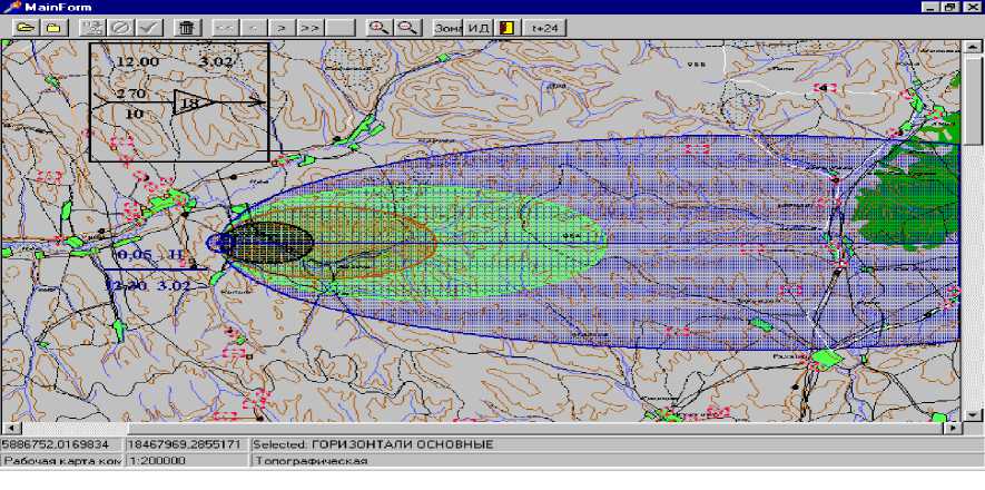
Figure 1. Distribution of radiation on a digital map as a result of the use of weapons of mass destruction on the ground (under the influence of wind)
It is necessary to have in-depth knowledge and skills in distinguishing the characteristics of natural and man-made phenomena in different emergencies, to make quick and clear decisions in the rapid evacuation of the population.
Research Methodology. Theoretical analysis, visual, comparative methods were considered in the study of the work, i.e., historical and modern combat situations were analyzed to more fully cover the tactical features. Maps published in historical and different years; topographic, digital, and three-dimensional maps were visually observed and compared with each other [1. Р. 114].
To increase the effectiveness of the study of tactical features of the place, it is necessary to pay attention to the following:
-
- development of proposals for the selection of suitable positions for the army and equipment, depending on the location, depending on the facilities located in the area;
-
- effective implementation of topographic, aerial photography, digital relief maps with deep tapping, formation of a system of full location of troops and equipment in combat and emergencies, as well as in motion;
-
- Development of methods for studying digital maps for various geoinformation tasks based on location information: rapid movement in unfamiliar areas in combat situations, development of a scheme of movement in safe areas for evacuation, and ensuring its effectiveness.
References Implement operational actions using digital cards in settlements
- Gavrilov A.V., Andreev V.A et al. Military topography. Textbook, 3rd ed. - SPb.:VKA im. A.F. Mojayskogo, 2018. -528 p.
- Gulyamova L.X. Geoinformation systems and technologies. Textbook. -T.: Universitet, 2018 y. Page 187.
- Tojieva Z.N. Population geography. Textbook. -T.: Science and Technology, 2019. 248 P.
- Yudina A.F. Construction of residential and public buildings, textbook. M.: Academy, 2011, 368-p.
- Ivanov V.G., Bashlaev R. Application of geoinformation systems and means of three-dimensional modeling to create 3D models of the area of deployment of elements of the communication system during combat operations - M., 2017, 217 p.
- Ivankov P.A., Zakharov G.V. “Mestnost i ee vliyanie na boevye deystviya voysk” M., Voenizdat, 1969. Str-208. 6. Lure I.K. Geoinformatsionnoe kartografirovanie. Methods of geoinformatics and digital processing of space snapshots. - M.: size-vo KDU, 2008. - 428 p.
- Paul A. Longley, Michael F. Goodchild, David J. Maguire, David W. Rhind. Geographic Information Science and Systems, 2015. 496 pages.
- Plewe B. GIS Online: Information Retrieval, Mapping, and the Internet. - Geoinformation, International, Cambridge, UK, 1997. - 311 pages.
