Indigenous people of the North in the Arctic area of Yakutia: geoinformational research of the settlement in the ХХ century

Автор: Fillipova V.V.
Журнал: Arctic and North @arctic-and-north
Рубрика: Social Sciences
Статья в выпуске: 9, 2012 года.
Бесплатный доступ
It is showed the dynamics of the number of the indigenous people of the North of Yakutia, according to the lists of the Population of the twentieth century and it was constructed the maps of the settlements with GIS technologies.
Indigenous people, GIS technologies, Yakutia
Короткий адрес: https://sciup.org/148320390
IDR: 148320390 | УДК: 061.1:323.1(=1.571.56-81)
Текст научной статьи Indigenous people of the North in the Arctic area of Yakutia: geoinformational research of the settlement in the ХХ century
This article presents the preliminary results of the project RFH № 11-01-12004v "Creating a
GIS" Resettlement of the Indigenous Peoples of Yakutia in the first half of the twentieth century. "The objective of this project is to study the geographical features of the resettlement of the indigenous people of Yakutia by the creating a geographic information system for the decision support and the optimization to preserve the traditional land of the indigenous population. The main object is the system developed GIS settlement of the small population of the North Yakutia, which is the basis for the preservation and the development of their traditional land. Established GIS will help in the solving the land interests of the small population of the North, on the one hand, and the industrial, transportation agencies, on the other. This GIS will also apply the modern cartographic methods of the research to determine the laws governing the formation of the resettlement of indigenous peoples of Yakutia in the twentieth century and to identify changes in the areas where they reside during the study period. Established GIS will help to harmonize the various sources of information (statistics, maps, history, etc.) for the reconstruction of the system of settlement of indigenous people of Yakutia in the first half of the twentieth century.
According this project of the instrumental geo –informative mapping tool allows to: accumulate information about the resettlement of the indigenous people;
Identify the territory occupied by the indigenous people and analyzed their spatial variations; derive synthetic cartographic images associated with the component and integral database.
Also geoinformation mapping can be an effective method for studying the resettlement of the indigenous people of Yakutia, which will allow harmonized and common methodological prin- ciples to create different time thematical (and integral component) map-layers and then using overlay operations, derive map-layers showing qualitative and quantitative changes. This implies that the GIS mapping for studying the dynamics of the territorial distribution of the indigenous peoples of Yakutia.
In the first phase of the geoinformation mapping the dynamics of the settlement of the indigenous people of Yakutia, which was developed GIS structure, consisting of attribute and spatial data. The main sources of information for the developing attribute databases, which are the documents of the historical statistics, archival records and published sources, spatial data - raster and vector maps.
For GIS-mapping resettlement of the indigenous people of Yakutia have been chosen and created the general geographic framework scale 1:15000000 card settlement in the context of ulus (district) and 1:2,500,000 card settlement at the community level. Choice of data scale due to the fact that they are traditionally used for the thematic mapping the entire territory of Yakutia. It is in these scales created practically all open cartographic works Yakutia, which allows comparing the information presented in them.
Using the information, entered in the attribute data in the selected general geographic bases created various times thematic layers resettlement of the indigenous people of Yakutia. Before the introduction of the thematic layer, many materials were pre-treated (reduced in scale, projection), and if necessary - is typology and the graphic generalization due to over-detail maps of the source. Thematic map layers are created as by pre-selected maps, the content of which are wholly or substantially meet the requirements of the project, and on the basis of cartographic synthesis of dissimilar materials, the content of which is original and has no analogues.
A dynamic approach to the study of the spatial distribution of the indigenous people of Yakutia is implemented in the transformation of the heterogeneous information sources and the different times in the same type of the resettlement geo images, accompanied by the same type as the attribute information for the specific time slices (in our case - the census) with further combination and chart analysis.
During the GIS research of the resettlement of the indigenous people of Yakutia in the twentieth century are used the following principles:
use of a single digital single-scale of the general geographic basis with layers: the hydrographic network, terrain, borders, settlements, etc.;
the preparation of multi-thematic layers (settlements, population size of settlements, the number of the minority ethnic groups, ethnic composition, etc.);
-
the application of the common standards in the creating generalization of multi-layers on the same subject;
-
the application of the common quantitative measures and qualitative traits in the formalization of information about objects in the listing on the thematic layers and database;
-
the use of GIS mapping for extremely wide range of competent and reliable sources of information (mapping, statistical, descriptive text);
the application logically sound, expressive, easy to read and comparable graphics tools (for point objects - icons by shape, color and size, for landfills - polygonal characters on both qualitative and quantitative color scales, and for linear objects - linear character of shape, color and size).
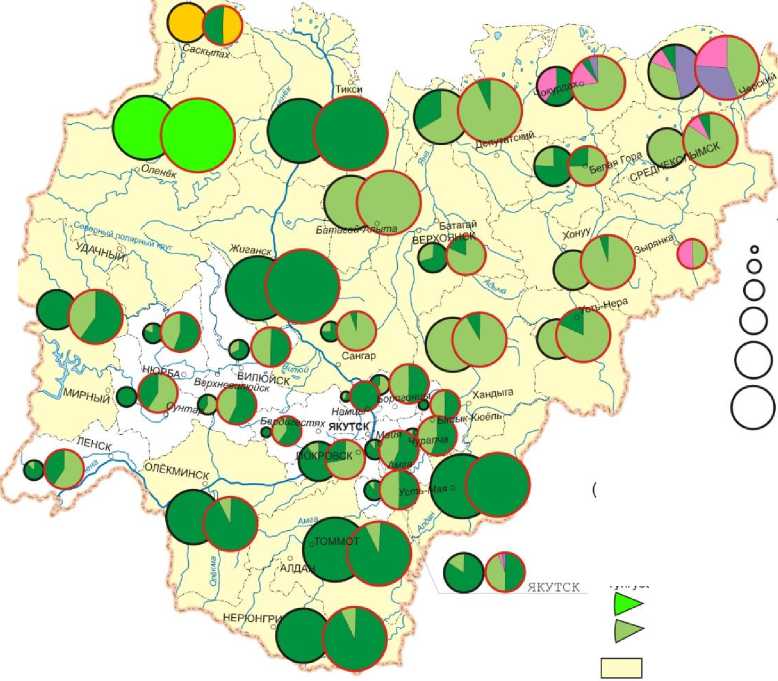
On the basis of the above principles and the population censuses in 1939, 1959, 1970, 1979, 1989, 2002 and 2010, we made a map showing all the resettlement of the indigenous people, who are living in the territory of Yakutia, and their individual representatives - evenkov, evenov, yukagirov, chukchi and dolgan in the scale 1:15000000, examples of which are shown in the figures 1 and 2.
1939 г.
100 - 500
500- 1000
1000-2000
ЧУКОТСКО-КАМЧАТСКАЯ СЕМЬЯ менее 10 10-50
АЛТАЙСКАЯ СЕМЬЯ Тюркская группа ^> Долганы
ЧИСЛЕННОСТЬ КОРЕННЫХ МАЛОЧИСЛЕННЫХ НАРОДОВ СЕВЕРА (по районам, чел.)
Эвены
1989 г.

100 - 500
500- 1000
1000-2000
2000 - 2500
КОРЕННЫЕ МАЛОЧИСЛЕННЫЕ НАРОДЫ СЕВЕРА (по районам, в процентах от общей численности КМНС)

Чукчи
Тунгусо-маньчжурская группа Эвенки
УРАЛЬСКО-ЮКАГИРСКАЯ СЕМЬЯ Юкагирская группа Юкагиры

Районы компактного проживания коренных малочисленных народов Севера по распоряжению Правительства РФ от 8 мая 2009 г. 631-р
Picture 1. The resettlement of the indigenous people of Yakutia, according to the censuses of the population in 1939 and 1989
rc^
Хо'нУУ,
Сангар
'Уандыга
Борогг
'Унтар
Hawi
Сюёль)
Зигестях
IVdi^1
^Б^та^й Ч iEPXO^HCfc <
■■I
Ш ЯЯЯИЙЖйтЯННЯ мняяв _ _^^ ^■■н ЬШИи НИ 8аям!| И ИИ шта
1989 г.
1939 г.
1939 г.
1 -5
5-10
10-20
Эвенки по результатам Переписей населения не зафиксированы или их удельный вес не значителен
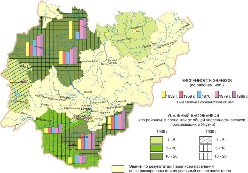
ЧИСЛЕННОСТЬ ЭВЕНКОВ (по районам, чел.)
УДЕЛЬНЫЙ ВЕС ЭВЕНКОВ (по районам, в процентах от общей численности эвенков, проживающих в Якутии)
□ 1939 г. Dl959 г. Dl970 г. Dl979 г. П 1 мм столбика соответствует 80 чел.
5-10
^ 10-20
Picture 2. The settlement of the Evenki in Yakutia on the census data of the population
The main aim of this project is the reconstruction of the resettlement of the indigenous people of Yakutiaat the first half of the twentieth century, at the community level. As an information source to bind communities living minorities of the North Yakutia map chosen different time cartographic works representing raster mapping ensuring created GIS and primary materials census in 1927 and 1939, collected in the National Archives of the Republic of Sakha (Yakutia), the State archives of the Russian Federation, the Russian State Archive of the economy.
On the basement of the synthesis of the collected archival, statistical and cartographic data reconstructed the resettlement of the indigenous people of Yakutia in the first half of the twenti- eth century in the form of the thematic maps made on the scale 1:2,500,000 (Picture 3).
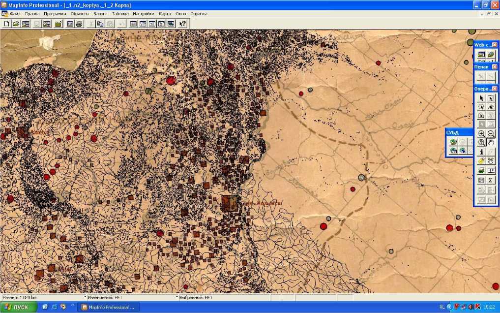
Picture 3. The combination of the raster and vector layers for the reconstruction of the settlement of the indigenous minorities of the North of Yakutia in the Census of 1926-1927 period. The section of the map scale 1:2,500,000
Developed according to the project the information system and created a series of the thematic maps can be used by the researchers who study the territory of Yakutia, and researchers in other regions of the indigenous minorities of the North.
Reviewer – Uliyanovskiy Viktor Ivanovich,
