Indonesian Universities Readiness in Providing Professional HR in Geospatial Information

Author: Indu Purnahayu, Puspa Eosina, Budi Susetyo, Immas Nurhayati
Journal: International Journal of Modern Education and Computer Science @ijmecs
Article in issue: 3 vol.12, 2020.
Free access
The need for geospatial data and information for development planning is major and inevitable at this time. Economic and social development requires the creation of a prosperous society in terms of meeting the adequacy of life and the extent to which environmental sustainability is maintained. The need to achieve both economic and social development goals requires data and information that can be provided by geospatial information. The question is how much is the opportunity that provides benefits for the community responded well by universities (PT) that provide experts in the field of geospatial information? To answer these questions, this research: 1) analyses the PT readiness from the aspect of human resource development in the field of geospatial information; 2) assess how much the ability of universities to provide experts in the field of geospatial information. The results of the study show that PT curriculums in Indonesia are fit with tiers 1 and 2 geospatial HR competencies in accordance with the DOLETA curriculum, and development is needed to meet levels 3 to 9. In terms of HR capabilities of the 41 PTs that carry out geographic education, only 2 PTs produce Geospatial HR. The paper offers e-learning or distance education is one of the approriate solution to fill in the gap between need and availability of Professional HR in Geospatial Information.
Geospatial information, Geospatial competency models, Indonesian higher education curriculum, Geospatial HR, e-learning, Distance education
Short address: https://sciup.org/15017589
IDR: 15017589 | DOI: 10.5815/ijmecs.2020.03.04
Text of the scientific article Indonesian Universities Readiness in Providing Professional HR in Geospatial Information
Geospatial information is a need and interest for various sectors both government and private. According to the deputy of the Geospatial Information Division of the Geospatial Information Agency, 65% of government activities use spatial elements as the main identifier and 90% of government activities have spatial elements[1]. Geospatial elements of information are used as core identifiers to integrate various types of information. The information includes various potential natural resources, disaster events, economic growth, agriculture, population, and other valuable information. By using geospatial technology the information is elaborated and produces various kinds of sharper and comprehensive analyzes. The implications of the use of geospatial technology undoubtedly produce integrated information and provide comprehensive, faster and better problem solving.
Talking about the type of geospatial technology used today, the available geospatial technology is technology related to the collection and processing of data related to location, namely global navigation satellite systems (GNSS), remote sensing, and geographical information systems (GIS). Utilization of this technology in collecting and processing geospatial data and information is proven to be faster and more accurate than tabular data and information models. Behind the strength of the use of geospatial technology and the increasing need for geospatial information for development analysis and planning is the need for the availability of professional and competent human resources based on geographic information systems[2].
Data and information currently available shows that Indonesia even has a shortage of personnel in the field of geospatial information in terms of quantity and quality [3]. The Geospatial Information Agency stated that the need for geospatial information personnel (IG) in 2016 reached 33,414 people while there were 11,084 people available. Based on various assumptions and growth in the use of geospatial technology, it is predicted that in 2014 the demand for IG power will be 40,743 people[4].
Data and information on the needs of IG staff also shows in detail some of the areas of expertise required by the geospatial industry, including remote sensing, photogrammetry, geographic information systems, regional surveys and cartography. The gap between the needs and availability of IG is not only in terms of quantity but also quality. The fact shows that IG surveyors in Indonesia in terms of quantity as many as 5,500 people are still below the Philippines surveyors who number 9,325 people. In terms of quality, none of the 5,500 IG surveyors in Indonesia had licenses, while surveyors in the Philippines had 4,397 licenses[1]. So it becomes important to examine the extent to which universities in Indonesia, BIG, and the private sector respond to the shortage of the needs of IG staff both now and in the near future.
-
II. Current Situation and Related Works
-
A. The Gap Between need and availability of Professional HR in Geospatial Information.
Table 1 shows, a snapshot of the availability of geospatial HR shows that in absolute terms there are still job opportunities in the field of geospatial technology and geospatial information. The huge gap between needs and availability in 2016 (22,330 people) became an opportunity on the one hand, but on the other hand it became a serious problem[3]. The gap will be a major obstacle in providing geospatial information needed for more comprehensive, timely development planning and business strategies, now and in the future. It is realized that preparing competent personnel in a short time for the geospatial industry is not an easy task and is only the responsibility of universities. In this context a strategic step and synergy are needed to be carried out by the Geospatial Information Agency, together with universities and other stakeholders.
Table 1. Availability and Estimated Geospatial Job Position Needs for 2016 and 2024 Based on Researcher’s own calculations, modification of [6, page 57], data* is from BIG
|
Job Position |
Geospatial HR, 2016 |
Geospatial HR, Predicted 2024 |
|
Geospatial Information Scientist and Technologists |
8149 |
9936 |
|
Geographic Information Systems Technicians |
8149 |
9936 |
|
Remote sensing Scientists and |
1053 |
1284 |
|
Technologists Remote sensing Technicians |
2534 |
3090 |
|
Precision Agriculture Technicians |
2534 |
3090 |
|
Geodetic Surveyor |
2261 |
2757 |
|
Surveyors |
2261 |
2757 |
|
Surveying Technicians |
3002 |
3661 |
|
Mapping Technicians |
3002 |
3661 |
|
Cartographers and Photogrammetrists |
468 |
570 |
|
Total Needs of HR |
33.414* |
40.743* |
|
Total Availability of HR |
11.084* |
12.044** |
**Researcher prediction based on graduates awarded annually by UGM and UI
This big issue is realized by BIG, universities, and other stakeholders. They realize that it is not just a matter of quantity, even quality needs to be a priority scale. So that all parties agree that the harmonization between the needs of human resources with the formal education curriculum, training and courses needs to be done to respond to these big issues [3]. Even higher education circles are aware of the gap between mastery of technical skills and theoretical conceptual mastery related to applications that are not fully accommodated in the Indonesian National Work Competency Standards (SKKNI) in the field of geospatial information. According to them, curriculum development that fully accommodates SKKNI and contains content that is more competent is needed[5].
BIG responds to the main issues related to increasing the competency of human resources based on geographic information systems through various efforts to strengthen the geospatial information infrastructure. Specifically, the efforts that can be carried out by BIG include regulatory, institutional, technological, human resources policies (acceleration of IG professional certification), as well as standards related to IG. The real step taken by BIG to ensure the availability of IG in the condition of geospatial technology human resource shortages is to work with 18 (eighteen) state tertiary institutions as Spatial Data Information Development Centers. It is hoped that the involvement of tertiary institutions will be able to at least assist local governments in making Basic Maps are available for each District Administrative Level[7].
-
B. Geospatial Technology Competence Models And Higher Education Readiness, How Fit Are They?
Higher education in a country such as Indonesia has a very important role because that is where: the individual is forged into a professional in many fields, various kinds of knowledge are produced and developed, and at the same time where various kinds of national dynamics begin. One of the main tasks of higher education is to prepare students to become professional human resources to fill available job positions. In the field of geospatial technology, for example, when IG is much needed information and provides such great opportunities for the economic progress of the nation, universities play a central role for the preparation of competent human resources.
In the context of the readiness of Indonesian tertiary institutions to face the challenge of producing professional human resources in the IG field, there are two aspects that need to be studied. First, is the competence of the current geospatial technology model and how to anticipate new developments in geospatial technology. Second, the number and distribution of tertiary institutions that have study programs related to geospatial technology or geography.
For the purpose of the adaptability of the university to response to the current development of geospatial technology the Competency model of geospatial technology which was first developed by DOLETA (Department of Labour’s Employment and Training Administration) in the United States in 2003, will be used as an anchor, as part of an effort to provide reliable professionals in the field of geospatial technology[6]. Table 2 shows, DOLETA divides the competency model framework into 9 levels.
Table 2. Levels in the DOLETA Competency Model Framework [6, p 58]
|
Level 9: Management |
Level 4: Industry-wide Technical |
|
Competencies |
Competencies |
|
Level 8: Occupation-specific Requirements |
Level 3: Workplace Competencies |
|
Level 7: Occupation-specific Technical Requirements |
Level 2: Academic Competencies |
|
Level 6: Occupation-specific |
Level 1: Personal Effectiveness |
|
Knowledge Areas Level 5: Industry-specific Technical Competencies |
Competencies |
Fig.1 shows, DOLETA visually depicts the Levels in the Competency Model Framework in a pyramid that moves since professional human resources are produced by tertiary institutions, enters the workforce with the addition of broad technical competencies, specialty, broad knowledge, technical work positions, special work positions, and top positions in the form of management competence.

Management Competencies
Occupation-Specifics Requirements

Software and Application Dev'
Occupation-Specifics Knowledge Area
Industry Sector Technical Competencies
Industry Wide Technical Competencies
Core Geospatial Ability and Knowledege
Workplace Competencies
Positioning and Data Acquisition
Occupation-Specifics Technical Competencies
Analysis and Modelling
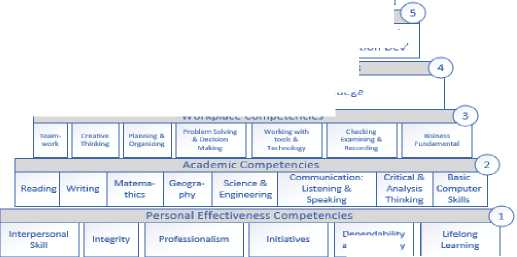
tncincerinc
Dependability end Reliability
Fig. 1. Pyramid of Geospatial Technology Competency Models [6, p 59]
The pyramid which describes the level of competence in the field of Geospatial technology more or less describes the same conditions as required by SKKNI (Indonesian National Work Competency Standards). The picture clearly shows the essential competency stages that must be possessed by geospatial technology HRs from the first level as technical personnel in the geospatial field up to the ninth or peak level, when the professional HR becomes the top management/ decision maker of the large work of geospatial information that provides IG services as a basis in development planning or business.
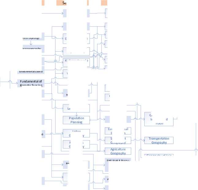
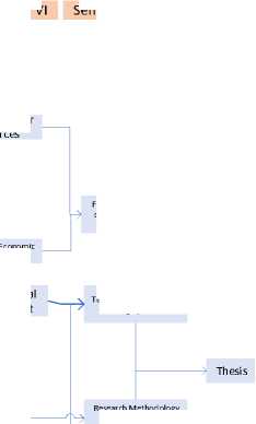
From the aspect of readiness of Indonesian tertiary institutions, preparing and responding to the needs of the following geospatial technology HR. It is presented in Fig. 2, as one of the study references, the tertiary curriculum for the field of geography, which in this study uses. The curriculum of the undergraduate study program in Geography and Environmental Sciences and undergraduate program of Cartography and Remote Sensing of Gajah Mada University (UGM) has been known as the standard of competence model in Geospatial HR in Indonesia[8].
UGM in developing aspects of academic competence of Geography and Environment of undergraduate students divide their knowledge into three groups. The first group is courses that provide a foundation of personal behaviour and mastery of basic science. This knowledge is given in the first year of lectures (semester I and II) which contains of 23 semester credit units (SCU). The second group is the mastery of expertise and interest development courses. These courses are delivered in semesters III, IV, and V. While the third group is the mastery of science and work ability courses. These competences are given in semesters VI and VII. The main objectives of these courses are to equip students with the ability to work. The learning process conducted through the block systems and problem based learning methods. Fig. 2 above presents visually in a graphic form the mechanism of creation of UGM Geography and Environment-undergraduates study program.
While for undergraduate study of Cartography and Remote Sensing, learning objectives prepared for students are formulated to produce quality graduates who are competent and qualified. It is expected that after students complete their undergraduate studies, they become mature human resources in mastering the fields of Cartography and Remote Sensing, and have a good personality[9]. In addition to UGM, the tertiary institution organizing the Geography Undergraduate Study Program is the University of Indonesia with four specializations, namely Physical Geography, Regional Planning, Geographic Information Systems (GIS), and Remote Sensing[10]. The two universities (UGM and UI) with Undergraduate Geography study programs are part of 41 universities in Indonesia that contribute to the availability of quality human resources in the field of geospatial technology. Where 39 other tertiary institutions are undergraduate program with Geography Education majors.
Physics
Persona lity Development and Basic Science
Expertise Science and Major Specific
Semester II
Semester III
Semester IV
Semester V
Soil Science
Geohydrology
Hydrometry
Tropical Climate
Population policy
Fundamental of Geomorphology
Geomorphological Survey and Mapping
Human Reosurce Development
Settlement Geography
Environmental degradation
Drainage Basin Hydrological System
Mineralogy Petrography
Watershed
Management
Environmental Economics
Economic Geography
Disaster Management
Soil Survey, Erosion and Conservation Planning
Geographic Information System II
Environmental Geomorphologic al
Tropical La ndsca pe Ecology
J Limnology
Population
Mobility 1
Socia l Planning
Semester I
General Geology
Hydrology
Human Geography
Introduction to Geography
Quality Зт
Water
Land and water Resources
Remote Sensing
Population Geography
I -----> Regional Science
Matemathics
Land Surveying
Practicum Chemistry
Chemistry
Religion Study
Statistics
Field Work I: Introduction to Landscape
Resources Geography
Field Work II: Process Measurement and Process Result of Geosphere
Urban
Geography
Regional Geograp hy of Indonesia
Geomorphology of indon esia and Southest Asia
Indonesia
Language
Enterpreneurship
Geogra phy of Asia Pacific
Fig. 2. Curriculum Undergraduate Study Program of Geography and Environmental Sciences [5], UGM undergraduate program of Geography and Environmental Sciences, 2016


Oceanography
Ecology and
Enviro nmental Scien ce
Hydrometeorolo gy
Geographic
Information System
La bour Study
Biogeography

Success Skill
Pancasila Education
Civic Education
Fundamental of Cartography
Fundamental of Social Science


Human and Economic Resources Analysis
Geographic of Industry and Trade
Expertise Science and Practical Ski ll
Semester VI
Field Work III: Analysis of Regional resources and Environmental
Techn iques and Analysis of G eograph ic Data
Semester VII Semester VIII
Environmenta management
Research Method ology of Environmental
Geography

Community Service
The factual data above illustrates how the roles and contributions are expected from universities in preparing reliable human resources in the field of geospatial information. This expectation is important and necessary in responding to the development of geospatial technology both for the needs of development planning and business planning.
Table 3. How Fit? First Level Building Competencies for individual effectiveness and University’s Curriculum, combination of [6,pp 59-60 with 8,p 3]
|
First Level |
University’ Curriculum |
|
Interpersonal skills |
V [first semester] |
|
Integrity |
V first, third semesters] |
|
Professionalism |
V [first semester] |
|
Initiative |
V [first semester] |
|
Dependability |
V [first semester] |
|
Lifelong Learning |
V first semester] |
The first level of the geospatial technology competency model (GTCM) begins with the individual mastery requirements on individual effectiveness competencies. Included in the first level is ownership of the personal attributes "soft skills" which are the basic capital for almost every role in life that is generally derived from home education and the influence of the neighbourhood which is then strengthened at school and at work. Table 3
shows, provides six building blocks of individual effectiveness competencies developed by GTCM DOLETA which compare with the UGM undergraduate curriculum.
Meanwhile, when talking about the second level of academic competence which is the field of developing HR knowledge competencies. This competency is obtained by his main human resources from tertiary institutions, he gets his knowledge and skills, and GTCM DOLETA provides eight building blocks of academic competencies as attached in the Table 4.
Table 4. How fit? Second Level Building Competencies for individual effectiveness and University’s Curriculum, combination of [6,pp 59-60 with 8,p 3]
|
Second Level |
University’ Curriculum |
|
Reading |
V [implicit] |
|
Writing |
V [implicit] |
|
Mathematics |
V [second semesters] |
|
Geography |
V [3rd up to 7th semesters] |
|
Science & Engineering |
V [3rd up to 7th semesters] |
|
Communication |
- |
|
Critical & Analytical Thinking |
V [implicit] |
|
Basic Computer Skills |
V [implicit] |
In terms of DOLETA's first and second competency levels, the initial evaluation of the roles and contributions of tertiary institutions based on aspects of the readiness of knowledge and skills carried out so far (curriculum, lecturers, educational facilities) shows that the basic competencies needed by HR are generally fulfilled.
However, at the third to eighth levels the role and contribution of higher education is expected to be greater. It is important for universities to develop a geospatial technology competency model that can be used as a reference for the SKKNI geospatial technology in Indonesia in accordance with new technological developments.
-
III. Proposed Solution: E-Learning And Distance Education
Realizing the deep gap between the needs of Geospatial professionals and the availability of human resources produced by Higher Education requires a quick solution. Indonesia has natural resource assets, has a demographic bonus, will have a higher economic opportunity if it is able to combine the two assets with the help of the availability of geospatial information.
Data and information show that the main obstacle to using the demographic bonus is that there are only 2 universities out of 41 universities that produce geography graduates who have geospatial information competencies. This condition requires a fast and appropriate solution.
A quick and appropriate solution is to develop education based on e-learning or distance education [11,12]. The advantages of this mechanism are first, being able to overcome the limitations of human resources (lecturers) and physical facilities such as classrooms. Students and graduates can be reproduced, with the condition that online materials are well available and the discussion mechanism can be done through the support of information technology (web and other information technology devices).
Second, it is proven that higher education can be done at a lower cost without having to reduce the quality of education [13, 14].
Third, distance education offers clear options and values to professionals who want to increase their knowledge and live far from universities [15].
Fourth, extraordinary efforts have been developed to produce best practices for online learning in the field of Geography. Empirical evidence from various studies provides confirmation that well-designed online courses provide the same results as conventional face-to-face lectures [16]. Even today, in some developed countries distance education in the field of geography covers a wider range of subjects and can be adjusted to the needs of skills of individuals or company [17, 18].
Fifth, the evidence shows that online courses in the field of GI-Science that was designed in the 1990s has now become a full program and can be completed at a distance [19-21].
Learning from experience in the US and proven success in several countries using e-learning in increasing the availability of HR GI-Science needs to be adopted for Indonesia [22, 23]. Adoption and development of online learning can begin with a number of subjects that are already well established [24,25].
-
IV. Discussions
As it is realized, geospatial information is a major and inevitable need for planning in various sectors both government and private in Indonesia. Factual data shows that 65% of government activities use spatial elements as the main identifier and 90% of government activities have spatial elements. The geospatial element is used as a core identifier to integrate various types of information (natural resource potential, disaster events, economic growth, agriculture, population, etc.). Geospatial information technology has been proven to be able to produce sharper and comprehensive analyses and offer faster and better problem solving from state and business problems.
An important and major part of the use of geospatial information as an analytical tool for planning is highly dependent on the availability of professional human resources. The fact that in terms of human resources there is a large gap between the needs and availability of labour in the field of geospatial technology is a problem that must be solved strategically by all stakeholders. The role of universities as a source of development of science and technology, and providers of quality human resources is a driving force for the solution to this problem.
From the aspect of scientific readiness (curriculum, lecturers, educational facilities) Indonesia's main tertiary institutions have the strength and ability to develop knowledge. The main task now is how to accelerate the availability process so that the narrowing of the gap between the needs and the availability of HR geospatial information.
There is no free lunch, one of an effort that can be done is through education technology development. It will be great challenge to fill the gap of Professional HR through online learning. It expected the online learning will also be upgrading the profession in the business who want to improve and upgrade their knowledge.
-
V. Conclusion
From the aspect of scientific readiness (curriculum, lecturers, educational facilities) Indonesia's main tertiary institutions have the strength and ability to develop knowledge. So that, first the main task of Universities recently is to take chance and accept a major role to fill-in the gap between need and availability of professional HR in geospatial information. The acceleration process can be done through provision of online learning and distance education.
Another important task that should be provided by tertiary institutions is that their readiness to be able to accommodate HR competencies in accordance with the level of competency needs of the geospatial technology labor market. In this context collaboration with Indonesia’s Standardization Board that issued SKKNI must seriously become one of the components used in preparing graduates to enter the geospatial technology labour market and make their best contribution.
Acknowledgment
References Indonesian Universities Readiness in Providing Professional HR in Geospatial Information
- Gusti Grehenson, Hubungan Masyarakat Universitas Gajahmada, (2016), Indonesia Kekurangan Tenaga Informasi Geospasial, https://ugm.ac.id/id/berita/12930-indonesia .kekurangan.tenaga.informasi.geospasial
- Estaville, L.E., (2010), Geospatial Workforce trends in the United States, International Journal of Applied Geospatial Research 1 (1), hal 57-66
- Siska Permata Sari, Okezone News, (2017), Ya Ampun! Indonesia kekurangan 20.000 lulusan Geospasial, Berminat? https://news.okezone.com/read/2017/08/24/65/1762017/ya-ampun-indonesia-kekurangan-20-000-lulusan-geospasial-berminat
- Rahmayulis Saleh, Kabar24, (2013), Indonesia Kekurangan SDM dan Tenaga Ahli, https://kabar24.bisnis.com/read/ 20130417/18/9078/indonesia-kekurangan-sdm-dan-tenaga-ahli
- Satria, Hubungan Masyarakat Universitas Gajahmada, (2017), Mengoptimalkan Teknologi Geospasial, https://ugm.ac.id/id/news/15200-mengoptimalkan. teknologi.geospasial
- David DiBiase et. al, (2010), The New Geospatial Technology Competency Model: Bringing Workforce Needs into Focus, URISA Journal, Vol.22, No.2, 2010, hal 55-72
- Ari Supriyanti, FER, (2017), BIG gandeng 18 PTN Dukung Pemetaan terstandar, https://www.beritasatu.com/ sains/419823-big-gandeng-18-ptn-dukung-pemetaan-terstandar.html
- Universitas Gajahmada,Departemen Geografi Lingkungan, (2016), Kurikulum-Departemen Geografi Lingkungan, https://gel.geo.ugm.ac.id/akademik/kurikulum/
- Universitas Gajahmada, Departemen Sains Informasi Geografi, (2017), Kurikulum- Prodi Kartografi dan Pengideraan Jauh, (2017), http://kpj.geo.ugm.ac.id/ kurikulum/
- Universitas Indonesia, Departemen Geografi FMIPA, (2014), Program Studi S1 Geografi, http://www.sci.ui.ac.id/ beta/wp-content/uploads/2014/03/ INFORMASI-PROGRAM-STUDI-S1-GEOGRAFI.pdf
- Clark, A.M., Monk, J. ,& Yool, S.R. (2007) GIS Pedagogy web-based learning and student achievement, Journal of Geography in Higher Education, 31,225-239
- [Terry, J. P., & Poole, B. (2012), Providing university education in Physical Geography across the South Pacific Island: Multi-modal course delivery and students grade performance, Journal of Geography in Higher Education, 36, 131-148
- Pappano, L. (2012) The year of the MOOC, The New York Times
- Caswell, T., Henson,S., Jensen, M., & Wiley, D (2008). Open content and open educational resources: Enabling universal education, The International Review of Research in Open and Distance Learning, 9, 1-11
- Solem, M., Chalmers, DiBiase, D., Donert, K., & Hardwick, S. (2006). Internationalizing professional Development in geography through distance education, Journal of Geography in Higher Education, 30, 147-160
- Means, B., Toyama, Y., Murphy, R, Bakia, M., & Jones, K. (2010), Evaluation of evidence-based practices in online learning: A meta-analysis and review of online learning studies, U.S Department of Education, Office of Planning, Evaluation, and Policy Development.
- Unwin, D. Tate, N., Foote, K., DiBiase, D (2011).Teaching Geographic Information Science and Technology in Higher Education, New York, NY: John Wiley & Sons.
- Garisson, D. R., & Kanuka, H. (2004) Blended learning: Uncovering its transformative potential in higher education, Internet and Higher Education, 7, 95-105
- McMaster, R.B., McMaster, S. A., Manson, S., Skaggs, R (2007), Professional GIS Education in the United States: Model of access and delivery, in XXIII international cartographic conference (pp. 1-13), Moscow: International Cartographic Association
- DiBiase, D., & Rademacher, H. J (2005),Scaling Up: Faculty workload, class size, and student satisfaction in a distance learning course on geographic information science, Journal of Geographic in Higher Education, 29, 139-158
- McAuley, A., Stewart, B., Siemens, G., & Cormier, D. (2010) Th MOOC model for digital practice, Retrieved from http://www.elearnspace.org/Articles/MOOC_Final.pdf
- Kemp, K., Reeve, D., & Heywood, D.I (1999). Interoperability for GIScience education. In A Vekoski, K. Brassel, , and H-J Schek Eds.), Interoperability of Geographic Information Systems (vol.1580, pp. 101-114), Berlin, Heidelberg, Springer.
- Garisson, D. (2011), e-learning in the 21st century: A framework for research and practice, New York, NY: Routledge.
- Schutzberg, A (2013), Professional Development MOOC on STEMx and geospatial technology coming this summer. In A. Schutzberg (Ed.), All Points Blog. Directions Magazine. Retrieved from http://apbdtectionsmag.com/entry/ professional-development-mooc-on-stem-and-geospatial-coming-this-summer/324359
- Anthony C. Robinson, Joseph Kerski, Erin C. Long, Heng Luo, David DiBiase & Angela Lee (2015) Maps and the Geospatial revolution: teaching a massive open online course (MOOC) in Geography, Journal of Geography in Higher Education, 39:1, 65-82, DOI:10.1080/03098265. 2014.996850
