Laser location and digital aerial survey as a subsatellite component in the system of information support of inventory, monitorin and cadastre of forest lands

Author: Danilin I.M., Danilin A.I., Svischev D.I.
Journal: Сибирский аэрокосмический журнал @vestnik-sibsau
Section: Математика, механика, информатика
Article in issue: 7 (33), 2010.
Free access
Approaches and solutions in the area of forest remote sensing methods for the purposes of information support of inventory, monitoring and cadastre of forest lands with the use of innovation methods and high-end technologies of laser location, digital aerial survey and global satellite positioning are considered in the paper.
Laser location, digital aerial survey, satellite positioning, inventory, monitoring and cadastre of forest lands
Short address: https://sciup.org/148176463
IDR: 148176463
Text of the scientific article Laser location and digital aerial survey as a subsatellite component in the system of information support of inventory, monitorin and cadastre of forest lands
In the contemporary practice of forest use, monitoring and cadastre to receive reliable and efficient information about state and dynamics of forest lands is an urgent problem concerning both natural resources and environment and nature protection.
Nowadays laser location and digital aerial survey, which are major constituents of geomatics – the newest integral direction in the development of remote sensing methods of the Earth (aerial- and space survey), geoinformation technologies, digital photogrammetry and cartography, satellite geopositioning and telecommunications are more and more widely used in the solution of this problem in many countries of the world as well as in Russia.
Those advanced and highly effective methods today find wide application in many branches of economy. In fact they are an information basis of natural resources cadastres, land- and forest planning, ecological monitoring, systems of data gathering, processing and analysis. Judging by their accuracy and economical efficiency they exceed other methods of studying and measuring parameters of the Earth cover and natural systems [1–7].
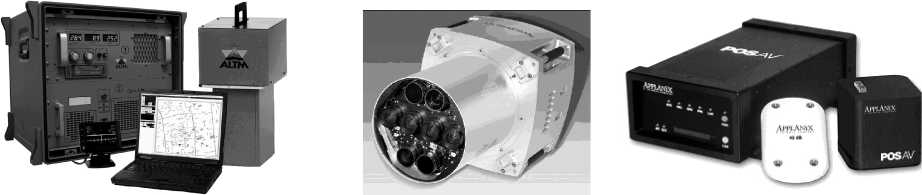
Modern high-end aviation laser location systems develop quickly and today they have a scanning frequency of more than 200 thousand pulses (measurements) per second (fig. 1).
The highest density of scanning pulses is 1 pulse per 5–7 cm of the surface, the accuracy of measuring geometric parameters of the ground objects and vegetation morphostructural elements in plan and profile projections is about ± (5–10) сm. The accuracy of satellite positioning of forest line contours and boundaries, sample plots, separate trees and morphostructural elements of their stems and crowns, including under crown space, is practically unlimited and is determined by technical parameters of the GPS instruments [1; 4].
a b c
Fig. 1. Instrument and technological components of a laser location method:
a – universal aerial surveying laser topographic system Optech ALTM 3100 supplies laser-location data (purpose: Digital Terrain Models, contours allocation, data decoding); b – large-format digital photogrammetric aerial camera Vexcel UltraCamXp supplies digital aerial photographs of ultrahigh (centimeter) resolution (purpose: traditional); c – system of direct geopositioning and orientation of aerial photography sensors Applanix POSAV supplies elements of external orientation of digital aerial photographs and laser-location data (purpose: direct geopositioning (geoaffixment))
Satellite snapshots got by modern optical-electronic systems such as Landsat, Resurs-DK, Ikonos, OrbView-3, WorldView-2, GeoEye-1 or other systems of high- and ultrahigh resolution and decoded by main parameters and characteristics of vegetation cover [5] may also be both the tools of spatial and detailed display of contours and relief of the Earth surface together with its vegetation and the base for preliminary routes tracing for laser and digital aerial survey.
Therewith the structure, volumetric trees and tree stands indices, their phytomass are determined more reliably and precisely by laser-location data (“laser portraits”), integrated with digital geotransformed aerial photographs on the basis of DTM and forest canopy distribution field, which are generated from the initial laser location data by filtering (separating) laser pulses, reflected from the Earth surface and vegetation, by means of the ground pulses interpolation with the following triangulation of pulses reflected from vegetation in systems of differential satellite positioning GPS, GLONASS [3; 5].
Mathematic morphology methods operating with the concept of set and fuzzy set theory [8] are used in processing and analyzing laser-location data and digital aerial photographs.
In some works implemented earlier in Russia and in other countries [1; 2; 5–7], it had been shown that accuracy of timber stock and forest biomass estimation, as well as by aviation sensing methods, can be increased up to 5–7 % with the use of morphological classification and allometric correlations among tree sizes.
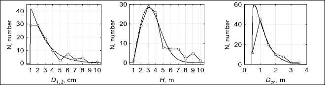
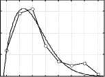
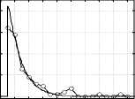
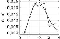
Our research conducted in Krasnoyarsk region shows that the structure of the Earth’s surface and vegetation cover elements with the use of DTM, generated by laser location and digital aerial photography are more adequately and effectively determined by characteristics of trees distribution lines according to the main morphometric indices – diameter and height, vertical and horizontal crown extent, which in their turn are closely intercorrelated. Therewith volumetric and weight trees and tree stands parameters are approximated with high accuracy by allometric functions through their morphometric indices (fig. 5, 6; table) [1].
a
b
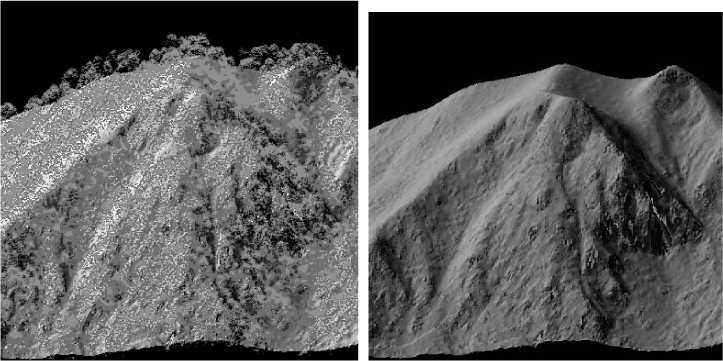
Fig. 2. Three-dimensional visualization of forest vegetation ( a ) and land relief in under crown space; ( b ) by laser-location data
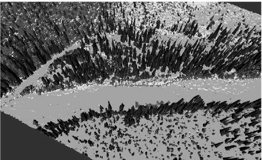
Fig. 3. Digital polygonal model of a larch stand, generated by laser-location data
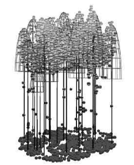
Fig. 4. Digital reconstruction of a larch stand morphological structure, implemented by laser location data
a
b
L cr. , m
Е
S cr. , m2
D cr. , m
d
f
Fig. 5. Distribution of larch trees ( N ) by morphometric indices of stems and crowns, approximated by Weibull function: a – D 1.3 is a tree stem diameter 1,3 m above its base, cm; b – H is a tree height, m; c – D cr is a crown diameter, m; d – L cr is a crown length, m; e – S cr is a crown area, m2; f – G is a sum of tree stems cross sectional areas 1.3 m above their bases, m2 ( G f ( D cr ))
Regression coefficients of morphometric indices and phytomass of larch trees
|
Model of approximation |
P = aD 2 1.3 H* |
P = aD 2 cr H |
||||
|
Parameters of the equation: |
a* |
S* |
R 2* |
a* |
S* |
R 2* |
|
Above ground part of a tree |
0.029 |
0.505 |
0.996 |
0.266 |
2.122 |
0.964 |
|
Stem |
0.0203 |
0.055 |
0.999 |
0.187 |
1.750 |
0.951 |
|
Timber |
0.017 |
0.037 |
0.999 |
0.153 |
1.452 |
0.950 |
|
Bark |
0.004 |
0.008 |
0.996 |
0.034 |
0.307 |
0.951 |
|
Crown |
0.008 |
0.258 |
0.976 |
0.079 |
0.427 |
0.983 |
|
Branches ∅ > 1 cm |
0.003 |
0.068 |
0.940 |
0.024 |
0.217 |
0.959 |
|
Branches ∅ < 1 cm |
0.002 |
0.021 |
0.969 |
0.020 |
0.272 |
0.892 |
|
Shoots of a current year |
0.0001 |
0.000 |
0.873 |
0.0001 |
0.005 |
0.966 |
|
Needle |
0.003 |
0.089 |
0.917 |
0.024 |
0.074 |
0.995 |
|
Dead branches |
0.001 |
0.002 |
0.987 |
0.009 |
0.110 |
0.918 |
* P is a weight of a tree fraction in absolutely dry state, kg; D 1.3 is a tree stem diameter 1.3 m above its base, cm; H is a tree height, m; Dcr is a crown diameter, m; a is a constant of the equation; S is a standard error of the equation; R 2 is an index of determination.
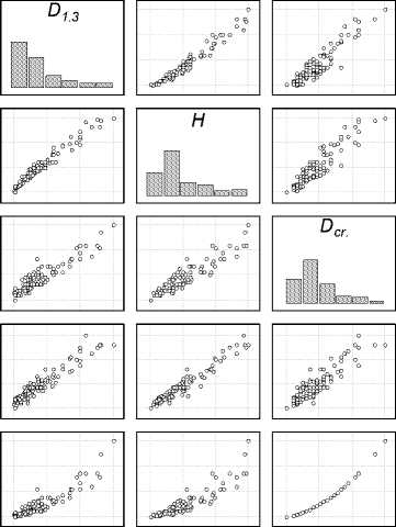
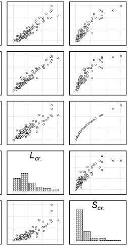
Fig. 6. An overlap matrix of distribution histograms and correlated scattering fields of the main morphometric indices of a larch tree stand (Central Evenkia)
It’s generally known, that the construction of trees distribution lines by their morphometric indices traditionally supposes completing time- and laborconsuming ground biometric procedures, measuring operations and trees recalculations (continuous or selective), which require substantial financial expenditures. At the same time laser location method integrated with digital high- and ultrahigh (centimeter) resolution aerial survey allows to perform pixel instrumental-measuring forest inventory on the basis of precision satellite geodesy and detailed topographic survey, to study forest cover dynamics, horizontal and vertical structure of tree stands, to reconstruct trees distribution lines by any morphometric indicator, and to calculate required forest inventory parameters and forest biomass automatically, with high accuracy and on sufficiently large areas (up to 500–600 square km per one working day).
Assessment of timber stock and forest phytomass by laser location and digital aerial survey data in every case is reduced to identification of basic regulations of an investigated object and to determination of correlations between tree stems volumes, tree and crown heights and diameters, and phytomass, which in their turn constitute 87–99 % of explained variability of different phytomass fractions – stems, crowns skeletons and needles [1].
The results of practical approbation of an aviation laser location method combined with digital aerial survey and satellite geopositioning, integrated into geoinformation systems, give us an evidence of its high potential in use for the purposes of forest cover and disturbance analysis and simulation, inventory, on-line ecological monitoring, information support of forest lands cadastre and forest use control. This highly effective method provides remote sensing evaluation of forest resources, their state and dynamics, with minimum field works and significant saving of time and financial resources.
Cost efficiency of this method is ensured by principal increase of accuracy of the measurement results and possibility of their repetition (verification), as well as by significant reduction of labour-intensiveness and work complexity ( of both field and laboratory kinds of work), at the expense of high level of automation in getting and processing laser location and digital aerial survey data. Thanks to this method the amount of field works is minimized and is necessary only for calibration of laser location results and support of aerial survey data interactive decoding.
