Method for assessment of long-term dynamics of NDVI on the territory of the Krasnoyarsk region using Modis/Terra satellite data

Author: Shevyrnogov Anatolii P., Pisman Tamara I., Ivanov Sergei A.
Journal: Журнал Сибирского федерального университета. Серия: Техника и технологии @technologies-sfu
Section: Информационно-коммуникационные технологии
Article in issue: 5 т.15, 2022.
Free access
This article is devoted to development of a method for assessing NDVI dynamics in northern territories and analysis of NDVI dynamics of vegetation on the territory of the Krasnoyarsk region using MODIS/Terra satellite data for the period (2000-2020). Spatial distribution map of average annual vegetation index NDVI has been made, indicating five latitudinal sections through the territory of the Krasnoyarsk region: the coordinates (latitude from 52˚ N to 76˚ N, longitude from 91˚ E to 95˚ E). Latitudinal variability of NDVI index for 20 years of measurements has been studied. Heterogeneity of long-term dynamics of vegetation has been discovered depending on the latitude of the studied territories. Efficiency of the suggested method for identifying long-term NDVI trends has been shown. A positive NDVI response of the vegetation cover of northern territories of the Krasnoyarsk region to climatic changes over the last 5 years has been revealed.
Algorithm, the krasnoyarsk region, vegetation, climate
Short address: https://sciup.org/146282505
IDR: 146282505 | UDC: 528.8.04, | DOI: 10.17516/1999-494X-0411
Метод оценки многолетней динамики NDVI на территории Красноярского края по спутниковым данным Modis/Terra
Работа посвящена разработке метода оценки динамики NDVI на северных территориях и анализу динамики NDVI растительности на территории Красноярского края по спутниковым данным MODIS/Terra за период (2000-2020 гг.). Построена карта пространственного распределения среднегодового вегетационного индекса NDVI с указанием пяти широтных разрезов через территорию Красноярского края: координаты (широта от 52˚ с.ш. до 76˚ с.ш., долгота от 91˚ в.д. до 95˚ в.д.). Исследована широтная изменчивость индекса NDVI за 20 лет измерений. Выявлена неоднородность многолетней динамики растительности в зависимости от широты исследуемых районов. Показана работоспособность предложенного метода для выявления многолетних трендов NDVI. Выявлен положительный отклик NDVI растительного покрова северных территорий Красноярского края на климатические изменения за последние 5 лет.
Text of the scientific article Method for assessment of long-term dynamics of NDVI on the territory of the Krasnoyarsk region using Modis/Terra satellite data
The problems of modern climate changes attract not only specialists’ attention – climatologists, but also those who are involved in planning economic development of such industries as energy, oil, coal and gas production. The recognized factors of climate change are: 1) an increase in atmospheric temperature due to an increase in concentration of carbon dioxide, methane and other greenhouse gases; 2) a decrease in temperature due to a significant increase in the content of atmospheric aerosol, for example, after volcanic eruptions; 3) “wavy” changes in air temperature near the Earth’s surface with slow fluctuations in temperature of the ocean surface; 4) changes in air temperature under the influence of fluctuations in solar activity [1].
Land cover and climate are indicators of natural ecosystems. The vegetation of landscapes, in turn, affects the climatic situation. Nevertheless, the climate is the primary factor, and its parameters and dynamics largely determine the type of vegetation in areas non-affected by intense anthropogenic impact [2].
Global warming strongly appears in northern latitudes of Russia. The temperature increase in cryolithozone of Russia is almost twice the global average. Atmospheric precipitation on the territory of Russia demonstrates changes in different directions depending on the region and season, with a predominance of increasing tendencies, especially in spring and autumn. Under the influence of continuing climatic changes, reduction of up to 10 % of the tundra vegetation area is possible [3].
Productivity, biomass and vegetation distribution boundaries change in accordance with dynamics of heat supply and moisture. The consequence of global warming may be a shift of the forest zone – 637 – boundary to the north [4]. It is also noted in literature that change in surface temperature during the peak of vegetation period influences on growth of vegetation productivity [5].
An increase in duration of frost-free autumn period contributes to the spread of species that have not been previously found in this area, which can change the spectral reflective characteristics of the surface [6].
In recent decades, there has been an increase in closeness of coniferous evergreen forests in Siberia, which is associated with climate change [7]. Along with this, moving of dark coniferous forests into the zone of larch dominance is observed [8], as well as into the ecotones of polar and alpine forest tundra [9].
It is noted that reduction of tundra and forest tundra area may lead to a decrease in albedo (reflectivity) of northern territories. This, in turn, will cause additional warming in this region. Assessment of vegetation response to changes in climatic conditions according to satellite data shows that an increase in the vegetation index in tundra may be accompanied by multidirectional albedo trends in neighboring areas [2].
In this article, changes in landscape zones in the Krasnoyarsk region happened as a result of global warming over the period (2000–2020) are assessed using long-term MODIS/Terra (NDVI) satellite data. The regions of the north of the Krasnoyarsk Territory with maximum changes in the spectral characteristics of the surface are distinguished.
Materials and methods
The territory of the Krasnoyarsk region from 91˚ E to 95˚ E and from 52˚ N to 76˚ N has been chosen as the object of the research. The choice of such an object is due to the fact that there are a variety of biological and climatic zones on the territory of the Krasnoyarsk region due to its large latitudinal length of about 3000 km. Remote sensing of the Krasnoyarsk region makes it possible to study various climatic zones – arctic, subarctic, temperate.
MODIS/Terra data (MOD 13C 2 product) for the period (2000–2020) have been used as the source material. MOD 13C 2 represents monthly vegetation indices obtained using a spectroradiometer. The NDVI index (Normalized Difference Vegetation Index) is used as the vegetation index under study – the normalized differential vegetation index is a simple quantitative indicator of photosynthetically active biomass. It is calculated by the following formula:
NIR - RED
NDV1 =--------
NIR +RED where NIR is reflection in the near infrared region of the spectrum, RED – reflection in the red region of the spectrum.
Global data of MOD 13C 2 product are cloudless spatial composites and are provided as a Level 3 product projected onto the geographical grid of climate modeling (CMG) – 0.05 degrees (5600 m). The MOD 13C 2 product has data fields for NDVI, EVI, VI QA, albedo data, angular information and spatial statistics, including averages, standard deviations and the number of input pixels used with a resolution of CMG 0.05 degrees. In this study, the vegetation index NDVI is used to study objects similar to steppe vegetation, tundra and forest tundra. The vegetation map is used to verify received remote data ( http://mir-map.ru/map440177_0_0.htm ).
Results and discussion
Information from five sections is used to study the latitudinal variability of NDVI on the territory of the Krasnoyarsk region: the coordinates (latitude from 52˚ N to 76˚ N, longitude from 91˚ E to 95˚ E) (Fig. 1).
Figure 2 shows the result of latitudinal dynamics of NDVI index of only one section (the most significant) in longitude 91˚E. Changes in NDVI index in the section of the territory of the Krasnoyarsk region are presented for the years 2015 and 2020.
By analyzing this figure, a significant difference has been noted in the NDVI values for the years 2015 and 2020 at latitudes from 70 ° N to 76 °N. These changes amount to 30–40 %, that is, from 2015 to 2020, there was a strong response of vegetation to global temperature variability in northern latitudes. At more southern latitudes (from 70 °N and below), such changes are not explicitly distinguished.
Fig. 2 clearly shows the areas corresponding to different types of vegetation. From 76 °N to 70˚ N you can observe the Arctic desert zone (according to the source: http://dendrology.ru/forest/item/ f00/s00/e0000159/index.shtml). From 70˚ N to 58 ° N, an increase in the NDVI value is noted, which corresponds to the transition from tundra to forest tundra, then to boreal forests, where coniferous woodlands begin. Moving south, density of coniferous forests increases, then mixed forests are observed. From 58 ° N to 54 °N there is a drop in NDVI, which corresponds to the transition to mountain taiga vegetation. Then comes a sharp increase by 53 ° N, which corresponds to dark coniferous mountain forests. Then there is a decrease in NDVI, which indicates the presence of mountain steppes.
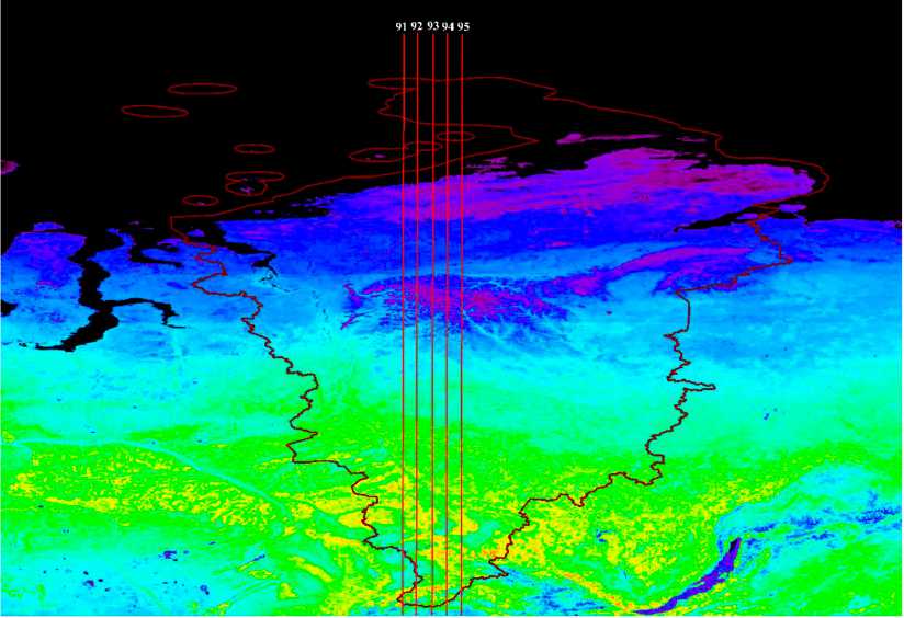
Fig. 1. Map of the spatial distribution of average annual vegetation index NDVI for the period 2000-2020, indicating five latitudinal sections through the territory of the Krasnoyarsk region: the coordinates (latitude from 52 ° N to 76 °N, longitude from 91˚ E. to 95 °E).
Figure 3 shows long-term dynamics (2000–2020) of the averaged NDVI value on the territory of the Krasnoyarsk region above 70˚ N. It can be seen from the graph that since 2000, during the first three years, there had been an increase in NDVI by about 30 %. In recent years (from 2019 to 2020), the value of the NDVI index grew by 35 % compared to the previous year.
These results are confirmed by other authors. It is shown that transitional natural zones are an open system for the impact of climate changes and react quickly enough to climatic fluctuations. This is especially typical for northern landscapes [10]. The predominant shift of the border of closed evergreen coniferous stands in Siberia in the northern direction has been revealed. The increase in the area of evergreen coniferous stands (by 15–50 %) contributed to the expansion of their boundaries and was heterogeneous depending on the relief [11].
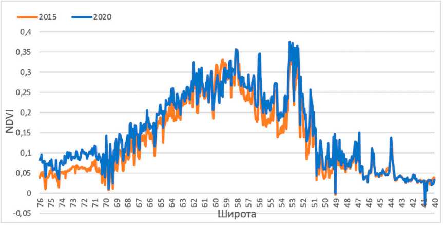
Fig. 2. Dynamics of NDVI vegetation index in the context of the territory of the Krasnoyarsk region for the years 2015 and 2020 by longitude 91 °E.
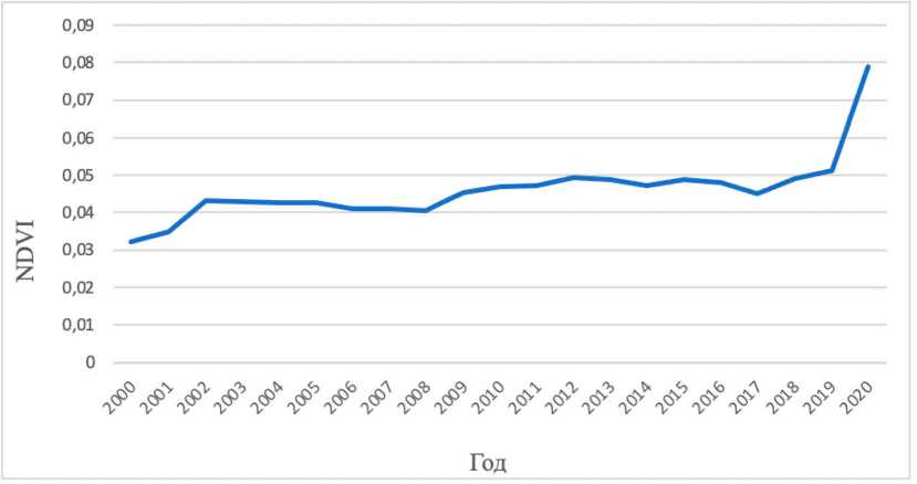
Fig. 3. Average NDVI value for the period (2000–2020): the coordinates (latitude from 70˚ N to 76 ° N, longitude from 91 °E to 95 ° E).
Conclusion
In this paper, based on long–term (2000–2020) MODIS/Terra (NDVI) satellite data, possible changes in landscape zones on the territory of the Krasnoyarsk region happened as a result of global warming are being assessed. As a result, the following conclusions have been made:
-
– latitudinal sections of long-term dynamics of NDVI index on the territory of the Krasnoyarsk region have been obtained: the coordinates (latitude from 70 ° N to 76 ° N, longitude from 91 ° E to 95 ° E).
-
– sensitivity of the vegetation cover of northern territories of the Krasnoyarsk region to climate change, in particular, to an increase in atmospheric temperature, is shown;
-
– the regions of the north of the Krasnoyarsk region with maximum changes in the spectral characteristics of the surface have been identified;
-
– the response of the vegetation cover of northern territories of the Krasnoyarsk region to climatic changes over the last 5 years has been revealed.
References Method for assessment of long-term dynamics of NDVI on the territory of the Krasnoyarsk region using Modis/Terra satellite data
- Покровский О. М. Анализ факторов изменения климата по данным дистанционных и контактных измерений. Исследование Земли из космоса, 2010, 5, 11-24 [Pokrovsky O. M. Analysis of climate change factors based on remote and contact measurements Exploring the Earth from Space, 2010, 5, 11-24 (in Russian)]
- Титкова Т. Б., Виноградова В. В. Изменения климата в переходных природных зонах севера России и их проявление в спектральных характеристиках ландшафтов. Современные проблемы дистанционного зондирования Земли из космоса, 2019, 16(5), 310-323. (DOI: 10.21046/2070-7401-2019-16-5-310-323) [Titkova T. B., Vinogradova V. V. Climate changes in the transitional natural zones of the North of Russia and their manifestation in spectral characteristics of landscapes. Modern problems of Remote sensing of the Earth from Space, 2019, 16(5), 310-323. (DOI: 10.21046/2070-7401-2019-16-5-310-323) (in Russian)]
- Myers-Smith I., Hik D. S. Climate warming as a driver of tundra shrubline advance. J. Ecology, 2018, 106(2), P. 547-560
- Karger D. N., Kessler M., Conrad O., Weigelt P., Kreft H., Kinig C., Zimmermann N. E. Why tree lines are lower on islands - Climatic and biogeographic effects hold the answer. Global Ecology andBiogeography, 2018, 1-12. (DOI: 10.1111/geb.12897)
- Yu Q., Epstein H., Engstrom R., Walker D. Circumpolar arctic tundra biomass and productivity dynamics in response to projected climate change and herbivory. Global Change Biology, 2017, 23, 3895-3907. (DOI: 10.1111/gcb.13632)
- Кокорин А. О., Добрынин Д. В., Сухова О. В. Для понимания климатической динамики и адаптации системы охраны природы требуются детальные данные и прогнозы. Арктические ведомости, 2018, 2(25), 96-105 [Kokorin A. O., Dobrynin D. V., Sukhova O. V. Detailed data and forecasts are required to understand climatic dynamics and adaptation of the nature protection system. The Arctic Herald, 2018, 2(25), 96-105 (in Russian)]
- He Y., Huang J., Shugart H. H., Guan X. Unexpected evergreen expansion in the Siberian forest under warming hiatus. J. Climate, 2017, 30(13), 5021-5039
- Kharuk V. I., Ranson K. J., Dvinskaya M. L., Evidence of evergreen conifer invasion into larch dominated forests during recent decades in central Siberia. Eurasian J. Forest Research, 2007, 10, 163-171
- Mamet S. D., Brown C. D., Trant A. J., Laroque C. P. Shifting global Larix distributions: Northern expansion and southern retraction as species respond to changing climate. J. Biogeography, 2019, 46(1), 30-44
- Bhatt U. S., Walker D. A., Raynolds M. K., Bieniek P. A., Epstein H. E., Comiso J. C., Pinzon J. E., Tucker C. J., Steele M., Ermold W., Zhang J. Changing seasonality of panarctic tundra vegetation in relationship to climatic variables. Environ. Res. Lett., 2017, 12, 055003. (doi.org/10.1088/1748-9326/ aa6b0b)
- Им С. Т., Харук В. И., Ли В. Г. Миграция северной границы вечнозелёных хвойных древостоев в Сибири в XXI столетии. Современные проблемы дистанционного зондирования Земли из космоса. 2020, 17(1), 176-187. DOI: 10.21046/2070-7401-2020-17-1-176-187 [Im S. Т., Kharuk V. I., Lee V. G. Migration of the northern border of evergreen coniferous stands in Siberia in the XXI century. Modern problems of Remote sensing of the Earth from Space. 2020, 17(1), 176-187. DOI: 10.21046/2070-7401-2020-17-1-176-187 (in Russian)]
