Methodology for defining pivotal settlements in the Russian Arctic

Author: Fauzer Viktor V., Smirnov Andrei V., Lytkina Tatyana S., Fauzer Galina N.
Journal: Economic and Social Changes: Facts, Trends, Forecast @volnc-esc-en
Section: Spatial aspects of territorial development
Article in issue: 5 (65) т.12, 2019.
Free access
Settlement in new regions of the Russian North, available for new economic exploitation, started at the beginning of the 20th century: the exploration of mineral deposits, its mining and shipment into southern regions commenced at the same time. Experience of building cities as trade and industrial centers, marine ports, and military settlements, which was acquired in the 18th-19th centuries, was insufficient. It was necessary to define forms of settlement, quantitative parameters of emerging communities, and convenience of the latter. Discussions and knowledge acquisition resulted in a consent to build permanently populated large cities. It was suggested to build basic cities in the North and pivotal cities, which would have infrastructural functions, in nearby areas. Quantitative guidelines on population numbers for each type of settlement were proposed: pivotal cities - 300 thousand residents, basic cities - 80-150 thousand people, industrial cities - 15-30 thousand inhabitants, watch and expeditionary villages- 3-5 thousand people. After making the Arctic Zone in the Russian North the independent management unit consisting of nine pivotal areas, it became necessary to justify settlement framework, which would meet new requirements. Thus, the purpose of this article is to develop the methodology of calculating the Index of Pivotal Settlement which would allow us to classify an urban settlement as a multifunctional pivotal settlement, a pivotal settlement, a potential pivotal settlement, and as a settlement which does not meet criteria of a pivotal one. The creation of this index is based on three methodological principles: complexity, consistency, and account of agglomeration effect. The calculation of the index of the Arctic pivotal settlements is carried out due to the concept of demographic gravitation. Acquired results would allow each Arctic pivotal area to determine pivotal settlements, and the centers of surrounding areas development.
Arctic, population, settlement, pivotal areas, pivotal and basic cities
Short address: https://sciup.org/147224218
IDR: 147224218 | UDC: 338.2 | DOI: 10.15838/esc.2019.5.65.2
Text of the scientific article Methodology for defining pivotal settlements in the Russian Arctic
It is difficult to overestimate the role of the Arctic in country’s economic development. 90.4% of the whole Russia’s natural gas amount was mined here, as well as 24.7% of associated gas, 17.6% of oil, and 10.8% of iron ore concentrate. Also, more than 50% of platinum, nickel, cobalt, copper, 15.0% of fish and fishery products were produced here1.
The formation of the settlement system in Northern and Arctic regions was conducted in several steps. The period of the 1930s was experimental in terms of building cities and urban-typed settlements (UTS). The 1940s could be characterized by rapid increase in the North economic development rates. In the following years, together with industrial and urban development, a broad geological search was continuing and new, unique deposits were discovered. The settlement of the Far North regions in 1970s was influenced by science and technology development.
The focal settlement structure, which has a pattern of territorial expansion on the basis of socio-economic relations between industrial centers and economically developed areas of the middle zone, is the characteristic of the early North exploration period [1, p. 1720]. Due to unfavorable natural and climatic conditions, and high expenditures on all sorts of manufacturing works, social infrastructure, and personnel maintenance, continuous territorial Arctic development has never happened. Besides, it is prohibited because of the environmental reasons. Thus, the focal settlement type, which is based on large strategic mineral deposits, is and will be the only option for the Arctic [2, p. 31].
V.I. Kondrat’eva notes that “space characteristics typical of the Russian region of the Arctic, such as focal-dispersed settlement nature, underdevelopment of road and transport infrastructure, extremely high costs of life support, due to extreme climatic conditions, show the advantage of this territorial approach, which purpose is the resource investment into pivotal settlement and infrastructural frameworks’ development” [3, p. 6].
The model of pivotal settlements based on the concept of demographic gravitation is presented in this paper. Pivotal network should contribute to Russia’s economic development and comfortable life of population in the Russian region of the Arctic. Special attention is given to the study of the longtime practice of building settlements for the permanent population residence. It is is different from foreign practice which is based on the building of temporary settlements.
In 2010s, approaches toward the Russian North development went through significant changes: attention was shifted to the Arctic space rather than the exploration of all Northern territories. Out of 11,931,100 sq. km of the Russian North, 3,754,600 sq. km (31.5%), which make up AZRF (Arctic Zone of the Russian Federation) land territories, were given special attention. 2,406,400 mil. people, or 24.3% (out of 9,920,920 mil. northerners) became residents of the Arctic.
Nowadays, most northern strategies and development programs are aimed at the Arctic2. Authorities’ attitude toward northern territories also changed. The former strategy “from exploration to habitation” has transformed into “the transition from the residence policy to the policy of non-indigenous population staying in the Far North” approach. It makes studies on the watch-based method of labor organization, on the network of pivotal settlements justification, and centers of arctic space development relevant.
The research on settlement network transformation from small villages to pivotal and basic cities was analyzed within the methodology of “spatial development”, which can be defined as coordinated progressive changes in the development and reproduction of natural resources, the placement and internal maintenance of productive powers, in the population settlement, and the construction of the living environment [4, p. 97; 5, pp. 22-25].
The subject of the research is the Russian region of the Arctic within borders defined by the President of the Russian Federation in his Decree 2873 dated 27.06.2017. In 2019, eight uluses of Sakha Republic (Yakutia), which are not analyzed in the article4, were included into AZRF. The goal of the research is to develop a methodology for calculating the Index of Pivotal Settlement which would allow relating an urban settlement: to a multifunctional pivotal settlement, to a pivotal settlement, to a potential pivotal settlement, to a settlement which does not meet criteria of a pivotal one. The following goals were set: to analyze the transformation of the settlement system in the Russian region of the Arctic, to examine the modern approaches to the settlement of the Russian North, to analyze the dynamics of population and urban settlements in the Russian region of the Arctic, to develop a method and algorithm of calculating the pivotal settlements index, and to arrange urban settlements in the Russian region of the Arctic according to criteria of pivotal settlements.
The informational basis of the study is represented by the Russian Federal State Statistics Service data, which include a database of municipalities’ indicators, official websites of cities and villages, websites of authorities and state organizations, databases of geographical data, regional and federal legal acts.
Transformation of the settlement system: from small villages to pivotal and basic cities
At the early stage of the Russian North industrial development, manufacturing villages were built near employment places according to “the house within walking distance from work” principle. It was especially popular in the Far North. This practice caused emergence of separate, small, sometimes temporary, inconvenient settlements which were not connected to each other in a functional and planning way. Population in these cases included three thousand people, which led to increased urban development costs due to low building density. With the development of deposits, a significant part of the settlements were liquidated [6, p. 159]. The major problem consisted in the fact that it was impossible to create environment for meeting human needs in this region. Later, the existing settlement network was improving through gradual “involvement” of separated small villages in the process of urbanization [7, pp. 241-245]. Another problem – there is always a chance of early necrosis of the city in the North. So, after the depletion of deposits, the choice appears: to leave the settlement or artificially prolong its life by building new city-forming objects [1, p. 61]. This problem is valid for the town of Inta in the Komi Republic. The last (out of 5 mines producing more than 5 million tons of coal) mine was closed in February of 2019. Thus, people of Inta do not know where they can find a job. The authorities of the Komi Republic do not address the issue of people’s occupation.
During this time-period, the mainstream point of view was that relatively large cities should play the prominent role in newly developed Northern regions. The reason lies in the fact that it is possible to organize more cultural activities, to support people’s spiritual enrichment through their contacts with other people, and to intensify scientific work in these types of cities. They also can be the centers of highly developed settlement systems: it is impossible to imagine the further construction of new and development of existing cities without them [1, p. 24].
According to V.V. Pokshishevskii, “urbanists express their idea about optimal Russian city with a population around 50-300 thousand people, in some cases, more precise – 150 thousand people” [8, p. 102]. V.K. Sveshnikov gives quantitative criteria “to certain types of cities: pivotal – 300 thousand people, basic – 80-150 thousand, industrial – 15-30 thousand, watch and expedition villages [9, p. 11].
The main types of urban Northern settlements appeared: pivotal (situated outside the North zone), basic cities (TPC centers and industrial units), and UTS (industrial, transport, organizational and economic).
Pivotal cities (population over 200 thousand people) – bases of development of adjacent Northern territories. They include enterprises of the construction, repair, light industry enterprises, as well as institutions of logistics. If possible, they will also develop a network of universities, research and design organizations, service complexes taking into account the development of mobile forms of service deliveries to the Northern regions [7, pp. 241245].
A pivotal city is usually situated in good natural and climatic environment in the southern or the central part of the Far North. It is a major center of an industrial, or administrative, region, which is the center of a highly organized settlement system and the pivotal base for the development of the North [1, p. 81].
Basic cities (50–100 thousand people) will include head enterprises of the corresponding TPC and the complex of maintenance industries. They should include the bulk of the population of the respective settlement systems within the optimal radius of accessibility, so the role of these cities as transport and distribution centers is important. In cases, when the basic city becomes home for shift staff and their families, it should have additional housing and cultural institutions. At the same time, according to the calculations of CSRDI city building, the cost of basic cities urban construction increases by 5–10%.
Industrial, transport, or administrative settlements (3–5 thousand inhabitants) are additional centers of development of the most remote northern areas. They are very important for initial stages of development [7, pp. 241245].
Currently, it is possible to come across a different definition of a pivotal city. For example, O.P. Kuznetsova and E.A. Yumaev characterize a pivotal city as a basic one. They say that “shift camps employees and their families live in pivotal cities according to expeditionary settlement system. Nowadays, pivotal settlements of the Arctic Zone are simultaneously considered centers of industrial and cultural Arctic development and pivotal bases of exploration of sparsely populated Arctic territories. Pivotal cities are seen as links in the technology distribution chain, increasing the diffusion of innovation speed [10, p. 117].
Thus, in the 1970s–1980s, it was proposed to regard pivotal those cities which have population around 200–300 thousand people, situated outside the North area, and basic – Northern cities with population from 50 to 150 thousand people. After studying settlement problems in the Global Arctic [11, pp. 44-46; 12, pp. 10-14], the history of urban settlements in the Russian Arctic from the 14th to 21st century, we came to the conclusion that the most part of arctic cities must have the limits of growth: their optimal population number is 50–100 thousand people [13, p. 127]. However, at the same time, Arkhangelsk, Murmansk, Norilsk and a number of other large settlements will successfully continue their development.
Modern approaches to the settlement system of the Russian North
Major attention in the 20th–21st century was given to the settlement system. the country’s defense, economic efficiency, comfort of life, and mobility of the population depended on its science-based organization.
New Russia still operates on the basis of its old territorial framework: its formation took a long time and the most active period of its developing was in the 20th century, within soviet model [14, p. 67]. At the end of the 20th century, the basic settlement principles were laid down in the prolonged “General settlement scheme on the territory of the Russian Federation”. It is noted in this document that, in Russian environment, cities with population around 100 thousand people are ready for performing functions of pivotal interregional settlement centers. However, certain cities with lesser population could still be pivotal centers. Such cities should have an advantageous transport position, favorable background for locating industrial facilities, MTS organizations, and construction bases, appropriate conditions for the business activity development.
It was stated in the document that “formation of permanent settlements in northern areas with unfavorable medical and geographic conditions is not advisable”. Sub-zone of the Near North, which has more favorable conditions for living and economic activities, is proposed for placing enterprises of “northern raw materials” processing on it and developing large urban settlements – basic centers for people, who maintain Far North objects by shift methods.
Improvement of urban and rural settlements network requires consideration of zonal and sectoral features of the North, areas of existing settlements, and traditional economic activities of indigenous people. It involves: the transition from the residence policy to the policy of non-indigenous population staying in this region, especially in the conditions of the Far North; deepening labor division between Northern regions and the regions which contain developing pivotal centers of the North exploration .
The authors of the settlement scheme for Northern regions recommend “to limit the growth of cities as much as possible; to ensure a strict selection of people arriving in the Northern regions according to professional and health criteria; to organize gradual transition to the implementation of the planned employees’ shift”. It is necessary to put people in promising settlements with a stable socio-economic base, to avoid creation of new small settlements, and more actively introduce a shift method of labor organization. Close attention should be paid to the revival of the northern indigenous people’s national settlements, and the preservation of their traditional way of living. We will have to overcome the increasing stagnation of small and medium-sized urban settlements, which determine the economic and social life of surrounding rural areas5.
Also, there are documents for different regions. Thus, according to “Socio- economic development of the Far East and Baikal Region until 2025”, adopted by the RF Government Resolution no. 2094-р, dated 28.12.2009, the goals of national policy in the Far Eastern Federal District are:
– to form a sustainable settlement system based on regional zones of advanced economic growth with human-favorable environment;
– to form population and labor resources sufficient for the solution of regional economic problems, and the improvement of human capital quality;
– to preserve and support traditional life of the Russian indigenous minorities6.
Further elaboration of the settlement system is given in the “Strategy of socio-economic development of Siberia until 2020”, which contains the development priorities: the formation of large urban agglomerations; the construction of energy saving houses for agricultural and shift employees; the construction of pivotal settlement structure, which provides professionally trained regular and shift employees for agro-industrial and mining complexes; the formation of the perspective planning framework of the settlement system and the preservation of prioritized natural management areas for northern indigenous people.
It is proposed to switch to a fundamentally new technology of infrastructural development and territorial settlement. It is noted that the prevailing forms of “spatial settlement system organization will be: urban and rural settlements as the system-building elements of the economic, cultural territorial development and the provision of necessary social services to indigenous people of the North; local settlement systems, functioning on a rotational basis, in the areas of new exploitation”7.
At the same time, it is necessary to take into account that projects’ implementation in the Arctic requires support of all existing basic circumpolar cities, which are suppliers of rotational employees maintaining major arctic projects [15, p. 27].
Population and urban settlements in the Russian region of the Arctic
At the beginning of 2018, population of the Arctic lived in 58 urban regions and municipal districts, which included 39 cities, 40 towns, and 150 rural settlements. Until 1989, the number of urban settlements grew steadily and reached a peak of 125 settlements. By 2018, the number had decreased to 82; the drop of UTS-numbers is especially noticeable – from 93 to 43 units. At the same time, the average and median population of urban settlements has been growing over the years, reaching 27.2 and 8.3 thousand people respectively in 2018.
Nowadays, many people hope that the Russian region of the Arctic will increase Russia’s economic potential at the expense of its natural-raw resources. However, the demographic dynamics shows some problems.
Table 1. Distribution of urban settlements of the Russian region of the Arctic according to the population number, 1939–2018
|
Indicator |
1939 |
1959 |
1970 |
1979 |
1989 |
2002 |
2010 |
2018 |
|
AZRF population, thousand population, |
980.8 |
1671.2 |
2209.4 |
2690.6 |
3420.2 |
2707.0 |
2480.6 |
2406.4 |
|
including urban |
677.1 |
1414.6 |
1885.7 |
2325.8 |
3020.3 |
2395.9 |
2207.1 |
2147.7 |
|
rural |
303.7 |
256.6 |
323.7 |
364.8 |
399.9 |
311.1 |
273.5 |
258.7 |
|
Number of urban settlements, including: |
29 |
95 |
106 |
115 |
125 |
106 |
85 |
82 |
|
cities |
13 |
19 |
25 |
28 |
32 |
40 |
39* |
39 |
|
UTS Distribution of urban settlements according to population, thousand people: |
16 |
76 |
81 |
87 |
93 |
66** |
46*** |
43*** |
|
more than 100 |
2 |
3 |
4 |
5 |
5 |
4 |
6 |
6 |
|
50-100 |
0 |
2 |
1 |
3 |
9 |
7 |
3 |
3 |
|
20-50 |
5 |
7 |
12 |
15 |
14 |
13 |
14 |
13 |
|
10-20 |
6 |
15 |
14 |
15 |
19 |
18 |
16 |
13 |
|
5-10 |
6 |
15 |
19 |
16 |
22 |
15 |
13 |
11 |
|
less than 5 Population-size indicators of urban settlements, people: |
10 |
53 |
56 |
61 |
56 |
47** |
33*** |
36*** |
|
average |
23,349 |
14,890 |
17,790 |
20,224 |
24,163 |
23,038 |
26,915 |
27,186 |
|
median |
8,385 |
4,392 |
4,543 |
4,812 |
5,478 |
5,943 |
8,555 |
8,252 |
|
standard deviation |
54,556 |
36,787 |
48,222 |
55,763 |
62,677 |
54,022 |
58,441 |
58,660 |
|
* in 2004, Talnakh and Kayerkan became a part of Norilsk, Tarko-Sale was non-populated. |
formed; ** including two non-populated; *** including three |
|||||||
7 RF Government Decree no. 1120-р “On Approval of the Strategy of Social and Economic Development of Siberia till 2020”, dated 5.07.2010. Available at: https://
Peak population numbers were in 1989 – 3.4 million people, in 2018 the number was 2.4 million. Total loss of Arctic population is 1.0 million people (29.6%). The fastest rate of population decrease was noticed among rural people: in correspondence with 2018 numbers, 71.1% of people stayed in urban areas, while 64.7% of people remained in rural regions. According to the number of habitants criteria, there are 36 (43.9%) settlements with less than 5 thousand people (Tab.1) .
According to the number of population, all settlements are divided into small (less than 50 thousand), middle-sized (50–100), large (100– 250), and major cities (more than 250 thousand people). We are interested in cities with population over 50 thousand people. There are not many of them: in different years, their number did not exceed 14. In 2018, 9 cities met these criteria, 4 of them became small cities, and Talnakh became a part of Norilsk.
There are two major cities in the Russian North: Arkhangelsk and Murmansk; 645.1 thousand people live there, or 30% of the whole urban population. Four cities are the large ones: Severodvinsk, Norilsk, Novy Urengoy, and Noyabrsk. Their population is 584.6 thousand people (27.2%). Middle-sized cities are Vorkuta, Apatity, and Severomorsk – 166.5 thousand people (7.8%). Four small cities: Nadym, Monchegorsk, Novodvinsk, and Kandalaksha – 156.4 thousand people (7.3%). Since 1989, Novy Urengoy has had a positive population growth, and since 2010 – Arkhangelsk and Norilsk too (Tab. 2).
An important socio-economic characteristic of the settlement system is the uniformity of population settlement and distribution of the economy. The area of the Russian region of the Arctic is 3.8 million square km, or 21.9% of the country’s territory.
The area of 24 UD, where 75% of the Arctic zone population lives, only occupies 0.7% of Arctic total area. The Arctic economy is also located unevenly. More than a half (58.2%) of the shipped goods, performed works and services accounts for 3.5% of the area. Almost a quarter (24.3%) of arctic economy is concentrated in Purovsky District of Yamalo-Nenets Autonomous Okrug. About 0.5% of
Table 2. Russian cities in the Arctic with population over 50 thousand people, 1939–2018
|
City |
Year of establishment |
Year |
|||||||
|
1939 |
1959 |
1970 |
1979 |
1989 |
2002 |
2010 |
2018 |
||
|
1. Arkhangelsk |
1584 |
251.0 |
256.3 |
342.6 |
385.0 |
415.9 |
356.1 |
348.8 |
349.7 |
|
2. Murmansk |
1916 |
119.4 |
221.9 |
308.6 |
380.8 |
468.0 |
336.1 |
307.3 |
295.4 |
|
3. Severodvinsk |
1938 |
21.3 |
78.7 |
144.7 |
197.2 |
248.7 |
201.6 |
192.4 |
183.3 |
|
4. Norilsk |
1953 |
– |
109.4 |
135.5 |
180.4 |
174.7 |
134.8 |
175.4 |
179.6 |
|
5. Novy Urengoy |
1980 |
– |
– |
– |
– |
93.2 |
94.5 |
104.1 |
114.8 |
|
6. Noyabrsk |
1982 |
– |
– |
– |
– |
85.9 |
96.4 |
110.6 |
106.9 |
|
7. Vorkuta |
1943 |
– |
55.7 |
89.7 |
100.2 |
115.6 |
84.9 |
70.6 |
58.1 |
|
8. Apatity |
1966 |
– |
– |
45.6 |
62.0 |
88.0 |
64.4 |
59.7 |
56.1 |
|
9. Severomorsk |
1951 |
– |
28.1 |
40.9 |
50.1 |
62.1 |
55.1 |
50.1 |
52.3 |
|
10. Nadym |
1972 |
– |
– |
– |
26.1 |
52.6 |
45.9 |
46.6 |
44.6 |
|
11. Monchegorsk |
1937 |
28.5 |
45.5 |
46.0 |
51.4 |
68.7 |
52.2 |
45.4 |
42.1 |
|
12. Novodvinsk |
1977 |
– |
– |
– |
47.8 |
50.2 |
43.4 |
40.6 |
38.4 |
|
13. Kandalaksha |
1938 |
22.2 |
38.2 |
42.7 |
45.4 |
54.1 |
40.6 |
35.7 |
31.3 |
|
14. Talnakh |
1982 |
– |
– |
– |
– |
62.8 |
58.7 |
–* |
–* |
|
* became a part of Norilsk in 2004. |
|||||||||
the territories with the most population density are characterized by the highest density of economic production. However, there are some differences. While the cities with the most dense population are situated in the western part of the Arctic (Murmansk, Arkhangelsk, Novodvinsk), the degree of economy concentration is distributed more equally: Murmansk, Naryan-Mar, and Anadyr.
What does it mean for the Arctic territories development? The zones of population concentration and, respectively, social systems almost completely coincide with the area of the most favored conditions for economic activities. However, the degree of the settlement system polarization is significantly lower than in the case of economic poles. Besides, the economic poles are distributed in space between the most favorable zone and extreme zones very unevenly. It creates conditions for stable expanded reproduction of relations of inequality [16, pp. 11-12]. To reduce the reproduction of inequality, the problem of determining pivotal settlements in each pivotal zone of the Arctic is being solved.
Methodology and algorithm of the Pivotal Settlements Index calculation
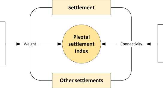
Let us make some methodological explanations. Terms “territories of advanced development”, “special/free economic zones” etc. are changed, in terms of Arctic territories, into “pivotal development zones”8. The key word is “pivotal”. However, the authors of scientific works, written in the 1970s–1980s, and legal documents use two key terms – pivotal and basic. These words have different functions, they are situated in the northern zone (or outside it) and have various population. To avoid misunderstanding and taking into account that the Arctic area is divided into nine pivotal zones (PZ), we use the term “pivotal settlements” (PS) in relation to arctic cities and urban-typed settlements which fit certain criteria.
Nowadays, there are 82 cities and UTSs (including 3 unpopulated UTSs), but not all of them could be called “pivotal”. Taking it into accounts, this research presents the author’s methodology of the Pivotal Settlement Index (PSI) calculation, which allows relating urban settlement to: 1) to a multifunctional pivotal settlement, 2) to a pivotal settlement, 3) a potential pivotal settlement , 4) a settlement which does not meet criteria of a pivotal one.
The construction of PSI is based on three methodological principles. The principle of complexity that includes simultaneous examination of natural-geographical, transport, socio-economic factors, investment activity, and takes into account their mutual influence. According to the principle of consistency , the Arctic area of the RF is considered a single space, but divided into several pivotal zones. The principal of agglomeration effect account is that a more compact allocation of population and enterprises leads to economy efficiency increase and investment attractiveness of the territory [17; 18].
PSI calculation of the Arctic is based on the concept of demographic gravitation. According to it, the demographic behavior follows the physic law: the magnitude of the interaction between two objects in space (for example, settlements) is directly proportional to the product of their mass and inversely proportional to the distance between them [19].
In demography, the concepts of “distance” and “mass” are usually interpreted in an extended way. Geographical distances, transport accessibility, social and economic connection of settlements are taken into account. Within the “mass” of the settlement framework, except the population numbers, its migration attractiveness, the economy volume, the situation on the labor market, and the quality of life can be analyzed. One of the most well-known options of the gravity model expansion in demography is the radiation model of population mobility, which takes into account the parameters of the entire network of settlements within a certain radius while determining the migration flow between two settlements [20].
The algorithm of PSI calculation includes the following stages. First, the weights of all Arctic urban settlements are calculated. Next, the matrix of connectivity between all AZRF urban settlements, taking into account their mutual transport accessibility and the distance, is calculated. Finally, the total PSI, showing the degree of compliance of each place with the pivotal settlement requirements, is determined for every city and UTS as the sum of weights and connections’ value products with all AZRF urban settlements (Fig. 1, form. 1 ).
PSI i = ∑ w iw jci , j , (1)
PSIi – pivotal settlement index i ; wi – the weight of the settlement i ; cij – the connectivity of the settlements i and j . The summand with j=i shows the contribution of the settlement to the final index, and summands with i ≠ j – the contribution of the other settlements connected to it.
The weight of a settlement is determined by the size of population and its socio-economic conditions in the urban district, or municipal area, where it is located. Four factors, which define the chances of urban settlements to become pivotal, were selected. The first two factors are the demographic situation and the labor market situation because exploration of the Arctic requires labor resources. Besides, economic and investment activities are taken into account. The more developed and attractive settlement economy is, the more opportunities for accumulation of the critical mass of investment projects, sufficient for developing the settlement and its nearby areas, exist.
Figure 1. Conceptual model of the Arctic pivotal settlement index
Demographic situation
Local labor market
Economic activity
Investment activity
у
Socio-economic conditions of UD and MD
Population number
Distance
Transport accessibility А
Automobile transport
Aerial transport
Water transport
Railway transport
Table 3. Table of transport accessibility assessment of cities and UTS in AZRF*
|
Transport type |
Transport accessibility |
Point |
|
Railway |
On the same railway On different railways of the federal network Connected by railway separated from federal network Not connected by railway |
0.25 0.15 0.10 0.00 |
|
Automobile |
Connected by federal auto road Connected by auto road Connected by auto road separated from federal network Not connected by auto road |
0.25 0.15 0.10 0.00 |
|
Aerial |
There are airports of federal importance There are airports There is no airport in, at least, one of the settlements |
0.25 0.15 0.00 |
|
Water |
Connected by sea ports Connected by river ports Not connected by water transport |
0.25 0.15 0.00 |
|
* Data taken from cities and settlements’ official web-sites, schemes from the official web-site of Russian railways, aerodrome and port registers from web-sites of the Federal Air Transport Agency and the Federal Agency for Maritime and River Transport were used. |
||
9 The database of indicators of municipalities. Russian Federal State Statistics Service. Available at: dbscripts/munst/
Thus, the higher the weight of the place and its surrounding settlements, the bigger the chances that it would become one of the pivotal settlements in the Arctic. Weight depends on the number of population and socio-economic situation in the urban district or municipal district (UD and MD) the settlement belongs to:
wi
k
= p- ■ 1 2
k j = 1
si j
-
j min
sj - sj max min
pi – number of population in the settlement i in thousands of people; sij – value of socio-economic indicator of j -UD/MD the settlement belongs to i (from 0 to 1); smaxj and sminj – maximum and minimum value of the indicator of all UD and MD respectively.
Eight indictors, which constitute four factors, of UD and MD9 socio-economic conditions are taken into account:
– demographic situation: coefficients of natural and migratory population growth rates;
– local labor market: average monthly wages of organizations’ employees, the ratio of the average number of organizations’ employees to the population numbers;
– economic activity: shipped goods of own production, own performed works and services (not including small businesses), the number of small and medium-sized businesses (per 10 thousand people);
– investment activity: the volume of investments into fixed capital (except for budget funds), investments into fixed capital at the expense of the municipal budget funds (per 1 person).
The influence that settlements have on each other is directly proportional to the coefficients of their connectivity calculated by the formula:
c = s ij
1, if i = j
, ,-(1 - 0,99 . log d _x („)) , if^ (3)
tij – transport accessibility between settlements i and j (from 0 to 1); dij – the distance between settlements i and j in kilometers; dmax – the distance between the most remote settlements between each other in kilometers.
Transport accessibility between settlements was calculated by summing four numerical values for different types of transport in accordance with Table 3.
The distance between cities and towns was with other settlements. It has two satellite cities determined according to their geographical – Murmansk and Severodvinsk. Novodvinsk is coordinates using the following variant of Vincenty’s formulae of arc’s length on a spheroid [21]10:
( cos ф i sin Д Я ) 2 + ( cos ф i sin ф j — sin ф i cos ф j cos Д Л )
sin ^ i sin ф j + cos ф i cos ф j cos ДЛ
d ij = R • arctan
ϕ i , λ i ; ϕ j , λ j – latitude and longitude of two settlements in radians; R – the radius of the Earth in kilometers.
According to Formula 3, the distance is converted according to a decreasing logarithmic scale. As a result, the connectivity between the most distant settlements of the Arctic zone (5551 km between Maloshuyka and Beringovsky) is equated to 1% of their transport accessibility, and 1 km distance between settlements – to 100%. The connectedness of the city with itself is assumed to be 100%.
Distribution of urban settlements of the Russian region of the Arctic according to the criteria of pivotal settlements
The algorithm of PSI calculation is implemented with the help of coding language Python 3. PSI was calculated for all 82 arctic settlements. For the following analysis, arctic settlements are grouped according to European (Tab. 4) and Asian (Tab. 5) parts of the Arctic. The following PSI scale is proposed for each group: 1) a multifunctional pivotal settlement – 60-175 ; 2) a pivotal settlement – 25-59; 3) a potential pivotal settlement – 10-2; 4) does not meet criteria of a pivotal settlement – 0-10.
The first group of multifunctional settlements includes Arkhangelsk, Murmansk, and Severodvinsk. Among Arctic settlements, Arkhangelsk has the highest index of pivotal settlement which is caused by the size of the city itself and high degree of its connectivity located 19 km away from Arkhangelsk. It is a highly specialized city, which can be attributed to the type of a monocity with natural problems of such settlements. Severodvinsk is 34 km
(4) away from Arkhangelsk. It is a special city – the citadel of MIC, the largest shipbuilding and ship repair center in the Arctic. The population within a radius of 100 km from Arkhangelsk is about 600 thousand people: it is a quarter of the total population of the Russian Arctic zone.
The population within a radius of 100 km from Murmansk, including Severomorsk and the settlements of Kolsky MD, exceeds 450 thousand people, making it the second largest pivotal settlement of the Russian region of the Arctic. Murmansk sea port is one of the largest ports in Russia, as well as the largest and ice-free port of the Northern Sea Route. The third position of Severodvinsk is caused by its advantageous geographical location near Arkhangelsk, great human potential, and the presence of a seaport.
The second group of pivotal settlements includes 6 establishments, 6 of them are situated in the European part of the Arctic. We can point out three cities: Apatity, Vorkuta, and Naryan-Mar. Apatity is one of the biggest science-centers in the Arctic, which possesses high human potential. It is situated in the center of the Kola pivotal area. Vorkuta is the only city in the Vorkuta pivotal area. It serves a center of settlement for many densely located urban settlements. Naryan-Mar is the only city in the Nenets pivotal zone: this fact explains its leading role.
The third group includes 20 urban settlements, 13 of which are located in the European part of the Arctic. The largest of them in population numbers are Novodvinsk, Olenegorsk, and Kem. The latter city has the
highest PSI in the Karelian pivotal zone, which makes it a local center of the development.
The fourth group is the largest. It consists of settlements that do not meet the criteria of a pivotal settlement – 50. 30 of them are located in the European part of the Arctic. In terms of population, Polyarny, UTS Vorgashor, Iskateley, Loukhi, Mezen stand out (Tab. 4).
There are 31 urban settlements in the Asian part of the Arctic (39.7%).
The first group of multifunctional settlements includes three cities: Novy Urengoy, Noyabrsk, and Norilsk. Novy Urengoy and Noyabrsk are two outposts of the oil and gas industry in Western Siberia. Norilsk is one of the largest centers of non-ferrous metallurgy in the world.
Table 4. Pivotal Settlement Indices of the European part of AZRF, 2017
|
IOP rank |
City or UTS |
Pivotal Settlement Index |
including: |
Population, thousand people |
Socio-economic condition of UD and MD |
|
|
center |
other settlements |
|||||
|
1 |
Arkhangelsk pivotal zone Arkhangelsk |
174.8 |
89.3 |
85.5 |
351.5 |
0.25 |
|
3 |
Severodvinsk |
92.4 |
43.0 |
49.4 |
184.0 |
0.23 |
|
20 |
Onega |
16.9 |
2.4 |
14.5 |
19.4 |
0.12 |
|
28 |
Novodvinsk |
11.7 |
6.6 |
5.1 |
38.7 |
0.17 |
|
43 |
Mezen |
5.2 |
0.7 |
4.5 |
3.3 |
0.20 |
|
47 |
Maloshuyka UTS |
3.8 |
0.3 |
3.5 |
2.5 |
0.12 |
|
51 |
Belushya Guba UTS |
3.2 |
0.7 |
2.5 |
2.4 |
0.29 |
|
62 |
Camenca UTS |
1.8 |
0.4 |
1.4 |
2.1 |
0.20 |
|
2 |
Kola pivotal zone Murmansk |
169.7 |
79.7 |
90.0 |
298.1 |
0.27 |
|
7 |
Apatity |
42.8 |
10.4 |
32.3 |
56.4 |
0.19 |
|
8 |
Monchegorsk |
36.4 |
8.7 |
27.7 |
42.6 |
0.20 |
|
11 |
Kandalaksha |
31.7 |
5.4 |
26.3 |
32.0 |
0.17 |
|
15 |
Olenegorsk |
23.8 |
4.1 |
19.7 |
21.0 |
0.20 |
|
16 |
Severomorsk |
23.4 |
5.1 |
18.3 |
51.2 |
0.10 |
|
17 |
Kovdor |
23.4 |
4.6 |
18.8 |
16.9 |
0.27 |
|
18 |
Polyarnye Zori |
22.6 |
3.9 |
18.7 |
14.6 |
0.26 |
|
22 |
Murmashi UTS |
16.2 |
2.7 |
13.5 |
13.8 |
0.19 |
|
24 |
Kola |
16.2 |
1.9 |
14.3 |
9.7 |
0.19 |
|
25 |
Zapolyarny |
15.4 |
2.9 |
12.4 |
15.2 |
0.19 |
|
26 |
Nikel UTS |
12.9 |
2.2 |
10.7 |
11.6 |
0.19 |
|
29 |
Kirovsk |
11.3 |
5.8 |
5.5 |
26.7 |
0.22 |
|
35 |
Zelenoborsky UTS |
8.2 |
1.0 |
7.2 |
5.7 |
0.17 |
|
42 |
Polyarny |
5.3 |
1.8 |
3.5 |
17.6 |
0.10 |
|
44 |
Revda UTS |
4.5 |
1.5 |
3.0 |
7.9 |
0.19 |
|
45 |
Gadzhiyevo |
4.3 |
1.3 |
3.0 |
12.9 |
0.10 |
|
46 |
Snezhnogorsk |
4.3 |
1.3 |
3.0 |
12.7 |
0.10 |
|
49 |
Molochny UTS |
3.6 |
1.0 |
2.6 |
4.9 |
0.19 |
|
50 |
Zaozyorsk |
3.5 |
1.0 |
2.5 |
10.0 |
0.10 |
|
55 |
Umba UTS |
2.8 |
0.8 |
2.0 |
4.7 |
0.17 |
|
56 |
Safonovo UTS |
2.6 |
0.6 |
2.1 |
5.6 |
0.10 |
|
58 |
Pechenga UTS |
2.4 |
0.6 |
1.8 |
2.9 |
0.19 |
|
59 |
Kildinstroy UTS |
2.0 |
0.4 |
1.6 |
1.9 |
0.19 |
|
65 |
Verkhnetulomsky UTS |
1.5 |
0.2 |
1.2 |
1.3 |
0.19 |
|
66 |
Ostrovnoy |
1.2 |
0.2 |
1.0 |
1.9 |
0.10 |
|
72 |
Tumanny UTS |
0.9 |
0.1 |
0.8 |
0.6 |
0.19 |
End of Table 4
|
IOP rank |
City or UTS |
Pivotal Settlement Index |
including: |
Population, thousand people |
Socio-economic condition of UD and MD |
|
|
center |
other settlements |
|||||
|
9 |
Vorkuta pivotal zone Vorkuta |
32.3 |
13.5 |
18.8 |
58.1 |
0.23 |
|
33 |
Vorgashor UTS |
9.1 |
2.4 |
6.7 |
10.3 |
0.23 |
|
37 |
Severny UTS |
8.0 |
1.9 |
6.0 |
8.4 |
0.23 |
|
53 |
Zapolyarny UTS |
3.1 |
0.4 |
2.7 |
1.5 |
0.23 |
|
60 |
Komsomolsky UTS |
2.0 |
0.2 |
1.9 |
0.7 |
0.23 |
|
64 |
Yeletsky UTS |
1.6 |
0.1 |
1.5 |
0.5 |
0.23 |
|
80 |
Mulda UTS |
0.0 |
0.0 |
0.0 |
0.0 |
0.23 |
|
81 |
Oktyabrsky UTS |
0.0 |
0.0 |
0.0 |
0.0 |
0.23 |
|
82 |
Promyshlennyi UTS |
0.0 |
0.0 |
0.0 |
0.0 |
0.23 |
|
12 |
Nenets pivotal zone Naryan-Mar |
25.2 |
9.2 |
15.9 |
24.7 |
0.38 |
|
38 |
Iskateley UTS |
6.7 |
2.9 |
3.8 |
7.2 |
0.40 |
|
27 |
Karelian pivotal zone Kem |
12.9 |
1.8 |
11.0 |
11.6 |
0.16 |
|
31 |
Belomorsk |
10.2 |
1.3 |
9.0 |
9.9 |
0.13 |
|
40 |
Loukhi UTS |
6.1 |
0.4 |
5.7 |
4.1 |
0.11 |
|
48 |
Chupa UTS |
3.8 |
0.2 |
3.5 |
2.3 |
0.11 |
|
54 |
Pyaozersky UTS |
3.0 |
0.2 |
2.8 |
1.7 |
0.11 |
The second group of pivotal settlements includes only one city – Nadym, which is situated 290 km away from Salekhard – the center of Yamalo-Nenets AO. The area of the settlement is 185 sq. km. The basis of the economy is gas-oil production and gas transportation enterprises.
The third group includes seven urban settlements: Tarko-Sale, Salekhard, Labytnangi, Muravlenko, Gubkinsky, UTS Urengoy in Yamalo-Nenets AO, and Dudinka in Taymyr-Turukhansk PZ. The importance of Dudinka is largely caused by its connection with Norilsk, and Yamalo-Nenets settlements have high socio-economic characteristics, which increase the potential to become pivotal settlements.
The fourth group includes 20 urban settlements that do not meet the criteria of PS. Although many of them currently play a key role in the development of their pivotal zone by having a high intellectual potential [22; 23], or comparative advantages in certain areas, important for the economy of the Arctic [24, p. 11; 25]. They include: Igarka, Anadyr, and Pevek, Tiksi UTS (Tab. 5).
Thus, by using PSI and taking into account the importance of certain settlements for local settlement system, formation of pivotal development areas and their maintenance, creation of opportunities for accelerated AZRF socio-economic development, it is possible to suggest pivotal settlements for each arctic pivotal zone.
Arkhangelsk will be a pivotal settlement for the Arkhangelsk PZ, including Severodvinsk. Cities and UTSs were included in one PS if the distance between them was less than 50 km. There are two places of the development in the Kolsk PZ: Murmansk and Apatity-Monchegorsk. In the Vorkuta PZ – Vorkuta, including UTS Vorgashor. In the Nenets PZ – Naryan-Mar, including UTS Iskateley. In the Karel PZ – Kem-Belomorsk. In the Yamalo-
Table 5. Pivotal Settlement Indices of the Asian part of AZRF, 2017
|
IOP rank |
City or UTS |
Pivotal Settlement Index |
including: |
Population, thousand people |
Socioeconomic condition of UD and MD |
|
|
center |
other settlements |
|||||
|
4 |
Yamalo-Nenets pivotal zone Novy Urengoy |
75.0 |
39.0 |
36.0 |
113.3 |
0.34 |
|
6 |
Noyabrsk |
64.0 |
32.5 |
31.5 |
106.9 |
0.30 |
|
10 |
Nadym |
32.1 |
16.5 |
15.6 |
44.7 |
0.37 |
|
13 |
Tarko-Sale |
24.1 |
10.9 |
13.2 |
21.7 |
0.50 |
|
14 |
Salekhard |
24.0 |
17.0 |
7.0 |
48.5 |
0.35 |
|
19 |
Labytnangi |
19.6 |
7.9 |
11.7 |
26.3 |
0.30 |
|
21 |
Muravlenko |
16.6 |
9.3 |
7.2 |
32.5 |
0.29 |
|
23 |
Gubkinsky |
16.2 |
9.0 |
7.2 |
27.2 |
0.33 |
|
30 |
Urengoy UST |
11.1 |
5.1 |
6.0 |
10.1 |
0.50 |
|
34 |
Pangody UST |
9.0 |
4.0 |
5.0 |
10.7 |
0.37 |
|
39 |
Kharp UST |
6.5 |
1.5 |
5.0 |
6.1 |
0.26 |
|
63 |
Zapolyarny UST |
1.8 |
0.3 |
1.5 |
0.9 |
0.37 |
|
5 |
Taymyr -Turukhansk pivotal zone Norilsk |
71.0 |
60.4 |
10.6 |
178.0 |
0.34 |
|
32 |
Dudinka |
10.1 |
5.5 |
4.6 |
21.5 |
0.26 |
|
41 |
Igarka |
5.4 |
1.7 |
3.7 |
4.8 |
0.36 |
|
68 |
Dikson UST |
1.2 |
0.1 |
1.0 |
0.6 |
0.26 |
|
78 |
Snezhnogorsk UST |
0.2 |
0.2 |
0.0 |
0.6 |
0.34 |
|
36 |
Chukotka pivotal zone Anadyr |
8.0 |
6.0 |
2.0 |
15.5 |
0.39 |
|
57 |
Pevek |
2.6 |
1.2 |
1.4 |
4.5 |
0.27 |
|
61 |
Bilibino |
1.9 |
1.2 |
0.7 |
5.3 |
0.23 |
|
67 |
Ugolnye Kopi UST |
1.2 |
0.7 |
0.5 |
3.7 |
0.18 |
|
71 |
Egvekinot UST |
1.1 |
0.6 |
0.5 |
2.8 |
0.20 |
|
73 |
Provideniya UST |
0.9 |
0.4 |
0.6 |
2.1 |
0.18 |
|
76 |
Beringovsky UST |
0.5 |
0.1 |
0.4 |
0.8 |
0.18 |
|
79 |
Cape Schmidt UST |
0.1 |
0.0 |
0.1 |
0.1 |
0.20 |
|
52 |
North-Yakutsk pivotal zone Tiksi UST |
3.1 |
1.3 |
1.9 |
4.6 |
0.28 |
|
69 |
Chersky UST |
1.2 |
0.6 |
0.5 |
2.6 |
0.25 |
|
70 |
Chokurdakh UST |
1.1 |
0.6 |
0.5 |
2.1 |
0.28 |
|
74 |
Deputatsky UST |
0.9 |
0.9 |
0.0 |
3.0 |
0.31 |
|
75 |
Ust-Kuyga UST |
0.6 |
0.2 |
0.4 |
0.7 |
0.31 |
|
77 |
Nizhneyansk UST |
0.3 |
0.1 |
0.2 |
0.2 |
0.31 |
Nenets PZ – Novy Urengoy, Noyabrsk, and Nadym. In the Taymyr-Turukhansk PZ – Norilsk, Dudinka, and Igarka. In the Chukotka PZ – Anadyr, Pevek, and Bilibino. Also, there are three settlements in the northern Yakutsk PZ – Tiksi, Chersky, and Chokurdakh (Tab. 6) .
Using graphical and cartographic methods, we illustrate the impact of two factors: the potential of the settlements to serve as pivotal centers for the Arctic development and their connectivity with other settlements in the existing settlement system. Settlements with a high impact from the first factor are located on the right side of the plane, those with a high impact from the second factor – above. The size of the circles in the scattering diagram is proportional to the index value (Fig. 2).
Table 6. Impact of connectivity on the definition of pivotal settlements according to PZ of Russian region of the Arctic
|
Pivotal zone |
Settlement |
Distance, km |
Settlement |
|
Arkhangelsk |
Arkhangelsk |
34 |
Severodvinsk |
|
Arkhangelsk |
19 |
Novodvinsk |
|
|
Severodvinsk |
50 |
Novodvinsk |
|
|
Kola |
Murmansk |
158 |
Apatity |
|
Murmansk |
116 |
Monchegorsk |
|
|
Apatity |
47 |
Monchegorsk |
|
|
Vorkuta |
Vorkuta |
15 |
Vorgashor UTS |
|
Nenets |
Naryan-Mar |
8 |
Iskateley UTS |
|
Karelian |
Kem |
49 |
Belomorsk |
|
Yamalo-Nenets |
Novy Urengoy |
327 |
Noyabrsk |
|
Novy Urengoy |
197 |
Nadym |
|
|
Noyabrsk |
296 |
Nadym |
|
|
Taymyr -Turukhansk |
Norilsk |
80 |
Dudinka |
|
Norilsk |
220 |
Igarka |
|
|
Dudinka |
217 |
Igarka |
|
|
Chukotka |
Anadyr |
633 |
Pevek |
|
Anadyr |
615 |
Bilibino |
|
|
Pevek |
240 |
Bilibino |
|
|
North-Yakutsk |
Tiksi UST |
1248 |
Chersky UST |
|
Tiksi UST |
691 |
Chokurdakh UST |
|
|
Chersky UST |
557 |
Chokurdakh UST |
Figure 6. Distribution of urban settlements of the Russian Arctic according to PSI


Severodvinsk

Norilsk orkuta
Apatity
0 10 20 30 40 50 60 70 80 90
Weight of pivotal settlement
Novy Urengoy
• European part of AZRF
Arkhangelsk
о Asian part of AZRF
Figure 3. Pivotal settlements of the Russian region of the Arctic
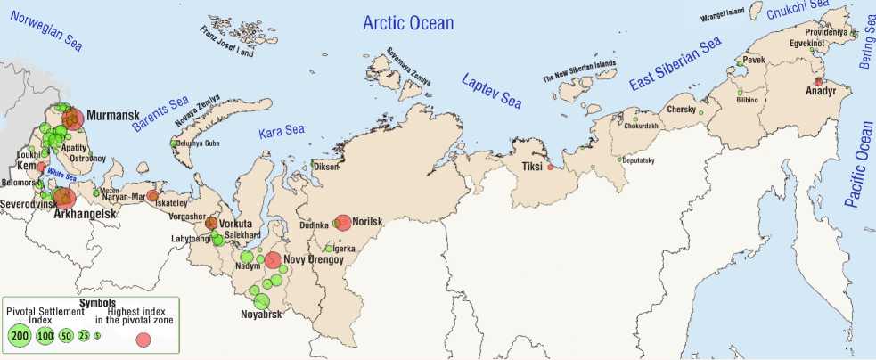
The diagram shows that Asian settlement indices are negatively affected by a more sparse settlement system. The most striking example is Norilsk, which has extremely low transport accessibility and is remote from other major centers. European settlements receive more cumulative effect from the neighboring villages and better transport infrastructure.
On the map we see the main pivotal settlements of the Russian region of the Arctic, the size of the circles is also proportional to the indices of settlements (Fig. 3) .
Conclusions
A number of conclusions and suggestions can be drawn from the analysis:
-
1. It is proved that Arctic cities should have limits of growth: the optimal size of urban settlements is in the range of 50–100 thousand inhabitants; it is recommended not to form new permanent settlements in areas with unfavorable medical and geographical conditions;
-
2. For the future, authorities suggest the transition from the residence policy to the policy of non-indigenous population staying in the Far North;
-
3. It is necessary to improve the division of labor between the Northern regions and the main settlement areas, to develop the pivotal centers of Northern development in them; the procession of the “Northern resources” is available in basic settlements, located in the middle North;
-
4. Taking into account the new role of the Arctic in socio-economic development of Russia, the negative trends of decreasing number of settlements’ population, we grouped arctic cities and UTSs according to the pivotal settlement criteria with the help of suggested algorithm of PSI calculation. It allowed us to suggest development centers for each pivotal zone of the Arctic. The basic settlements, having special value, but meeting the criteria of basic settlements, are proposed for several PZ (Igarka, Tiksi, Anadyr, and Pevek).
The scientific and practical relevance of the work is the formalization of the “pivotal settlement” concept, which can be used in the development of strategic documents on the Arctic territories exploration and the spatial development of Russia.
Further studies should focus on the forma- management of the demographic and labor tion of public policy measures for the optimal potential of each analyzed settlement group.
References Methodology for defining pivotal settlements in the Russian Arctic
- Panov L.K., Semenov S.P., Shimanovskaya Z.F., Belinskii A.Yu., Kadnikov V.V. Forecast of Settlement and Planning of Far East New Cities. Ed. by L.К. Panov. Leningrad: Stroiizdat (Leningrad department), 1974. 200 p.
- Andreeva E.N. Pivotal zones in the Arctic: new ways of solving old problems. EKO, 2017, no. 9, pp. 26-41.
- Kondrat'eva V.I. North-Yakutsk pivotal zone of the Arctic zone of Russia in the strategy of Russian Federation spatial development. Arktika. XXI vek. Gumanitarnye nauki=Arctic. 21st Century. Humanities, 2017, no. 1 (11), pp. 4-12. (In Russian).
- Lazhentsev V.N. Spatial development (on the example of the North and the Arctic). Izvestiya Komi nauchnogo tsentra UrO RAN=Proceedings of the Komi Science Centre of the Ural Division of the RAS, 2010, no. 1, pp. 97-104. (In Russian).
- Dmitrieva T.E. Methodological context of spatial development of the Northern region. Ekonomika Severo-Zapada: problemy i perspektivy razvitiya=Economy of the North-West: Issues and Prospects of Development, 2009, no. 1, pp. 22-29. (In Russian).
- Panov L.K. Settlement systems and environmental protection in the North. In: Problemy Severa [Problems of the North]. Moscow, 1973. No. 18. (In Russian).
- Khodzhaev D.G., Vishnyakova V.S., Glabina N.K. Effektivnost' rasseleniya: problemy i suzhdeniya [The Efficiency of Settlement: Problems and Judgments]. Moscow: Mysl, 1983. 276 p.
- Pokshishevskii V. V. Geografiya naseleniya SSSR: ekonomiko-geograficheskie ocherki [Geography of USSR Population: Economic and Geographical Essays]. Moscow: Prosveshcheniye, 1971, 176 p.
- Sveshnikov V.K. Gradostroitel'nye problemy Severa: tezisy dokladov (Murmansk, sentyabr' 1971 g.) [Urban development problems of the North. Theses of reports (Murmansk, September 1971)]. Leningrad, 1971. Pp. 5-19.
- Kuznetsova O.P., Yumaev E.A. Pivotal city as a key link in the settlement system of the Russian Federation. Izvestiya Uralskogo gosudarstvennogo ekonomicheskogo universiteta=Journal of the Ural State University of Economics, 2010, no. 3 (29), pp. 113-118. (In Russian).
- Fauzer V.V., Lytkina T.S., Fauzer G.N. Pecularities of population settlement in the Arctic zone of Russia. Arktika: ekologiya i ekonomika=The Arctic: Ecology and Economy, 2016, no. 2 (22), pp. 40-50. (In Russian).
- Fauzer V.V., Smirnov A.V. Global Arctic: natural resources, population settlement, economy. Arktika: ekologiya i ekonomika=The Arctic: Ecology and Economy, 2018, no. 3 (31), pp. 6-22. 10.25283/2223-4594-2018-3-6-22. (In Russian).
- DOI: 10.25283/2223-4594-2018-3-6-22.(InRussian)
- Fauzer V.V., Smirnov A.V. Russian Arctic: from ostrogs to urban agglomerations. EKO, 2018, no.7, pp. 112-130. DOI: 10.30680/ЕСО0131-7652-2018-7-112-130. (In Russian).
- Gavril'eva T.N., Arkhangel'skaya E.A. Northern cities: general trends and national features. EKO, 2016, no. 3, pp. 63-79. (In Russian).
- Kryukov V.A., Kryukov Ya.V. How to expand the scope of Arctic projects. EKO, 2017, no. 8, pp. 5-32. (In Russian).
- Minakir P.A. The national strategy of spatial development: is it the conscientious delusion or deliberate simplification? Prostranstvennaya ekonomika= Spatial Economics, 2016, no. 3, pp. 7-15. (In Russian).
- Scott A., Storper M. The nature of cities: the scope and limits of urban theory. International Journal of Urban and Regional Research, 2014, vol. 39 (1), pp. 1-15.
- Walker R. Why cities? A response. International Journal of Urban and Regional Research, 2016, vol. 40 (1), pp. 164-180.
- Stewart J.Q. Demographic gravitation: Evidence and application. Sociometry, 1948, vol. XI, pp. 31-58.
- Simini F., Marta C.G., Amos M., Barabási A.-L. A universal model for mobility and migration patterns, Nature, 2012, vol. 484, pp. 96-100.
- Vincenty T. Direct and inverse solutions of geodesics on the ellipsoid with application of nested equations. Survey Review, 1975, vol. 23 (176), pp. 88-93.
- Petrov A. Creative Arctic: towards measuring Arctic's creative capital. Arctic Yearbook 2014. Ed. by L. Heininen. Akureyri: Northern Research Forum, 2014. Pp. 149-166.
- Petrov A. Exploring the Arctic's "Other economies": knowledge, creativity and the new frontier. The Polar Journal, 2016, vol. 6, no. 1, pp. 51-68.
- DOI: 10.1080/2154896X.2016.1171007
- Healy A. Innovation in circumpolar regions: new challenges for smart specialization. The Northern Review, 2017, no. 45, pp. 11-32.
- DOI: 10.22584/nr45.2017.002
- Jungsberg L., Copus A., Nilsson K., Weber R. Demographic Change and Labor Market Challenges in Regions with Largescale Resource-Based Industries in the Northern Periphery and Arctic. Stockholm: Nordregio, 2018. 42 p.
