One hundred years of the geobotanical research in the Murmansk region: history, modern position and problems

Author: Koroleva N.V.
Journal: Arctic and North @arctic-and-north
Section: Biological Sciences
Article in issue: 7, 2012.
Free access
This article provides an overview of trends and current status of Geobotany in the Murmansk region, with particular attention to the problems of modern geo-botanical studies. Emphasizes the importance of regional geo-botanical studies and preparation of students of geo-botanical biological specialties.
Geobotanics, the science of vegetation, phytosociology, ecological assessment, Kola encyclopedia, the History of the Science, the Higher Education, Murmansk Region
Short address: https://sciup.org/148320431
IDR: 148320431 | UDC: 581.9:165.9(1−924.16)
Text of the scientific article One hundred years of the geobotanical research in the Murmansk region: history, modern position and problems
More than 270 thousand species of vascular plants, 24 species of bryophytes thousand and 25 thousand species of lichen forming innumerable plant communities that cover a continuous film of different power the entire Earth, with the exception of the oceans and glaciers. It is in the plant communities is the main cycle of matter and energy. Plant communities form a single system with a soil cover areas with plant communities associated habitats and life cycle of animals. The vegetation cover is the most expressive component of the landscape. The natural diversity of land cover is the basis of its biological diversity, which is recognized as samotsennostnaya category, re--‐ gardless of the human society.
A special place in the sciences of the Earth's vegetation is geobotany –the science that studies the diversity, properties, relationships, and to determine regularities of the organization and development of the spatial distribution of plant communities. It is a synthetic science at the interface of biological and geographical sciences, a member, as in the biological sciences, and in the earth sciences. Compared with other "classical" biological and geographical disciplines her age is relatively small. Formation of a theoretical framework Geobotany began with studies of the great German naturalist Alexander von Humboldt (1767--‐1835). In Russia, convincing the Depart--‐ ment of the vegetation from other botanical sciences took place in the last quarter of the XIX cen--‐ tury. Making basic terminology geobotanical happened at the Brussels International Botanical Congress in 1910, which was the basis for the recently noted a century "official" creation geobota--‐ ny.
Geobotany in the broadest sense includes the geography of plant Communities, plant ecol--‐ ogy and phytosociology [52]. Sometimes the term is regarded as a synonym phytosociology Geo--‐ botany, and then it turns and the geography of vegetable communities [11]. Different, though re--‐ lated sciences believes Geobotany and fi--‐togeografiyu (geography of plants and vegetation) RV Kamelin [20]. Although phyto--‐geography as part of part of biogeography (at least in the university curriculum), and plant ecology has long been an independent discipline geobo--‐Tunica in Russia is developing a kind of "fusion" of these three sciences, which together form the methodology geo--‐ botany her conceptual apparatus and the main issues. In European English literature synonymous with "geobotany" is «phytosociology» and «phytocoenology», in American --‐ «synecology», partly «vegetation (plant) ecology» and «biogeography», in the German --‐ «die Pflanzensociologie» and «die Geobotanik»).
One of the main methods of the execution remains geobotanical descriptions (Picture 1) and their subsequent processing. Despite its apparent simplicity and the "old--‐fashioned" geobo--‐ tanical descriptions of their scientific value is very high. While satisfied--‐tion of every description estimated alpha--‐diversity of the community, a common set of definitions is beta diversity of a ter--‐ ritory, and the complete list of all descriptions (synoptic table) is its gamma diversity. Geobotanical description must necessarily include agamous component communities (bryophytes and lichens, often prevalent in species composition and phytomass), without taking into account the descrip--‐ tion of the tundra, swamp, forest vegetation can not reflect its actual composition. Description contains the necessary related information such as location coordinates the data on the physical and geographical, geological and ecological characteristics of the location, on soils with anthropo--‐ genic impact. Mandatory assessment of the phenological state of the plants, the horizontal struc--‐ ture of the vegetation (drawings, diagrams, photographs). The information obtained in the per--‐ formance of the geobotanical descriptions, making it rather a "model" than "description" [13].
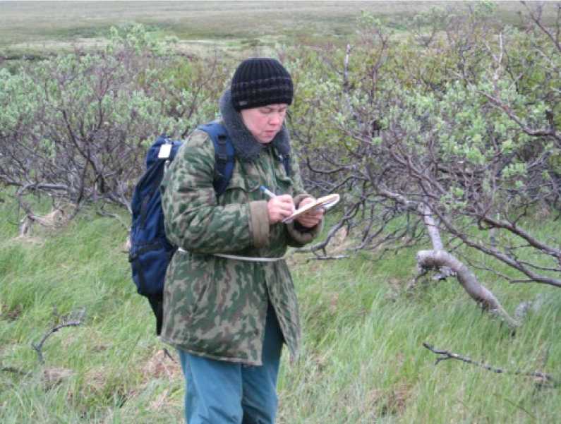
Performing the geobotanical descriptions fragments in the birch forests in the tundra zone. The land of the Lumbov--‐ skiy Bay of the White Sea (July 2007)
If we take into the account that for a limited time at an area geobotanist should represent--‐ atively evaluate the diversity of vegetation and to make at least ten definitions for each type of pre--‐allocated to them, to properly collect and, most importantly, keep herbarium before deter--‐ mining in the laboratory, it becomes clear why is it difficult to get quality primary geobotanical da--‐ ta and why they are important to science. Perhaps correctly assembled geobotanical data --‐ one of the few examples of scientific information, the value of which is not lost over time, and growing, and which can always find a new application for example in the study of the recent history of veg--‐ etation.
Important condition to the success in the geobotanical research – are the publications geo--‐ botanical primary data --‐ processed descriptions. This is the only way "... to objectify inventory and classification of plant communities, comparisons of all types of communities in whatever areas they were described and in any classification system ... not presented" [30, p. 95]. That's a huge amount of published geobotanical descriptions allowed to execute in the European Union impres--‐ sive project --‐ development of a database for a "Survey of vegetation in Europe" and "vegetation maps of Europe" [71]. Publication of primary data geobotanical must accompany their synthesis and analysis, since, in fact, is what makes Geobotany science, not just skilled in gathering facts.
In Russia geobotany is probably one of the most "mass" botanical sciences, for example, to participate in the XII Congress of the Delegates of the Russian Botanical Society on sec--‐tion "Geo--‐ botany" was presented to 170 applications. As a result, this section was the most numerous at the Congress, participated in the work of more than 70 professionals [39] The last All--‐Islamic Confer--‐ ence "National geobotany: milestones and prospects", held in 2011 in St. Petersburg, attracted 235 participants from different regions of Russia and abroad.
There are several comprehensive reviews of the history and the development of Geobota--‐ ny in the world and in Russia [3, 53, 16, 47], adequately set out the material and textbooks geo--‐ botany and phytocoenology [11, 46, 17, 31]. This article examines in detail the history, current sta--‐ tus and problems geobotanical science in the Murmansk region.
«Road map» for the geobotanic in the Murmansk region
The most important results of the geobotanical works of the last century. Foundation for the study of vegetation area was laid out in the 30--‐40's of the XIX century, during the first geo--‐ graphical expeditions of the St. Petersburg Academy of Sciences under the leadership of K. E. Baer (1792--‐1876). On the Kola Peninsula included such leading Russian scientists as A. Middendorf (1815--‐1894), AG Schrenk (1816--‐1876), FI Rupprecht (1814--‐1870), etc. The first major geobotanical generalization was survey in 1911--‐1914 professor at the University of Tartu in K. Regel (1890--‐ 1970) some areas of the Kola Peninsula, on the instructions of the St. Petersburg Society of Natu--‐ ralists. This first and very high quality geobotanical work on the Kola Peninsula can start counting the development of local geobotany. The task of collecting Regel considered as possible and com--‐ plete the extensive evidence of vegetation, "because all the hypotheses are transient" [70, Vor--‐ wort, VIII].
Detailed studies of vegetation led to the former Finnish (the Tartu Treaty of 1920) in the Kola Peninsula Finnish botanists [64, 65, 69].
Powerful incentive was developed geobotanical studies beginning of the Soviet develop--‐ ment of natural resources of the Kola region. In several expeditions of the Academy of Sciences of the USSR on the Kola Peninsula worked outstanding researcher North Y.D. Zinserling1 .(Figure 2). His pomarshrutny review and vegetation map of the north--‐east of the Kola Peninsula were then used to create the maps, review and botanical--‐geographical zoning of vegetation north of the Eu--‐ ropean part of the USSR [55, 56, 57]. As in other areas of the Far North, in the Murmansk region to conduct a detailed description and map--‐firovanie vegetation as a resource for the reindeer [49].
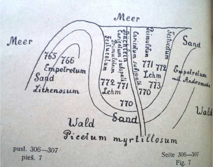
Picture 1. K. Regel [70, 306--‐307]. Illustration--‐ plan cover on the coast of the bay Pirya Guba, Kandalaksha Bay of the White Sea
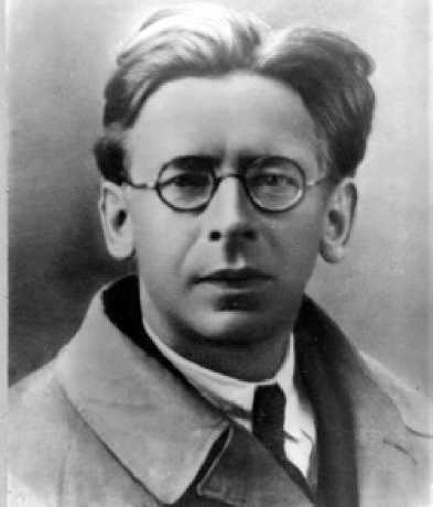
Picture 2. Yuriy Dmitrievich Zinserlin
One of the first papers published by the employees in 1931 in Kirovsk Polar Alpine Botani--‐ cal Garden (now PABSI KSC RAS) were map and description of the vegetation of the Khibiny Moun--‐ tains [1]. Important scientific event was the "Vegetation Map of the Kola Peninsula (1:1 000 000)," the staff member PABSI EG Chernov [59]. Explanatory text to the map contains the most compre--‐ hensive analysis of the floristic and geo--‐botanical studies in the Murmansk region since the end of
XVIII to the mid XX century, the description of the illustrations and the major types of communi--‐ ties, the survey identified the author geobotanical regions. Subsequently, "Vegetation Map of the Kola Peninsula" was generalized and became part of "Map of the vegetation of the European part of the USSR (1:2 500 000)" [21] and the "Soviet geobotanical map (1:4 000 000)" [12], the it is based on vegetation maps created in the "atlas of the Murmansk region" [4] and the "Environ--‐ mental Atlas of the Murmansk region" [61].
Detailed descriptions, dynamics analysis, productivity assessment consorts connection, as well as large--‐scale maps and coastal vegetation ornithogenic Kandalaksha reserve (as in the Bar--‐ ents Sea, and on the White Sea coast) were performed by I.P. Breslin [8, 9]. Not only the classifica--‐ tion of vegetation Lapland Reserve, but a comparison with other mountain systems Fennoscandia leads TP Nekrasov [32, 33]. Succession on cuts and burns Lapland Reserve focused research NM Pushkin [44, 45]. A major generalization of geo--‐botanical and floristic studies of two neighboring regions was an analytical review of flora of the Murmansk region and Karelia [48]. Concise geobo--‐ tanical characteristic landscape provinces remains the most frequently cited in a variety of modern printing works on the nature of the area. Existing body of knowledge about the vegetation of the area, along with data from other areas of the Holarctic, a number of important generalizations of large areas. First of all its geobotanical zones Arctic and Antarctic [2], botanical--‐geographical re--‐ gionalization of the tundra and taiga of the European part of the USSR [14, 19], etc.
Modern geobotanical research. Currently, the permanent geobotanical research in the Murmansk region is employees of the Polar Alpine Botanical Garden--‐Institute RAS, Botanical Insti--‐ tute. Komarov Academy of Sciences, the Institute of North Industrial Ecology Problems, RAS, Kola Nature Conservation Centre, Centre for Ecology and Productivity of Forests. The study of vegeta--‐ tion reserves attracts staff of the St. Petersburg Forest Technical Academy, St. Petersburg State University, Institute of Biology and Institute of Forestry, Karelian Research Centre of RAS. The vol--‐ ume of articles makes it impossible to go into all the geo--‐botanical studies. Considering the current state of regional Geobotany for example the main publications of the last two decades, it can be argued that most studied syntaxonomic variety of area and mountain tundra and forest tundra of the Murmansk region, published descriptions of tables and pivot tables, and made prodromus as--‐ sociations [22, 23, 24, 66; 67]. Certain types of vegetation of the Kola Peninsula in the coastal communities, tundra and forests of the Euro--‐Arctic and Subarctic are considered in comparative geobotanical surveys [50, 27, 28, 63] (Figure 3). Ratio analysis of geographic elements in the num--‐ ber of vascular plant communities and comparison to similar communities surrounding tundra, forest tundra and northern taiga region will clarify the position of treeless territory's northern Murmansk region in the zoning system [60].
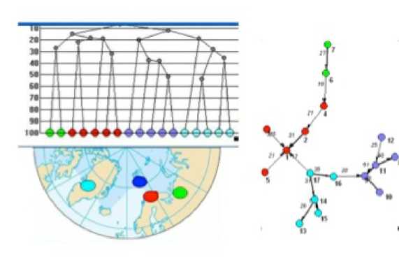
Figure 3. Dendrogram and the similarity between the dendrite syntaxa driadovyh in tundra (associations, types of communities, the types of tundra) Fennoscandia (including the Murmansk region), Svalbard, Greenland and East Eu--‐ ropean tundra (used similarity coefficient Serensena Czekanowski--‐based indicators of activity) (at [26; 27])
Long--‐term studies of vegetation are in the reserves of the Murmansk region. On the terri--‐ tory of the largest in the Lapland Reserve describes the main forest association [37,38], and moun--‐ tain--‐tundra vegetation [67] performed a classification and review of the major plant communities of the reserve "Pasvik [36]. Overview of environmental systems and landscape map Pasvik Reserve [41] geobotanical contain valuable information and can be used for classification of plant systems and map the vegetation of the reserve.
During the soil biogeozenologicheskiyresearch studied the composition and the structure of plant communities. Biogeotsenologicheskii research in plant communities of mountain tundra and mountain--‐belt showed differences in the structure of biomass, as well as the accumulation and distribution of carbon in the structural components of the communities on the topographic gradient [54, 72]. Analysis of the transformation of matter flows in the plant communities of co--‐ niferous forests revealed the need to take into account the spatial structure of the community in the evaluation of anthropogenic impact [40].
«Most large bibliography of studies of vegetation in the area of Murmansk industrial im--‐ pact. In various types of forests in the area of pollution plant "Severonikel" Kola Peninsula had signs, diagnoses infestation communities of pine forests, we investigate the stability and recovery processes phytocenoses examined changes in the composition and structure of edificator synusiae and subordinates on the gradient of pollution [62]. According to the route and experimental study of vegetation dynamics at constant atmospheric pollution and the occasional catastrophic events (forest fires), a forecast of forest restoration in different types of human activities [15], we consid--‐ er restoration succession in north--‐boreal spruce forests at lower levels of pollution [58]. Through the study of long--‐term dynamics of forest communities concluded conifer green moss forests on drained sandy soils, as the final stage of pyrogenic succession [35]. In the study of fungal compo--‐ nent in the structure of forest plant communities studied the dynamics of wood--‐destroying fung in various stages of post--‐fire succession in the northern taiga forests [18].
Typological mapping in the Murmansk region is both a result and a means of understanding the major regional structural features and the vegetation cover. Based on the analysis of ground and remote information (aerial photographs and satellite images) was established "Vegetation map of the central part of the Murmansk region (1:100 000)," which also includes most of the Lap--‐ land Nature Reserve, as well as mountain Khibiny and техногеннотрансформированные neigh--‐ borhood Steel Works " Severonikel "[42]. Using various remote sensing and field data the current status and differentiation factors of vegetation, and the impact of various human activities on the composition and structure of the vegetation of the area [43]. For the parts of Lapland Reserve conducted mapping of vegetation in the scale of 1:50 000 [34]. To map legend tundra and forest--‐ tundra vegetation of proposed types of tundra and forest habitats on grounds of plant communi--‐ ties and communities in the landscape position [25, 28].
Contribution to the theoretical basis for the environmental action in the Murmansk region was phytocenotic activity analysis of the "Red" and the selection of the most valuable habitat types [5, 26]. The result, in particular, was the conclusion cenotical conjugacy number of rare spe--‐ cies of vascular plants and their relationship to rare types of plant communities [6] as well as con--‐ ditioning cenotical groups of rare species of mosses, lichens and cyanoprokaryota [7].
Great work on the inventory of the most valuable for biodiversity conservation areas in the north--‐west of the European part of Russia had a large group of researchers [51]. The purpose of this study was an assessment of the current state of vegetation by a single method, which is based on --‐ the use of remote sensing data to obtain the most objective and relevant results. Unfortu--‐ nately, as a review of valuable habitats and maps, at least for the Murmansk region, carried out geobotanical context. If the authors had full use of the available theoretical geobotany hurt, then for a given quantity and quality of remote sensing materials, and an exceptionally high level classi--‐ fication of images could be obtained with the results of great scientific value.
Thus, the current range of geo--‐botanical studies in the Murmansk region is extremely rich and varied and, in general, representative reflects the direction of Geobotany in Russia. These are: an inventory and mapping of vegetation, forming bases geobotanical data to determine the posi--‐ tion of the Murmansk region in regional and circumpolar systems geobotanical data clarify the ways of the historical development of vegetation, assessment, analysis of the dynamics and struc--‐ ture of vegetation in the areas of human impact (including when using remote sensing) and to identify the most valuable types of plant communities and the development of the necessary measures to protect them. Nevertheless, the "density" of the research in the region is extremely uneven.
The most studied part of the development of the Central Forest and vegetation of eastern and north--‐eastern part of the area studied is quite insufficient, mainly due to the inaccessibility of the area. Further study and classification of old--‐growth forests in the south and south--‐east region. Remain poorly understood swamp area --‐ one of the most prevalent area, species and structural diversity of vegetation types. Especially important to create a map of modern vegetation Mur--‐ mansk region on the basis of field data and remote information, as current map over half a centu--‐ ry, and modern large--‐scale geo--‐botanical maps cover only a small part of the more developed are--‐ as.
The problems of the development of the geo–botanic research in the Murmansk region
Modern geobotany largely implemented as a knowledge--‐based technology. This is how the data are used geobotanical geobotanical examination as part of the EIA for the specification and certification of protected areas in different fitoindikatsionnyh studies, as well as typological geo--‐ botanical mapping. Further socio--‐economic development of the Murmansk region is associated with the development of its natural resources for sustainable and long--‐term uses of and the for--‐ mation of a balance between the development of the region and the conservation of its biological diversity. This is why the region need qualified ecologists, have a "technological" geobotanical knowledge, able to cope with the complex problems of inventory of natural resources (including the cover), environmental impact assessment and monitoring of human impact on terrestrial fito--‐ biotu.
Currently, the field of «environment» and «ecology and nature» is preparing students three higher educational institutions of the Murmansk region, but their training programs do not rate geobotany. Such courses are students Geoecology AF Bauman, but in 2011 he was dropped from the curriculum. Thus, the base level of knowledge for students geobotanical Murmansk re--‐ gion is not available. The same situation with some other biological disciplines, in particular, to teaching students ecologists and biologists are not involved experts active in the field of research and protection of ground fitoraznoobraziya. As a result, students do not get a complete picture of the present state of science on biodiversity, on the composition and methods of studying the ground fitobioty and ways of scientific results into the practice.
The lack of even basic environmental, geo--‐botanical knowledge of the initial causes some--‐ times surprising results of environmental assessment. For example, in a report on land Geobotani--‐ cally monitoring in the zone of influence of the «Severonickel" presented combine in 2010--‐2011, one of the project of the Murmansk region, suggested a study "pioneer plants --‐ mosses and li--‐ chens." Lichen described here as "color spots", and concluded that "the spread of moss and li--‐ chen," and increase the area of "color spots" evidence of the improvement of environmental con--‐ ditions.
But the foundation of any, even the simplest geobotanical survey --‐ is a list of species (in--‐ cluding mosses and lichens) and their quantitative assessment. SOIL variety of lichens, making up these "color spots" may exceed several dozen species, not all of them --‐ "pioneer", yes, in general, and not plants. Their development is associated with a reduction in competitive pressure of vascu--‐ lar plants and soil disturbance and very indirectly --‐ from environmental contamination. Draw any conclusions about the improvement or deterioration of ecological environment, based on the state of vegetation, can not be carried out without the correct geo--‐botanical survey and analysis, with which the text has nothing to do. In general, given the high level of scrutiny of the vegetation cover and detailed long--‐term monitoring of his condition in the area of influence of the «Severon--‐ ikel" efforts of scientists of several academic institutions, the emergence of these "assessments" --‐ an indicator of a lack of demand for business--‐quality scientific production. Has dire consequences the lack of basic education geobotanical the authors and editors of regional training, reference and encyclopaedias in biology. In particular, recently published the first two volumes of "The Ency--‐ clopedia of Kola" [10] in terms of essays on vegetation areas contain outdated and incorrect in--‐ formation, and, unfortunately, can not be used as a reference scientific manual.
Conclusion
Observed "parallel" of the development of the scientific geobotanical research and the practical applications of their results --‐ an indicator of the destruction of the social contract be--‐ tween science and society. Exclusion and lack of continuity geobotanical knowledge at regional and local level can lead to irreversible consequences. Young professionals, environmentalists and biologists have now have little idea of what the vegetation area, and Russia as a whole, and that is growing under their feet. Environmental impact statement did not give a real idea that we could lose because of a human impact. Training and resource materials in biology of knowledge about plants, "frozen" in the state of the last century. Absence Geobotany in training programs not only reduces the quality of regional biodiversity and environmental education, but also may affect the socio--‐economic development of the area. There is an urgent need for a training course in the pro--‐ gram Geobotany biological and environmental departments of the universities of the Murmansk region and the use of teaching knowledge and experience of practitioners--‐geobotanists of insti--‐ tutes of the Academy of Sciences.
Thanks to S.V. Chinenko (BIN RAS) and E.A. Borovicheva (PABSI KSC RAS) for the construc--‐ tive discussion of the main provisions of the article.
References One hundred years of the geobotanical research in the Murmansk region: history, modern position and problems
- Avrorin N.A., Kachurin M.H., Korovkin A. Materials Vegetation Khibiny Mountains // Proc. CSPF USSR. Ser. Kola., 1936. No. 11. Pp. 3-95.
- Alexandrova V.D. Geobotanical zoning Arctic and Antarctic. L., 1977. 189 p.
- Alexandrova V.D. Classification of vegetation. Overview of the principles of classification and classification systems in different geobotanical schools. Nauka, Leningrad, 1969. 275p.
- Atlas of the Murmansk region. M. GUGK, 1971.
- Blinov IV Biology orchids in northeastern Fennoscandia and strategies for their survival on the northern border of the / / Author. disc. ... Doctor. biol. Science. M., 2009. 44p.
- Blinov I. Population studies of rare species of vascular plants in the Murmansk region // In. "The diversity of plants, lichens and cyanoprokaryota Murmansk region: results and prospects of the study." A team of authors, ed. Ed. N. Konstantinov. St. Petersburg, 2009. Pp. 90-100.
- Borovich EA, VA Kostin, Shalygin SS Some key plant areas Lapland Reserve (Murmansk region) // Proceedings of the Karelian Research Center of Russian Academy of Sciences, Ser. Biogeography. 2011. № 9, № 11 (in press).
- Breslin I.P. The flora and vegetation of the Ionian Islands and adjacent coast of East Murman. Diss. to the competitor. Art. Candidate. biol. Science. Kandalaksha, 1970. 339 p.
- Breslin I.P. The plants and waterfowl sea islands Kola Sub-Arctic. L., 1987. 199. 10. Voronin AV, Agarkova TV etc. Kola Encyclopedia / Scientific-ed. Tip: Evdo-Kim Yu (preds.). St. Petersburg: IP; Apatity: RAS, 2008, 2009. Vols 1 and 2. 1048 from.
- Voronov A.G. Geobotany. Textbook. Allowance for un-ing and ped. In-tov. Ed. 2nd, rev. and add. M., "High. School "
- Geo-botanical map of the USSR. 1:4 000 000. Ans. VB editor Sochava. M. GUGK, 1955.
- Golub V.B. Using geobotanical descriptions as a collection of samples for classification of vegetation / / Vegetation Russia. 2011. № 17-18. Pp. 70-82.
- Gribov S.A. The latitudinal differentiation tundra vegetation European Plain / / Problems of Ecology, geobotany botanical geography and floristics. Nauka, Leningrad, 1977. Pp. 37-46.
- Dynamics of forest communities in Northwest Russia / Ed. Ed. VT Yarmishko. SPb.: BIN RAS, 2009. 275p.
- Dokhman G.I. Geobotany history in Russia. Moscow, 1973. 285p.
- Ipatov V.S., Kirikova L.A. The phytosociology. St. Petersburg: Publishing House of St. Petersburg. University Press, 1997. 316p.
- Isayev LG, Khimich JR, VA Kostin variety of spruce forests and fungi aphyllophoroid Murmansk // Coniferous forests of northern latitudes from research to environmentally responsible forestry: Hole. Ed. H. Kauhanen, V. Neshataev, E. Huhta, M. Vuopio. Jyväskylä. 2009. Pp. 49-60.
- Isachenko TI Provincial dismemberment taiga region in the European part of the USSR and the Urals // Problems of Ecology, geobotany botanical geography and floristics. A: Science, 1977. Pp. 47-58.
- Kamelin R.V. Geobotany and phytogeography: the scope of cooperation and development issues // Actual problems geobotany. III All-Russian Conference. Lecture. Petrozavodsk: Karelian Research Centre, 2007. Pp. 8-22.
- Vegetation map of the European part of the USSR. 1:2 500 000. Ans. Editor Lavrenko. Moscow: Academy of Sciences of the USSR, the Botanical Institute. Komarov, 1948.
- Koroleva N.E. The syntaxonomically review tundra wetlands zone Khibiny Mountains (Murmansk region) / / Vegetation Russia. 2001. Number 2. Pp. 49-57.
- Koroleva N.E. The syntaxonomically overview mountain tundra vegetation Khibiny // Bull. Bull, Dep. biol. 2001. T. 106, no. 4. Pp. 50-57.
- Koroleva N.E. Treeless plant communities of the East Murman coast (Kola Peninsula, Russia) // Vegetation Russia. 2006. Number 9. Pp. 20-42.
- Koroleva N.E. The main habitats and mountain tundra zone of the Murmansk region // Bulletin MSTU. 2008. Tom 11, № 3. Pp. 533-542.
- Koroleva N.E. The main habitats and mountain tundra zone of the Murmansk region and the distribution of rare species of plants / / Bull. Bull, Dep. biol. 2010. T. 115, no. 1. Pp. 30-40.
- Koroleva N.E. The main habitats of the northern taiga forests and birch elfin Murmansk region: landscape and botanical diversity, the need to protect // Bulletin MSTU. 2011. T. 14, no. 4. Pp. 812-832.
- Koroleva N.E. Chinenko C. W., Sortland EB Community marches, beaches and coastal floodplain efemeretuma Murmansk, Terek and the east coast of Kandalaksha (Murmansk region) // phytogeography Eastern Europe. 2011. T. 9. Pp. 26-62.
- Matveev N.V., Santa A.A. The vegetation of the Malozemelskaya and Timan tundra. Issyktyvkar, 2006. 160. // Vegetation Russia. 2006. Number 8. Pp. 93-95.
- Mirkin B.M., Naumova L.G., Solomeshch A.I. The Modern Science of vegetation. M., 2000. 264p.
- Nekrasov T.P. The essay vegetation Lapland Reserve // Proc. Leningrad. of the Society of Naturalists. 1935. V. 64, no. 2. Pp. 239-272.
- Nekrasov T.P. The alpine and subalpine vegetation belts Chuna Tundra // Proc. Lapland state. Reserve. 1938. No. 1. Pp. 7-176.
- Neshataev V.Y. (eds.) Lapland Reserve. The eastern part. Vegetation. Scale of 1:50 000. St. Petersburg: SPbGLTA, BIN RAS, LLC "Wolfsbane", 2008. 2 l.
- Neshataev V.Y., Dobrysh A.A., Neshataev M.V., Pester A.O. The post-fire dynamics of forest vegetation Lapland Reserve and its mapping / coniferous forests in northern latitudes from research to environmentally responsible forestry. Ans. Ed. H. Kauhanen, V. Neshataev, E. Huhta, M. Vuopio. Jyväskylä, 2009. Pp. 70-86.
- Neshataev V.Y., Koptsev E.M., Natsvaladze N.Y., Sturlis I.Y, Neshataev M.V. The first results of the study of vegetation reserve "Pasvik" // Annals of Nature Reserve "Pasvik." Prince. 14 (2007). Sat, comp. and ed. Ed. N. Polikarpov. Pasvik State Nature Reserve. Apatity of RAS, 2011. Pp. 45-85.
- Neshataev V.Y. The spruce forests and woodlands Lapland Reserve // Indigenous forests of the taiga zone of Europe: current status and problems of conservation / International. Conf. Petrozavodsk, 6-8 July 1999 pp. 210-212.
- Neshataev V.Y. The syntaxonomically variety of pine forests of Lapland reserve // Bot. Journal. 2002. T. 87, № 1. Pp. 99-121.
- Neshataeva V. Y. The section "geobotany" at the XII Congress of the Delegates of the Russian Botanical Society / / Vegetation of Russia. 2008. Number 13. Pp. 34-35.
- Nikonov V.V. Lukin N.V., Smirnova E.V., Isaev A. The influence of spruce and pine in the formation of the primary productivity of the lower tier of the coniferous forests of the Kola Peninsula // Bot. Journal. 2002. T. 87, № 8. Pp. 112-124.
- Polikarpov N.V. The landscape mapping of protected areas on the example of the reserve "Pasvik" // Sat. "Landscape Ecology". No. 4. M. RIC "Alpha", 2004. P.48-62.
- Puzachenko M.U/, Chernenkova T.V., Basov E. Natural and anthropogenic variability cover the central part of the Murmansk region and its cartographic maps // National geobotany: milestones and prospects. All-Russian Scientific Conference with international participation, St. Petersburg, 2011. T. 1. Pp. 408-411.
- Puzachenko M., Chernen'kova TV, Basov E.V. The analysis of natural and anthropogenic vegetation heterogeneity of the central part of the Murmansk region // Development of methods for monitoring and assessment of Russian forests on the basis of ground surveys and satellite data, 2012 (in press).
- Pushkin N.M. Thevegetation burnt pine Lapland nature reserve and its recovery // Proc. Lapland state. Reserve. 1938. No. 1. Pp. 307-350.
- Pushkin N.M. Natural regeneration of forest vegetation in the burned areas // Proc. Lapland state. Reserve. 1960. No. 4. Pp. 5-125.
- Pushkin N.M. The natural regeneration of forest vegetation in the burned areas // Proc. Lapland state. Reserve. 1960. No. 4. Pp. 5-125.
- Rabotnov T.A. The phytosociology. Moscow: Moscow State University Press, 1983. 293p.
- Rabotnov T.A. History of phytocenology: Manual. Moscow, 1995. 158p.
- Ramenskaya M.L. The analysis of the flora of the Murmansk region and Karelia. Nauka, Leningrad, 1983. 215 p.
- Salazkin A.S., Sambuc F.V. Polyanskaya O.S., Pryakhin M.I. The reindeer pastures and vegetation of the Murmansk region / / Proc. Arctic Institute, 1936. T. LXXII. JL. 307 p.
- Sorokin A.N., Golub V.B. Plant Communities Union Matricarion maritimi all. nov. on the shores of the northern seas of European Russia // Fitoraznoobrazie Eastern Europe. 2007. Number 2. Pp. 3-16
- Conservation of valuable natural areas of the North-West of Russia. Analysis of representative protected areas network in Arkhangelsk, Vologda, Leningrad and Murmansk, Karelia, St. Petersburg / Authors, ed. KN Kobyakov. St. Petersburg, 2011. 506p
- Sochava V.B. On the question of the content and methods of Geobotany // Bot. Journal. 1948. T. 37, № 2. p. 273.
- Truss H.H. Geobotany. History and contemporary trends. Nauka, Leningrad, 1976. 252p.
- Ushakov G.I. Shmakova N.Y., Koroleva N.E. The effect of species composition and structure of plant communities on phytomass accumulation of carbon in the mountainous Biogeocenoses Khibiny / / Bull. Bull, Dep. biol. 2004. T. 109, no. 2. Pp. 57-65.
- Zinserling Y.D. Geography of the cover of the north of the European part of the USSR. Leningrad: Publishing House of the USSR Academy of Sciences, 1934. 378 p.
- Zinserling Y.D. Materials Vegetation north-east of the Kola Peninsula. Leningrad: Publishing House of the USSR, 1935. 162p.
- Zinserling Y.D. The marsh vegetation / / Flora of the USSR. Moscow-Leningrad, 1938. T. 1. Pp. 355-428 p.
- Chernenkova T.V., Kabirov R.R., Basov E.V. The restoration succession of the northern spruce forests at lower aerotechnogenic load // Forestry. 2011. № 6. Pp. 49-66.
- Chernov E.G. The vegetation map of the Kola Peninsula in the scale of 1:1 000 000 with explanatory text // Diss. on competition. uch. Art. Candidate. biol. Science. Apatity, 1953. 274 p.
- Chinenko S.V. The position of the eastern part of the Barents Sea coast of the Kola Peninsula in the floristic zoning system. Diss. on competition. uch. Art. Candidate. biol. Science. SPb. 2008. 468 p.
- Environmental Atlas of the Murmansk region. Institute of Ecology of the North RAS, Moscow, Apatity, 1999.
- Yarmishko V.T. Pine and air pollution in the European North. SPb.: Izd Research Institute of Chemistry State University, 1997. 210p.
- Ermakov N., Morozova O. Syntaxonomical survey of boreal oligotrophic pine forests in northern Europe and Western Siberia // Applied Vegetation Science. 2011. Vol. 14. P. 524– 536.
- Kalela A. Über Wiesen and wiesenartige Pflanzengesellschaften auf der Fischerhalbinsel in Petsamo Lappland // Acta Forest. Fenn. 1939. Bd. 48, No 2. 523 s.
- Kalliola R. Pflanzensoziologische Untersuchungen in der alpinen Stufe Finnisch Lapplands // Ann. Bot. Soc. Zool.−Bot. ‘Vanamo’. 1939. Bd. 14. 321 s.
- Koroleva N. E. 1994. Phytosociological survey of the tundra vegetation of the Kola Peninsula, Russia // Journ. of Vegetation Science. No 5. Р. 803−812.
- Koroleva N. E. Snow-bed plant communities of the Lapland Nature Reserve (Murmansk Region, Russia) // Chemosphere (CHEGLO). 1999. Is.1, No 4. P. 429−437.
- Koroleva N. E. Mountain Birch Forests of Murmansk Province, Russia // Skograektarritith, 2001. P. 137−143.
- Kujala V. Untersuchungen über Waldtypen in Petsamo und an angrenzenden Teilen von Inari Lappland //Commun. Inst. Quaestionum Forestalium Finlandiae. 1929. Vol. 13, No 9. 120 р.
- Regel K. Die Pflanzendecke der Halbinsel Kola // Memories de la faculte des sciences de l’universite de Lithuanie, 1922-1923. Tail 1. Lapponia Imandrae. 246 S.; Tail 2. Lapponia Ponoensis. 206 р.
- Schaminée J. H. J., Hennekens S. M., Chytrý M., Rodwell J. S. Vegetation-plot data and databases in Europe: an overview // Preslia. 2009. Vol. 81. P. 173–185.
- Ushakova G. N., Schmakova N. Yu., Koroleva N. E. Spatial analysis of soil, vegetation, productivity, and carbon stored in mountain tundra ecosystems, Khibiny Mountains, Russia // Polar Geography. 2003. Vol. 27, No 3. P. 210−225.
