Опыт применения данных дистанционного зондирования среднего пространственного разрешения для выделения объектов нефтепромыслов в условиях техногенно-модифицированного ландшафта (на примере Оренбургской области)
")
Автор: Мячина Ксения Викторовна, Малахов Дмитрий Викторович
Журнал: Известия Самарского научного центра Российской академии наук @izvestiya-ssc
Рубрика: Водные экосистемы
Статья в выпуске: 3-7 т.15, 2013 года.
Бесплатный доступ
В статье описаны результаты применения нескольких алгоритмов расчета отношений спектральных яркостей мультиспектральных спутниковых данных для выявления объектов инфраструктуры нефтепромыслов.
Дзз, объекты нефтепромысла
Короткий адрес: https://sciup.org/148202206
IDR: 148202206 | УДК: 502.568:
An experience of moderate spatial resolution remote sensing data application for the discrimination of oil industry objects within technogenic modified landscapes (Orenburg region as example)
In this article we describe the results of several Band Ratio algorithms calculation used on satellite imagery to discriminate objects of oil production.
Текст научной статьи Опыт применения данных дистанционного зондирования среднего пространственного разрешения для выделения объектов нефтепромыслов в условиях техногенно-модифицированного ландшафта (на примере Оренбургской области)
Л андшафты нефтедобывающих территорий характеризуются, как правило, преимущественно негативными последствиями недропользования. В районах с развитой инфраструктурой нефтедобывающих промыслов складывается специфическая экологическая ситуация, образуется особый тип природно-техногенных систем, естественные компоненты которых подвергаются многообразным и интенсивным техногенным нагрузкам, влияющим на способность ландшафтов к эффективному выполнению необходимых экологических функций. При этом, используя исключительно традиционные наземные методы исследования, сложно организовать необходимый уровень геоэкологического мониторинга обширных площадей в районах нефтегазодобывающего производства. В частности, достаточно трудно выявить реальное количество ландшафтов, измененных и нарушенных в процессе внедрения объектов инфраструктуры нефтяных промыслов. В предлагаемой работе сделана попытка решить указанную задачу, анализируя данные дистанционного зондирования Земли. Анализ проводился путем расчета индексов отношений спектральных яркостей космических изображений.
В качестве ключевой территории исследования авторами выбрано Бобровское месторождение нефти, расположенное в степной зоне Оренбургской области. Выбор месторождения в качестве ключевого обусловлен следующими факторами:
-
- Бобровское месторождение нефти находится в промышленной разработке более 40 лет и характеризуется большим объемом накопленной техногенной нагрузки, способствующей значительной трансформации ландшафтных комплексов;
-
- месторождение является одним из самых крупных нефтяных месторождений региона, занимает площадь более 100 км2 и обладает инфраструктурой высокой плотности: более 200 добывающих скважин, наличие узловых сооружений и трубопроводов, многочисленные полевые дороги, соединяющие объекты месторождения;
-
- месторождение расположено на территории типичной степной зоны, что предполагает возможность интерполяции полученных результатов на ландшафты многочисленных месторождений нефтегазового сырья, также расположенных преимущественно в степной зоне Оренбургской области.
Рельеф участка месторождения представляет собой холмистую равнину, частично расчлененную овражно-балочной сетью. При этом, как и почти по всей территории Оренбургской области, основным типом земель в границах полигона месторождения являются земли сельскохозяйственного назначения (70-80%). Вегетационный период в районе исследования наступает, как правило, 20 апреля и заканчивается примерно к 10 октября. При этом, как и в других регионах, велико влияние ежегодных погодных условий на развитие растительности. Температурный режим, количество зимних и весенне-летних осадков, интенсивность снеготаяния являются наиболее значимыми факторами, формирующими ежегодное состояние ландшафтно-растительного покрова природных комплексов [2].
МАТЕРИАЛЫ И МЕТОДЫ
Территории, находящиеся в процессе интенсивного недропользования, отличаются угнетен- ным или отсутствующим растительным покровом, что позволило авторам из большого многообразия спектральных индексов выбрать только те, которые помогают дешифрировать обнаженные участки земной поверхности. Открытые почвы могут включать как площади с эродированным почвенным покровом, так и антропогенно измененные (дома, дороги, спортплощадки и т.п.). Отсутствие защитного покрова означает повышенную опасность эрозии почв.
Такими индексами являются Bare Soil Index [9, 13] и Land Degradation Index в 2-х вариациях: на основе NDVI, и на основе канала «влажность» трансформации Tasseled Cap [4], TopSoil Grain Size Index [12] и ряд других.
В определенной мере индикаторами оголенно-сти ландшафтного покрова также могут служить вегетационные индексы (NDVI, SAVI, EVI и т.д.), отрицательные значения которых соответствуют открытым участкам поверхности и водоемам. Однако, в условиях активного сельскохозяйственного использования земель эффективность вегетационных индексов для распознавания обнаженных поверхностей ландшафтного покрова значительно снижается ввиду особенностей технологий севооборота, подразумевающих наличие открытых пашен в весенний и осенний периоды, когда естественная растительность еще находится в стадии вегетации.
Принцип вычислений любого спектрального индекса базируется на том, что исследуемый объект имеет максимум поглощения в одном спектральном канале, и максимум отражения – в другом. В качестве примера можно привести хорошо известный вегетационный индекс NDVI [10], основанный на том, что в красной части спектра хлорофилл поглощает почти все излучение, а в инфракрасной находится пик его отражения. Математические вычисления с указанными каналами позволяют уверенно выделять территории с высоким содержанием хлорофилла внутри анализируемой спутниковой сцены.
Ниже приведены формулы для вычисления выбранных индексов:
BSI=((nir-green)+red)/((nir+green)+red)*(-1) (1)
где GREEN, RED, NIR – соответствующие каналы мультиспектрального спутникового изображения;
LDI-NDVI = 0,0709-0,0091* (NDVI) (2)
LDI-TCW = -0,0497-0,0306* (TCW) (3)
Анализ и расчет индексов были произведены для сцены LandsatETM+ от 15 мая 2013 г., включающей исследуемую территорию.
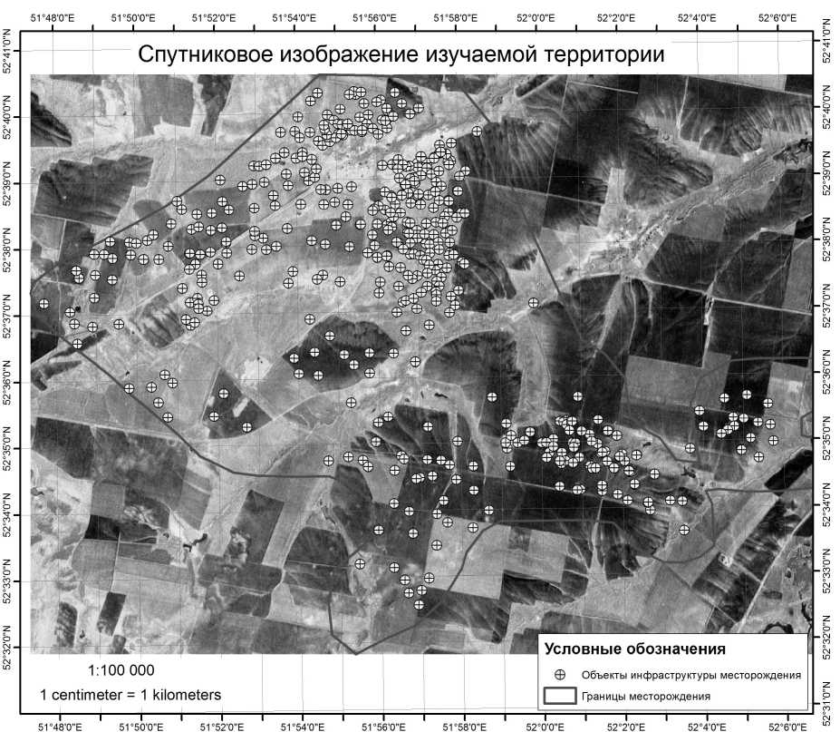
Рис.1. Объекты инфраструктуры Бобровского нефтяного месторождения, выделенные в процессе ручной оцифровки.
Верификация вычислений производилась по векторному слою, содержащему 462 объекта инфраструктуры Бобровского нефтяного месторождения (рис. 1), который был получен ручной оцифровкой данных Landsat и Google Earth.
Основную часть объектов инфраструктуры месторождения составляют площадки нефтедобывающих скважин (более 250), а также площадки разведочных, нагнетательных и законсервированных скважин, факельных установок, технологических объектов Цеха добычи нефти и газа и пр.
Для расчета индексов по указанной сцене Landsat применялось ПО Exelis ENVI 4.8. С помощью ArcGIS 10.1 каждому объекту были присвоены значения соответствующих пикселов из результирующих изображений рассчитанных индексов. Для полученных массивов значений каждого индекса рассчитаны медиана, верхняя и нижняя квартили. Значения последних послужили границами значимых диапазонов внутри каждого изучаемого индекса. Диапазон, определенный статистическими методами, был затем выделен из общего растра каждого индекса и переведен в векторную форму для анализа в ArcGIS.
РЕЗУЛЬТАТЫ И ОБСУЖДЕНИЕ
Значимые диапазоны значений индексов, полученные в результате статистической обработки исходных массивов данных, показаны в табл. 1.
На основании выделенных диапазонов были построены карты распределения значений индексов на изучаемой территории и проведена оценка точности распознавания объектов нефтяной инфраструктуры.
Результаты сравнения индексов BSI, LDI-NDVI и LDI-TCW показывают разную точность распознавания объектов нефтяной инфраструктуры (табл. 2).
Таблица 1. Границы значимых диапазонов спектральных индексов.
|
Индекс |
Нижняя квартиль |
Медиана |
Верхняя квартиль |
|
BSI |
-0.489829 |
-0.462762 |
-0.415030 |
|
LDI NDVI |
0.0673369 |
0.067983 |
0.070000 |
|
LDI TCW |
-0.047349 |
-0.046922 |
-0.046409 |
Таблица 2. Процент совпадений объектов инфраструктуры и территорий, выделенных индексами.
|
Количество скважин внутри значимого диапазона индекса |
Доля совпадения, в % |
|
|
BSI |
308 |
66,66666667 |
|
LDI NDVI |
242 |
52,38095238 |
|
LDI TCW |
229 |
49,56709957 |
|
Всего скважин |
462 |
Относительно невысокая точность распознавания связана, по нашему мнению, в первую очередь с активным сельскохозяйственным использованием земель на территории месторождения. Как видно на рисунке 2, значительная часть скважин находится внутри площадей сельскохозяйственных посевов. Стоит также учитывать тот факт, что значительная часть объектов имеет небольшие размеры (100-200 кв.м.), поэтому даже их визуальное распознавание на спутниковых снимках среднего разрешения (Landsat – пространственное разрешение 30 метров) не является абсолютно достоверным. Такое пространственное разрешение обеспечивает точность данных Landsat в масштабе до 1:200 000. Исходя из этих соображений, процент совпадения результатов BSI и данных контрольного слоя (67%) можно считать удовлетворительным для поставленной задачи.
Наличие полей, которые подвергаются сезонной обработке (распашка, боронение, парование, химическая обработка сорняков) приводит к тому, что доля обнаженных земель, спектральный ответ которых аналогичен таковому промышленных территорий, значительно возрастает и вносит ощутимую путаницу в распознавание объектов антропогенной инфраструктуры. При использовании сходных методов обработки спутниковой информации в условиях, например, тундры, растительный покров которой отличается равномерностью, стабильностью и высокой степенью уязвимости (медленное возобновление после механического повреждения) была достигнута весьма высокая степень точности дешифрирования промышленных объектов [1]. На рисунке 3 показан результат совмещения слоя оцифрованных объектов с результатами распознавания по наиболее информативному индексу – BSI. Хорошо видно, что существенная часть значимого диапазона индекса приходится именно на поля, лишенные растительного покрова, что обуславливает смешивание значений условных классов «объект нефтепромысла» и «пашня».
Перспективными для изучения их свойств на данной территории могут оказаться такие методы, как TopSoil Grain Size Index (GSI) [12] и транс- формация Tasseled Cap [7, 3]. Индекс GSI нашел широкое применение в исследованиях, связанных с проблемами опустынивания и деградации земель [9, 8]. Tasseled Cap Transformation (TCT) была разработана как мультивариативный статистический метод для конвертации спутникового изображения в изображение, содержащее три глав- ных компонента, подчеркивающих классы следующих физических признаков:
-
- яркость, измерение почвы - канал 1,
-
- зеленость, измерение растительности - канал
-
2,
-
- влажность, взаимосвязь почвенной и растительной влажности - канал 3.
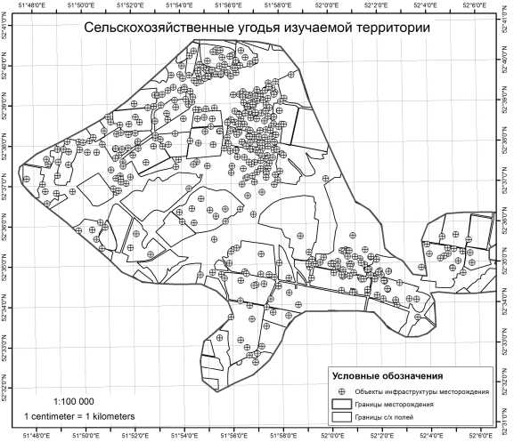
Рис. 2. Границы сельскохозяйственных угодий на территории Бобровского нефтяного месторождения
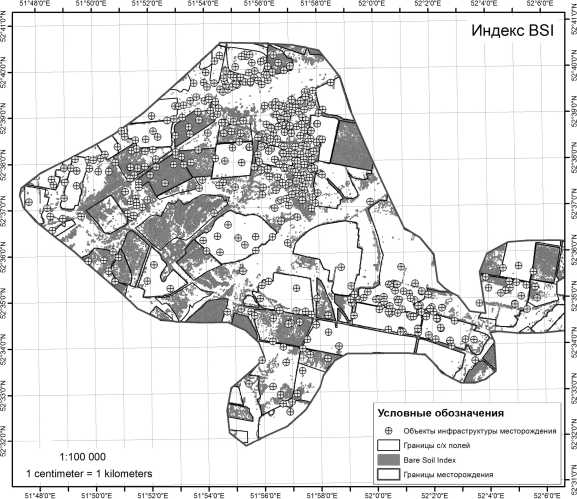
Рис. 3. Распределение значимых диапазонов индекса BSI в границах месторождения Коэффициенты TCT применяются в самом широком спектре задач, решаемых с помощью данных ДЗЗ: от распознавания береговой линии водоемов, до определения нарушений лесов [6,
-
11, 5].
Преимущество метода BandRatio перед другими видами классификации (классификация без обучения, классификация с обучением, эксперт- ное дешифрирование) состоит в том, что однажды полученный и проверенный диапазон значений того или иного индекса может применяться по умолчанию на сходных территориях (или на той же территории, но для другого периода времени). Исследователь будет избавлен от затрат времени на интерпретацию снимка, которую иначе он вынужден проводить для каждой новой сцены прак- тически с самого начала. Этот фактор – снижение трудозатрат на дешифрирование с сохранением высокой точности обработки информации - делает данный метод очень привлекательным и перспективным для дальнейшей разработки.
С целью повышения точности распознавания объектов нефтяной инфраструктуры техногенных ландшафтов представляется целесообразным вывести из расчетов площади, занятые сельскохозяйственными землями. Для этого авторы планируют провести анализ многолетней серии спутниковых изображений представленной территории, с тем, чтобы, сочетая вегетационные индексы с индексами деградации, получить точную маску сельскохозяйственных угодий. Применение указанной маски будет соответствовать поставленной задаче выведения площадей полей из расчетов. Второй задачей планируемых исследований является детальное изучение значимых диапазонов индексов отношений спектральных яркостей для их более подробной классификации, например, до уровня: объекты инфраструктуры месторождения, населенные пункты, естественные пустоши, пашни и пр.
Список литературы Опыт применения данных дистанционного зондирования среднего пространственного разрешения для выделения объектов нефтепромыслов в условиях техногенно-модифицированного ландшафта (на примере Оренбургской области)
- Елсаков В.В., Щанов В.М. Дистанционный мониторинг разновременных нарушений растительного покрова в районах добычи и транспортировки нефти//Современные проблемы дистанционного зондирования Земли из космоса. 2004. № 1. С. 152-155.
- Чибилёв А.А. Энциклопедия «Оренбуржье». Том 1. Природа. Калуга: Золотая аллея, 2000. 192 с.
- Crist E.P. and Cicone R.C. A physically-based transformation of Thematic Mapper data -the TM Tasseled Cap//IEEE Trans. on Geosciences and Remote Sensing. 1984. GE-22. P. 256-263.
- Fadhil A.M. Land Degradation Detection Using Geo-Information Technology for Some Sites in Iraq//Journ. Al-Nahrain Univ. 2009.12 (3). P. 94-108.
- Healey S.P., Cohen W.B., Zhiqiang Y., Krankina O.N. Comparison of Tasseled Cap -based Landsat data structures for use in forest disturbance detection//Remote Sensing of Environment. 2005. 97. P. 301-310.
- Huang C., Wylie B., Yang L., Homer C., Zylstra G. Derivation of Tasseled Cap Transformation based on Landsat & at-satellite reflectance//USGS technical report. 2002. Raytheon ITSS, USGS EROS Data Center Sioux Falls, SD 57198, USA, 10 p.
- Kauth R.J., Thomas G.S. 1976. The Tasseled Cap -A Graphic Description of the Spectral-Temporal Development of Agricultural Crops as Seen by Landsat. LARS Symposia. P. 59. [Электронный ресурс]. Режим доступа: http://docs.lib.purdue.edu/lars_symp/159.
- Marchetti A., Piccini C., Francaviglia R., Santucci S., Chiuchiarelli I. Estimating Soil Organic Matter Content by Regression Kriging. In: Digital Soil Mapping (J.L. Boettinger et al., Eds). Progress in Soil Science 2, Chapter 20. Springer Sceince + Business Media. 2010. P. 241-254.
- Pretorius, D.J., and Bezuidenhout, C.J. Report on the development of a methodology to determine the nature, rate and extent of soil erosion in South Africa//A report in fulfillment of contract no. 14/8/1-L1 for the Department of Agriculture, Directorate Resource Conservation, ISCW Report No. GW1A/94/7, Government Press, Pretoria. 1994.
- Rouse J. W., Haas R.H., Schell J.A., and Deering D. W. Monitoring vegetation systems in the Great Plains with ERTS//Third ERTS Symposium, NASA SP-351 I, 1973. P. 309-317.
- Scott J.W., Moore L.R., Harris W.M., Reed M.D. Using the Landsat 7 Enhanced Thematic Mapper Tasseled Cap Transformation to Extract Shoreline//USGS Open-File Report OF 03-272. 2003. [Электронный ресурс]. Режим доступа: http://pubs.er.usgs.gov/publication/ofr2003272.
- Xiao J, Y., Shen, Y.J., Tateishi R. Development of topsoil grain size index for monitoring desertification in arid land using remote sensing//International Journal of remote sensing, (conditional accept). 2005. [Электронный ресурс]. Режим доступа: http://www.tandfonline.com/doi/abs/10.1080/01431160600554363#.UgPaST8vkow.
- Wentzel K. Determination of the overall soil erosion potential in the Nsikazi District (Mpumalanga Province, South Africa) using remote sensing and GIS//Canadian Journal of Remote Sensing. 2002. 28(2). P. 322-327.
