Pasture degradation evaluation study in the Middle Gobi (Mongolia)
")
Author: Myagmartseren P., Bazarkhand Ts., Ganpurev D., Myagmarjav I., Gantulga G., Bolormaa B., Dorligjav D.
Journal: Природа Внутренней Азии @nature-inner-asia
Section: Монголия
Article in issue: 2 (7), 2018.
Free access
In view of the increased load on rangeland of the Middle Gobi, their condition significantly deteriorated. The purpose of our work is to assess the impact of overgrazing on the territory of Adaatsag district and verification of the methodology for its studying in the arid steppe zone. We have used three types of methods for assessing and comparing the effects of overgrazing. The method for assessing the degradation of ecosystems in Mongolia was developed by Soviet-Mongolian specialists [Gunin et al., 1989]. The method of indicating the state of soils was used in the USA for monitoring of pastures [Pellant et al., 2000]. Methods of control over land use and introduction of state certification were introduced by the Administration of Land Affairs, Geodesy and Cartography of Mongolia (1995). The total area of degraded lands is 72,695 hectares (total pasture area - 329,130 hectares). In comparison with the data of the research carried out in 1992 by the Administration of Land Affairs, Geodesy and Cartography of Mongolia, the areas of pasture degradation increased by 37.5%. The main reason for the degradation of pastures is an extraordinary year- round use. In addition, it is necessary to pay attention to the climatic conditions: a severe drought has aggravated the condition of pasture lands over the past few years.
Overgrazing, rangeland condition and quality assessment, pasture use condition control and monitoring of mongolia
Short address: https://sciup.org/148318004
IDR: 148318004 | UDC: 633.2/.3(517.3) | DOI: 10.18101/2542-0623-2018-2-67-74
Оценка деградации пастбищ в Среднем Гоби (Монголия)
В связи с увеличением нагрузки на пастбища в Среднем Гоби их состояние значительно ухудшилось. Целью нашей работы является оценка воздействия чрезмерного выпаса на территории сомона Адаацаг (Адаацаг сум) Среднегобийского аймака (Дундговь аймак) и проверка методологии его изучения в засушливой степной зоне. Было использовано три вида методов оценки и сравнения воздействия чрезмерного выпаса. Метод оценки деградации экосистем в Монголии был разработан еще советско-монгольскими специалистами [Gunin et al., 1989]. Метод индикации состояния почв использовался в мониторинге пастбищ США [Pellant et al., 2000]. Методы контроля за землепользованием и введение государственной сертификации приняты Главным управлением земельных отношений, геодезии и картографии Монголии (1995). Общая площадь деградированных земель составляет 72 695 гектаров (из 329 130 га общей площади пастбищ). По сравнению с данными исследований, проведенных в 1992 г. Главным управлением земельных отношений, геодезии и картографии, площади деградации пастбищ увеличились на 37,5%. Основной причиной деградации пастбищ является внеочередное круглогодичное использование. Кроме того, необходимо обратить внимание на климатические условия - за последние несколько лет жесткая засуха усугубила состояние пастбищных угодий.
Text of the scientific article Pasture degradation evaluation study in the Middle Gobi (Mongolia)
Stocking rate is increasing in the central part of Mongolia in every year. As a land management researcher, it is very important to know in which condition was rangeland before and after usage of herders and to know how to do conservation and protection of natural resources. The study and rangeland overgrazing assessment was done by method of the Administration of Land Affairs Geodesy and Cartography (ALAGaC) and Middle Gobi province Land office (2000) reported in the work «Middle Gobi province pasture use condition control and state certification» and presented paper is part of this study.
In the Mongolian land law (1994) it is stated:
« The State must regularly control negative land usages and avoid negative influence to the population. State land authority must organize «land use condition control and state certification (monitoring)» activity in all kinds of land use in the territory of Mongolia » (Chapter 6).
Due to this activity, it is very important to monitor pasture and assess degradation of rangeland and test new methodologies in the pilot area and develop the monitoring activities for the common purpose. As the biggest land resource, for the pasture (87 % of all territory), we need to study overgrazing process and get an assessment method which is commonly acceptable and easy to use in the field and enough accurate for national land information database.
We have chosen Middle Gobi province where is the closest Gobi region to the capital city. Since it is closer to the capital city, Middle Gobi province is the most influenced one in overgrazing process. The main factors of overgrazing are the concentration of animal husbandry in small areas and bad weather conditions. The Study area is Adaatsag district where is situated in the north part of the Gobi region and south territory of the Mongolian steppe. Distance from Ulaanbaatar city is 280 km (Fig. 1).
The goal of our work was to assess overgrazing impact in chosen territory and test which methodology is suitable in the arid steppe natural zone. We used three kinds of methods for overgrazing impact assessment. The first was Soviet-Mongolian scientists developed method for ecosystem degradation evaluation in Mongolia [Gunin et al., 1989]. The method is based on several vegetation indicators such as biomass, association structure change, canopy cover, height, bio-indicator plants etc.
The Second was rangeland health monitor’s soil stability indicator method [Pellant et al., 2000]. American High Mountain rangeland monitoring is including 17 indicators and has a too detailed worksheet and procedure. Therefore, we chose only soil stability indicators, which are not clearly included in the Soviet-Mongolian method.
The last one was land use condition control and state certification introduction method [ALAGaC, 1995]. In this paper’s content, more attention is paid to the erosion identification and levelling in different types of land. Pasture overgrazing impact assessment is unclear in this methodological instruction.
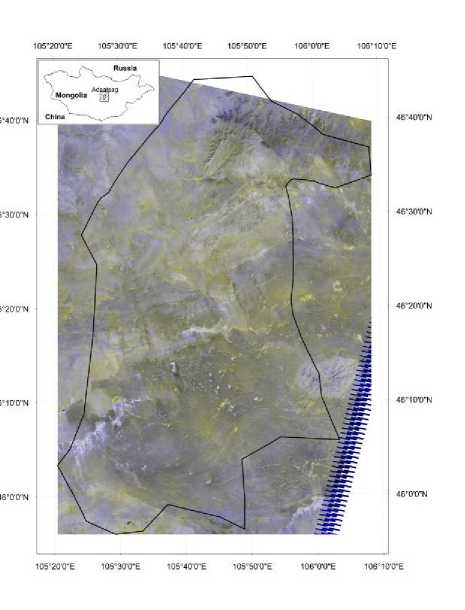
Figure 1. Study area location
Many scientific and practice works exist about overgrazing process and assessment study such as biology, botany, ecology, animal husbandry, geography, sociology, etc. The literature most similar to our work was presented below.
The Soviet-Mongolian biological scientists (Gunin et al., 1989) were developed ecosystem’s degradation assessment in Mongolia. Their study concluded that overgrazing and pasture degradation process could be identified by three kinds of indicators.
– Vegetation biomass: — yield in dry matter and it’s dynamic in the certain time period.
– Vegetation’s association structure and change: — canopy cover, plant height reduce, raise, invading plant species
– Soil erosion process
Pasture vegetation change influenced by grazing activity is changing the ecological group of plant’s growths in the vegetation association [Chognii, 1975].
When stocking rate is out of limit number and canopy cover of mesophyte plants are less than xerophyte plant’s pasture degradation process could clear indicated.
The previous survey had been shown, it is not necessary to have low biomass production in the overgrazed pasture [Jigjidsuren and Purevtseren, 1998]. Sometimes animals are decreasing forage plants and invader plants are growing instead on their places. Invader plants have high biomass but are not so useful for animal fodder. But ecological consequences of these plants still not studied. Therefore, we can’t use only bi- omass as a degradation indicator. One controversial question is an identification of natural climax and degradation change.
In the study of the Soviet-Mongolian complex biological expedition, [Rachkovskay et al., 1995] listed indicator plants which are identifying overgrazing and not aggressively growing in natural climax period.
To assess the rangeland condition, it is very important to know the soil stability. Soil stability is meaning the capacity of the site to limit redistribution and loss of soil by wind and water [Pellant et al., 2000]. We used the earlier mentioned the Soviet-Mongolian methods and USA soil stability indicators to make complex and acceptable new method out of the old for land officers working in the local area. A literature overview showing single indicator assessments can’t assess degradation process and determine the whole complex rangeland condition. Therefore, we are recommending the use of both vegetation and soil stability indicators.
Methods
The study was made in two steps.
-
1. To identify vegetation type and pasture carrying capacity of the evaluation area. We used instruction of ALAGaC for the land survey [ALAGaC, 1995] and vegetation mapping.
-
2. To visit reference areas to observe and test indicators on chosen areas. For assessment of overgrazing we used the following indicators:
– Vegetation general canopy cover, dominant species canopy cover, invader plants canopy cover percent presented in 1 m2 surface. A height of plants in cm.
– Plant biomass production. Yield in dry matter kilograms per ha.
– Vegetation association structure. Invader, decreaser, increaser member plants in the association.
– Bio-indicator of overgrazing. Plants determining pasture degradation. We found 27 plant species growing aggressively in the degraded places.
– Soil stability indicators and evaluating score. We used standard American methodology [Pellant et al., 2000].
Results
In the vegetation mapping, we made 43,6 km long distance transect profile for a ge-obotanical study. The transect beginning from North West point to south-east point of district boundary along to the territory. Adaatsag district vegetation type are hilly steppe in the north area covered by Caragana (Lam.) microphilla — Stipa (L.) glare-osa associations (50,8 % of all area), south territory covered Cleistogenes (Keng.) squerrosa) — Stipa glaereosa (L.) (needle grass) associations (44,2 % of all area). By classification of Mongolian ecosystem [Karamysheva, 1981] the territory of Adaatsag district is arid steppe ecosystem. The vegetation types which were investigated in our study also verifying this classification. All plants are real «identifications» of the arid steppe.
Livestock capita information has been collected from statistical offices of the district and transect investigation’s used pasture yield. Carrying capacity of pasture counted by formula was described by G. Purevtseren [Purevtseren, 2000]. The overgrazed land is 72 695 hectares of total area (329 130 ha.). Compared with an ALAGaC study made in 1992 overgrazed pasture has increased by 37, 5 %. In Adaatsag district normal stocking rate is 40 sheep unit per capita kept in 100 ha. By our study, today’s stocking rate is 56 sheep unit per capita in 100 ha. The main reason of pasture degradation is out of limit usage of carrying capacity. We also need to pay attention to the weather condition.
The weather information [District Meteorological Centre, 2016] shows that temperature is warming from 1992 to 2016 by 1,8 °C degrees above average 30 years’ temperature. Last years had severe drought and influenced to rangeland condition. Especially, yield was very poor compared with previous 1992’s study (Fig. 2).
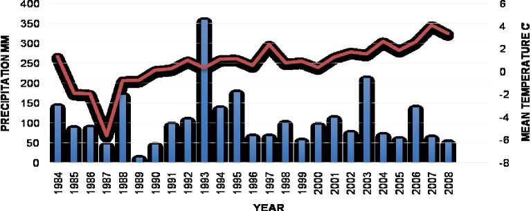
Figure 2. Climadiagram of Adaatsag, Middle Gobi district
From reference areas, we present the most common Caragana microphylla (Lam.) — Stipa glareosa (L.) degraded pasture assessment result (table 1) which is compared with earlier studies made in 1962, 1992.
Table 1 Assessment in Caragana — Stipa degraded pasture
|
Year Indicator |
1962 |
1992 |
2016 |
|
|
Average year’s yield in dry matter (100 kilograms / ha) |
390 |
190 |
110 |
|
|
Canopy cover (%) |
Total |
52 |
40 |
20 |
|
Grasses |
20 |
19 |
7 |
|
|
Shrubs |
25 |
15 |
10 |
|
|
Height of plant (cm) |
Grasses |
25 |
15 |
10 |
|
Shrubs |
50 |
40 |
25 |
|
|
Number of species in 100 m2 |
14 |
10 |
11 |
|
When comparing three years result it is clear that Adaatsag district pasture condition is getting more unsuitable for animal husbandry grazing. The earliest study [Yuna-tov, 1942] stated caragana — stipa pasture has 300-400 kg/ha average year yield. By 1962 land survey expedition this reference area’s yield was 390 kg/ha. In 1992 the Administration on Land Affairs Geodesy and Cartography made a pasture mapping in this area and described there’s 190 kg/ha yield. Our study in 2016 shows the yield is 110 kg/ha. Yield decreased since 1962 three times. From 1992 to 2016 canopy cover got 2 times slighter. Grass plants canopy cover changed by 12 percent. Instead of Stipa glareosa and Agropyron cristatum (crested wheatgrass) species, there are dominating overgrazing indicator plants such as Artemisia adamsii, Salsola collina (slender thistle), Chenopodium album (lamb's quarters) etc. Soil stability score was 2. It means the soil is endangered to get eroded.
Discussion
We need more detailed research to identify which factor most influence pasture degradation. In our study, we can’t say if the limit of carrying capacity or climate warming and multi-years’ summer drought is most influencing. To make a detailed study we need a control data of protected area which is not under grazing during long a time period. Also, we need long duration monitoring to be verifying factors’ size and impact. Soil stability research was made only in 2016. Earlier studies did not include soil study. Therefore, we can’t compare soil character which was very important in our study. In our view, soil character is more constant during weather change than vegetation indicators. We recommend using both vegetation and soil stability indicators for arid steppe rangeland. The result of reference data of area show big differences between 1962, 1992 and 2016. Without detailed result, there is unclear reasons for vegetation indicator changes. Another complicated problem is how to regulate carrying capacity of pasture. We can say in some way, depending on the number of animals, pasture degradation could be bigger or smaller. Therefore, we need a study of animal capita number and degradation level in statistically significant number of several areas.
Conclusions
-
1. Adaatsag district vegetation type presents hilly steppe in the north area covered by Caragana (Lam.) — Stipa (L.) associations (50,8 % of all area), south territory covered Cleistogenes (Keng.) — Stipa (L.) associations (44,2 % of all area). Both types are arid steppe vegetation types. We can directly say this territory is in the arid steppe zone by vegetation type.
-
2. The overgrazed land is 72 695 hectares of total area (329 130 ha). Compared with the ALAGaC study made in 1992 overgrazed pasture increased by 37, 5 %.
-
3. In Adaatsag district normal stocking rate is 40 capita sheep unit in 100 ha. By our study, today’s stocking rate is 56 sheep unit per capita in 100 ha. One of the reasons of pasture degradation is out of limit usage of carrying capacity.
-
4. We also need to pay attention to weather condition. Last years had a hard drought that influenced the rangeland conditions. In 8 years temperatures are 1,8 °C degrees higher than average 30 years temperature.
-
5. When comparing with reference areas 1962, 1992, 2016 years’ results Adaatsag district pasture condition is getting more unsuitable for animal husbandry grazing. In the future, we need to do a detailed study that could distinguish weather and husbandry factors to the pasture conditions.
References Pasture degradation evaluation study in the Middle Gobi (Mongolia)
- Gunin P. D., Vostokova E. A. and Druke A. Y. Methodological Recommendation for Ecosystem Degradation Assessment. Leningrad, 1989. Pp. 118-128.
- Pellant M., Shaver P., Pyke D. A. and Herrick. J. E. Interpreting Indicators of Rangeland Health / USDI: Bureau of Land Management. Denver, 2000. V. 3. Technical Reference. Pp. 1734-6.
- Administration of Land Affairs Geodesy and Cartography and Institute of Geo-Ecology. Land Use Condition Control and State Certification Introduction Method. Ulaanbaatar, 1995.
- Myagmartseren P., Jigjidsuren S. Report of Middle Gobi province pasture mapping. Administration of Land Affairs Geodesy and Cartography. Ulaanbaatar, 2000.
- Mongolian Parliament. Mongolian Land Law. Ulaanbaatar, 1994. Chapter 6.
