Портуланы - морские карты XIV-XVI вв.

Автор: Щетников Андрей Иванович
Журнал: Schole. Философское антиковедение и классическая традиция @classics-nsu-schole
Рубрика: География
Статья в выпуске: 1 т.9, 2015 года.
Бесплатный доступ
В обзоре рассмотрена история ранних европейских морских карт (портуланов) средиземноморского региона и прилегающих территорий на побережье Атлантики. Обсуждается техника их изначального исполнения, последующего уточнения и копирования и делается вывод о том, что первым центром систематического изготовления карт Средиземноморья была Генуя
География в античности в средние века, картография, путешествия
Короткий адрес: https://sciup.org/147103406
IDR: 147103406
Portolans - the sea charts from the fourteenth to fifteenth centuries
The survey is devoted to the history of European portolan sea charts, mapping the Mediterranean and adjusting Atlantic coasts. I discuss the techniques of their initial charting and subsequent refinement and coping and conclude that the first center for systematic mapping of the Mediterranean was Genoa.
Текст научной статьи Портуланы - морские карты XIV-XVI вв.
Предуведомление. Работая над этим обзором, я одновременно правил (а по сути дела, писал заново) статью «Портуланы» в русской Википедии. Поэтому тексты обзора и статьи в значительной степени повторяют друг друга. Последняя часть обзора, посвящённая проблеме возникновения портуланов, написана относительно недавно, и в Википедии её нет.
Что такое портулан?
Классический портулан эпохи позднего Средневековья и Возрождения, от конца XIII до XVI века – это морская карта, на которой показана акватория Средиземного и Чёрного морей, а также побережье Атлантического океана за Гибралтаром: на север – от Пиренейского полуострова до Фландрии, включая южные берега Британии и Ирландии; на юг – марокканский берег с Канарскими островами.
ΣΧΟΛΗ Vol. 9. 1 (2015)
Эта карта скопирована в конце XVI века с ещё одной, которую нарисовал в 1521 году для своей Книги морей турецкий адмирал и картограф Пири-реис. От стандартного портулана она отличается только отсутствием подписей. Обратите внимание на рисунки Марселя, Генуи, Венеции и Каира.
Следует отметить, что слово portolano в итальянском языке обозначало не карту, а словесный текст, описывающий морское побережье при плавании вдоль него – то, что в античности называлось «перипл». Таким портуланом, к примеру, является составленная в середине XIII века анонимная итальянская лоция Il compasso da navigare (см. Motzo 1947). Изготовители карт называли свои изделия не портуланами, но carta nautica – «морскими картами».
Портулан как первая точная карта
Основная черта портуланов, которая сразу же бросается в глаза всякому, кто привык иметь дело с географическими картами – это их высокая топографическая точность. Очертания морских берегов на портуланах достаточно близки к очертаниям этих же морей на современных картах, чего нельзя сказать о других картах Европы, изготовленных в эту же самую эпоху в рамках другой картографической традиции.
Условные обозначения и генерализация
Будучи морской картой, портулан составлялся в первую очередь для нужд морской навигации. Для удобства пользования мелкие детали побережья изображены на нём достаточно условно. Острова, чтобы их было лучше видно, выделяются разными цветами. Небольшие мысы зачастую показываются за- метно крупнее, чем они есть на самом деле. Бухты между мысами могут схематично изображаться дугами окружностей. Эстуарии рек обозначены двумя параллельными линиями, входящими в глубь суши. Прибрежные скалы изображены чёрными точками, мели – красными точками.
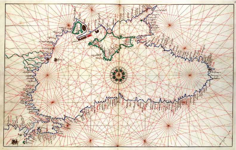
Портулан Чёрного моря из атласа Батисты Аньезе (1553).
Подписи деталей береговой линии
Вдоль побережий подписаны многие сотни географических объектов – мысы, заливы, реки, порты. На большом портулане Средиземноморья может быть сделано несколько тысяч таких подписей. Все подписи направлены от берега внутрь суши. Поэтому у портулана нет выделенной ориентации подписей, как у современной карты, и его одинаково удобно рассматривать с разных сторон.
Итальянский и каталанский стили изображения
Основные мастерские по изготовлению портуланов находились в центрах средиземноморской морской торговли: Генуе, Венеции и Ла Пальме. В соответствии с местом изготовления различают портуланы двух типов, которые условно принято называть итальянским и каталанским.
На итальянском портулане внутренняя территория суши не показывается совсем – здесь проведена только береговая линия и сделаны подписи к ней. На каталанском портулане имеются изображения некоторых горных хребтов, рек и других внутренних географических объектов, а также разные дополнительные художества, удовлетворяющие любознательность, но не нужные для мо- реплавания. При этом географические объекты суши нарисованы здесь крайне схематично, без соблюдения пропорций и масштаба.
Геодезия портуланов
Сетка румбов
Характерной чертой портуланов, создающей неповторимый образ «старинной морской карты», является нанесённая на них сетка румбов. Как правило, эта сетка строилась для шестнадцати основных направлений. Для её построения проводится большая вспомогательная окружность, охватывающая заметную часть карты. В этой окружности строятся два перпендикулярных диаметра в направлениях «север – юг» и «запад – восток». Между ними делением дуг окружности пополам проводятся новые диаметры так, чтобы в итоге вспомогательная окружность была пересечена диаметрами в шестнадцати равноотстоящих точках. Все пары точек соединяются прямыми линиями определённых цветов: чёрные линии для четырёх основных направлений, зелёные – для следующих четырёх, красные – для следующих восьми. Большие портуланы, охватывающие всё Средиземноморье, могут быть снабжены сеткой румбов, построенной на основе не одной, но двух касающихся окружностей равного диаметра.
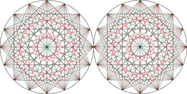
Сетка румбов на основе двух касающихся окружностей.
Использование компаса
Направление «север – юг» на портуланах систематически отклоняется от истинного географического меридиана на величину от 4° до 12°, разную для разных больших частей Средиземного моря. Естественно считать, что это направление соответствует магнитным меридианам с характерным для данной эпохи магнитным склонением.
Капитаны кораблей в открытом море ориентировали свои карты по стрелке компаса, а не по небесным явлениям, указывающим на географические север и юг. Надо полагать, что и составители портуланов пользовались в своей работе магнитным компасом с картушкой румбов, который к концу XIII века был уже известен (см. Lane 1963).
Масштаб
Многие портуланы снабжены масштабными линейками. Каждое большое деление линейки делится точками на 5 малых делений. В современных мерах большое деление составляет – 60±5 км, малое деление – 12±1 км. Принято считать, что такое малое деление на карте равно 10 милям на местности, где одна миля равна 1,2±0,1 км.
Картографическая проекция
Все линии постоянного курса, называемые также локсодромиями, изображаются на плоскости прямыми линиями единственно в проекции Меркатора. Если бы портуланы осознанно строились в определённой картографической проекции, это была бы проекция Меркатора.
Однако первые авторы портуланов, жившие в XIII веке, вряд ли руководствовались в своей работе такими абстрактными математическими принципами. Поскольку работа по составлению карт почти наверняка велась с разбиением всей средиземноморской акватории на отдельные бассейны, для каждого бассейна отклонение формы земной поверхности от плоскости было не слишком большим, и линии одного магнитного направления в этих пределах можно было считать параллельными. Когда карты отдельных бассейнов сшивались в одну общую карту, неизбежно возникали некоторые неувязки, но из-за общей вытянутости Средиземноморья в широтном направлении они были не слишком велики (анализ возникавших при этом искажений см., например, в работе Gaspar 2010). Итоговая карта в пределах Средиземноморья должна была получиться похожей на карту в проекции Меркатора.
Заметные проблемы должны были возникнуть при соединении больших пространств в меридиональном направлении, но такими пространствами для портулана были только Бискайский залив и Британские острова. При этом линия, соединяющая какие-нибудь две точки в Британии и Италии, должна была сильно исказиться как в линейном масштабе, так и по направлению; однако эта линия шла по суше и поэтому в морских делах никого не интересовала.
Портуланы в их документированной истории
Портулан как массовая продукция
До наших дней сохранилось около трёх десятков портуланов XIV века и примерно полторы сотни портуланов XV века (см. Campbell 1986); ясно, что в реальности они изготавливались тысячами. Карты Средиземноморья, относящиеся к этому же типу, продолжали ещё более массово производиться и в XVI веке, уже после открытия Нового Света и пути в Индию вокруг Африки.
Массовое производство карт и достаточно большое время, требуемое для тщательной перерисовки одной карты, привели к тому, что изготовление карт стало отдельной профессией, которой занимались в специализированных мастерских.
Для изготовления портулана обычно брался качественный пергамент из овечьей шкуры, очень часто – с необрезанной до прямоугольника шейной частью. Типичный лист такого пергамента имел размеры около 100 × 60 см, иногда несколько меньше, иногда больше. Два или даже четыре прямоугольных листа пергамента могли соединяться вместе для получения более крупной карты.
Для того, чтобы перенести береговую линию с исходного оригинала на новый лист в масштабе один к одному, нужно было сначала приготовить первую копию на прозрачной кальке. Затем, используя закопчённую копировальную бумагу, эта линия переносилась с кальки на чистый пергамент (см. Pujades 2007, p. 472).
Пизанская карта
Самый первый портулан, сохранившийся до наших дней – это Пизанская карта, датируемая концом XIII века. Она называется так, потому что долгое время хранилась в Пизе; а в качестве возможного места её изготовления, кроме Пизы, рассматривались также Венеция и Генуя.
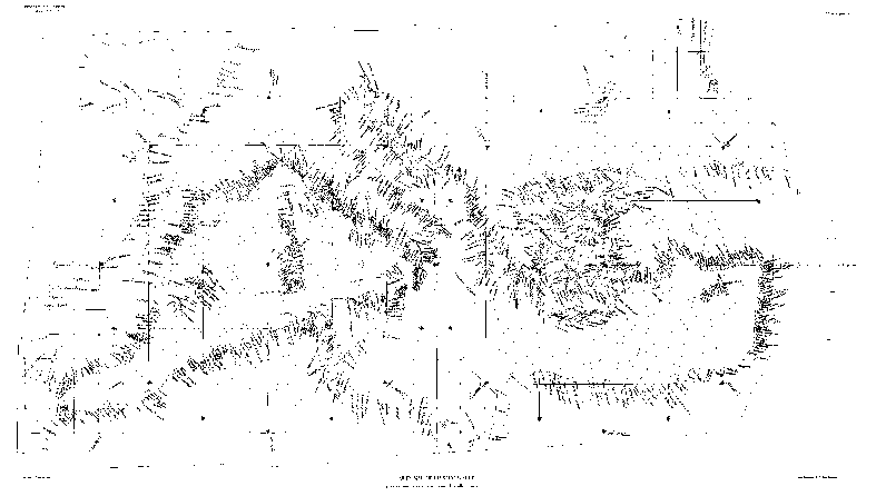
Пизанская карта. Перерисовка XIX в.
Подписанными отметками на этом портулане плотнее всего покрыты побережья Тирренского миря, а также Святой Земли, что соответствует его предполагаемому генуэзскому происхождению. На Пизанской карте изначально была изображена западная часть Чёрного моря (восточная не вписалась в размеры пергамента), но к сожалению, изображение Чёрного моря безнадёжно испорчено.
Пизанская карта ещё заметно отличается во многих деталях от несколько более поздних портуланов первой половины XIV века. Западное Средиземноморье проработано на ней не столь детально, как на последующих картах. Оке- анское побережье Атлантики изображено весьма условно и с совсем немногими деталями. Очертания Бискайского залива и южного берега Англии переданы совсем грубо; при этом Лондон отмечен не на восточном, а на южном берегу острова.
Итальянский «сапог» выглядит заметно более толстым, чем он есть на самом деле. Это понятно: если территория такой формы рисуется с моря, точная пробивка расстояний внутри суши с одной стороны полуострова на другую оказывается весьма затруднительной, и установить ошибку тоже будет весьма трудно.
С очень сильными искажениями и весьма условно изображена береговая линия залива Сидра – при том, что остальное африканское побережье Средиземного миря показано весьма точно и подробно.
Более поздние европейские портуланы
На нескольких картах работы Пьетро Весконте, датируемых 1311–1321 годом, побережье Атлантики вплоть до Фландрии уже показано с той же степенью деталировки, что и Средиземноморье. К этому времени глобальный обмер всех побережий, изображённых на классическом портулане, был уже в основном завершён. Некоторые уточнения делались и позднее для северной части Британских островов.
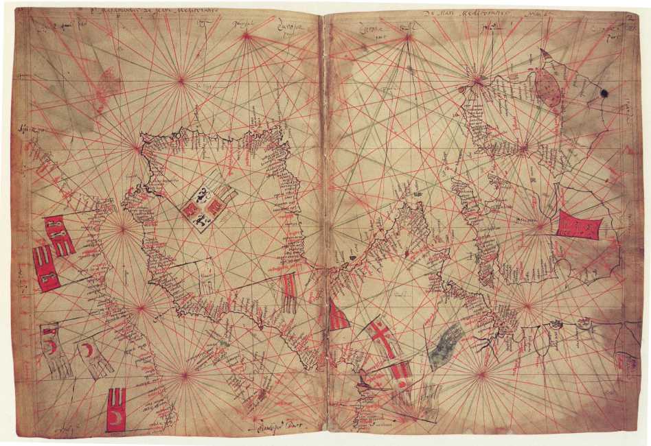
Карта западного Средиземноморья и Атлантики из атласа Пьетро Весконте (1325)
В последующее же время установленные очертания берегов только копируются, на них уточняются названия и флаги владычества, но новых картогра- фических съёмок в регионе уже не производится. При этом многократное копирование приводило лишь к ухудшению воспроизведения мелких деталей карты, практически никак не сказываясь на качестве изображения в целом.
Портуланы в странах ислама
От XIV–XV века, помимо большого числа морских карт, изготовленных в христианских странах Средиземноморья, сохранилось также четыре карты, сделанных в странах арабского Магриба. Самую раннюю из них, так называемую «Магрибскую карту», принято датировать приблизительно 1330 годом. Эта карта, на бумажном листе которой изображено западное Средиземноморье, отличается от современных ей итальянских портуланов подписями, выполненными на магрибском диалекте арабского языка. Две другие карты изготовлены в Тунисе в 1413 году и в Триполи в 1461 году.
Сохранилось также некоторое число более поздних портуланов оттоманского происхождения, включая Книгу морей – лоцию Средиземноморья, составленную адмиралом Пири-реисом в 1521 году.
Проблема возникновения портуланов
Две гипотезы о времени и месте появления «первого портулана»
Мы знаем, что к концу XIII столетия средиземноморский портулан был уже в основном составлен. И мы не имеем ровным счётом никаких свидетельств о том, кто, где, когда и как его составил.
О времени и месте составления первых портуланов имеются две гипотезы. Согласно первой из них, первые портуланы были составлены в конце XIII века, вероятнее всего – в кругу генуэзских купцов, ведущих морскую торговлю. Впрочем, рассматривается и вариант, согласно которому первые портуланы были составлены в это же время, но на Мальорке. Вторая гипотеза – экзотическая; согласно этой гипотезе, морская карта Средиземноморья была составлена ещё в античности, а потом в конце XIII века каким-то образом попала в руки средиземноморских моряков.
Гипотеза об античном происхождении портулана представляется мне крайне сомнительной. Она основывается на единственном утверждении: «европейские моряки XIII века столь сложной и согласованной картографической работы проделать не могли, а вот географам эллинистической эпохи она была вполне по силам».
Однако против античного происхождения портуланов можно привести ряд достаточно весомых доводов. В основе эллинистической картографии, представленной в Географии Птолемея, лежал принцип географической координатной сетки, параллелей и меридианов, широты и долготы. Однако все известные нам портуланы не содержат ничего похожего на сетку широт и долгот. Они всецело опираются на сетку компасных румбов, привязанных не к географическому, но к магнитному меридиану. Античные же мореплаватели и географы магнитного компаса не знали. Было бы очень странно, если бы чудом сохранившаяся античная карта была переведена в XIII веке с координатной сетки широт и долгот на сетку компасных румбов – ведь традиция не допускает такой вольности обращения.
Далее, система определения координат географических пунктов, принятая в Географии Птолемея, позволяет с достаточным правдоподобием взаимного положения наносить на карту точки, отстоящие друг от друга на весьма значительные по географическим меркам расстояния. Во всяком случае, при определении долгот методом одновременного наблюдения лунных затмений ошибке в 4 минуты в определении времени начала затмения соответствует ошибка в 1° по долготе. Система азимутов и румбов, напротив, хорошо работает на относительно небольших расстояниях, и лучше всего – в пределах прямой видимости мысов, вершин и других примечательных географических объектов. И порту-ланы демонстрируют нам именно такую качественную рисовку взаимного положения географических очертаний «в малом».
К этому доводу добавим ещё один. Внимательное сличение разных порту-ланов показывает, что ранние портуланы не копируют друг друга буквально, но постепенно улучшаются, и лишь потом начинается копирование без улучшений. Если в XIV–XV веке европейские мореплаватели и картографы смогли нарисовать карты Бискайского залива, Британских островов и Западной Африки, почему они не могли в XIII веке составить карту Средиземного и Чёрного морей?
Сообщение Раймонда Луллия
Раймонд Луллий (1235–1315), живший на Мальорке, был крупным философом и теологом, христианским миссионером, знатоком многих наук. Он много путешествовал по морю и был до какой-то степени знаком с искусством мореплавания. В разделе De marineria своей книги Arbre de sciencia, написанной на каталанском языке в 1295 году, Луллий описывает способ, которым моряки соотносят расстояние, пройденное кораблём по реальному курсу, с расстоянием, которое он должен был пройти по запланированному курсу (см. Cotter 1978). Этот пассаж заканчивается фразой о том, что «для этого моряки имеют инструмент, карту, иглу компаса и направление на север» (e daço han instrument carta у compass agulla e tremuntana).
Эту фразу иногда приводят как указание на то, что каталанские моряки уже пользовались морскими картами в конце XIII века. Однако, она не является достаточно определённой. Словом carta здесь может быть названа не географическая карта, но геометрическая таблица. Сompass agulla тоже может означать как стрелку компаса, так и циркуль-измеритель. И даже если у моряков с Мальорки имелись в это время карты западного Средиземноморья, составление карты восточного Средиземноморья и тем более Чёрного моря безусловно не было их делом.
Морская торговля в конце XIII века
Поскольку портулан Средиземного моря был к 1300 году уже составлен, самое его составление пришлось на более раннюю эпоху. Обстоятельства, в которых происходила эта работа, нам совершенно неизвестны. Ясно, что на неё ушёл не один год; а может быть, и несколько десятков лет.
Потребность в проведении систематических картографических работ вызывается развитой морской торговлей; как то, так и другое предполагает относительную свободу плавания и относительный мир.
Состояние дел в средиземноморской морской торговле достаточно подробно освещается в статье Lane 1963, посвящённой изобретению морского компаса и началу его использования в навигации. Автор обращает особое внимание на то, что до 1280 года торговые караваны снаряжались Генуей, Пизой и Венецией один раз год, так что плавание велось, как и в античную эпоху, только в летнее время. Однако в конце XIII века происходит переход к снаряжению не одного, а двух караванов в год. Обзоры нотариальных записей Пизы показывают, что зимнее плавание в Средиземноморье начинается в 1280 году. Эти изменения в европейском мореплавании наиболее естественно могут быть связаны как с изобретением компаса, приходящемся на 1270–1300 годы, так и с появлением новых морских карт, приспособленных для использования компаса и для плавания не вдоль побережья, но напрямую через море, со счислением курса.
В этой же статье отмечается, что именно в эту эпоху начинается систематическое плавание торговых кораблей из Средиземноморья напрямую к южным берегам Англии через Бискайский залив. Об этом свидетельствуют это контракты хозяев генуэзских галер 1277 и 1278 гг. А мы знаем, что Бискайский залив и берега Ла-Манша изображены, правда ещё не слишком подробно, уже на Пизанской карте, датируемой 1290 годом. Так что одни концы здесь хорошо сходятся с другими.
Освоение Черноморского бассейна
Посмотрим с этой же точки зрения на то, когда мог быть составлен порту-лан Чёрного и Азовского морей.
Систематическое освоение Чёрного моря генуэзцами началось в 1169 году, когда византийский император Михаил Комнин разрешил генуэзским кораблям проход через Босфор. В 1204 году Константинополь был взят крестоносцами, и проход в Чёрное море для генуэзцев оказался затруднён из-за больших пошлин.
В 1267 году генуэзцы заключили Нимфейский договор с никейским императором Михаилом VIII Палеологом, по которому они обещали императору военно-морскую поддержку в отвоевании Константинополя, а тот даровал им право торговли и основания факторий в Чёрном море и на островах и мало-азийском побережье Эгейского моря. В 1265 году Константинополь вернулся к византийцам, после чего генуэзцы вновь начали активное освоение черномор- ских побережий, основав Кафу на месте нынешней Феодосии в 1266 году и ряд других колоний.
В свете этих фактов вполне правдоподобным представляется предположение о том, что портулан Чёрного и Азовского моря был составлен генуэзцами в конце XIII века – что опять же хорошо согласуется с датировкой Пизанской карты.
Список литературы Портуланы - морские карты XIV-XVI вв.
- Анучин Д. Н. (1915) Старинная морская карта на пергаменте из собрания графа А. С. Уварова. Москва, Типографiя Г. Лисснера и Д. Совко.
- Campbell T. (1987) “Portolan charts from the late thirteenth century to 1500,” Harley J. B. & Woodward D. (eds), The history of cartography, Vol. 1: Cartography in prehistoric, ancient and medieval Europe and the Mediterranean, 370-463. Chicago, University of Chicago Press.
- Clos-Arceduc A. (1956) “L’énigme des portulans: Étude sur la projection et le mode de construction des cartes à rhumbs du XIVe et du XVe siècle,” Bulletin du Comité des Travaux Historiques et Scientifiques: Section de Géographie 69, 215-31.
- Cotter С. H. (1978) Early tabular, graphical and instrumental methods for solving problems of plane sailing. Coimbra, Universidade de Coimbra.
- Gaspar J. A. (2010) From the portolan chart of the Mediterranean to the latitude chart of the Atlantic: Cartometric analysis and modeling. Lisboa, Universidade Nova de Lisboa.
- Kretschmer K. (1909) Die italienischen Portolane des Mittelalters: Ein Beitrag zur Geschichte der Kartographie und Nautik. Berlin; repr. 1962 Hildesheim, Georg Olms.
- Lane F. C. (1963) “The economic meaning of the invention of the compass,” Am. Hist. Rev. 68, 605-617.
- Motzo B. R. (1947) Il compasso da navigare: opera italiano della metà del secolo XIII. Cagliari, Università di Cagliari.
- Nordenskiöld A. E. (1897) Periplus: an essay on the early history of charts and sailing-directions. Trans. F. A. Bather. Stockholm, Norstedt.
- Pujades R. J. (2007) Les cartes portolanes: la representació medieval d'una mar solcada. Barcelona, Lunwerg Editores.
- Soucek S. (1987) “Islamic charting in the Mediterranean,” Harley J. B. & Woodward D. (eds), The history of cartography, Vol. 2(1): Cartography in the traditional Islamic and South Asian societies, 263-292. Chicago, University of Chicago Press.
- Stevenson E. L. (1911) Portolan charts: Their origin and characteristics. New York, Knickerbocker Press. Uhden R. (1935) “Die antiken Grundlagen der mittelalterlichen Seekarten,” Imago Mundi 1, 1-19.
