Preliminary hydraulic study of the Po river in urban area through a steady flow simulation with HEC-RAS software and potential anthropogenic impact of an hydroelectric implant on the landscape

Author: Piazzese G.
Journal: Антропогенная трансформация природной среды @atps-psu
Section: Проблемы городской среды
Article in issue: 2, 2016.
Free access
This report constitutes a preliminary hydraulic study of the river Po in the urban area of Turin, particularly in the section between the confluence with the stream Sangone and the confluence with the river Dora Riparia. The purpose of the study is to model from the point of view of the hydraulic behavior of the river, by making use of geometrical data relating to river sections and hydrological information about Po basin. The analysis has been supported by use of the hydraulic modeling software HEC-RAS (Hydrologic Engineering Center - River Analysis System), a very used software in the application field of hydraulic engineering, which allowed to simulate the behavior of the river in its schemes characteristic of flow rate, and numerically to derive the physical variables that determine the hydraulic phenomena and of transport of matter.
Po river, hec ras, flood, hydroelectric implant, река po, hec-ras (гидрологический инженерный центр)
Short address: https://sciup.org/147226764
IDR: 147226764 | UDC: 502
Text of the scientific article Preliminary hydraulic study of the Po river in urban area through a steady flow simulation with HEC-RAS software and potential anthropogenic impact of an hydroelectric implant on the landscape
The study covers the stretch of the river Po between die confluence with the river Sangone and the Dora Riparia, as shown in the following Figure 1. The river channel is considered a little over 8 km, and takes on the traits of a river valley, with an average gradient which is about if = 0.0007. The river is located at an average altitude of about 215 m sJ.in. and at an altitude that varies from 5 to 15 m below the average share of the urban plan. From die data available to Regional Agency for Environmental Protection of Piedmont (ARPA) and Authority of the Po River Basin (ADBPO) it shows that die river basin underlying the final section considered is approximately 4500 km2.
For the reconstruction of the behavior of die river Po in the urban examined were used 18 river sections provided by the Interregional River Po Agency (AIPO), acquired during a field survey in 2003. Three additional sections have been provided by the Technical the City of Turin, and cover the area of Murazzi. Data from AIPO are geo-referenced, and data from the Municipality of Turin are related only to tire main channel of
® G. Piazzese, 2016
the river, not to mention the banks, which have been rebuilt by means of an architectural relief expeditious, using the municipal Technical Map of adequate scale for the surrender of allowances relative points. Following is shown the location of the sections, with its summary Table 1 related to Figure 1.
Figure 1 - Geographical framework and reconstruction in HEC - RAS tract of river channel in exam
The above 21 sections were included in the hydraulic modeling software НЕС-RAS. which lias allowed us to simulate the behavior of the free surface of the Po for various flow levels. In the stretch of river in question are eight bridges, which were reconstructed both from the information of the Historical Arcliive of the City of Turin, is based on a photographic survey and on the basis of the Technical Map of the City of Turin (scale 1: 1000 ) for a more accurate return of the shares. For insertion of the bridges and the representation of the enlargement of the river at the Ponte Vittorio, tlic software required to generate 14 additional sections, fictitious, therefore tlic total number of sections of calculation is equal to 35. Another exception deserves Section S06DBR. oblique to the direction of motion of the river, along the Crosspiece Michclotti (8.0). detected before the renovations of the same (2007-2008). This section lias been rotated so that you can place the transverse direction to the motion and was modified on the basis of the Plan of Arrangement of the Cross in order to properly understand the work of the dam with the same relative geometry (absent in the official figure).
Table 1
Table identifying sections [4]
|
Official Code |
Name |
Progressive (m) |
HecRAS number |
Officiu! Code |
Name |
Progressive (m) |
HecRAS number |
|
S06I |
Monte Passerella Turin |
0 |
18.0 |
Sez. 43 |
Murazzi 2 |
4610 |
9.2 |
|
S06HA1 |
CTO |
1299 |
17.0 |
S06E |
Monte Ponte Vittorio |
4849 |
9.0 |
|
S06HA |
Sottopasso Units d’Italia |
1677 |
16.0 |
S06DBR |
Traversa Michelotti |
4983 |
8.0 |
|
S06H |
Valle P.te Balbis |
1962 |
15.0 |
S06DA |
Valle trav. Michelotti |
5540 |
7.0 |
|
S06G |
Valle P.te Isabella |
2631 |
14.0 |
S06C |
Monte P.te Regina Margherita |
5934 |
6.0 |
|
S06FB |
Torino Esposizioni |
2811 |
13.0 |
S06CB |
Lungopo Antonelli 1 |
6265 |
5.0 |
|
S06FA |
Castello del Valentino |
3460 |
12.0 |
S06CA1 |
Lungopo Antonelli 2 P.za Chiaves |
6967 |
4.0 |
|
S06F |
Monte P.te Umberto I |
4137 |
11.0 |
S06CA |
Lungopo Antonelli 3 |
7572 |
3.0 |
|
S06EA |
Valle P.te Umberto I |
4206 |
10.0 |
S06C |
Monte P.te Sassi |
7767 |
2.0 |
|
Sez. 41 |
Monte Murazzi |
4311 |
9.5 |
S06BC |
Monte confluenza Dora |
8101 |
1.0 |
|
Sez. 42 |
Murazzi 1 |
4463 |
9.3 |
||||
As regaids tire rating curve, or tire report that in a given section, binds tire value of the water depth with the effluent flow, reference is made to the reports given by tire main texts of hydraulic, using a type
Manning coefficient (riverbed roughness coefficient as — ) in the equation: n
1 2 1 3
Q = A—Дй3 •/ 2 [1] where, Q is flow expressed in [in /s]. A is area of fluvial section [m ], R is hydraulic radius [in] and if is slope of riveibed [%oL By placing the different coefficients of Manning to Concrete (also 271
called Calcestruzzo (Cis) in this report), clean earth (considering middle size of sediments witlrout riverbed forms - called D50), and real conditions with riverbed forms, in software HEC - RAS. have been developed scales outflow for each of the 18 sections available, for a total of 35. Note that since this is a river, whose banks have been almost totally changed to the natural, tire roughness of tire same varies greatly depending on the considered section, and for this reason a case by case from the table of Chow. 1959 e Marchi-Rubatta, 1981. have been taken roughness most suitable in relation to tire reliefs photo made in situ on the banks. Here are the stairs outflow related to riverbed assuming that both concrete (Cis) or in the ground. Subsequently, using the data of grain size obtained in tire Piedmont Region, it shows the scale outflow of the riverbed considering tire actual size of the fund. In tire hypothesis of riverbed in real conditions with forms of background, assuming a coefficient of Manning n variable depending on the section for the banks and for the main river bed equal to 0.153. For Cis instead, always to the same section, it is assumed a coefficient. Manning (1 / n) equal to 60 [2], therefore n = 0.016 [2] and for tire riverbed in real conditions without bed forms a Maiming equal to 0.039 [2] (Figure 2 - Sect. Confluence with Dora).
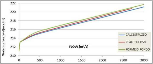
Figure 2 - Rating curve for the river section of Confluence Dora (sect. N.1.0)
In the case of the section in the vicinity of the confluence PO - Dora Riparia, the maximum variation in height of the free surface is 1 tn between tlie case of real riverbed in the absence or in the presence of bed forms. The profile is higher in the second case. In the section downstream hand, are registered variation of the staircase of outflow minimum, the order of centimeters between a roughness and the other and therefore does not significantly relevant. For the stretch of river considered, we were made different Simulations of the free surface at different flow rates. The modeling was made by inserting the geometry of river sections complied, within the software HEC - RAS. The profiles shown below, for the flow rates of 25, 75. 500. 1000. 2700 nr’ / s. were obtained using the coefficients of roughness of the riverbed that are taken as the real ones. Tlie coefficients [2] to Manning are variable 0.02 to 0.05 for (he banks, depending on the section in question, and 0.153 for the main river bed. From Figure 3. it can be observed in sections upstream is established the height of steady flow.
Table 2
Change in share of the free surface as a function of the roughness of the riverbed in relation to Figure 2
|
0[m3/s] |
Concrete |
D50 |
Roughness of riverbed |
|
У [mJ |
У [mJ |
У [mJ |
|
|
0 |
211.120 |
211.120 |
211.120 |
|
25 |
213.051 |
21.3.044 |
213.060 |
|
75 |
213.390 |
213.356 |
213.446 |
|
too |
213.543 |
213.494 |
213.626 |
|
500 |
215.278 |
215.087 |
215.661 |
|
3000 |
220.770 |
221.155 |
221.710 |
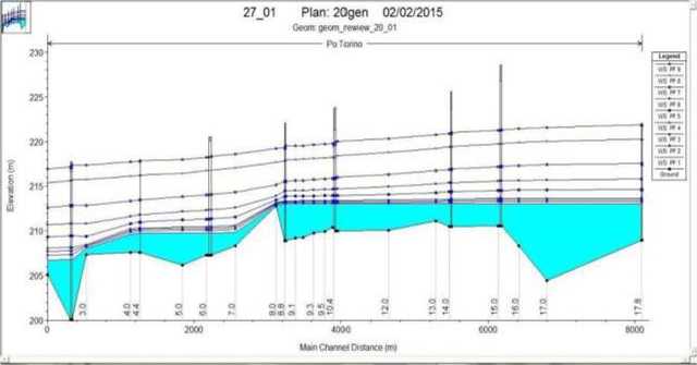
Figure 3 - Trend of the free water surface to the different flow regimes
Below, it is simulated obstruction at the section on the bridge Turin Marathon, arbitrarily changing the profile of the fund in order to simulate the accumulation of material at the section (for example accumulation of material between the logs and piles of bridges), which would otherwise occlude the outflow section of the current. In this case we were assumed three different entities occlusion: section obstructed at 25%. 50% and obstructed section completely blocked.
In relation to the last case (total obstruction and flow rate of 2700 m3/s) is shown the section and the relative level of the free surface (Figure 5). She was elected the gangway Turin Marathon because of the odd shape of its cells, which promote the accumulation of logs and other debris that can clog the flow section. At first, in Figure 4 is shown water surface level at different values of flow, in absence of obstruction on the section of Turin Marathon Bridge. As you can see. flow of 2700 m3/s is the most dangerous for the hydraulic conditions of exercise of the bridge also without obstruction.
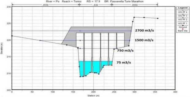
Figure 4 - Different level of water surface at different level of flows at Turin Marathon section without obstruction
We proceeded now to evaluate the effects of a possible total occlusion of the Turin Marathon Bridge, downstream of the same, to see if and how far affect the effects of this obstmetion. Simulating different flow rates, it is noted that downstream the free surface exceeds the bridges downstream of the crosspiece Michelotti. as can be obsen cd in Figure 6.
Screen_hnah_ponti_murazzi Plan 20gen 03/02/2015
Oom geom rewew ?0_01 Rw=Po ИемЯ'Твпео RS» 179 вя Panarato TuxnMntan
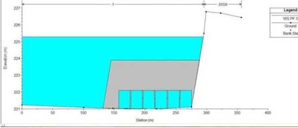
Figure 5 - Turin Marathon bridge in case of total obstruction of the section and with flow Q = 2700 m’/s
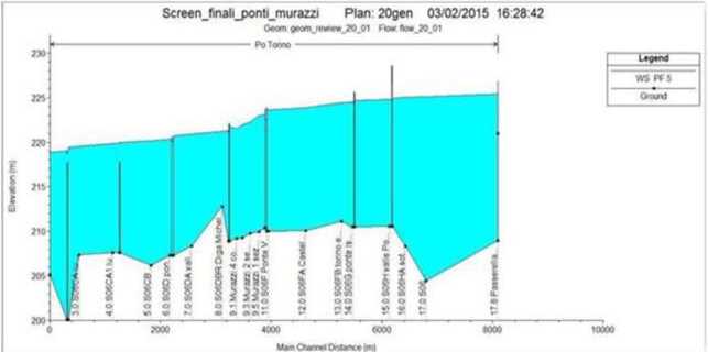
Figure 6 -Profile of free water surface in case of total obstmction of the section Turin Marathon bridge and with flow Q = 2700 m’/s
Therefore, there are environmental aspects to take into consideration, such as Minimum Vital Flow (DMV) and anthropogenic impact. For instream flow (Minimum Vital Flow), it means the minimum flow of a natural watercourse, which must ensure the protection of the physical, chemical - physical watercourse itself, as well as biotic (set of plant and animal species that live in a certain environment) typical of local natural conditions (Digs. 152 / Dlgs.258 1999 /2000).
Following the Presidential Decree. Council Reg. 17 July 2007. 8 / R. with regard to the minimum flow the Piedmont Region has determined tliat relatively auction PO riven downstream of the confluence of the Pellice. specifically in the section of our interest or between the confluence with the stream Sangone and the confluence with the Dora Riparia, the DMV (acronym of Minimum Vital Flow) must be quantified in 13 m3 / s. The DMV base (Basic DMV) in a particular section of the water body is calculated with the following formulation:
DMVbase = к * qmeda * S * M *A where:
к = fraction of the average annual flow (experimental parameter determined for each homogeneous areas)
4me S=basin surface area under the section of the water body, expressed in km' M=morphologic parameter A = parameter tliat takes into account the interaction between surface water and groundwater It is conceivable the exploitation of the maximum jump generated by the presence of Michelotti crosspiece, wliich is equal to 2,8 m. in the case of wanting to exploit 2 in ( about 65% of the total), to operate a plant for the mini - hydroelectric. As regards the operation of such a facility, it is necessary' to choose a turbine suitable for the flow rate tliat is to be exploited There are innumerable types of turbines, each suited to a specific. In this case, using data obtained from the duration curve of tire flow of the PO river, you choose the instrument as a result of different flow rate hypothesis to be derived and taking into account the reserved flow imposed by law, wliich is reminiscent be 13 m3 / s. It must first illustrate a simple classification of hydroelectric plants, in function of the maximum power tliat they manage to produce. Following, in Table 3 is illustrate the potential efficiency of Implant with the indicated hypothesis of levied flow shown in the same Table 3 because is reasonably tire most realizable. To estimate potential electric energy power generated from hydraulic head of Michelotti Crosspiece we need of some hydrological data (Curve of Yearly Average Duration of Flow Rate of Po river) in tract in exam. This is reported in Figure 7. It means on average for what number of days (horizontal axis) a determined flow rate is active (vertical axis). Table 3 Potential efficiency of Implant with the indicated hypothesis Levied Flow Energy produced indicated flow Duration of a single flow rare [days] Flow Q [m3 s] Fraction in % of Project Flow' Q Levied Q (m3/s) Efficiency of Kaplan turbine PWR. [NfWj % yearly Produced [MW*h] 10 136 1 60 0,86 1.012 0,027 242,97 10 116 0,8549 60 0,86 1 012 0,027 242 97 20 99 0,7328 60 0,84 0.988 0,054 474.64 20 79 0,5863 40 0,84 0.659 0,054 316.43 40 62 0,4517 40 0,84 0 659 0,109 632 86 60 48 0,3589 25 0,82 0.402 0,164 579.18 60 36 0,2696 20 0.82 0.321 0.164 463.34 60 28 0.2070 20 0.82 0.321 0,164 463.34 60 17 0,1288 10 0,8 0.156 0,164 226.02 With 10 days of yearly implant 3,174 GW*h Yearlv Figure 7 - Cune of Yearly Average Duration of Flow Rate of Po river in tract in exam |3-4| Conclusions. The study carried out hydraulically, on the stretch of river channel of the river Po. between the confluence with the stream Sangone and the Dora Riparia, is to be noted, the small amount of data available for the hydraulic characterization of the river, although it is a stretch of river ven important that flows in the urban environment. For example, it was not possible to find flow rates of PO with return periods (indicated as subscript measured in years) longer than a certain return period (T200. T500), dow nstream of the confluence with tlie Dora. In addition, the simulation of the obstniction to the gangway Turin Marathon, it was found that only ven 277 rare flow of 2700 m / s. the bridges downstream of the footbridge are likely to be reached by the flood water level. However, even with long return times, of the order of 200/300 years, tlte risk should not be considered non-existent in the case of total occlusion of tire outflow section. As regards the section of the Murazzi. it was observed that the level of tlte з river exceeds the levees for flow rate of about 500 m / s (Figure 7). Therefore, fairly regular intervals about once a year, that area is flooded. For what concern hypothesis of realization of a hydroelectric implant on the Michclotti Crosspiece, surely this could be ven impactful on the urban landscape. Furthermore, quantity of electric power potentially produced, is enough relevant to satisfy a great number of families that consume of each about for year 2700 kWh (kilowatt per hour) of electric energy [5]. As you can see. potentially electric implant could produce about 3.2 GWh (Gigawatt per hour) yearly. In my opinion, fortunately this report shows only a didactic example of Hec Ras software use to Hydraulic modeling of a river and at the moment is favorite to protect urban landscape of Turin center city, not use Michclotti crosspiece as a source of hydroelectric energy and save the typical and fascinating flow of the most important Italian river, the PO. Obviously, a hydraulic study similar to this is applicable in ail the rivers of the world, as long as they have tlte topographical and hydrological data (flow rate with associated return time) of the sections to insert in Hec RAS software.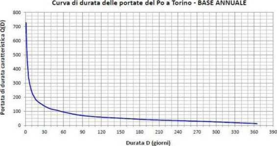
References Preliminary hydraulic study of the Po river in urban area through a steady flow simulation with HEC-RAS software and potential anthropogenic impact of an hydroelectric implant on the landscape
- Citrini D., Noseda G. Idraulica. Milano: Ed. CEA, 1987. - 480 p.
- Armanini A. Prinicipi di idraulica fluviale. Cosenza: Bios, 2005.
- Hydrological data about Po river // Authority of the Po River Basin (ADBPO) [Electronic source] URL: http://www.adbpo.gov.it
- Geometric data of fluvial sections of Po river [Electronic Source] URL: http://geoportale.agenziapo. it/cms/ index.php?option=com_aipograf& view=main&Itemid=10
- Estimation of average daily consumption of electric energy for family [Electronic Source] URL: http://www.centroconsumatori.it/40v2639 6d39183.htm
