Restoration of soils and vegetation in the agroecosystems of the taiga and steppe of the Selenga middle mountains (Western Transbaikalia)
")
Author: Sympilova D.P., Shakhmatova E.Yu.
Journal: Природа Внутренней Азии @nature-inner-asia
Section: Биология
Article in issue: 4 (26), 2023.
Free access
Agrogenically transformed soils in the mountain forest-steppe of Western Transbaikalia have been investigated. The morphological, chemical and physical properties of the Ap horizons 10-15-year old fallow lands have been studied. There is an increase in the content of organic carbon and exchangeable cations in agro-dark humus horizons. Soil pH decreases towards acidification. There is an increase in the content of the silt fraction in grain size distribution in soils. The structural composition of agro-dark humus horizons in two key plots is generally favorable due to the predominance of agronomically valuable fractions 0.25-10 mm. The water-stable structure of the agro-dark humus horizon of key plot 2K-13 is good and unsatisfactory of key plot 1M-13. The main stages of restoration of the fallow lands vegetation are revealed. The shrub stage of the steppe meadow reflects the next stage of demutation of steppe vegetation and further forestation of the territory.
Western transbaikalia, fallow land, agrogeniccally transformed soils, physicochemical properties, restoration of vegetation
Short address: https://sciup.org/148327742
IDR: 148327742 | UDC: 579.26(571.54) | DOI: 10.18101/2542-0623-2023-4-88-94
Восстановление почв и растительности в агроэкосистемах тайги и степи Селенгинского среднегорья (Западное Забайкалье)
Исследованы агрогенно-преобразованные почвы горной лесостепи Западного Забайкалья. Изучены морфологические, химические и физические свойства залежей 10-15-летнего горизонта Ар. В агротемногумусовых горизонтах увеличивается содержание органического углерода и обменных катионов. pH почвы снижается в сторону подкисления. Отмечается увеличение содержания илистой фракции в гранулометрическом составе почв. Структурный состав агротемногумусовых горизонтов на двух ключевых участках в целом благоприятный за счет преобладания агрономически ценных фракций 0,25-10 мм. Водоустойчивая структура агротемногумусового горизонта ключевого участка 2К-13 хорошая, а ключевого участка 1М-13 - неудовлетворительная. Выявлены основные этапы восстановления растительности залежных земель. Кустарниковый этап степного луга отражает следующий этап демутации степной растительности и дальнейшего облесения территории.
Text of the scientific article Restoration of soils and vegetation in the agroecosystems of the taiga and steppe of the Selenga middle mountains (Western Transbaikalia)
Intermountain valleys in Western Transbaikalia are confined to the gentle slopes of the foothill ridges. These landforms are covered by a layer of sand and loess-like deposit [Bazarov, 1968]. The climate of Western Transbaikalia is located within the transition climate zone between a cool continental climate (Dwc) and a cold semiarid climate
(Bsk) [updated world map of the Köppen-Geiger climate classification; Peel et al., 2007]. The average annual precipitation does not exceed 250 mm and most falls (50–55 %) in summer. The absence of a stable snow cover contributes to deep soil freezing. The exposure differences of the northern and southern slopes in terms of heat and moisture supply are so great that they lead to the coexistence of mountain steppes and mountain taiga without intermediate zonal subdivisions of vegetation.
The landscapes of the mountain forest-steppe in Western Transbaikalia are the most developed and are subject to the strongest anthropogenic pressures. Agrogenically transformed soils prevail in the structure of the soil cover. These soils have fertility due to the high saturation of the bases of the soil-absorbing complex. Soils are good agricultural land and intensively used.
Postagrogenic transformation of fallow soils is characterized by changes in morphological, physical and agrochemical properties. As result of agrogenic transformation, the soils involved in agricultural land use are degraded. Planar and linear erosion develops, the thickness of the humus layer decreases in the soil profile and the content of humus decreases, a plow base is formed, the structure changes, the bulk density increases, and the water resistance of aggregates decreases.
At present, the vegetation of fallow land is represented by a variety of meadows; of which steppe meadow occupy large areas and cab be rhizome and shrub [Novikova and Polozova, 2009].
The objective of this paper is to study of the regularities of the restoration of vegetation cover and changes in the content of morphological, chemical, and physical properties in the Ap horizons of agrogenically transformed soils.
Material and Methods
Soil morphology was described according to [Guidelines for Soil Description, 2006]. Soil types were determined according to [IUSS Working Groop... 2014]. Soil color was determined in the dry state using Munsell color charts. Physicochemical properties were carried out by conventional methods [Vorobyeva, 2006]. Particle-size distribution was analyzed by the pipette method according to Kachinsky. Structural and aggregate composition of soils was analyzed by the method of dry and wet sieving according to N. I. Savvinov [Field and Laboratory Methods... 2001].
Results and Discussion
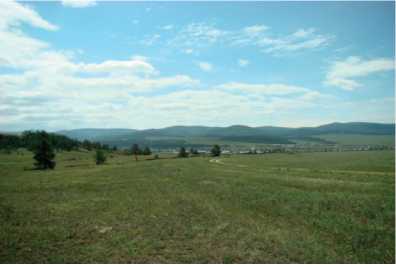
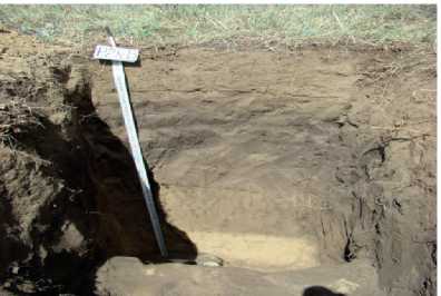
Pit 1M-13 was examined on the upper part of the hollow 4–5 km to southwest of the settlement of Maly Kunaley on the middle part of deluvial fan on the north-facing 7°–8° steep slope at 850 m a.s.l. under the shrub-grass-forb communities (Fig. 1 a , b ). The projective cover was 30-40%. The soil was identified as Eutric Cambisol (Protocalcic, Siltic) on loesslike loams. The Ap horizon is brownish-dark (10YR 3/2) dense; silt loam with crumb structure.
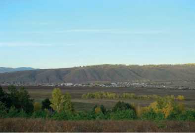
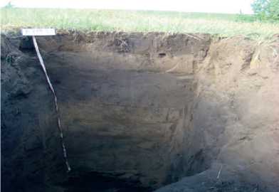
Pit 2K-13 was excavated 2 km to northeast of the settlement of Kuitun on the middle part of deluvial fan on the north-facing 6°–7° steep slope at 814 m a.s.l. under the grassherb communities (Fig. 1 c , d ). The projective cover was 20 %. The soil was identified as Eutric Cambisol (Protocalcic, Siltic) on loesslike loams. The Ap horizon is brownish-dark (10YR 4/2) dense; silt loam with lumpy-crumb structure.
a
b
c
Fig. 1. Eutric Cambisols (Protocalcic, Siltic) under the grass-herb communities (Pit 2K-13) and under the shrub-grass-forb communities (Pit 1M-13)
d
The percentage of agricultural land is one tenth of the total value of the land fund of the Republic of Buryatia. According to the All-Russian Agricultural Census [Land Resources and Their Use... 2018], in the Tarbagatai and Bichursky municipal districts, the total area of agricultural land is 26018.5 ha and 52396.4 ha of these, arable land accounts for 49 % and 48 %, fallow lands — 23 % and 11 %. A high percentage of fallow lands in the Tarbagatai region are associated with a high density of ravines.
Agrogenically transformed soils of Western Transbaikalia are formed on arable and fallow lands of deluvial fans. The soils are characterized by a brownish-dark gray humus horizon, gradually giving way to little-altered parent rock, lumpy-crumb and crumb structure, dense constitution, low humus content, which is associated with dehumification due to long-term use in agricultural production. All horizons are characterized by a neutral and slightly alkaline of soil reaction. Calcium predominates among the exchangeable cations [Sympilova and Badmayev, 2019].
The vegetations of 10–15-year-old fallow lands are represented by steppe meadows, which reflect the initial stages of regenerative successions with a high participation of weeds and xeromesophytes. The rhizome stage of the steppe meadow of Pit 2K-13 is represented by Elytrigia repens (L.) Nevski. The grass cover: Poa botryoides (Trin. ex Griseb.) Roshev., Carex pediformis C.A. Meyer, Bromopsis inermis (Leysser) Holub., Artemisia scoparia Waldst. Et Kit., Antennaria dioica (L.) Gaertn., Galium boreale L., Veronica incana L. The shrub stage of the steppe meadow of Pit 1M-13 is represented by a shrub-grass-forbs community. Shrubs occupy up to 10% and are represented Rosa acicularis Lindley, Cotoneaster melanocarpus Fischer ex Blytt, Spiraea salicifolia L., Caragana pygmaea (L.) DC. The grass cover: Carex pediformis C.A.Meyer, Bromopsis inermis (Leysser) Holub., Poa botryoides (Trin. ex Griseb) Roshev, Artemisia scoparia Waldst. et Kit., Potentilla tanacetifolia Willd. ex Schlecht., Antennaria dioica (L.) Gaertn., Aconitum barbatum Pers., Galium Boreale L., Urtica dioica L.
The shrub stage of the steppe meadow reflects the next stage of demutation of steppe vegetation and further reforestation of the territory.
Along with the succession of phytocenoses, there is an increase in the content of organic carbon and exchangeable cations in the Ap horizons. pH soil of the medium decreases towards acidification. In the grain size distribution in soils is observed an increase in the content of the silt fraction (Table 1).
Table 1
Physicochemical properties of the Ap horison of agrogenically transformed soils
|
Horizon, depth, cm |
pHH2O |
C, org g/kg |
C/N |
Ca2++ Mg2+mmol /100g |
Base saturation, % |
Particle size (mm) |
|
|
<0.001 |
<0.01 |
||||||
|
Pit 2K-07 |
|||||||
|
Ap (0-20) |
7.2 |
0.82 |
- |
17.2 |
- |
7 |
19 |
|
Pit 2K-13 |
|||||||
|
Ap (0-20) |
6.9 |
2.57 |
8 |
20.8 |
99 |
10 |
17 |
|
Pit 1M-13 |
|||||||
|
Ap (0-20) |
7.3 |
3.47 |
9 |
25.3 |
95 |
8 |
17 |
The structural composition of the Ap horizons of Pit 2K-13 and Pit 1M-13 is generally favorable due to the predominance of agronomically valuable fractions 0.25–10 mm. Structural coefficient is 2.03 and 1.75. The content of water-resistant aggregates is 52 % and 29 %, which indicates a good water-resistant structure of the Ap horizon of Pit 1M-13 (Fig. 2) and unsatisfactory of Pit 2K-13 (Fig. 3).
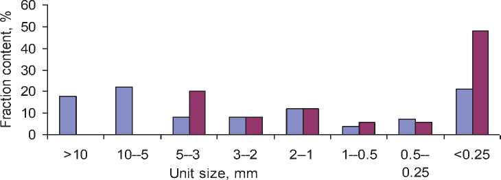
□ dry sieving □ wet sieving
Fig. 2. Structural and aggregate composition of the Ap horizon of agrogenically transformed soils (pit 2K-13)
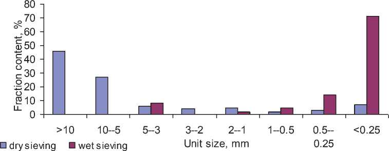
Fig. 3. Structural and aggregate composition of the Ap horizon of agrogenically transformed soils (pit 1M-13)
The bulk density of the Ap horizon of Pit1M-13 is favorable for the growth and development of plants. The compaction of the Ap horizon of Pit 2K-13 is much higher, as indicated by the lumpy-crumb structure (Table 2).
Physical parameters of the Ap horizon of agrogenically transformed soils
Table 2
|
Horizon, depth, cm |
Wet, % |
Bulk density, g/cm3 |
Total porosity, % |
|
Pit 2K-13 |
|||
|
Ap (0-20) |
11.1 |
1.43 |
47 |
|
Pit 1M-13 |
|||
|
Ap (0-20) |
19.8 |
1.18 |
54 |
Conclusions
The restoration of vegetation of 10-15-year-old fallow lands of steppe meadow using the example of Pit 2K-13 and Pit 1M-13 is represented by the rhizome and shrub stages. Self-restoration of agrogeniccaly transformed soils is characterized by an increase in the content of organic matter and exchangeable cations. pH soil of the medium changes towards acidification. The proportion of the silt fraction increases, the structural condition improves, and the bulk density decreases.
References Restoration of soils and vegetation in the agroecosystems of the taiga and steppe of the Selenga middle mountains (Western Transbaikalia)
- Bazarov D. B. Quaternary Deposits and the Main Stages of Development of the Relief of the Selenga Middle Mountains. Ulan-Ude, Buryat Book publ., 1968, 166 p. (In Russ.).
- Field and Laboratory Methods for Studying the Physical Properties and Regimes of Soils. Shein E. V. (Ed.). Moscow, Moscow University publ., 2001. 208 p. (In Russ.).
- Guidelines for Soil Description. Fourth edition FAO. Rome, 2006, p. 97.
- IUSS Working Group WRB. World Reference Base for Soil Resources 2014, update 2015.International Soil Classification System for Naming Soils and Creating Legends for Soil Maps. World Soil Resources Reports. FAO, Rome, 2015. No.106.
- Land Resources and Their Use (Results of the All-Russian Agricultural Census of 2016). Ulan-Ude, Buryatstat, 2018, p. 106 (In Russ.).
- Novikova L. A. and Polozova M. O. Restoration of Vegetation on the Fallows of the "Ostrovskaya Forest-Steppe". Vestnik OSU. 2009; 6: 286-290 (In Russ.). EDN: MNKTZF
- Peel M. C., Finlayson B.L., and McMahon T.A. Updated World Map of the Koppen-Geiger Climate Classification. Hydrology and Earth System Sciences. 2007; 4(2): 439-473.
- Sympilova D. P. and Badmaev N. B. Soil formation in the Taiga-Steppe Ecotone of the Selenga Mountains. Western Transbaikal Region. Eurasian Soil Science. 2019; 2(52): 122-132.
- Vorobyeva L.A. Theory and Practice of the Chemical Analysis of Soils. Moscow, GEOS, 2006, 400 p. (In Russ.).
