Russian and foreign experience of integration of agent-based models and geographic information systems

Author: Gulin Konstantin Anatolevich, Rossoshanskii Aleksandr Igorevich
Journal: Economic and Social Changes: Facts, Trends, Forecast @volnc-esc-en
Section: Modeling and forecast of socio-economic processes
Article in issue: 5 (47) т.9, 2016.
Free access
The article provides an overview of the mechanisms of integration of agent-based models and GIS technology developed by Russian and foreign researchers. The basic framework of the article is based on critical analysis of domestic and foreign literature (monographs, scientific articles). The study is based on the application of universal scientific research methods: system approach, analysis and synthesis, classification, systematization and grouping, generalization and comparison. The article presents theoretical and methodological bases of integration of agent-based models and geographic information systems. The concept and essence of agent-based models are explained; their main advantages (compared to other modeling methods) are identified. The paper characterizes the operating environment of agents as a key concept in the theory of agent-based modeling. It is shown that geographic information systems have a wide range of information resources for calculations, searching, modeling of the real world in various aspects, acting as an effective tool for displaying the agents' operating environment and allowing to bring the model as close as possible to the real conditions...
Geographic information system, spatial development, agent-based models
Short address: https://sciup.org/147223868
IDR: 147223868 | UDC: 330.4 | DOI: 10.15838/esc.2016.5.47.8
Text of the scientific article Russian and foreign experience of integration of agent-based models and geographic information systems
Currently, agent-based modeling is becoming a very popular tool; it is used in the scientific field and in the comprehensive managerial decision-making. This is largely due to the possibility to consider the activity of model elements, endowing them, besides the set of individual characteristics, with targets; whereby their response to changes in the environment in which they operate is simulated. Doctor of Economics A.R. Bakhtizin points out that the fundamental idea underlying agentbased models is to construct a “computing tool” (representing a set of agents with a specific set of properties) that help simulate real phenomena [1]. That is, agent-based modeling is used to study complex systems at the macro-level through the dynamic interaction of its elements at the microlevel (method “from below”).
C. Castle and A. Crooks [14, 23] note that among the advantages of agent-based models compared to traditional modeling methods (e.g., downstream non-linear dynamical systems, discrete-event simulation, cellular automata, etc.) it is possible to highlight three main aspects: 1) fixation of the phenomenon; 2) maintenance of natural environment to study certain systems; 3) flexibility, which is especially important when interacting with geographic information systems (GIS).
One of the main directions in the development of agent-based models (ABM) is to design ABM on the basis of geographic information systems. Many researchers prove the viewpoint that the real spatial data should not only be considered within the model, but also become elements of the model itself, and this involves static and exogeneity of spatial elements and their active and mutual participation. At first glance, the integration of ABM and GIS may look like a trivial task, but it helps to approximate the functioning of the agents to real processes and phenomena as close as possible.
The aim of the present paper is to systematize modern domestic and foreign experience of integration of agent-based models and geographic information systems. To achieve this goal the authors consider potential and real areas of their application, give an overview of the most popular platforms for their integration, and consider the most successful agentbased models based on GIS.
Along with the “agent” as a central term and basic functioning unit in the theory and practice of agent-based modeling, the environment for their functioning is the major element in ABM. That is, the interaction between agents is not performed as if in a “vacuum” (where the “agent-agent” links are present), rather it takes place in a given space that also has a direct or indirect impact on the agent’s decision-making (“agent-agent” and “agent-environment”). Figure 1
presents a conceptual illustration of the key types of relationships between agents and environment. This interaction between agents in space is called “spatially explicit”, even if the agent itself is static. At the same time, agent-based models do not rule out the possibility of interaction between agents without regard to spatial location, i.e. the agents can be “spatially implicit” [11]. The very environment in which the agents exist can be represented as a physical or social space of a given shape and size, characterized by the possible states, spheres of influence, definite rules of dynamic measurement, and many others [8, p. 32].
An essential tool in the effort of agentbased models to the fullest reflection of reality is the representation of the environment of agents in the form of geographic information systems. Academicians V.L. Makarov and V.V. Okrepilov note that such an integration is “absolutely natural” and essentially brings agent-based models to an environment that is close to reality [3, p. 713].
The term “geographic information system” was introduced into scientific practice in the 1960s by R.F. Tomlinson when electronic spatial information system was created in Canada [6]. This concept was consistent with a new technology of using computers for storing and processing data associated primarily with natural
Figure 1. Variants of interaction between the environment and the agents a) identity relationships, b) causality, c) temporal relationships, d) topological relationships
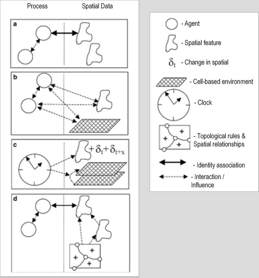
Source: Brown D.G., Riolo R., Robinson D.T., North M., Rand W. Spatial process and data models: Toward integration of agent-based models and GIS. Journal of Geographical Systems , 2005, volume 7, pp. 25–47.
resource management (e.g., mapping of old-growth forests, the system for protected nature technologies in the United States, etc.). In this regard, it would have been difficult to imagine GIS that were initially used for the analysis and visualization of spatial data in the role of a dynamic simulation modeling tool and especially as an independent platform for agent-based modeling [5].
It should be noted that the term “geographic information system” can be considered from two perspectives [2, 6]. First, GIS is a hardware and software system that stores and uses data that describe objects in space. Second, GIS is an information and reference system.
Currently, geographic information systems have heterogeneous information resources that are logically united with a cartographic basis and used for calculations, retrieval, and simulating the real world in various aspects. The most common software for developing and managing GIS are as follows: a family of software products of the American company ESRI (e.g., ArcGIS Online, ArcGIS for Desktop, ArcGIS for Server, ArcGIS Apps, and others); a family of software products Mapinfo GIS; GeoGraf GIS developed by the Center for Geo-Information Studies at the Institute of Geography, RAS; Geomedia developed by Intergraph Corporation, etc.
Modern GIS are able to solve a wide variety of tasks, such as tracking the movement of vehicles, searching for the optimal path taking into account transport characteristics, forecasting the environmental situation, etc. Due to the increasing functionality of the software, standard functions of any geographic information system include: import and export of data; data storage and management; data visualization; processing and analysis; modeling.
From researcher’s point of view, the integration of ABM and GIS provides the ability to review the activities of agents in real geographic coordinates (within a given district, municipality, region, country, etc.). This in turn makes it possible to track the emergence of phenomena or processes in the course of individual interactions of agents in GIS in time and in space; this gives an opportunity to develop various mechanisms for decision-making, whether the rationale for the placement of a new shopping center, or the regulation of migration processes [3, 13].
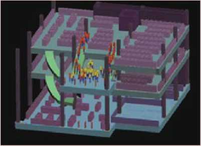
A. Crooks proposes a model of the world [13] (Fig. 2) as an example of the most informative display of possible integration of ABM and GIS technology. The model is represented as a set of layers and objects of different types (e.g., vehicles or people – as non-fixed objects, and buildings or
Figure 2. Display of the world as a set of layers of fixed and non-fixed objects
The World
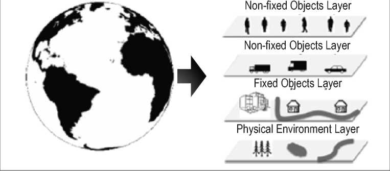
Source: Brunsdon C., Singleton A.D. Geocomputation: A practical Primer . London: SAGE Publications Inc., 2015. Pp. 63–77.
structures – as fixed objects). The layers form an artificial world for the agents and may represent a well-defined space, such as the roads by means of which the agents can get from point A to point B, residential districts, or place of work.
The following example (Fig. 3) illustrates the modified model SLEUTH1, which forecasts the change in the scale of urbanization growth of the cities. In this case, the model is run with certain scenarios of growth of urbanization level of the cities, calculated according to specified growth factors. Spatial data allow for adjustment of the model, namely they help answer the question whether the developed growth scenarios are valid. That is, the growth rates used in the model can be calibrated so that the data calculated on the set of agents coincides with the real data [7]. Subsequently, the compliance of the model to reality will allow us to speak about the reliability of the forecasts.
Potential and actual applications of ABM based on GIS
Agent-based models provide a wide range of opportunities for the implementation of the diverse range of research in various spatial and temporal frameworks. The list of questions under consideration covers time ranges from short-term solutions in the process of movement of
Figure 3. Land use dynamics in Santa Fe, New Mexico
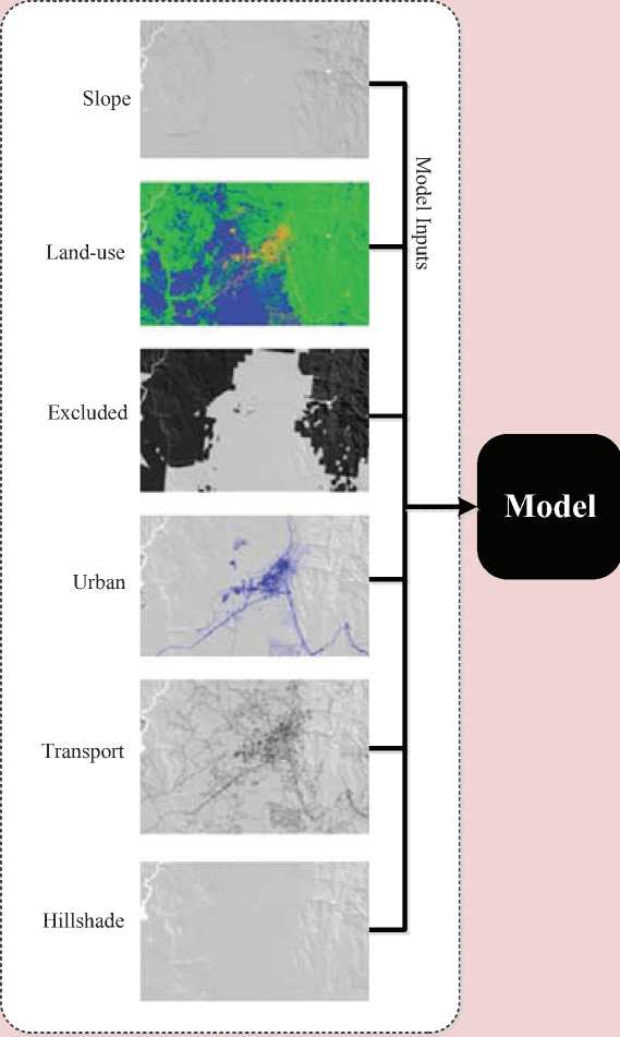
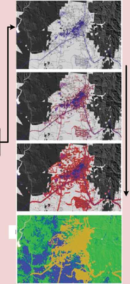
Land-use change
Source: Brunsdon, C., Singleton, D.A. Geocomputation: A practical Primer. London: SAGE Publications Inc., 2015. Pp. 63-77.
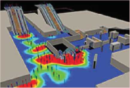
pedestrians [16] to migration processes [22] that last years or even decades. Agent-based models in conjunction with GIS-technology are successfully used in various fields of science, ranging from the natural and engineering sciences to the social and humanitarian sciences. ABM are artificial laboratories, a kind of artificial societies, allowing us to verify ideas and hypotheses about phenomena which are often very difficult to recreate in the real world2. A visual example is the case of simulation of evacuation of people from a building in case of fire. The reconstruction of an emergency situation in an artificially created world (in this case it is the building on fire), populated by artificial people (they can be people living
a
Figure 4. Floor plans for the building: a – places of initial location of people; b – movement of people to the exits
b
Source: Kholshchevnikov V.V., Samoshin D.A., Parfenenko A.P., Kudrin I.S., Istratov R.N., Belosokhov I.R. Evakuatsiya i povedenie lyudei pri pozharakh : ucheb. posobie [Emergency evacuation and rules of conduct in case of fire: training manual]. Moscow: Akademiya GPS MChS Rossii, 2015. 262 p.
or working in the building), helps identify potential problems, such as the influence of the density of flow of the people on the stairs and in the corridors on the dynamics of leaving the floor of the building. The accuracy of the models obtained is ensured through the use of natural observations verified by statistics and the experiments previously conducted.
Figure 4 shows the simulation-stochastic model “Evatek” which demonstrates the movement of the flows consisting of people of various degrees of mobility. The operating environment for the agents is presented in the form of two layers which clearly show the concentration of the agents in close proximity to stairways and narrow corridors.
It should be noted that this example is very revealing, because it shows the importance of visualization of the space in which the agents are involved, and in any case it does not limit the scope of its application only to security matters. Agent-based modeling in conjunction with geographic information systems allows us to solve a wide range of tasks such as: analysis and prevention of congestions during rush hours in the downtown, planning of the potential spread of disease, optimization of timber harvesting, analysis of crime rate to prevent future offenses.
Technical support of integration of ABM and GIS
Currently, there are two ways to integrate ABM and GIS [5]. The first method is to create weak (incomplete) or strong connections between ABM and GIS, in this case software products work individually. The second method involves the creation of a unified system based on ABM or GIS.
Given the fact that “agent-based modeling does not require the use of specialized programs, which in principle allows for the use of a multiple types of development tools” [1], we shall take a closer look at modern platforms that support the creation of a unified system: ABM-centric and GIS-centric systems.
K. Kravari and N. Bassiliades in the article “A Survey of Agent Platforms” [25] conducted a comparative analysis of twenty-four most promising platforms for agent-based modeling. Note that seven of them ( AGLOBE, AnyLogic, GAMA, Repast, MASON, NetLogo and Swarm ) support the use of GIS-technologies, i.e. are ABM-centric models. For comparison, let us consider two variants of geographic information systems (ENVISION and ArcGIS) that allow for building agentbased models. Main characteristics of the aforementioned platforms are shown in Table 1 .
The classification of platforms, from the point of view of the programming language is very convenient from viewpoint of the researcher who decides to model certain processes. As can be seen from the table, the majority of platforms under consideration are written in programming languages C, C++ and Java, which is true for ABM in general.
FIPA (The Foundation for Intelligent Physical Agents) is an international organization for standardization of interoperability of heterogeneous agents in ABM. Compliance with FIPA provides some advantage in promoting software products through guaranteeing the compliance with the architecture of the agents and work of the system. However, this condition is not necessary: for example, AGLOBE only supports the technical standards related to communication principles.
The use of agent-based models based on GIS in studies of socio-economic processes
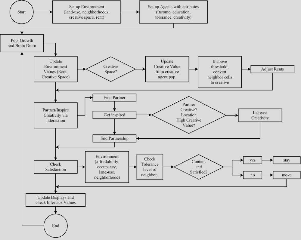
Creative City Model. A group of researchers at George Mason University ( A. Malic, A. Crooks. H. Root, M. Swartz ) [19] uses an agent-based approach to study the influence of creative potential on the development of cities. The model is based on the assumption that the leading cities of the world attract the most talented people, offering them not only the best professional opportunities, but also a high level of development of cultural and leisure spheres (e.g., theaters, art galleries, exhibitions, concerts, etc.) and public services (e.g. health, education, etc.) [20]. Through the implementation of the model,
Table 1. Modern platforms that support the integration of ABM and GIS
Name (developer) Year of product launch Programming language Open source Required level of programming Integration mechanism Compliance with FIPA Performance AGLOBE (Czech Technical University) 2003 Java Yes Basic ABM-centered Partial High AnyLogic (The AnyLogic Company) 2003 Java, UML-RT (UML for real time) No Basic ABM-centered Absent High GAMA (IRD/UPMC International Research Unit UMMISCO) 2007 GAML Yes Basic ABM-centered Partial Above median Repast (University of Chicago) 2003 Java, C#, C++, Lisp, Prolog, Python Yes Basic ABM-centered Absent High MASON (George Mason University) 2003 Java Yes Basic ABM-centered Absent Above median NetLogo (The Center for Connected Learning (CCL) and ComputerBased Modeling, Northwestern University) 1999 NetLogo No Basic ABM-centered Absent Above median Swarm (Santa Fe Institute / SWARM Development Group, USA) 1994 Objective-C / Java Yes Basic ABM-centered Absent Median ENVISION (Oregon State Univeristy) 1998 С++, Delphi, Visual Basic и др. поддерживающие COM технологии Yes Advanced GIS-centered Absent Median ArcGIS (ESRI) 1999 C++, Python Yes Advanced GIS-centered Absent Median Sources: compiled by the authors with the use of the following source: Kravari K., Bassiliades N. A Survey of Agent Platforms. Journal of Artificial Societies and Social Simulation, 2015, no. 18 (1) 11. Available at: the authors try to answer several questions: what are the main factors that hinder the emergence of creative clusters in the cities of developing countries? What spatial and socio-economic conditions contribute to their emergence? The authors highlight the following factors that contribute to the formation of creative cities: population density, urban and regional mobility, social tolerance.
The model is designed as a tool for understanding the relationship between human creativity and urban development. Agents in the model represent people who are “spatially explicit” and possess the following set of characteristics:
-
1. Creativity: low, medium, high.
-
2. Education level: educated and uneducated.
-
3. Income level: 1,000 – 35,000 units.
-
4. Tolerance: 1 – 99%.
Due to increased attention to megacities of developing countries, we have chosen the city of Karachi as the environment for the functioning of agents. The zoning of the environment was carried out in accordance with current local legislation: residential area (60%), commercial area (10%), green area (10%), water area (10%), infrastructure (10%).
Visual representation of the environment was carried out with the help of Google Earth. The information base for the model was the data of a sociological survey of young people who live in Karachi [27], the survey reflects the following characteristics: education level, the brain drain, creativity level, income distribution, tolerance level. The number of agents in the model is 2,100, which comprises 0.01% of the population. The model is developed on the basis of the NetLogo platform.
The behavior of the agents in the model:
-
1. Mobility of the agents. The movement of the agents in the model is motivated by their desire to raise the level of general satisfaction, which depends on the cost of rent and monitoring of social segregation.
-
2. Spread of creativity. The development of multifunctional design (i.e. combining residential, commercial and other types of land usage), transport accessibility, pedestrian infrastructure, public areas creates the conditions to attract talented and creative people.
-
3. Income and the rental market. Increasing the level of creativity of agents (for example, due to the interaction with the agents of a higher level of creativity) leads to an increase in the level of incomes. The agents in the model can also lose a level of creativity in the absence of interaction with other agents. Increasing the creative potential of the agents leads to higher requirements to the housing conditions and the quality of the urban environment, which in turn increases the
-
4. Population growth and the brain drain. User-defined growth rate of agents in the model have an impact on all agents regardless of their level of creativity.
cost of rent payments. As a consequence, less wealthy agents lose access to the highly productive creative clusters, which leads to increased income inequality.
However, the brain drain only affects agents whose creativity is low.
Ultimately, the interaction between the agents leads to the emergence of creative clusters, which has a positive impact on the economic development of cities (Fig. 5) . However, clustering also generates the problem of socio-economic inequality.
Figure 5. Creative City Model
Source: Malic A., Crooks A., Root H., Swartz M. Exploring Creativity and Urban Development with Agent-Based Modeling. Journal of Artificial Societies and Social Simulation, 2015, no.18 (2). Available at:
Humanitarian Assistance Model. Agentbased modeling using geographic information systems, exploring the effects of catastrophic events is considered in the work by A. Crooks and S. Wise [18]. The authors present a pilot model that simulates the behavior of agents in Port-au-Prince after the earthquake in January 2010. The model consists of several modules that cover physical and social processes in the delivery of humanitarian assistance.
In this model there are two types of agents:
-
1) centers of humanitarian assistance (centers);
-
2) victims.
The centers also act as immovable objects located in the environment, and, like the agents, endowed with a certain amount of resources that they distribute among the victims. Every center has its own coverage network of victims and the number of units of humanitarian assistance on one victim. The goal of the centers is to provide material resources to the victims, that is, to satisfy their basic need – the need for survival.
The victims have a certain energy level and knowledge about the environment, such as the location of their home and possible location of humanitarian assistance center. The key attribute of the victims is the energy level which characterizes their health. The achievement of zero values means the death of the agent and removal from the model. The initial energy level of agents is specified with regard to the proximity of their place of residence to the areas of disaster.
The victims make decisions in accordance with their goal – to maximize the energy level. They choose one of several actions: for example, to get to the help center or stay at home. The interaction of agents among themselves suggests there will be no cases when false information is given about the location of help centers, as well as the cases of deliberate concealment of information.
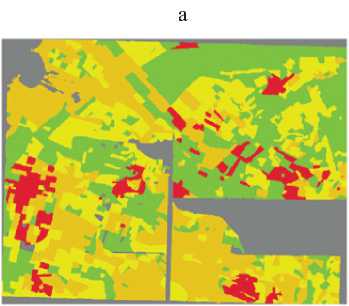
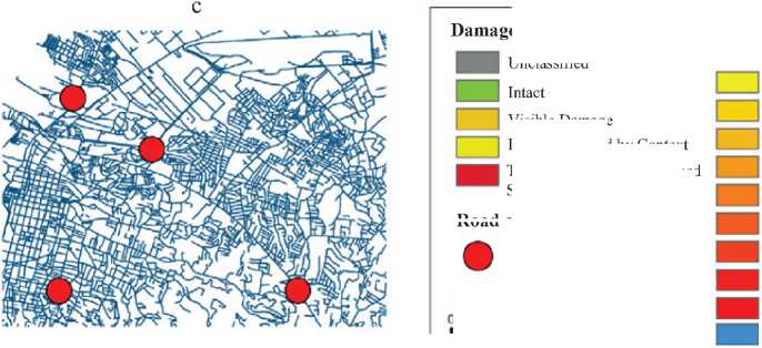
Figure 6 presents a detailed view of the operating environment for the agents. The input data is information about the level of damage (Fig. 6a) , population density (Fig. 6b) , existing transport networks and the location of humanitarian assistance centers (Fig. 6c) , and about several auxiliary parameters.
The authors emphasize that the regions affected by natural disasters experience a lack of informational resources necessary for the adequate and timely response. Information base for the model is generated through crowdsourcing and VGI data (the so-called volunteered geographic information [21]). In particular, the data on population density were obtained from
Figure 6. Fragment of GIS in Port-au-Prince
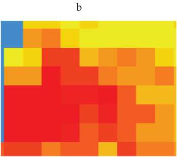
Population
No. of People per Km
Unclassified
0-706
707-1,461
1,462-3.825
3.826 - 9.298
9,299- 13,701
13.702 - 19,746 19,747-30,144 30,145-41.106 41,107 -58.187
Water
Aid Points
Roads
» 0.5 1 15 2 15 Зп ,
Kilometers
Visible Damage
Damage Infered by Context
Totally Destroyed / Collapsed Structures
a) damage; b) population; c) transportation network and the location of aid points.
Road and Aid Points
Source: Crooks A.T., Wise S. GIS and Agent-Based models for Humanitarian Assistance. Computers, Environment and Urban Systems , no. 41, 2013, pp. 100–111.
population distribution models LandScan; the data on the level of damage were taken from G-Mosaic; OpenStreetMap was used to display transport networks.
The result of the model is presented by several statistics facts: the number of deaths of the agents, the number of units of humanitarian assistance that the victims did not obtain, the total amount of energy used by the agents who survived.
The model demonstrates the potential of using crowdsourcing and VGI data as sources for designing a realistic operating environment for the agents in order to simulate the behavior of individuals in case of critical situations. According to the authors, the developed model can be used as a support tool when making decisions about the provision of humanitarian assistance.
Summarizing the capabilities of agentbased modeling on the basis of geoinformation systems, we note that this tool helps not only create the agents close to reality, but also integrate them into existing physical and social space in real time. This, in turn, speaks about the prospects of using agent-based modeling, including its use in making effective and timely management decisions. However, leading Russian (V.L. Makarov, A.R. Bakhtizin) and foreign (A. Heppenstall, A.
Crooks, M. Batty, etc.) scientists point out that the key problem at the moment is the operating speed of agent-based models based on GIS, that is, the possibility to run complex models with thousands of spatially-aware agents. At the moment the solution is seen, first, in reducing the informative value of GIS to the required number of characteristics of the space that are accessed by agents during operation; second, in increasing performance of modern processors.
References Russian and foreign experience of integration of agent-based models and geographic information systems
- Bakhtizin A.R. Agent-orientirovannye modeli ekonomiki . Moscow: Ekonomika, 2008. 279 p..
- Vvedenie v geoinformatsionnye sistemy. Geograficheskie informatsionnye sistemy i distantsionnoe zondirovanie . Available at: http://gis-lab.info..
- Makarov V.L., Okrepilov V.V. Printsipy monitoringa kachestva zhizni na osnove agent-orientirovannykh modelei . Vestnik Rossiiskoi akademii nauk , 2016, no. 8, pp. 711-718..
- Makarov V.L., Bakhtizin A.R. Sovremennye metody prognozirovaniya posledstvii upravlencheskikh reshenii . Upravlencheskoe konsul'tirovanie , 2015, no. 7, pp. 12-24..
- Makarov V.L., Bakhtizin A.R. Sotsial'noe modelirovanie -novyi komp'yuternyi proryv (agent-orientirovannye modeli) . Moscow: Ekonomika, 2013. 295 p..
- Seredovich V.A., Klyushnichenko V.N., Timofeeva N.V. Geoinformatsionnye sistemy (naznachenie, funktsii, klassifikatsiya): monografiya . Novosibirsk: SGGA, 2008. 192 p..
- Sushko E.D. Mul'tiagentnaya model' regiona: kontseptsiya, konstruktsiya i realizatsiya: preprint # WP/2012/292 . Moscow: TsEMI RAN, 2012. 54 p..
- Fattakhov M.R. Agent-orientirovannaya model' sotsial'no-ekonomicheskogo razvitiya Moskvy . Ekonomika i matematicheskie metody , 2013, no. 2, pp. 30-43.
- Chekmareva E.A. Obzor rossiiskogo i zarubezhnogo opyta agent-orientirovannogo modelirovaniya slozhnykh sotsial'no-ekonomicheskikh sistem mezourovnya . Ekonomicheskie i sotsial'nye peremeny: fakty, tendentsii, prognoz , 2016, no. 2, pp. 225-246..
- Kholshchevnikov V. V., Samoshin D.A., Parfenenko A.P., Kudrin I.S., Istratov R.N., Belosokhov I.R. Evakuatsiya i povedenie lyudei pri pozharakh: ucheb. posobie . Moscow: Akademiya GPS MChS Rossii, 2015. 262 p..
- Heppenstall A., Crooks A.T., See L.M., Batty M. (Eds.). Agent-based Models of Geographical Systems. New York: Springer, 2012. 746 p.
- Benenson I., Torrens P. Geosimulation. Automata-based modeling of urban phenomena. Chichester: Wiley, 2004. 312 p.
- Brunsdon C., Singleton A.D. Geocomputation: A practical Primer. London: SAGE Publications Inc, 2015. Pp. 63-77.
- Castle C.J.E., Crooks A.T. Principles and Concepts of Agent-Based Modelling for Developing Geospatial Simulations. Centre for Advanced Spatial Analysis (University College London): Working Paper 110, 2006. 62 p.
- Clarke K.C., Hoppen S., Gaydos L.J. A Self-Modifying Cellular Automaton Model of Historical Urbanization in the San Francisco Bay Area. Environment and Planning B, 1997, no. 24(2), pp. 247-261.
- Crooks A., Croitoru A., Lu X., Wise S., Irvine J.M., Stefanidis A. Walk This Way: Improving Pedestrian Agent-Based Models through Scene Activity Analysis. International Journal of Geo-Information, 2015, no. 4(3), pp. 1627-1656.
- Crooks A.T. Constructing and Implementing an Agent-Based Model of Residential Segregation through Vector GI. Centre for Advanced Spatial Analysis (University College London): Working Paper 133, 2008. 42 p.
- Crooks A.T., Wise S. GIS and Agent-Based models for Humanitarian Assistance. Computers, Environment and Urban Systems, no. 41, 2013, pp. 100-111.
- Malic A., Crooks A., Root H., Swartz M. Exploring Creativity and Urban Development with Agent-Based Modeling. Journal of Artificial Societies and Social Simulation, 2015, no.18 (2). Available at: http://jasss.soc.surrey.ac.uk/18/2/12.html
- Florida R. Cities and the Creative Class. City & Community, 2003, volume 2, pp. 3-19.
- Goodchild M.F. Citizens as sensors: the world of volunteered geography. GeoJournal, 2007, no. 69, pp. 211-221.
- Gulden T., Harrison J.F., Crooks A.T. Modeling Cities and Displacement through an Agent-based Spatial Interaction Model. The Computational Social Science Society of America Conference, 2011. Available at: https://www.researchgate.net/publication/267800670_Modeling_Cities_and_Displacement_through_an_Agent_based_Spatial_Interaction_Model
- Heppenstall A., Crooks A.T. Agent-based modeling in geographical systems. Available at: https://dl.dropboxusercontent.com/u/2696623/Website/AccessScienceABM.pdf
- Johnston K.M. Agent-based modeling in ArcGIS. California: Esri Press, 2013. 559 p.
- Kravari K., Bassiliades N. A Survey of Agent Platforms. Journal of Artificial Societies and Social Simulation, 2015, no. 18 (1) 11. Available at: http://jasss.soc.surrey.ac.uk/18/1/11.html
- Niaz Arifin S.M., Reaz Arifin R., Dilkushi de Alwis Pitts, Sohel Rahman M., Nowreen S., Madey G.R., Collins F.H. Landscape Epidemiology Modeling Using an Agent-Based Model and a Geographic Information System. Land, 2015, no. 4, pp. 378-412.
- Malic A., M. Karim Karachi Youth Survey: Attitudes, Ambitions and Entrepreneurial Potential of Karachi's Youth. USIP Conference, Washington, DC, 2012.
- Brown D.G., Riolo R., Robinson D.T., North M., Rand W. Spatial process and data models: Toward integration of agent-based models and GIS. Journal of Geographical Systems, 2005, volume 7, pp. 25-47.
- Puusepp R., Cerrone D., Melioranski M. Synthetic Modelling of Pedestrian Movement. SPATIAL ANALYSIS. Urban Context, volume 2, pp. 473-481.
