Small satellites for sea surface sounding

Author: Kartsan I.N., Zhukov A.O.
Journal: Siberian Aerospace Journal @vestnik-sibsau-en
Section: Aviation and spacecraft engineering
Article in issue: 2 vol.23, 2022.
Free access
The paper presents a method of processing signals of radar sensing of the underlying surface using il-lumination from existing spacecraft (navigation, communication) and a constellation of small receiving spacecraft using synthetic aperture antennas. Methods and Results. Small spacecraft have many advantages over large satellites. Thus, they are rela-tively inexpensive to build, take minimal time from design to launch, can be easily modified to solve a particu-lar problem, and create less radio interference. The approach under consideration consists in redistribution of tasks to be solved between the constellation of satellites in orbit. Both regular high-orbit communication satellites and low-orbit satellite communication systems, as well as navigation satellites are represented as transmitter carriers (underlying surface illumination). These space systems use the necessary broadband sig-nal. Receivers of reflected signals are placed onboard small spacecrafts, and one of the tasks of the system is to perform research experiments, including on-line monitoring of fast-moving atmospheric cyclones. The work applies the method of sea surface radar imaging based on reflected signal models. The main results of the research are as follows: (1) possibility to use as a probing signal both a pulse and a broadband signal with a priori unknown modulation law, (2) acceptable resolution, (3) possibility to significantly reduce the system cost as compared to the existing space radars of sea surface survey. Conclusions. As a result of using a multi-position radar system, which uses small receiving antennas with synthetic aperture and sea surface illumination from operating spacecraft, it is possible to move to a qualitatively new level of solving problems of sea surface remote sensing with spatial resolution up to 1 meter, regardless of illumination and cloud cover presence.
Small spacecraft, receiving antennas with synthetic aperture, floodlight view mode, radar imaging of the sea surface
Short address: https://sciup.org/148329625
IDR: 148329625 | UDC: 551.46.09 | DOI: 10.31772/2712-8970-2022-23-2-262-272
Text of the scientific article Small satellites for sea surface sounding
Since the beginning of space exploration, a large number of remote sensing satellites have been launched and a huge number of experiments have been carried out to assess the possibilities of using new methods for global monitoring of land and ocean objects. The study of the World Ocean by more efficient methods fully falls in the plan for the implementation of the "Decade of Ocean Sciences for Sustainable Development" (2021-2030) and brought into line of the most important problems of science and technology, which is associated with its increased importance in the life of mankind. However, despite the ever-increasing intensity of studying the ocean, the level of today's knowledge about the processes taking place in it is far from meeting practical needs. For more detailed and operational monitoring of non-stationary processes in the World Ocean with diagnostics of their parameters, the need to obtain information about ongoing processes with a minimum repetition time of the generated images increases.
At present, the term "small spacecraft" (SSC) defines not only weight and size characteristics, but also a fundamentally new, constantly progressing construction architecture. The architecture of the SSC construction determines the actual weight and size dimensions, cost characteristics, personal (payload), user equipment, launch system (both during constellation creation and operational replenishment) and real-time operational control system [1–3]. Small satellites also include nanosatellites (weight from 1 to 10 kg), picosatellites (weight from 100 g to 1 kg), femtosatellites (weight up to 100 g) in terms of weight dimensions. This type of MCA is not considered in the present work due to the minimum power supply.
The use of small spacecraft will allow moving to a higher productive level of solving the tasks of remote sensing due to the possibility of prompt deployment or replacement of the small spacecraft constellation. The use of side-scan radar with a synthetic aperture is confirmed by one of the first experiments in history on the Seasat spacecraft. The main purpose of the experiment was to assess the degree of all-weather microwave methods for studying the World Ocean, processing methods and algorithms for complex measurements of hydrometrological parameters and data processing [4]. The Synthetic Aperture Side-Scan Radar in the present experiment operated in the L-band at an operating frequency of 1.275 GHz with a 100 km wide ground swath to starboard centered at 20º from nadir. Synthesizing the aperture made it possible to obtain a spatial resolution on a terrain of 25 m.
A distinctive feature of the oceans’ study from space is that they are often covered by clouds; the synthetic aperture method in this sense makes it possible to overcome the shortcomings of optical sounding systems. In the long term, the presented method made it possible to simultaneously obtain independent multi-angle radar images of the observed area for measurements: statistical characteristics of the height, length and energy spectra of ocean waves; topography of the sea surface, which is information about the geoid, storm waves, tides, ocean currents, as well as determining the size and nature of sea ice [5; 6].
Currently space-based active synthetic aperture radars (SARs) have relatively large antenna sizes (4–15 m), the total weight of the equipment reaches 500 kg
Survey Modes by Small Spacecraft with Synthetic Antenna Aperture
. The surface of the sea has features that include many (if not all) of the characteristics of other surfaces. Since we are talking about radar, the scattering process takes place only at the surface or very close to it, since the penetration depth of electromagnetic radiation at the operating frequencies of synthetic aperture radar is very small. Methods for modeling the sea surface can be divided into three categories: almost flat surfaces, very rough surfaces, and combinations of the first two. The distinction between almost flat and very rough surfaces is made according to on whether the wavelength of the incident radiation is large or small compared to the deviation of the surface from a certain average plane. Almost even surfaces were successfully analyzed by solving Maxwell's equation at the interface with approximate satisfaction of the boundary conditions. The only successful approach in the case of very rough surfaces is the analogy with physical optics. However, this method has a serious drawback: it does not take into account the effects of dimming or multiple scattering.
Moreover, the necessary condition is violated - the radii of curvature of the surface must be greater than with the long wavelength of the incident radiation, and it is difficult to take into account the effect of depolarization. Due to the complex influence of factors that determine the operation of space systems with SAR, the choice of optimal parameters is a complex engineering problem. The terms of reference for the SAR usually define the orbital altitude, the required range and resolution in azimuth, the capture zone and the band (capture zone tuning band), as well as design characteristics and power consumption. Maximum horizontal dimension of the antenna Dr < 2δX which can be set by design considerations or by the results of calculations of observation modes and equipment parameters, is determined by the specified resolution [7]
The radar image contains many easily distinguishable and identifiable features and bears a clear resemblance to images obtained by optical instruments, but this resemblance is deceptive. It includes many results of reflections from a surface that is exposed to radiation with wavelengths many orders of magnitude greater than that of visible light. The resolution of optical systems used in remote sensing is rarely limited by diffraction at a given aperture. With radar, this phenomenon is almost inevitable. The radar is also a source of radiation whose reflection is captured to produce an image, i.e. it is an active remote sensing instrument, not a passive one. Currently, the active optical system is lidar - a rangefinder of the optical range. The radar irradiates the rotating curved surface of the Earth with radio waves with a spherical front. Early aircraft-based systems usually did not take into account these geometric features due to the low altitude of the SAR, but they must be taken into account in spacebased systems. As a result, the distance from the radar to an individual point of exposure changes as the point of observation moves – a "range wander" effect. There are two components responsible for this effect: the quadratic term due to the Earth's curvature and the linear term due to the Earth's rotation. Each dot must be traced across the entire synthetic aperture to eliminate this effect, although the actual behavior for an individual dot will depend on latitude and range. During processing, a range-dependent quadratic phase shift must be added in the direction of travel of the apparatus to compensate for the curvature of the reflected wavefront.
The desire to ensure a sufficiently high frequency of observation of a given water area at an acceptable cost may well be achievable when creating an orbital group (OG) of a new generation of small spacecraft with SAR. At the same time, small satellites with SAR with an average resolution level, but with a large survey swath, most fully meet the requirements for observing the marine situation [8; 9].
One small spacecraft with an orbit altitude of 1500 km per day, over one point of the sea surface, can carry out radar sounding at least 6 times. To quickly obtain information on the state of the sea surface from SSCs at an orbital altitude of 1500 km, it is necessary to create a constellation with 4 orbits of 3 SSCs each, by analogy with the orbital constellation of the Gonets-D1M multifunctional personal satellite communication system.
The choice of the survey mode depends on the task and the technical characteristics of the small spacecraft and is subdivided into:
-
– broadband mode along the route;
-
– rectilinear narrow beam mode along the route;
-
– searchlight mode, taking into account the visibility zone.
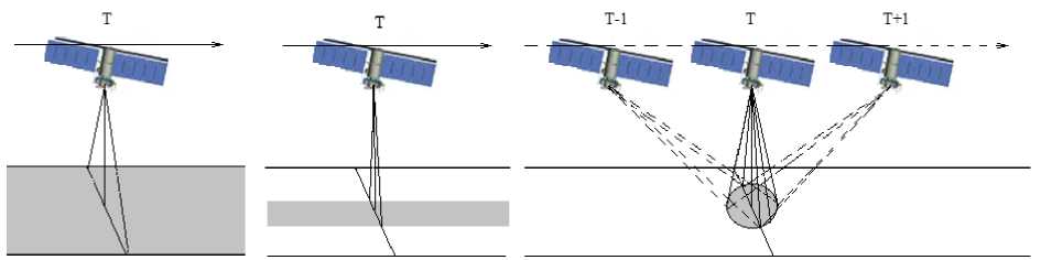
The difficulty of using the wideband mode along the route (survey mode) (Fig. 1, а ) is caused by azimuthal ambiguity and geometric distortions caused by the radial velocity in the beams with errors in the orientation of the small spacecraft and, especially, when working in the orbital coordinate system, and also consumption during shooting of increased power from buffer batteries. The best options for eliminating the orientation error are the use of a phased antenna array with electronic scanning and digital processing of the received signals [10; eleven]. The task of digital processing will require a transition to programmable logic integrated circuits.
With continuous shooting, it is possible to process the entire azimuthal radiation pattern of the antenna (resolution up to δХ ≥ D r /2) and the wideband mode can be reduced by the position of the narrow band, as shown in Fig. 1 b . The acquisition band is within the SAR swath.
б
Рис. 1. Проекция площади при различных режимах обзора: а – широкополосный режим; б – узкополосный режим; в – прожекторный режим
Fig. 1. Projection of the area in different viewing modes: a – wideband mode; b – narrowband mode; c – spotlight mode
In the case when a wide capture area is required and the conditions of unambiguity are not satisfied, then the view area is scanned with several partial beams in the scansar survey mode [12] at the cost of reducing the information processing time. Review is carried out in frames alternately with beam switching.
Spotlight mode is implemented when high resolution is required, and the signal duration is limited by the antenna irradiation zone in azimuth (Fig. 1, c ). This mode is carried out by keeping the antenna pattern in the captured frame during the passage of the small spacecraft [13; 14].
Optimization of signal processing in multi-position spotlight mode
A space multi-position system should consist only of transceivers located on spacecraft of various space systems (transmitters (TM) – spacecraft (SC) of a communication system, navigation spacecraft, telecommunication spacecraft, etc., receivers(R) - research small spacecraft (SSC)), capable of carrying out joint processing from objects capable of reflecting the radio signal. Figure 2 shows a space multiposition system operating in the searchlight mode, where the illumination function is performed by the transmitter of the spacecraft of the low-orbit communication system (TM SC-1), the transmitter of the spacecraft of the communication system in elliptical orbit (TM SC-2) and the transmitter of the spacecraft of the geostationary communication system (TM SC-3), and the reception of the reflected signal is performed by the grouping or "swarm" of the SS (R SSC-1, R SSC-2, R SSC-3). The implementation of a multi-position SAR system is the relative movement of radars and scattering points within the required irradiated area.
According to fig. 2, emitters will introduce a Doppler shift into the reflected signal, which will have a maximum positive value when it first enters the receive beam and a maximum negative value when it exits the spotlight. The nature of the change in the Doppler shift for any point will be the same in time. The Doppler process linearly modulates the frequency of the reflected signal so that its shape matches with the reflected signal that is received after the transmission of the original pulse.
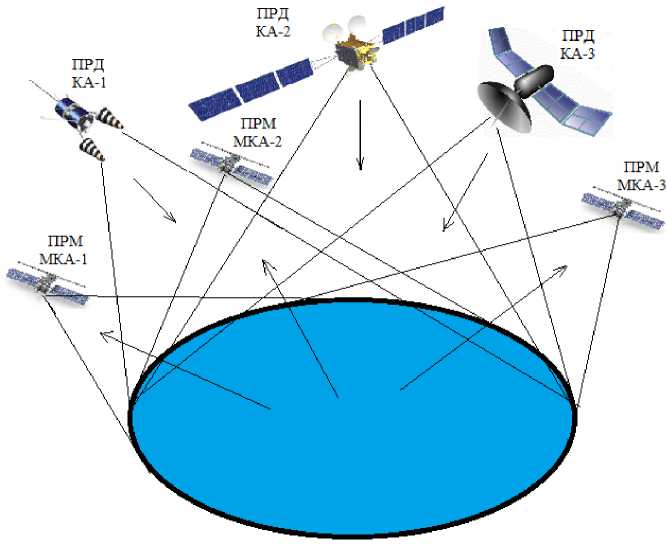
Рис. 2. Многопозиционная система с прожекторным режимом
Fig. 2. Multi-position spotlight system
The maximum synthetic aperture length is the distance traversed by the SSC for which a single point remains within the field of view of the real beam. Thereby one of the requirements for space systems for coverage modes is fulfilled, providing a “passless” viewing mode.
One of the main tasks in creating such a system is the development of methods for joint processing of the observed fields [15–18], which will allow achieving the maximum quality of the data obtained.
At present, a large number of "theoretical" works have been carried out, the task of which is to globally monitor the state of the sea surface, including the movement of atmospheric cyclones (storm waves). For radar illumination of the earth's surface, satellite radio navigation systems (GNSS) [19– 28] or geostationary telecommunication spacecraft [29; 30].
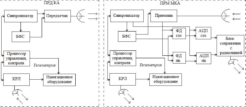
A generalized block diagram of the proposed multi-position SAR with one spacecraft - transmitter (high-orbit or low-orbit communication satellites, as well as navigation satellites), one small spacecraft - a receiver and a ground complex is shown in fig. 3.
The space radar complex of any space system includes an antenna that transmits on a spacecraft illumination (TM SC) and a receiving antenna on SSC with SAR (R SC), a signal conditioning unit (SCU), a synchronizer, a receiver with outputs to a phase detector (PD) of sine and cosine quadrature channels, an analog-to-digital converter (ADC) of quadrature channels, an interface unit with a radio transmission line data, command and control processor, navigation equipment, command and telemetry radio link (CTRL) and data radio link (DRL).
The ground complex includes a command-telemetric radio link, an DRL receiver, an archive of the information component, a device for synthesizing a digital radio hologram (DRH), a device for normalizing, radiometric and geometric image correction, geographic coordinates, and a workplace for processing information for the task.
Technological repeatability determines a relatively low cost of creating and deploying such a multiposition system, and the creation of universal information processing software will make it possible to quickly make adjustments to the system operation algorithms.
Наземный комплекс управления
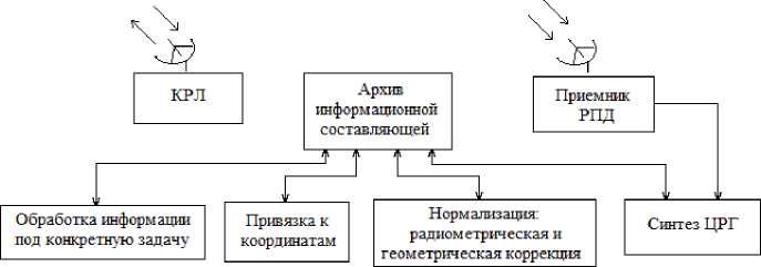
Рис. 3. Структурная схема многопозиционного РСА
Fig. 3. Structural diagram of a multi-position SAR
In the presented multi-position SAR using scientific research for small satellites, radar sounding methods can be used, which are divided into three main groupes:
-
1) methods for studying fluctuations in the amplitude of the backscattered (or reflected) signal, which are based on the relationship of the spatial characteristics of sea waves with the structure that envelopes intra-period fluctuations and the elevation dependences of the specific effective scattering area of the sea surface on the intensity of wind waves;
-
2) methods based on the analysis of Doppler frequency shifts of the signal caused by the presence of radial projections of the velocities of single reflectors relative to the radar;
-
3) methods based on measurements of time delays and shifts of elements of the reflected signal.
These methods are based on the representation of the distributed reflection coefficient of objects included in the reflected/scattered signal equation as a functionally determined or stochastic spatial process. Further optimization of the method of forming a radar image in systems of remote sensing of the sea surface can be based on two main models of signals reflected from the surface - stochastic and functionally deterministic.
Conclusion
A multi-station SAR system based on the SSC will be one of the most powerful sea surface imaging systems in the future, however, there are difficulties in converting the raw data from the SAR into an understandable form. One of the solutions to this problem is digital correlation and a flexible approach that will allow you to accurately perceive the appearance of the image. The presented scheme for obtaining and processing information can become the basis for creating various options for quasi-optimal algorithms that are applicable in the absence of the necessary a priori information or when it is necessary to provide real-time measurements. The use of small satellites for radar sounding of the sea surface as part of a multi-position SAR system will make it possible to quickly adjust the algorithms for processing radar images and, in the future, to carry out complex processing of radar data received from meteorological satellites and observation systems in the optical bands.
References Small satellites for sea surface sounding
- Kartsan I. N., Efremova S. V., Khrapunova V. V., Tolstopiatov M. I. Choice of optimal multi-version software for a small satellite ground-based control and command complex. IOP Conference Series: Materials Science and Engineering. 2018, Vol. 450(2), P. 022015.
- Kartsan I. N., Efremova S. V. [Distributed control of university small spacecraft] Мaterialy V Mezhdunar. nauch. konf. “Aktual'nyye problemy aviatsii i kosmonavtiki” [Materials V Intern. Scientific. Conf “Topical Issues in Aeronautics and Astronautics”]. Krasnoyarsk, 2019. P. 47–48. (In Russ.).
- Kartsan I. N. [Ground control complex for small spacecraft]. Vestnik SibGAU. 2009, No. 3 (24), P. 89–92 (In Russ.).
- Satellite Hydrophysics. Ed. by M. I. Stern. Мoscow, Nauka Publ., 1983, 253 p.
- Ruffini G., Soulat F., Caparrini M., Germain O., Martin-Neira M. The eddy experiment: accurate GNSS-R ocean altimetry from low altitude aircraft. Geophys. Res. Lett. 2004, No. 31(2), P. 2306.
- Martin-Neira M., D’Addio S., Buck C., Floury N., Prieto-Cerdeira R. The PARIS ocean altime-ter in-orbit demonstrator. IEEE Trans. Geosci. Remote Sens. 2011, No. 49(6), P. 2209–2237.
- Neronsky L. B., Mikhailov V. F., Bragin I. V. Microwave equipment for remote sensing of the Earth surface and atmosphere. Radar with synthesized aperture antenna. Spb., SPbGUAP Publ., 1999, Part 2, 220 p.
- Klimenko N. N., Zanin K. A. New generation of spacecraft for maritime surveillance. Air and Space Sphere. 2019, No. 2, P. 72–82.
- Klimenko N. N. Modern low-orbit spacecraft for geolocation and identification of radio emis-sion sources. Air and Space Sphere. 2018, No. 2, P. 48–57.
- Tyapkin V. N., Kartsan I. N., Dmitriev D. D., Efremova S. V. Algorithms for adaptive process-ing of signals in a flat phased antenna array. International Siberian Conference on Controland Com-munications (29–30 June 2017). Astana, Kazakhstan, 2017. P. 7998452.
- Kartsan I. N., Goncharov A. E., Zelenkov P. V., Kovalev I. V., Fateev Y. L., Tyapkin V. N., Dmitriev D. D. Applying filtering for determining the angular orientation of spinning objects during inter-ference. IOP Conference Series: Materials Science and Engineering. 2016, No. 155 (1), P. 012020.
- Turuk V. E., Verba V. S. Golovanova, M. V. SAR Strizh for small spacecraft Komandor-E. Modern problems of Earth remote sensing from space. 2017, Vol. 14, No. 5, P. 69–83.
- Turuk V., Verba V., Golovanova M., Neronskiy L., Zaitsev S., Tolstov E. Russian Spaceborne Synthetic Aper-ture Radar “Strizh” for Light Satellites of “Condor-E” type. Proc. EUSAR’2016. Hamburg, Germany. 2016. P. 947–952.
- Afanasyev I. Zorky “Condor”. Novosti kosmonavtiki. 2013. № 8. pp. 46-50.
- Ksendzuk A. V., Fateyev V. F., Popov S. A. Method of signal processing in space multiposi-tion radar systems with synthesis of antenna aperture. Izvestiya vysokikh izuchenii “Instrument-making” 2009, No. 4(52), P. 28–34.
- Falkofich S. E., Volosyuk V. K., Gorbunenko O. A. Radiotechnical systems of remote sensing. Kharkov, KAI Publ., 2002, 157 p.
- Ksendzuk A. V., Volosyuk V. K., Sologub N. S. Modeling SAR primary and secondary pro-cessing algorithms. Estimating quality of the processing techniques. 5-th European Conference on Synthetic Aperture Radar EUSAR 2004. Ulm, Germany. 2004. Vol. 2, P. 1013–1016.
- Ksendzuk A. V., Gerasimov P. A. Inverse passive synthetic aperture radar. Radio industry (Russia), 2016, Vol. 26(1), P. 33–37. (In Russ.).
- Zavorotny V., Masters D., Gasiewski A., Bartram B., Katzberg S., Axelrad P., Zamora R. Sea-sonal polarimetric measurements of soil moisture using tower-based GPS bistatic radar. IGARSS 2003. 2003 IEEE International Geoscience and Remote Sensing Symposium (21-25 July 2003). Toulouse, France, 2003. vol.2, pp. 781–783.
- Lowe S. T., Kroger P. M., Franklin G. W., LaBrecque J. L., Lerma J., Lough M. F., Marcin M.R., Spitzmesser D.J., Young L. E. A delay Doppler-mapping receiver system for GPS-reflection remote sensing. IEEE Journal of Selected Topics in Applied Earth Observations and Remote Sensing. 2003, Vol. 40(55), P. 1150–1163.
- Zavorotny V., Larson K.M., Braun J., Small E. E., Gutmann E., Bilich A. A physical model for GPS multipath caused by land reflections: Toward bare soil moisture retrievals. IEEE Journal of Se-lected Topics in Applied Earth Observations and Remote Sensing,. 2010,Vol. 3(1), P. 100–110.
- Gutmann E., Larson K. M., Williams M., Nievinski F. G., Zavorotny V. Snow measurement by GPS interferometric reflectometry: An evaluation at niwot ridge, Colorado. Hydrol. Process. 2011, Vol. 26(19), P. 2951–2961.
- Voronovich A.G. Non-local small-slope approximation for wave scattering from rough surfac-es. Waves in Random Media. 1996, Vol. 6(2), P. 151–167.
- Voronovich A.G. Small-slope approximation for electro-magnetic wave scattering at a rough interface of two dielectric half-spaces. Waves Random Media, 1994. Vol. 4(3), pp. 337–367.
- Soiguine A. Scattering of geometric algebra wave functions and collapse in measurements. Journal of Applied Mathematics and Physics, 2020. Vol. 8, pp. 1838-1844.
- Johnson J.T. A study of ocean-like surface thermal emission and reflection using Voronovich’s small slope approximation. IEEE Trans. Geosci. Remote Sensing, 2005. Vol. 43(2), pp. 306–314.
- Voronovich A.G., Zavorotny V.U. Ocean-scattered polarized bistatic radar signals modeled with small-slope approximation. IEEE Int. Geoscience Remote Sensing Symp., 2012. pp. 3415–3418.
- Zavorotny V. U., Voronovich A. G. Bistatic GPS signal reflections at various polarizations from rough land surface with moisture content. IEEE Int. Geoscience Remote Sensing Symp. 2000, Vol. 7, P. 2852–2854.
- Pereslegin S. V., Levchenko D. G., Karpov I. O. The vibration wave on the water surface: par-ametric excitation and radar observation. Fundamentalnaya i Prikladnaya Gidrofizika. 2021, Vol. 14(2), P. 39–53. Doi:10.7868/S2073667321020040.
- Pereslegin S. V., Karpov I. O., Khalikov Z. A., Ermakov R. V., Mussiniants T. G. The forming of sea surface velocity images from stationary, airborne and spaceborne platforms. Fundamentalnaya i Prikladnaya Gidrofizika. 2019, Vol. 12(1), P. 21–29. Doi:10.7868/S2073667319010039.
