Современные методы мониторинга ветровой эрозии почв

Автор: Романовская А.Ю., Савин И.Ю.
Журнал: Бюллетень Почвенного института им. В.В. Докучаева @byulleten-esoil
Рубрика: Статьи
Статья в выпуске: 104, 2020 года.
Бесплатный доступ
В статье приведен обзор научной литературы в области существующих методов мониторинга ветровой эрозии почв: визуальной оценки, микронивелирования, фотограмметрического, Cs137 и дистанционных методов с последующим моделированием. Приводится краткая характеристика каждого метода, преимущества и недостатки, а также условия и ограничения их применения. При выборе методанеобходимо учитывать условия проведения мониторинга, площадь рассматриваемой территории и масштаб проведения исследований, временные рамки, финансовые и трудовые ресурсы. Установлено, что наиболее актуальными, экономически оправданными и перспективными, особенно на больших территориях, являются методы дистанционного зондирования, позволяющие проводить мониторинг в различных масштабах, и не только оценивать эрозионную активность, но и прогнозировать ее, таким образом, предоставляя иинформацию для принятия верных, оперативных и своевременных хозяйственноэкономических решений, направленных как на борьбу с ветровой эрозией и устранение последствий, так и на организацию превентивных мер. Для повышения эффективности этих методов также необходимо создавать базы данных, расширять и накапливать почвенную информацию, которая позволяет верифицировать, уточнять, обрабатывать и калибровать полученные спутниковые данные. В литературе в подавляющем большинстве случаев речь идет о дешифрировании ветровой эрозии в пустынных и полупустынных зонах. Также практически отсутствуют исследования о переносе химических веществ с микрочастицами в результате ветровой эрозии. Как в России, так и за рубежом предпринимаются попытки моделирования эрозии почв, но качество моделей сильно ограниченно недостатком полевых данных, необходимых для их калибровки и верификации, которые можно получить наземными методами, пречисленными выше. Выявление эродированных почв в стране до сих пор осуществляется наземными методами. Однако полевые исследования могут проводиться только на очень ограниченной территории, на немногих ключевых участках, и их проведение затруднительно на активно используемых сельскохозяйственных землях.
Дефляция почв, спутниковый мониторинг, деградация почв, методы исследования почв
Короткий адрес: https://sciup.org/143173087
IDR: 143173087 | УДК: 631.474 | DOI: 10.19047/0136-1694-2020-104-110-157
Modern techniques for monitoring wind soil erosion
The article presents a scientific literature review in the field of modern methods of monitoring wind erosion of soils such as: visual indicators of erosion, erosion bridge, close-range photogrammetry, cesium-137 and remote sensing cover. The brief description of each method, advantages and disadvantages, conditions and limitations of their applicability are given. When choosing the method, it is necessary to take into account the monitoring conditions, the area of the territory under consideration and the scale of research, time frames, financial and labor resources. It has been established that the most relevant, economically justified and promising, especially on large territories, are the remote sensing methods, which allow monitoring on different scales, and not only estimating the erosion activity, but also predicting it, thus providing the parties concerned with the necessary information for making right, prompt and timely economic decisions, aimed both at combating wind erosion and elimination of its consequences, and for organizing preventive measures as well. To improve the effectiveness of these methods it is also necessary to create databases, expand and accumulate soil information that can help verify, refine, process and calibrate the satellite data obtained. In order to understand aeolian processes and dust particle transport mechanisms one should create integrated methods that include remote sensing data, meteorological data, on the basis of which the improved models and maps would be developed, and erosion processes would be predicted. The scientific literature is mostly devoted to the interpretation of wind erosion in arid and semi-arid zones. The possibility of satellite monitoring of soil erosion in arable fields remains poorly studied. There are also practically no research results available on the transport of chemicals with micro-particles due to wind erosion. Both in Russia and abroad the attempts are made in soil erosion modelling, but the quality of the models is very limited by the lack of field data required for their calibration and verification. Eroded soils in the country are still identified using ground-based methods. However, field studies can only be conducted in a very limited area, in a few key points, and as a matter of fact it is quite complicated to conduct field studies on actively used agricultural lands.
Текст научной статьи Современные методы мониторинга ветровой эрозии почв
Под эрозией почвы в настоящее время понимают совокупность взаимосвязанных процессов отрыва, переноса и отложения почвы поверхностным стоком временных водных потоков и вет- ром. Явление ветровой эрозии почвы зарождается на границе твердой и газообразной сред (почвы и воздуха), развивается в прилегающем к Земле слое атмосферы и завершается на земной, водной или почвенной поверхности (Гендугов, Глазунов, 2007; Duniway et al., 2019).
Изучение эрозии почв, ее причин и следствий, а также мероприятий по ее ликвидации имеет большое народнохозяйственное и научное значение. Эрозия почв – это постоянные, нередко разрушительные процессы, которые существенно усиливаются в результате деятельности человека и приносят большой ущерб народному хозяйству (Кузнецов, Глазунов, 2020) .
Прежде всего затраты связаны со снижением объемов получаемой продукции и сырья, с восполнением потерь питательных веществ путем внесения повышенных доз удобрений, с увеличением стоимости содержания дорог, дамб и другой инфраструктуры, со снижением водоудерживающей способности почвы, что, в свою очередь, приводит к повышению оросительных норм, и, следовательно, сопутствующих издержек, и, наконец, существенных затрат требуют и сами противоэрозионные мероприятия. Кроме того, ветровая эрозия снижает рекреационный потенциал территории вследствие ухудшения качества воды и воздуха, сведения мест обитания диких животных. Несмотря на то, что эрозия – это важный естественный процесс, когда он дополнительно усиливается деятельностью человека, то может оказывать существенное влияние на продуктивность и характер использования земель (Гендугов, Глазунов, 2007; Ypsilantis, 2011; Duniway et al., 2019; Webb et al., 2020) . В наибольшей степени эрозии подвержены почвы наиболее густонаселенных регионов. Это свидетельствует в пользу общепринятого представления о том, что в местах обитания человека эрозия имеет в основном антропогенный характер.
Механизмы влияния ветровой эрозии на почву весьма многообразны. Это и снижение плодородия эродированных почв, и уменьшение площади пашни в результате надвигания песков, и загрязнение почв сельскохозяйственных угодий вредными веществами, в том числе токсичными солями, приносимыми ветром с поверхности солончаков и отвалов горных пород, а также снижение фотосинтеза в результате загрязнения листовой поверхности посевов пылью. Кроме того, ветровая эрозия почвы является главной причиной наполнения воздуха пылью, причем масштабы поступления почвенной пыли столь велики, что она начинает влиять на тепловой баланс планеты (Гендугов, Глазунов, 2007).
Эрозия приводит к потере углерода почвой, во-первых, в результате механического удаления из эродируемой почвы, во-вторых, в ходе ускоренной минерализации, вызванной эрозией, как в эродированной почве, так и в наносной. Процессы, приводящие к этому, требуют углубленного изучения, но уже теперь не подлежит сомнению, что одним из немногих возможных способов изъятия избытка углерода из атмосферы является запасание его в виде специфического органического вещества почвы (Minasny et al., 2017) .
Почва – основа среды обитания человека, и эрозия приводит к нарушению этой функции почв. В частности, обыкновенная почвенная пыль, поднимаемая ветром, вызывает увеличение заболеваемости астмой. При большом содержании почвенной пыли в воздухе может быть полностью парализована жизнь огромного мегалополиса. Ситуация столь серьезна, что во многих странах законодательно вводятся пределы допустимого содержания пыли в атмосфере.
Кроме того, пыль может служить причиной возникновения эпидемий, так как содержит повышенное количество спороносных аэробных бактерий. Еще большую опасность несет радиоактивная пыль, источниками которой являются эродируемые ветром почвы загрязненных территорий, а также золоотвалы теплоэлектростанций, работающих на углях, содержащих радиоактивные элементы и тяжелые металлы.
Частота и масштабы проявления ветровой эрозии почвы, которые стали глобальными, а также темпы и тенденции ее распространения имеют угрожающий характер. Об этом свидетельствуют многочисленные материалы последних международных форумов ученых и общественности, организованных Докучаевским обществом почвоведов, Международным обществом почвоведов (ISSS), Международной организацией мелиорации почв (ISCO), Европейским обществом охраны почв (ESSC), Организацией охраны почв и вод (SWCO).
Эрозии в мире подвержены почвы на площади в 1.643 млрд га, из них в чрезмерной степени – на площади в 250 млн га. Водная эрозия распространена на площади в 1 094 млн га, а ветровая – на площади в 549 млн га (GLASOD, 1990) (https://www.isric.org/projects/global-assessment-human-induced-soil- degradation-glasod) . Ареалы почв, пораженных этими двумя видами эрозии, совпадают лишь частично. Согласно прямым измерениям со спутника, пыльные бури, как крайнее проявление ветровой эрозии почвы, возникают во всех почвенно-климатических поясах, в том числе в арктическом, но наиболее часто и устойчиво они повторяются в Северном полушарии, в так называемом пыльном поясе, протянувшемся от западных окраин Северной Африки, через Ближний и Средний Восток, Центральную и Южную Азию в Китай.
Согласно расчетам, в течение двух последних веков эрозия уничтожила в мире почти 2 млрд га пашни. Для сравнения – сейчас сельскохозяйственные земли обрабатываются на площади 1 .5 млрд га (https://agrovesti.net/lib/tech/reclamation-tech/eroziya-pochv- prichiny-vidy-posledstviya-metody-predotvrashcheniya.html) .
Ветровая эрозия может нанести непоправимый вред, как за длительное время, так и всего за несколько часов. Пыльные (черные) бури довольно быстро уничтожают верхний слой почвы, унося его порой за многие сотни километров. Порой такая пыль, оседая, засыпает целые водоемы. Можно привести пример из 50-х годов прошлого века. Тогда во время освоения целины в степях Казахстана и западной части Алтайского края была использованная отвальный вспашка земли. После посева началась засуха, а затем на территорию с Запада пришел сильный ветер. Он унес значительную часть плодородного слоя. Пыль казахстанских и алтайских степей оседала даже в Красноярском крае (https://agrovesti.net/lib/tech/reclamation-tech/eroziya-pochv-prichiny- vidy-posledstviya-metody-predotvrashcheniya.html) .
В России ветровая эрозия проявляется в основном в определенных границах. По северу – это неправильной формы линия от Воронежа в направлении на Восток. Граница идет через Самару, Челябинск, Петрозаводск, Омск. Далее – к Новосибирску и затем в Восточную Сибирь, через Хакасию, Бурятию, Туву, Читинскую область. Из-за этого на землях сельскохозяйственного назначения, расположенных южнее, применяются меры для защиты от ветровой эрозии. Высокие риски для ветровой эрозии присутствуют в Поволжье, на Северном Кавказе, на Урале, в Сибири. В зоне риска находится площадь, превышающая 45 млн га, в том числе 38.7 млн га – это пашня (https://agrovesti.net/lib/tech/reclamation-tech/eroziya-pochv-prichiny-vidy-posledstviya-metody- predotvrashcheniya.html). Таким образом, основными дефляционно опасными очагами в стране являются степные и полупустынные зоны, особенно в регионах с высокой долей пахотных земель (Ларионов, 1993).
Ежегодно с пахотных склонов страны из-за водной и ветровой эрозии сносится свыше 500 млн т плодородной части почв. В результате этих процессов недобор зерна по стране оценивается в 15.8 млн т в год. Общий ущерб от водной и ветровой эрозии в России составляет ежегодно более 9.7 млрд. долларов (Иванов и др., 2016) .
Поэтому мониторинг эродированных почв России представляет собой важную и неотложную общегосударственную проблему. С научной точки зрения процесс ветрового массопереноса с пахотных земель до сих пор очень слабо изучен. География этих явлений определена лишь в самом общем виде, а перенос химических веществ с микрочастицами с полей и их влияние на плодородие почв зон оседания частиц и их экологическое состояние практически не изучены (Научные основы…, 2013) .
В последние десятилетия появились новые технические возможности для исследования ветровой эрозии. Так, при регистрации и отслеживании пыли, поднятой в воздух во время обработки почвы или в результате эрозии, стали применять лидары, солнечные фотометры, счетчики фотонов; при изучении переноса почвы ветром в приземном слое – пьезо- и мембранные датчики с высокой собственной частотой измерения, изокинетические пылеуловители, при физическом моделировании ветровой эрозии – усовершенствованные полевые и лабораторные аэродинамические установки (Гендугов, Глазунов, 2007; Кузнецов, Глазунов, 2020). Одновременно с развитием экспериментальных методов изучения ветровой эрозии совершенствовались системы дистанционного зондирования на основе аэрокосмической съемки, что привело к накоплению огромного экспериментального материала, позволяющего анализировать явление ветровой эрозии почвы во всей его полноте, от стадии выдувания до стадии аккумуляции. Однако о наличии такого рода проектов, посвященных сопряженному исследованию полномасштабного единичного явления ветровой эрозии почвы на микро-, мезо- и макроуровнях, неизвестно.
ТРАДИЦИОННЫЕ МЕТОДЫ МОНИТОРИНГА ВЕТРОВОЙ ЭРОЗИИ ПОЧВ
Начало научному подходу к изучению ветровой эрозии почв и разработке противоэрозионных мероприятий положено трудами классиков почвоведения: В.В. Докучаева, П.А. Костычева, Н.М. Сибирцева, В.Р. Вильямса, – их сотрудников и последователей, которые уделяли внимание ветровой эрозии в первую очередь в качестве фактора образования и преобразования почв, а также трудами великих исследователей Центральной Азии: Н.М. Пржевальского, Н.Ф. Дубровина, В.И. Роборовского, П.К. Козлова, Г.Е. Грум-Гржимайло, М.В. Певцова, Г.Н. Потанина, В.А. Обручева, которые исследовали физические, почвоведческие, геологические и географические аспекты ветровой эрозии (Гендугов, Глазунов, 2007). На основе преимущественно описательного, сравнительногеографического метода исследований они получили первые, не потерявшие своего значения до сих пор, сведения о причинах, интенсивности и масштабах проявления ветровой эрозии почв и способах ее предупреждения. Расширение методической базы, обусловленное применением стационарного и сравнительноаналитического методов исследования, позволило углубить качественные представления о механизмах явления ветровой эрозии почв, получить количественные оценки ее распространения и степени опасности, положить начало разработке противоэрозионных мероприятий на научной основе. Дальнейший качественный и количественный рост исследований по ветровой эрозии почв связан с развитием и применением методов моделирования – физического, математического, численного. Начало экспериментальным методам изучения механизмов ветровой эрозии почв было положено работами видного геолога Н.А. Соколова в конце XIX в. Наиболее содержательные результаты при изучении механизмов ветровой эрозии были получены во второй половине прошлого века А.И. Знаменским, Г.И. Васильевым, Д.С. Булгаковым, Л.Н. Гавриленко, А.С. Калиниченко и др. с применением инструментальных методов, основанных на измерении переноса почвенных частиц ветром во время пыльных бурь в полевых условиях. Для выяснения механизмов отрыва почвенных частиц ветром потребовалась разработка методов физического моделирования на основе аэродинамических труб (Гендугов, Глазунов, 2007).
Ниже приводится краткая характеристика основных традиционных методов оценки и мониторинга ветровой эрозии.
Визуальная оценка
В 1967 г. в США впервые была разработана методика оценки эрозионного состояния земель площадью 160 млн акров в течение последующих 5–10 лет. Важно отметить, что на тот момент не было еще накоплено количественных показателей, позволяющих оценить эрозионную активность в конкретный момент. С этой целью была разработана Классификация эрозионного состояния (The Erosion Condition Classification System) (Clark, 1980) , основанная на свойствах поверхности почвы, которые исследователь может оценить в полевых условиях и которые можно представить в цифровом выражении и в дальнейшем использовать в качестве основы для выделения пяти эрозионных классов. Эти цифровые величины, характеризующие классы эрозионного состояния, были названы “факторами поверхности почвы” (Soil Surface Factors – SSF) и изменялись в пределах от 1 до 100 (Clark, 1980; Ypsilantis, 2011) . Визуальная оценка сводится к тому, что рассматриваются определенные почвенные свойства: эрозионное основание, передвижение поверхностных частиц, отложения, сила порывов ветра в баллах и др. Некоторые из этих показателей до сих пор учитываются при оценке состояния земель (Pellant et al., 2005; Ypsilantis, 2011) . Для оценки используется методика из соответствующих технических справочников, учитывается местоположение, в том числе и экологический район, фактические значения показателей эрозии сравниваются с референсными значениями, отличия записываются в соответствующий документ.
Преимущества и недостатки
Основные преимущества метода визуальной оценки: 1) это относительно быстрый процесс; 2) наблюдения можно сделать при полевом обследовании; 3) могут быть выявлены потенциальные эрозионные проблемы, требующие осуществления мониторинга в каком-то конкретном месте (проблемные локации).
К основным недостаткам использования метода визуальной оценки относятся: 1) субъективность, основанная на мнении и оценке эксперта; 2) количественные оценки (баллы) могут различаться у разных экспертов без соответствующей подготовки; 3) оценки могут варьировать в зависимости от времени наблюдения относительно момента, когда разыгралась буря; 4) экологический район должен быть известен, для него требуется соответствующий технический справочник с референсными значениями и методикой; 5) эта методика может быть выполнена только очень опытным, грамотным и знающим человеком.
Анализ данных
Отличия визуально оцениваемых параметров от их референсных значений фиксируются в специально предусмотренных формах. Отличия от эталонных значений определяются для каждого из этих показателей, после чего высчитывается итоговый балл и приводится характеристика стабильности рассматриваемой территории, ее гидрологическая функциональность и биологическая целостность.
Эрозионный мост (метод шпилек)
Эрозионный мост – это простой в эксплуатации, функциональный, легкий и недорогой инструмент для оценки ветровой эрозии в полевых условиях. Он состоит из алюминиевой перекладины (или строительного уровня) длиной в 4 фута (приблизительно 1.2 м), который устанавливается на опорные стойки, представляющие собой своего рода реперы для микропрофилирования поверхности почвы под ними. Эта конструкция остается в поле на весь период мониторинга (Shakesby, 1993; Ypsilantis, 2011). Расстояние от уровня до поверхности почвы измеряется в 10 фиксированных точках, расположенных равномерно по всей длине каждого уровня, с помощью специальных шпилей, которые опускаются до уровня поверхности земли. Эти измерения используются для расчета средних изменений уровня поверхности почвы (рис. 1).
Места установки эрозионных мостов и их ориентация выбираются случайно в пределах изучаемой территории (Blaney, Warrington, 1983) . Каждая локация должна быть точно зафиксирована с помощью GPS так, чтобы ее можно было рассматривать как точку ввода данных. Считается, что понижение уровня почвы на 1 миллиметр соответствует выдуванию 5 тонн почвы с акра (0.405 га). Повторные измерения на каждом шпиле проводятся при каждом осмотре и регистрации данных. Эти измерения свидетельствуют об изменении уровня поверхности почвы, о выдувании верхнего слоя или, наоборот, аккумуляции (Ypsilantis, 2011) .
В России подобный метод учета изменения уровня почвенной поверхности называется методом шпилек. Шпилька представляет собой тонкий металлический стержень с нанесенными на нем делениями. Шпильку погружают в почву до нулевой отметки. Изменение уровня поверхности почвы возле шпильки позволяет судить о величине наноса почвы или о величине потерь. Метод шпилек применяют и при изучении водной эрозии, и при изучении дефляции в течение длительного времени. В зимний период возможно движение шпильки в вертикальном направлении вследствие морозного пучения почвы, которое можно исключить, защитив шпильку обсадной трубой (Кузнецов, Глазунов, 2020) .
Существует много методов измерения уровня почвенной поверхности как индикатора эродированности почв. Наиболее широко применяемый (в силу своей простоты и доступности) – метод микронивелирования. Он заключается в устройстве на исследуемой площадке жестко фиксированных опор, на которые по мере наступления сроков измерений устанавливают на постоянной высоте от поверхности почвы металлическую рейку, по которой свободно перемещается тележка с прикрепленной к ней мерной иглой. Мерная игла снабжена нониусом и позволяет измерять вертикальную координату точки на поверхности почвы с точностью до 0.1 мм. Горизонтальную координату определяют с точностью до 1 мм (по линейке, укрепленной на направляющей рейке). Имея два профиля поверхности почвы, полученные в одном створе в разное время, можно определить слой почвы, который утрачен вследствие эрозии за это время. Метод пригоден для работы с почвой в состоянии близком к равновесному, при котором плотность почвы приблизилась к некоторой постоянной для данного угодья и сезона величине. В случае рыхлой почвы возможны ошибки в определении величины смыва, обусловленные усадкой почвы (Кузнецов, Глазунов, 2020).
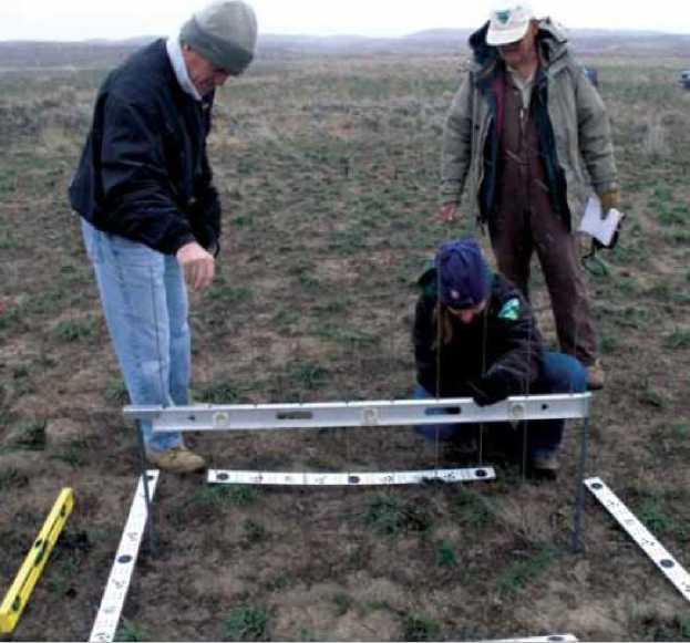
Рис. 1. Эрозионный мост, используемый для количественной оценки интенсивности ветровой эрозии на выгоревшей территории, через 2 года после пожара, штат Айдахо (США) (Ypsilantis, 2011) .
Fig. 1. Erosion bridge used for quantitative assessment of wind erosion intensity in a burned-out area, 2 years after the fire, Idaho (USA) (Ypsilantis, 2011) .
Преимущества и недостатки
Преимущества эрозионного моста состоят в том, что это недорогой, быстрый, беспристрастный метод оценки эрозионной активности. Однако учетные площадки и их ориентацию необходимо выбирать случайным образом, чтобы избежать систематической ошибки.
К недостаткам можно отнести то, что уровень может быть смещен или сдвинут людьми, техникой или животными, а также в результате вспучивания грунта при промерзании, что делает измерения бессмысленными. Кроме того, шпили довольно тонкие и в некоторой степени гибкие, поэтому если при измерении они не попадают в одну и ту же точку, то могут быть получены неточные значения. Также сама исследуемая территория и количество учетных площадок довольно малы. Этим методом практически невозможно получить данные об эродированности почв на больших территориях.
Анализ данных
Полученные измерения используются для расчета средней величины изменения уровня поверхности почвы, которую можно перевести в интенсивность эрозии, указав временной интервал, в течение которого это изменение произошло. В дальнейшем можно использовать t-критерий Стьюдента для расчета среднего значения и доверительного интервала, потом сравнивать полученные величины (Blaney, Warrington, 1983; Ypsilantis, 2011) .
Приблизительную оценку величины потерь почвы от дефляции можно произвести по измерению глубины залегания семян. Глубина заделки семян известна, и по разности глубин можно судить о величине потерянного слоя почвы. Мощность сдутого слоя почвы можно оценить и по отдельным почвенным глыбам-останцам, которые встречаются в плохо разделанном пахотном слое (Соболев, 1948). В случае щебнистой почвы мощность сдутого слоя почвы определяется по накоплению щебня на поверхности. Для этой цели предлагается с учетных площадок размером 0.5 х 0.5 м2 собрать двухсантиметровый поверхностный слой почвы и с помощью сита с размером ячеек 2 мм отделить мелкозем от камней, а затем взвесить его (Долгилевич, 1958). После этого необходимо определить концентрацию камней в пахотном слое почвы с помощью того же сита. Зная концентрацию камней в почве и количество камней, накопившихся на учетной площадке, можно, составив пропорцию, рассчитать количество мелкозема, вмещавшего это количество камней до начала дефляции.
Фотограмметрический метод (наземная фотограмметрия)
Ближняя фотограмметрия – отличный метод получения детальной информации об эрозии на площадках размером от 1 м2 до всего склона. Программное обеспечение позволяет создавать цифровую модель земной поверхности с густотой сетки в 1–2 мм и обнаруживать изменения уровня поверхности почвы с субмиллиметровой точностью на площадках меньшего размера. Этот метод особенно эффективен для мониторинга эрозии на участках свободных от растительности, таких как дороги, строительные площадки и дороги, накатанные в диких местах внедорожной техникой. Также этот метод подходит для измерения осадка, который накапливается в специально разработанных и установленных аккумулятивных ловушках, предназначенных для мониторинга эрозии на водосборной площади.
Наземная (ближняя) фотограмметрия представляет собой компиляцию фотографических материалов с их последующей обработкой и подразумевает расстояние между камерой и объектом менее 300 м (Matthews et al., 2014). Цифровая камера требует предварительной калибровки для работы в системе координат x, y и z. Фотограмметрическая калибровка цифровых съемочных камер выполняется с целью определения значений элементов внутреннего ориентирования съемочных камер, включая параметры фотограмметрической дисторсии объектива съемочной камеры. В этом методе фотограмметрическая калибровка цифровых фотокамер производится по снимкам пространственного тест-объекта, где тест-объект представляет собой пространственное поле маркированных точек. Либо в процессе калибровки исследуемый участок снимается под разными углами и с перекрытием, при этом метки совмещения располагают и кодируют по кругу, а затем объект с известными параметрами (размерами) помещается в зоне обзора (Matthews, 2008; Ypsilantis, 2011). Необходимо установить одну (или более) постоянную зафиксированную точку как отметку условного уровня отсчета (своего рода репер) для мониторинга изменения уровня поверхности земли. Для больших территорий требуется большее количество точек – 3 или 4. В качестве опорной точки можно использовать выход коренной породы или вбитый достаточно глубоко в землю металлический стержень, чтобы он оставался стабильным, причем верхушка стержня должна оказаться несколько ниже поверхности земли так, чтобы его не задели и не сместили и чтобы он, в свою очередь, не представлял опасности для людей. Положение опорных точек регистрируется с помощью GPS, при их перемещении для мониторинга на других площадках используется металлоискатель и GPS приемник.
В дальнейшем с помощью компьютера и специального программного обеспечения (например, PhotoModeler® или 3DM Analyst software (ADAM Technology, Australia)) создается цифровая модель поверхности (Matthews, 2008; Ypsilantis et al., 2011) . С помощью отснятых фотографий для исследуемой площади программа создает мозаику, основанную на сложном автоматическом распознавании маркированных точек и схожих параметрах поверхности земли на разных фотографиях. Первичная обработка фотографий может быть выполнена в полевых условиях за несколько минут. Затем трехмерные цифровые модели поверхности анализируются в ArcGIS с использованием ArcMap и ArcScene. Чтобы выявить изменения уровня поверхности почвы первоначально смоделированная сетка поверхности сравнивается с сетками, полученными при последующих исследованиях.
Преимущества и недостатки
Преимущества данного метода состоят в следующем:
-
1) эрозионная активность может быть измерена непосредственно в поле с высоким уровнем точности быстрым и эффективным способом, при этом размер учетных площадок может существенно варьировать (площадью от 1 м2 до площади всего склона);
-
2) невысокая стоимость оборудования для работы в поле;
-
3) для каждой учетной площадки получают тысячи точек ввода данных;
-
4) возможность скрыть опорные точки (стержни) ниже уров-
- ня поверхности земли исключает вероятность их смещения, а также, с точки зрения безопасности, позволяет осуществлять рекреационную активность на исследуемой территории (велосипедные, пешие, конные прогулки и т. д.);
-
5) для всей исследуемой территории строятся подробные карты пространственного распространения почвенной эрозии;
-
6) сами фотографии и совокупность сопряженных данных хранится в электронном виде.
Кроме того, данный метод можно использовать для проверки эрозионных моделей.
К недостаткам можно отнести следующее:
-
1) дорогостоящее на данный момент программное обеспечение, необходимое для обработки данных на учетных площадках большого размера;
-
2) растительность может загораживать поверхность земли, тем самым затрудняя проведение измерений в этой части исследуемой территории;
-
3) в настоящий момент очень мало опытных экспертов и компетентных организаций, способных проводить такого рода мониторинг.
Еще одним недостатком метода является то, что любое перемещение подстилки, камней, других объектов по поверхности земли в процессе обработки данных может интерпретироваться программой как смыв или аккумуляция почвы. Результаты анализа в таком случае могут быть существенно искажены, если подобные точки не удалить из базы данных. Но неправильные (ошибочные) точки ввода данных могут быть удалены из базы данных в процессе обработки.
Анализ данных
ArcGIS (или любой другой пакет ГИС) используется для определения объемов насыпей и выемок в процессе земляных работ, а также выноса верхнего слоя почвы для сетки поверхности в пределах учетной площадки. Общий объем потерь или приноса почвы делится на учетную площадь, чтобы определить потери или аккумуляцию почвы на единицу площади, либо выразить их в тоннах с единицы эродированной площади. Наземная фотограмметрия позволяет определить интенсивность потерь или аккумуляции почвы с точностью до сантиметра на больших площадях (например, для склона в целом) и с точностью до миллиметра для маленьких площадок размером 1 м2.
Программное обеспечение (например, ADAM Technology 3DM), как правило, быстро и эффективно обрабатывает цифровую фотограмметрическую информацию для создания проекта. Метод наземной (ближней) фотограмметрии весьма перспективен и имеет большой потенциал для процесса прямого измерения эрозии, вызванной различными факторами и деятельностью человека.
Использование уловителей пыли
Перечисленные выше методы позволяют оценить потери почвы, т. е. последствия эрозии. Однако они неинформативны в случае изучения механизма эрозии, без понимания которого трудно управлять эрозионными процессами и тем более прогнозировать их появление. В упрощенном виде процессы ветровой эрозии представляют собой движение почвенной массы под действием воздушных потоков. Для того чтобы выявить причины движения этих масс, необходимо уметь измерять это движение – измерять поток твердой фазы (т. е. почвы) в процессе эрозии (Кузнецов, Глазунов, 2020). В настоящее время для этой цели используют всевозможные пыле- и пескоуловители, фильтры, пьезоэлектрические устройства для регистрации перемещения почвенных частиц и т. п. (Кузнецов, Глазунов, 2020). Эти устройства, будучи помещенными в поток, в какой-то степени нарушают его физические характеристики, что отражается на эффективности измерения потока твердой фазы. Чем меньше нарушается взвесенесущий поток в районе приемного отверстия или створа такого прибора или устройства, тем точнее измеряется поток твердой фазы (Кузнецов, Глазунов, 2020). Главная трудность при измерении потока почвенной фазы при дефляции – большая толщина потока, несущего почвенные частички: сплошной пылевой фронт во время пыльных бурь часто имеет толщину несколько сотен метров. Однако основная масса почвы переносится в слое до 1 м, что существенно упрощает задачу и открывает возможности для измерения перено- са почвы ветром с использованием простых и доступных методов (Кузнецов, Глазунов, 2020).
Наиболее широко при изучении дефляционных процессов используют пыле- или пескоуловители, представляющие собой коробку в форме параллелепипеда, одна из граней которого служит приемным отверстием. В качестве примера рассмотрим принципы работы двух пылеуловителей, описанные в работе М.С. Кузнецова, Г.П. Глазунова (2020) :
“…Коробку устанавливают на поверхности почвы так, чтобы приемная грань была перпендикулярна потоку. Для уменьшения сопротивления потоку коробку делают плоской. Так, приемная щель пескоуловителя Бэгнольда имеет высоту 110 см, ширину 1 см. Пылеуловитель крепится на вращающейся оси и снабжается флюгером, что обеспечивает оптимальное положение приемного отверстия относительно потока – плоскость приемного отверстия располагается перпендикулярно направлению ветра. Частички почвы, попавшие в створ пылеуловителя, оседают в приемный сосуд, который расположен под приемной коробкой ниже уровня поверхности почвы. Часто входную щель пылеуловителя снабжают перегородками, что позволяет раздельно учитывать перенос почвы в разных слоях. Пылеуловители указанного типа не пропускают воздушный поток сквозь себя. Это приводит к тому, что значительная доля частиц, особенно мелких, минует пылеуловитель. Поэтому пылеуловители такого типа приходится тарировать…”
“…Существует и другая разновидность пылеуловителей, у которых в тыльной части накопительной емкости имеется выходное отверстие. Запыленный поток, попадая в накопительную емкость через приемное отверстие, освобождается там от пыли и выходит очищенным через отверстие в ее тыльной части. Примером простого устройства такого рода служит стеклянная колба с резиновой пробкой, в которую вставлены две Г-образные стеклянные трубки. Колба крепится к штанге на фиксированной высоте от поверхности почвы так, чтобы конец одной из стеклянных трубок был открыт навстречу потоку. Почвенные частички, попавшие в створ отверстия этой трубки, скатываются в колбу. Скорость потока в приемном отверстии пылеуловителей такой конструкции будет, конечно, отличаться от нуля, но она будет отличаться и от скорости в свободном потоке. Для большей эффективности пылеуловителя необходимо, чтобы, во-первых, скорость потока во входной его части была равна скорости потока в его отсутствие в данной точке и, во-вторых, поток, попавший в уловитель, полностью очищался от почвенной фазы. Таким требованиям удовлетворяют приборы с принудительным забором воздуха наподобие бытовых пылесосов. Они снабжаются датчиками для измерения скорости потока в носике заборного отверстия и в свободном потоке на такой же высоте от поверхности, на которую установлено измерительное устройство. Датчики позволяют добиваться равенства скоростей в заборном отверстии и в свободном потоке…” (Кузнецов, Глазунов, 2020).
Цезий-137
В последние десятилетия для мониторинга почвенной эрозии широко используется 137Cs (Sac et al., 2008; Ypsilantis, 2011; FAO, 2017; Loughran et al., 2002; Mabit et al., 2008a; Mabit et al., 2008b; Zhidkin et al., 2020; Golosov et al., 2021). Цезий-137 – искусственный радионуклид с периодом полураспада около 30 лет. Радиоактивное загрязнение 137Cs при испытаниях ядерного оружия в середине 1950-х и 1960-х годов носило глобальный характер, радионуклид выпадал из загрязненной атмосферы вместе с осадками (преимущественно ливневыми). Кроме того, выбросы ядерных предприятий и крупные аварии (в т. ч. на ЧАЭС) явились наиболее значимым источником загрязнения внешней среды. Когда 137Cs попадает в почву, он сразу быстро поглощается и надежно связывается ионообменными участками почвенных частиц и преимущественно переходит в необменное состояние в большинстве сред (Ritchie et al., 2003; Ypsilantis, 2011). Физические процессы ветровой и водной эрозии – это основные факторы перемещения почвенных частиц, меченных радионуклидом 137Cs, в пределах одного ландшафта или между ландшафтами (Ritchie et al., 2003; Ypsilantis, 2011). Из сказанного выше следует, что данный метод позволяет оценить перенос массы почвы в целом, однако факторы переноса могут быть любыми, поэтому для мониторинга именно ветровой эрозии метод может применяться на ограниченных территориях, где в качестве движущей силы выступает только ветер, а остальные факторы (водная эрозия, распашка земель и др.) отсутствуют.
Почвенные образцы отбираются буром на исследуемом участке и на контрольном участке, на котором подразумевается отсутствие эрозионной активности. Буровые образцы почвы могут быть изучены послойно, чтобы выявить характер вертикального распределения 137Cs по почвенному профилю. Образцы высушиваются сначала до воздушно-сухого состояния, потом в сушильном шкафу до абсолютно сухого состояния и затем просеиваются через сито с отверстиями диаметром 2 мм. Образцы из пробы помещаются в сосуды Маринелли или в маленькие пластиковые стаканчики и анализируются на гамма-спектрометре. Об аккумуляции и выносе 137Cs для каждого исследуемого участка можно судить путем сравнения результатов измерений с этого участка и с контрольного участка. Оценку аккумуляции / выноса почвы для каждого исследуемого участка можно проводить с использованием различных моделей, например, модели профильного распределения 137Cs, и др.
Существуют портативные установки для измерения гамма-излучения непосредственно в поле, точность таких установок уступает лабораторным, однако они отлично подходят для рекогносцировочных исследований с целью оценки общей эрозионной активности и выявления особенно проблемных зон (FAO, 2017) .
Преимущества и недостатки
Основным преимуществом использования метода 137Cs для мониторинга эрозии состоит в том, что он подходит для долгосрочных исследований эрозии в масштабе всего водораздела или целого ландшафта (Ypsilantis, 2011; FAO, 2017) . Метод также актуален при оценке ветровой эрозии на больших площадях, при этом достаточно всего одной полевой экспедиции для отбора проб, и точки отбора проб можно выбирать с любой плотностью и пространственным расположением, чтобы обеспечить необходимое пространственное разрешение готового проекта (Sac et al., 2008) .
Основной недостаток метода состоит в том, что он не подходит для относительно краткосрочных исследований, например, для оценки эффективности противоэрозионных мероприятий. Бо- лее того, стоимость выполнения лабораторных анализов при большом количестве отобранных почвенных проб может оказаться достаточно высокой. Еще один недостаток – низкие концентрации Cs137 в большинстве районов с проявлениями ветровой эрозии, что приводит к высокой погрешности результатов оценок эрозии почв.
Анализ данных
Важным моментом является перевод полученных данных по цезию-137 в показатели интенсивности смыва или аккумуляции почвы. Несмотря на то, что количество эродированной почвы прямо пропорционально перераспределению активности 137Cs, количественное математическое выражение этого отношения сложное. Оценка аккумуляции и смыва почвы на каждом исследуемом участке может быть произведена с помощью различных моделей.
Выделяются два типа моделирования: эмпирические модели и теоретические модели.
Первый основан на калибровке активности 137Cs по данным об эрозионной активности, полученным на опытных полевых участках эмпирическим путем, т. е. физическими методами. Полученные уравнения (статистические модели) в виде экспоненциальных уравнений с константами, как правило, работают только для конкретной территории и в конкретный момент времени.
Преодолеть недостатки эмпирических моделей удалось при создании теоретических (второй тип моделирования), которые основываются на логических предположениях и алгоритмах расчета интенсивности перераспределения почвы. В этом типе модели делятся на две категории: модели для целинных земель и модели для культивируемых земель. Для целинных земель разработаны модели профильного распределения (Profile Distribution Model) и модель диффузии и миграции (Diffusion and Migration Model).
Для обрабатываемых земель используются пропорциональная модель (Proportional Model), модели массового баланса (Mass Balance Model 1, Mass Balance Model 2, Mass Balance Model 3) (Mabit et al., 2014; FAO, 2017) .
В дальнейшем с помощью программного обеспечения можно получать трехмерные изображения поверхности земли (Digital Elevation Model) и строить карты эродированности территорий.
Моделирование ветровой эрозии
Моделирование ветровой эрозии началось еще в начале 60-х годов для полуколичественной оценки потерь почвы. Моделирование ветровой эрозии было и остается преимущественно полуэм-пирическим методом и модели актуальны только для конкретных площадок, где и проводятся исследования, универсальной достоверной модели не существует. Эмпирические модели являются наиболее простыми и основаны на наблюдениях / экспериментальных данных, т. е. они отражают факты и помогают прогнозировать, что произойдет в будущем. У таких моделей есть ограничения и недостатки, которые заключаются в отсутствии информации о пространственном распространении эрозии, однако при использовании ГИС-технологий эти недостатки можно преодолеть. Физические модели основываются на знаниях о фундаментальных эрозионных процессах и внедрении закона сохранения вещества и энергии. В теории необходимые параметры можно измерить, но на практике значительное количество параметров требует постоянной калибровки. К ним относится большое количество различных моделей, включая Soil and Water Assessment Tool (SWAT) (https://swat.tamu.edu/) , Erosion Model for Mediterranean regions (SEMMED) (Jonga et al., 1999) , Water Erosion Prediction Project (WEPP), USLE, MUSLE, RUSLE и многие др. (Karydas et al., 2014; Pandey et al., 2016) . Механизм работы моделей зачастую сложен, так же как и подготовка входных данных, это, как правило, требует вложения средств и времени, поскольку они включают данные, ограниченные мнением и компетенцией эксперта, и набором результатов полевых исследований. Эти ограничения можно преодолеть, если использовать спутниковые данные в сочетании с ГИС, которые позволяют отслеживать эрозию в динамике, контролировать изменения эрозионных процессов во времени и пространстве, что является основой при оценке, контроле и прогнозировании эрозии.
Основным примером может послужить уравнение ветровой эрозии (WEQ – The Wind Erosion Equation) (Woodruff, Siddoway, 1965; Shrestha, 2008). Оно было апробировано в разных местах, и в работах Klik (2008) сообщается о том, что в сочетании с ГИС это уравнение дает вполне адекватные результаты при выявлении об- ластей (территорий) с риском возникновения ветровой эрозии.
Уравнение ветровой эрозии (WEQ), позволяет прогнозировать потери почвы в зависимости от ряда факторов:
Q = f (E ,I, K, C, L, V), где Q – возможные потери почвы от ветровой эрозии за год с единицы поверхности;
Е – дефлируемость почв, зависящая от ее комковатости (А) и наличия почвенной корки, учитываемой коэффициентом F s ;
I – уклон;
К – коэффициент бороздковой шероховатости;
С – климатический индекс ветровой эрозии почв, зависящий от средней скорости ветра V z и влажности почвы W;
L – длина незащищенной части поля в направлении ветра;
V – почвозащитный эквивалент растительного покрова и пожнивных остатков:
V = RSK0, где R – масса растительного покрова или пожнивных остатков на единице площади;
S – коэффициент, учитывающий суммарную поверхность элементов растений;
K 0 – коэффициент, учитывающий пространственное размещение растений.
С развитием компьютерных технологий начали строить ГИС-модели развития эрозионных процессов. Например, уравнение ветровой эрозии (WEQ) широко используется для оценки ветровой эрозии в Монголии (Mandakh et al., 2016) в среде ArcGIS, модель включает метеорологические данные, значения стандартизованных индексов различий растительного покрова (NDVI), полученных с помощью MODIS, цифровую модель рельефа и почвенную карту Монголии. В США проводились исследования по моделированию ветровой эрозии не только в полевом масштабе, но и на региональном уровне. Для этого использовалось модифицированное уравнение – Revised Wind Erosion Equation (RWEQ),
ГИС и изображения Landsat (Zobeck et al., 2000) . ГИС-модели процессов ветровой эрозии разработаны в рамках проектов WEELS, Wind Erosion Prediction System (WEPS) и GIS-RWEQ (Borrelli et al., 2017) , спонсируемых рядом европейских стран – European Soil Data Centre (ESDAC).
Модель WEELS обеспечивает прогноз развития эрозии на трех масштабных уровнях (Thiermann et al., 2002) . На региональном уровне она позволяет идентифицировать проблемные территории, по которым необходимо более детальное рассмотрение. Следующий уровень – определение риска ветровой эрозии на уровне конкретного участка на основе таких исходных параметров как характеристика верхнего слоя почвы, протяженность поля, преобладающие направления ветра и наличие ветровых барьеров. Третий уровень, для которого требуются наиболее подробные данные, обеспечивает моделирование воздействия ветровой эрозии на 30-летний период и составление прогнозов, базирующихся на сценариях возможного изменения климата и различных вариантах землепользования. Описанная процедура выделения проблемных участков и полей с потенциальным риском эрозии обеспечивает поиск “горячих точек” ветровой эрозии на региональном уровне. Необходимые для этого исходные данные доступны в большинстве государств Европы. Для более детальных исследований на уровне конкретных полей необходимо иметь соответствующие данные о верхнем слое почв, данные о форме поля и ветровых барьерах. Во многих европейских странах эти данные с разной степенью полноты могут быть получены на основе существующих цифровых наборов данных. Если таких данных нет, то необходимо проводить полевые исследования, а их результаты перевести в цифровой вид.
Подход, ориентированный на выделение районов с потенциальным риском ветровой эрозии на разных территориальных уровнях, позволяет сфокусировать внимание и финансовые средства на самых уязвимых участках. В дальнейшем по выявленным “проблемным” полям оправдано проведение детального моделирования и создание прогноза реального риска ветровой эрозии (Thiermann et al., 2002) .
Подверженность почвы эрозии зависит от многих факторов, эти зависимости далеко не линейные и не могут быть с достаточной точностью описаны с использованием классических статистических подходов. С течением времени модели претерпевают изменения и совершенствуются. Например, для прогнозирования ветровой эрозии используют комбинированный способ – сочетание генетического алгоритма и искусственной нейронной сети (hybrid Genetic algorithm – Artificial neural network method GA-ANN method) (Kouchami-Sardoo et al., 2020). Такие факторы как количество гравия на поверхности почвы, почвенная корка, очень мелкий и очень крупный песок, устойчивость агрегатов, эквивалент карбоната кальция были выявлены в ходе генетического анализа и введены в модель как наиболее значимые параметры, влияющие на подверженность почвы ветровой эрозии (в условиях Ирана). Далее была разработана нейронная сеть, позволяющая прогнозировать эрозионные изменения в ответ на пространственную вариабельность выбранных факторов, перечисленных выше.
СПУТНИКОВЫЙ МОНИТОРИНГ
Данные дистанционного зондирования (аэро- и космические снимки) широко используют при картографировании и мониторинге эрозии почв (Андроников, 1979; Morgan, 2005; Vrieling, 2006; Vrieling et al., 2007; Alewell et al., 2008; Kosmadakis et al., 2015) . Особенно активно в последнее время применяют спутниковые данные, которые позволяют изучать и картографировать эрозию почв на больших пространствах путем непосредственного дешифрирования ареалов эродированных почв (Vrieling et al., 2008) , последствий эрозии и дают возможность оценивать и моделировать риск эрозии почв (Siakeu, Oguchi, 2000; Jain et al., 2002; Gitas et al., 2009) . Использование спутниковых данных отличается меньшей вовлеченностью экспертного мнения, меньшими затратами труда и времени, эти данные могут служить основой как для эмпирических, так и для физических моделей при оценке степени эродированности.
В ряде работ показано, что спутниковые данные можно использовать для картирования ветровой эрозии, детектирования областей, затронутых ветровой эрозией и регистрирования времени, которое уходит на восстановление участков, затронутых вет- ровой эрозией. Так, например, Collado и другие (2002) применили подход динамического или мультивременного сравнения для картирования территорий в процессе опустынивания в Аргентине, используя изображения Landsat ТМ за разные сроки съемки. Для мониторинга процесса опустынивания в провинции San Luis, где в последние десятилетия наблюдаются признаки серьезной деградации ландшафта, использовался анализ цифровых изображений дистанционного зондирования. Сравнивались два изображения Landsat (за 1982 и 1992 годы) с целью оценить потенциальную возможность применения анализа данных дистанционного зондирования для мониторинга процесса опустынивания. После геометрических и радиометрических корректировок использовалось мультивременное сравнение для выявления участков с наибольшей степенью деградации. Спектральное разложение упрощает анализ участков с неоднородным покровом, разница между “разложенными” изображениями песка или воды позволяет определить передвижение дюн, тренды восстановления растительного покрова, изменения водных объектов в результате изменившихся осадков и особенностей землепользования (Collado et al., 2002).
Дистанционное зондирование используется при изучении эрозии в целях получения исходных данных для эрозионных моделей, для косвенной оценки почвенной эрозии путем анализа растительного покрова, а также для непосредственного определения эрозионных форм рельефа и стадий эрозии. Основной принцип идентификации эродированных и аккумулированных почв основан на предположении, что спектральные характеристики отражения аккумулированных и неэродированных “здоровых” почв отличаются. Эти различия объясняются изменениями химических и физических свойств верхнего слоя почвы, спровоцированных переносом почвенных частиц и их аккумуляцией (Žížala et al., 2019) .
Таким образом, свойства почвы, измененные эрозионными процессами, которые находят спектральный отклик в общей спектральной характеристике почвы, в то же время можно использовать как спектральные индикаторы почвенной эрозии. Это свойства, которые претерпели изменения либо вследствие избирательного отчуждения или перемещения легких поверхностных частиц, например, содержание органического вещества и гранулометрический состав почвы (Schmid et al., 2016; Žížala et al., 2019), либо вследствие смыва верхнего плодородного слоя почвы или его перемешивания с подстилающими горизонтами, такие как содержание карбонатов, оксидов железа и грубого материала (Žížala et al., 2019). Возможность и точность выявления эродированных почв с использованием спектральных изображений в значительной степени зависит от интенсивности эрозионных процессов, с одной стороны, и от соответствующих изменений спектральных характеристик нарушенных почв – с другой.
Методы дистанционного зондирования, традиционно используемые для обнаружения эродированных земель, обычно включают визуальную интерпретацию изображений на основании интерпретации цвета почвы и его изменения, вызванного эрозионными процессами (Sepuru, Dube, 2018; Žížala et al., 2019) .
В последние годы качество спутниковых данных и использование дистанционного зондирования, включая предварительную (первичную) компьютерную обработку изображений, и развитие методов автоматической классификации позволило анализировать большие территории с меньшими затратами времени, а также с количественной оценкой точности этих классификаций. Быстро внедряются методы классификации, основанные на попиксельном спектральном анализе. Однако их применение может быть проблематичным в тех случаях, когда наблюдается существенная спектральная вариабельность в пределах одного класса или комплексный эффект от различных поверхностей, особенно в условиях высокой неоднородности почвенного покрова. В литературе отмечается необходимость в дополнительной вспомогательной информации для точной классификации типов проявления эрозии, а также в комбинированном подходе к автоматической классификации и визуальной интерпретации. Использование непостоянной (нечеткой) классификации, анализа смешанного спектра (субпиксельного анализа) или объективно-ориентированной классификации (“пространственно-контекстуальной” классификации изображений) может быть полезным при решении вышеупомянутых проблем, связанных с методами, основанными на минимальных элементах изображения (пикселях). Вместе с тем использование данных с более высоким разрешением в спектральной области (гиперспектральные данные) весьма перспективно в повышении точности классификации эродированных почв (Schmid et al., 2016; Žížala et al., 2017). Дальнейшее развитие и более широкое применение этого метода ожидается с использованием данных гиперспектральных сенсоров, таких как EnMAP (Германия), PRISMA (Италия), HISUI (Япония), SHALOM (Израиль, Италия) или TianGong-1 (Китай) (Demattê et al., 2015). На настоящий момент для исследования почвенной эрозии наиболее часто используются многоспектральные данные серии Landsat и SPOT или данные высокого разрешения, получаемые с помощью IKONOS и QuickBird (Sepuru, Dube, 2018). Сравнительно недавно запущенные спутники Landsat-8 и Sentinel-2 с улучшенными радиометрическими и пространственными характеристиками предоставляют в свободном доступе многовременные данные, подходящие для построения карт эрозионных процессов. В настоящий момент требуется верификация возможности их применения.
Несмотря на прогресс методов цифрового анализа изображений и разработку новых спутниковых сенсоров, до сих пор существуют пробелы в знаниях, ограничивающие применение этих методов для оценки эродированных почв.
Можно выделить несколько основных ограничений:
-
1) Оценка больших территорий с полями, которые отличаются вариабельностью почвенных условий (почвенная влага, неровности поверхности почвы, почвы, покрытые растительностью, опад, пыль, почвенная корка). Для уменьшения этих эффектов необходимо использовать соответствующие методы и многовременной подход. До настоящего момента большинство исследований было сконцентрировано на оценке эрозии в местных масштабах, в то время как требуется существенный прогресс научных изысканий на региональном уровне и в глобальном масштабе.
-
2) Необходимость точных атмосферных поправок и маскирования облаков и их тени.
-
3) Различия в состоянии окружающей среды, особенно неоднородность структуры почвенного покрова (присутствие
различных типов почв и материнской породы, антропогенные нарушения) (Zádorová et al., 2018; Žížala et al., 2019) .
-
4) Специфика, связанная с процессами смыва / накопления. Эрозия и переотложение почвенного материала может приводить к сходным показателям поверхностных почвенных свойств, присущих как смытым, так и аккумулированным почвам.
-
5) Недостаток спутниковых данных за предыдущие годы и связанные с этим трудности определения исходной мощности плодородного слоя почвы, почвенных свойств и влияния эрозионных процессов даже на местном уровне.
В качестве примера подобных исследований можно привести данные, опубликованные в 2019 г., по материалам изучения эрозионной деградации сельскохозяйственных угодий в юговосточной Моравии (Чешская Республика). Цель исследований состояла в оценке возможного совместного использования а) временных рядов оптических мультиспектральных изображений, полученных с недавно запущенных спутников Sentinel-2, б) временных рядов ортографических изображений, получаемых с воздуха, а также в) результатов полевых изысканий для выявления пространственного распространения эрозии и разграничения почв, подвергшихся воздействию эрозии, на региональном уровне. В исследовании используется подход, основанный на многовременной классификации спутниковых данных, для оценки пространственного распространения эрозионно-деградированных почв на существенно большей пространственной протяженности, чем в предыдущих исследованиях. В перспективе на основании данного подхода предполагается разработать методику, подходящую для регулярного мониторинга деградации почв на больших площадях.
Исследование показало, что анализ спутниковых данных позволяет точно различать неэродированные и сильно эродированные почвы. Однако применение метода для более детальной классификации различных стадий эрозии, включая переходные (например, умеренно эродированные почвы) не показало удовлетворительных результатов. Общий уровень точности при автоматической независимой классификации достигает 55.2% для выяв- ления эродированных (сильная и умеренная) и неэродированных почв, и 80.9% – для различения только одного эродированного класса. После визуального уточнения, основанного на ортографи-ческих изображениях, точность классификации возросла до 86.9%. Несмотря на высокую точность, остается много ограничений при использовании данного метода. Многие из этих ограничений и пробелов были обнаружены в автоматической классификации. Некоторые проблемы связаны с вариабельностью почвенного покрова, эффектами маскирования различных объектов (облаков, вегетации, подстилки), а также спектральная различимость отдельных классов. Применение данного метода ограничивается почвенной и геологической гомогенностью исследуемых участков. С помощью представленного подхода в перспективе можно будет получать ценную и точную информацию об эрозионной деградации почв. Однако требуется дальнейшая доработка и улучшение метода.
В более ранних исследованиях (Shrestha, 2008) для мониторинга ветровой эрозии приводится пример использования дистанционного зондирования и подход, описанный в Глобальной оценке деградации структуры почв (GLASOD)
Интерпретация спутниковых снимков производилась моно-скопически по комбинированным цветовым изображениям соответствующего масштаба. Для создания комбинаций ложных цветовых изображений обычно используются сочетания каналов: Landsat ТМ канал 4 (красный), ТМ канал 5 (зеленый) и ТМ канал 3 (синий). В случае изображений, полученных с помощью ASTER и SPOT, идеальным сочетанием было: канал 3 (красный), канал 2 (зеленый) и канал 1 (синий). После получения цветового изображения оно использовалось для оценки и мониторинга деградации почвенного покрова, следуя рекомендациям GLASOD (https://www.isric.org/projects/global-assessment-human-induced-soil- degradation-glasod) .
Если стереопара спутниковых изображений доступна (например, стереопара ASTER или SPOT), интерпретацию данных можно проводить с помощью стереоскопа или непосредственно на компьютере. Стереопара также может быть сгенерирована при наличии цифровых моделей рельефа (ЦМР) или контурных данных местности. Для получения стереоскопического снимка участка из спутникового снимка, ЦМР и ГИС-системы, например, можно воспользоваться программным обеспечением ILWIS (https://www.itc.nl/ilwis/). Но подобные подходы возможно использовать лишь при очень больших масштабах эрозионных процессов.
Преимущества и недостатки
Спутниковый мониторинг ветровой эрозии почв – это относительно экономичный, быстрый и беспристрастный способ получения информации о поверхности на больших территориях, в том числе и в труднодоступных местах. По сравнению с наземными методами для осуществления спутникового мониторинга требуется меньшее количество людей, кроме того, спутниковые изображения содержат большое количество дополнительных сведений. При использовании спутниковых изображений снимки одной и той же территории могут быть получены через определенные интервалы времени, таким образом позволяя отслеживать динамику изменений наблюдаемых процессов. Более того, цифровые изображения постоянно доступны для дополнительного анализа с применением различных техник и для оценки различных параметров и характеристик. Спутниковые данные имеют большой потенциал для своевременной, экономичной и надежной оценки почвенной эрозии на больших пространствах, а также в зонах, где проведение полевых исследований невозможно или затруднено.
Использование спутниковых изображений существенно расширило возможность количественно оценивать и проводить мониторинг эрозии почв на локальном, национальном и региональном уровнях. По сути это единственный метод картирования почвенной эрозии, поскольку он позволяет исследовать большие территории, а также учитывать размеры эрозионных явлений (Sepuru, Dube, 2018) .
Недостаток состоит в том, что мультиспектральные данные представляют собой замещающие данные, т. е. они представлены в виде пространственных отношений и зависимостей или спектральных характеристик определенных свойств, а не в виде пря- мых измерений показателей эродированности почв. Следовательно, необходимо проводить проверку полученной информации на местности (верификацию, калибровку). Ограничивающим фактором также является низкое спектральное разрешение сенсоров. Спутниковые изображения позволяют определять только поверхностные свойства почвы, если этому не препятствует растительный покров (Sepuru, Dube, 2018).
Анализ данных
Анализ “сырых” спутниковых данных – это очень трудоемкий процесс, если его не автоматизировать. К счастью, достижения последних лет в области автоматизации обработки спутниковых изображений позволяют существенно сократить затраты труда и времени.
ПЕРСПЕКТИВНЫЕ НАПРАВЛЕНИЯ РАЗВИТИЯ МЕТОДОВ МОНИТОРИНГА ВЕТРОВОЙ ЭРОЗИИ ПОЧВ
USGS разработала простой метод оценки ветровой эрозии, используя цифровые данные многоспектральных спутниковых наблюдений (http://terraweb.wr.usgs.gov/projects/RSDust/) . Эта простая модель позволяет создавать изображения, выделяющие области с низкой плотностью растительности и почвы с высоким коэффициентом отражения. Обычно она автоматически выделяет два важных параметра ветровой эрозии, а именно: объем растительного покрова / плотности и общий тип поверхности почвы. Используя этот алгоритм, можно создать изображения, которые показывают те области, где эти два состояния наблюдаются одновременно. В этой карте изображений подверженности эоловой эрозии первого порядка различные оттенки цвета указывают на различные уровни плотности растительности и высокий коэффициент отражения почвы и служат руководством для относительного уровня потенциала / подверженности эрозии ветру, а также могут использоваться для получения величины индекса картирования эоловой эрозии (EMI) в каждом пикселе.
На ветровую эрозию и выбросы пыли оказывают воздействие климатические, почвенные свойства и особенности растительного покрова, который во многом определяет потенциал территории и ее экологическое состояние и стабильность (Webb et al.,
2017) . Экологическое состояние может характеризоваться структурой растительного покрова (например, такими соотношениями как территория, покрытая растительностью, и открытые почвенные пространства; распределение открытых участков между растениями и высота растительного покрова), определяемого различными растительными сообществами. Структура растительного покрова существенно влияет на эоловый процесс, например, распределение открытых пространств между растениями, в которых наблюдается нелинейное увеличение ветровой эрозии. На основании этих утверждений разработана модель, отражающая элементы поверхности, не подверженные эрозии, в которой используются размеры и распределение открытых пространств между растениями (участки, подверженные действию эрозионных сил) для получения соотношения между максимальной силой сдвига и средней силой сдвига частиц на изучаемой поверхности (Okin et al., 2006) .
Chappell и Webb предлагают усовершенствовать моделирование, картографирование и мониторинг ветровой эрозии, используя данные об альбедо поверхности. В работе (Chappell, Webb, 2016) установлено отношение между закрытыми участками и долей затененных участков рассматриваемой территории, показаны прямые взаимосвязи между измерениями затененных участков и данными аэродинамической трубы, таким образом обеспечивая непосредственную калибровку ключевых аэродинамических свойств. Оценка аэродинамических свойств по альбедо позволяет проводить оценку ветровой эрозии на различных территориях и на всех платформах: от полевых исследований до данных, полученных с воздуха, или спутниковых данных открытого доступа. Этот подход демонстрирует перегруженность и сложность существующих моделей и предлагает использовать более простую, но в то же время более точную модель. С помощью этой модели оценивался временной характер прогнозируемого горизонтального массового потока в различных точках Австралии, в результате были обнаружены вариации среди различных типов растительного покрова, которые не удалось бы обнаружить, используя традиционные модели. Новый подход открывает новые возможности в исследовании динамики ветровой эрозии во времени и пространстве, а также позволяет пролить свет на эоловые процессы в различных масштабах (Chappell, Webb, 2016).
В США регулярно различные службы определяют содержание в воздухе аэрозолей и твердых частиц преимущественно для оценки качества воздуха и прогнозирования содержания пыли, причем не только в городах, но и в национальных парках и на других диких территориях (такие сервисы как IMPROVE (https://airquality.ucdavis.edu/improve)). Однако подобные сервисы государственного масштаба не позволяют установить связь между показателями качества воздуха и стратегией принятия решений в регионах с развитой эрозией. Существующие агентства AERONET (https://aeronet.gsfc.nasa.gov/) и EPA (https://cfpub.epa.gov/ncer_abstracts/index.cfm/fuseaction/display.abst ractDetail/abstract/887) собирают и предоставляют информацию для различных моделей прогнозирования образования и перемещения пыли. Эти модели актуальны при оценке запыленности воздуха с точки зрения угрозы здоровью или ограничения транспортной нагрузки, однако эти модели помимо всего прочего ограничены довольно грубым пространственным разрешением (N 1– 100 км) и малой чувствительностью по отношению к изменениям почвенных и растительных условий (Webb et al., 2017). Однако существуют возможности по улучшению качества мониторинга и оценки ветровой эрозии, основанные на совместном использовании различных подходов, моделей, массивов данных, методов дистанционного зондирования и т. д. Во-первых, необходимы усовершенствованные модели, которые отражают взаимодействия между характером использования земель, типом почвы, растительностью и ветровой эрозией. Во-вторых, эти модели необходимо опробовать в различных условиях (в разных ландшафтах и при различном хозяйственном использовании). По этой причине продолжительные многолетние стандартизованные измерения (метеорологические наблюдения, спутниковые данные, данные ветровых туннелей и пылеуловителей и т. д.) ветровой эрозии, пылевых выбросов и влияющих на них факторов также необходимы для уточнения и усовершенствования этих моделей. В-третьих, для достижения успеха все эти действия должны быть хорошо скоординированы и дополнять друг друга, что выражается, например, в открытом доступе к информации среди участников такого рода коллаборации. Примером подобного проекта может служить созданная в 2014 г. в США National Wind Erosion Research Network, цель которой состоит в компиляции и анализе необходимых данных для прогнозирования и оценки ветровой эрозии, понимания основных процессов ветровой эрозии в различных масштабах и на различных уровнях, а также в формировании рекомендаций по принятию каких-либо хозяйственных решений при различных рисках ветровой эрозии (Webb et al., 2017).
Однако в подавляющем большинстве случаев речь идет о дешифрировании ветровой эрозии в пустынных и полупустынных зонах. Исследований возможности спутникового мониторинга ветровой эрозии почв на пахотных полях практически нет. Также как практически отсутствуют исследования о переносе химических веществ с микрочастицами в результате ветровой эрозии.
В последние годы появились глобальные продукты детектирования пылевых выбросов по спутниковым данным (например: https://gmao.gsfc.nasa.gov/reanalysis/MERRA-2/). MERRA-2 – первый глобальный продукт повторяющегося анализа, помимо стандартного метеорологического анализа ассимилирующий спутниковые наблюдения за взвешенными частицами в атмосфере и представляющий сведения об их взаимосвязи с другими физическими процессами, которые рассматриваются в рамках климатических исследований. Они позволяют получать данные о содержании пыли в атмосфере с периодичностью в несколько часов (3 часа) (Gelaro et al., 2017). Модель GOCART в сочетании с атмосферной моделью GEOS позволяет проследить жизненный цикл 5 видов взвешенных частиц, перемешанных во внешней среде: пыли, морской соли, сажистого углерода, органического углерода и сульфата. Региональные аспекты глобального распространения взвешенных частиц были исследованы с помощью MERRA-2 для основных территорий, продуцирующих тот или иной вид аэрозолей. Выяснилось, что сезонные колебания пыли и сжигания биомассы (углеродсодержащей) наблюдаются во всех регионах. Существенное увеличение сульфатов отмечается в регионах, где имело место извержение вулканов. В Азиатском регионе высокое содержание углерода зафиксировано в Сибири после пожаров 2003 г. В северной Африке доминирует пыль, и периоды интен- сивного транспорта пыли (как, например, в 2010 г.) также фиксируются. Эта информация потенциально может являться хорошим источником данных о ветровой эрозии пахотных почв, но исследований возможности ее использования в целях мониторинга ветровой эрозии почв до сих пор не проводилось.
ВЫВОДЫ
Каждый из рассмотренных методов оценки и мониторинга ветровой эрозии имеет как преимущества, так и недостатки, поэтому при выборе метода необходимо учитывать условия проведения мониторинга, площадь рассматриваемой территории и масштаб проведения исследований, временные рамки, финансовые и трудовые ресурсы.
Метод визуальной оценки не является прямым измерением ветровой эрозии, он основывается на определении косвенных показателей, которые при комплексном рассмотрении специалиста позволяют отнести территорию к тому или иному эрозионному классу. Применим на различных уровнях: локальном, региональном и национальном (Ypsilantis, 2011) . Метод недорогой и быстрый, точность и адекватность оценки зависит от уровня подготовки специалиста, заключения разных экспертов могут отличаться. В целом метод дает общую оценку состояния (“здоровья”) и эро-дированности земель как в краткосрочном периоде, так и в долгосрочной перспективе. Однако при расширении территории исследований метод становится слишком трудоемким.
Эрозионный мост или метод шпилек представляет собой прямое измерение эрозионной активности, недорогой и быстрый (Ypsilantis, 2011) , достаточно точный, если не было смещения шпилек, но трудоемкий; надежность результатов зависит от количества образцов. Применение возможно только на местном уровне (локально), метод эффективен и часто применяется на территориях после пожаров. Кроме того, метод неприемлем на сельхозугодьях, поскольку конструкции мостов создают препятствия для работы сельхозтехники, либо могут быть просто смещены, в этом случае результаты становятся недействительными.
Ближняя фотограмметрия также представляет собой прямое измерение, применение ограничивается локальным уровнем, не подходит для мониторинга обширных территорий. Метод очень точный, надежный и быстрый, однако для анализа данных требуется дорогостоящее программное обеспечение, а такэе точные предварительные настройки и калибровка камеры. Характеризуется высокой эффективностью, часто применяется для мониторинга эрозии на выгоревших угодьях и при долгосрочных наблюдениях. Этот метод наиболее перспективен среди методов, основанных на учете изменения уровня почвенной поверхности. К преимуществам метода относится также простота получения фотографий изучаемой поверхности. К недостаткам – высокая стоимость и сложность оборудования для извлечения из этих фотографий требуемой информации.
Метод радиоактивного цезия точный, надежный и быстрый, применяется для мониторинга эрозии на локальном и региональном уровне. Из минусов можно отметить дорогостоящие лабораторные анализы и исследования особенно при большом количестве отобранных проб. Применяется преимущественно для долгосрочного мониторинга эрозионных процессов (40 лет и более). Подходит для мониторинга ветровой эрозии только в том случае, если другие факторы переноса почвенных частиц (водная эрозия, агротехнические обработки и прочее) отсутствуют.
Спутниковый мониторинг основывается на измерении косвенных параметров, применим как на локальном, так и на региональном и глобальном уровнях, быстрый и недорогой метод, достаточно надежный и точный. Метод спутникового мониторинга позволяет отслеживать состояние и тенденции развития эрозии, отражает подверженность земель эрозионной деградации.
Таким образом, наиболее актуальными, экономически оправданными и перспективными, особенно на больших территориях, являются методы дистанционного зондирования, позволяющие проводить мониторинг в различных масштабах, не только оценивать эрозионную активность, но и прогнозировать ее, таким образом обеспечивая заинтересованные стороны необходимой информацией для принятия верных, оперативных и своевременных хозяйственно-экономических решений, направленных как на борьбу с ветровой эрозией и устранение последствий, так и на организацию превентивных мер. Для повышения эффективности этих методов также необходимо создавать базы данных, расширять и накапливать почвенную информацию, которая позволяет верифицировать, уточнять, обрабатывать и калибровать полученные спутниковые данные.
Для понимания эоловых процессов и механизмов переноса пылевых частиц необходимо развивать комплексные методы, включающие данные дистанционного зондирования, метеорологические сведения, на основании которых необходимо разрабатывать усовершенствованные модели, строить карты и прогнозировать эрозионные процессы.
В литературе в подавляющем большинстве случаев речь идет о дешифрировании ветровой эрозии в пустынных и полупустынных зонах. Исследований о возможности применения спутникового мониторинга ветровой эрозии почв на пахотных полях практически нет. Также как практически отсутствуют исследования о переносе химических веществ с микрочастицами в результате ветровой эрозии.
Как в России, так и за рубежом предпринимаются попытки моделирования эрозии почв, но качество моделей сильно ограниченно недостатком полевых данных, необходимых для их калибровки и верификации, в особенности по отношению к ветровой эрозии.
Выявление эродированных почв в стране до сих пор осуществляется наземными методами. Однако полевые исследования могут проводиться только на ограниченной территории, на немногих ключевых участках и их проведение фактически невозможно на активно используемых сельскохозяйственных землях.
https://www.researchgate.net/publication/228798188_Wind_erosion_assessme nt_in_Austria_using_wind_erosion_equation_and_GIS.
Список литературы Современные методы мониторинга ветровой эрозии почв
- Андроников В.Л. Аэрокосмические методы изучения почв. М.: Колос, 1979. 280 с.
- Гендугов В.М., Глазунов Г.П. Ветровая эрозия почвы и запыление воздуха. М.: ФИЗМАТЛИТ, 2007. 240 с.
- Долгилевич М.И. К методике измерения глубины выдувания почв // Почвоведение. 1958. № 8. С. 124-126.
- Иванов А.Л., Кирюшин В.И., Молчанов Э.Н., Савин И.Ю., Столбовой В.С. Анализ земельной реформы и агропромышленного производства за четверть века. Почвенно-экологические, технологические институциональные и инфраструктурные аспекты модернизации. Земельная служба (доклад). М.: Почвенный институт им. В.В. Докучаева, 2016. 93 с.
- Кузнецов М.С., Глазунов Г.П. Эрозия и охрана почв. М.: Издательство МГУ, 2020. 387 с.
- Ларионов Г.А. Эрозия и дефляция почв. М., 1993. 200 с.
- Научные основы предотвращения деградации почв (земель) сельскохозяйственных угодий России и формирования систем воспроизводства их плодородия в адаптивно-ландшафтном земледелии (гл. ред. А.Л. Иванов). М.: Почвенный институт им. В.В. Докучаева, 2013. 756 с.
- Семенов О.Е. Методика векторных расчетов ветрового переноса песка и солей во время песчано-солевых бурь. Агрометеорология. Л., 1988. С. 209-224.
- Трегубов П.С., Дизенгоф Е.Г., Захарова Н.Н. Противоэрозионная и противодефляционная стойкость почв и пути ее повышения (обзорная информация). ВНИИТЭИСХ, 1980. 61 с.
- Alewell C., Meusburger K., Brodbeck M., Banninger D. Methods to describe and predict soil erosion in mountain regions // Landsc. Urban Plan. 2008. Vol. 88. P. 46-53.
- Blaney D.G., Warrington G.E. Estimating soil erosion using an erosion bridge. WSDG-TP-00008 Report. USDA Forest Service. Watershed Development Group. Fort Collins, 1983.
- Borrelli P., Lugato E., Montanarella L., Panagos P. A New Assessment of Soil Loss Due to Wind Erosion in European Agricultural Soils Using a Quantitative Spatially Distributed Modelling Approach // Land Degradation & Development. 2017. Vol. 28. P. 335-344.
- DOI: 10.1002/ldr.2588
- Chappell A., Webb N.P. Using albedo to reform wind erosion modelling, mapping and monitoring // Aeolian Research. 2016. Vol. 23. P. 63-78.
- DOI: 10.1016/j.aeolia.2016.09.006
- Clark R.D. Erosion condition classification system. Tech Note 346. Bureau of Land Management. Denver, Denver Service Center, 1980.
- Collado A.D, Chuvieco E., Camarasa A. Satellite remote sensing analysis to monitor desertification processes in the crop-rangeland boundary of Argentina // Journal of Arid Environments. 2002. Vol. 52. Iss. 1. P. 121-133.
- DOI: 10.1006/jare.2001.0980
- Corwin D.L., Hopmans J., Rooij G.H. From field- to landscape-scale vadose zone processes: Scale issues, modeling, and monitoring // Vadose Zone Journal. 2006. Vol. 5. No. 1. P. 129-139.
- Duniway M.C., Pfennigwerth A.A., Fick S.E., Nauman T.W., Belnap J., Barger N.N. Wind erosion and dust from US drylands: a review of causes, consequences, and solutions in a changing world // Ecosphere. 2019. Vol. 10. Iss. 3. e02650.
- DOI: 10.1002/ecs2.2650
- Fulajtar E., Mabit L., Renschler C.S., Lee Zhi Yi A. Use of 137Cs for soil erosion assessment. Food and Agriculture Organization of the United Nations. Rome, 2017. 64 p.
- Gelaro R. et al. The Modern-Era Retrospective Analysis for Research and Applications, Version 2 (MERRA-2) // Journal of Climate. 2017. Vol. 30. Iss. 14. P. 5419-5454.
- DOI: 10.1175/JCLI-D-16-0758.1
- Gitas I.Z., Douros K., Minakou C., Silleos G.N., Karydas C.G. Multi-temporal soil erosion risk assessment in N. Chalkidiki using a modified USLE raster model // EARSeL eProceedings. 2009. Vol. 8. No. 1. P. 40-52.
- Golosov V.N., Collins A.L., Dobrovolskaya N.G., Bazhenova O.I., Ryzhov Yu.V., Sidorchuk A.Yu. Soil loss on the arable lands of the forest-steppe and steppe zones of European Russia and Siberia during the period of intensive agriculture // Geoderma. 2021. Vol. 381. 114678.
- DOI: 10.1016/j.geoderma.2020.114678
- Hagen L.J. A wind erosion prediction system to meet user needs // Journal of soil and water conservation. 1991. Vol. 46. No. 2. P. 106-111.
- Jain S.K., Singh P., Seth S.M. Assessment of sedimentation in Bhakra Reservoir in the western Himalayan region using remotely sensed data // Hydrol. Sci. J. 2002. Vol. 47. No. 2. P. 203-212.
- Jonga S.M., Paracchini M.L., Bertolo F., Folving S., Megier J., Roo A.P.J. Regional assessment of soil erosion using the distributed model SEMMED and remotely sensed data // Catena. 1999. Vol. 37. Iss. 3-4. P. 291-308.
- Karydas C.G., Panagos P., Gitas I.Z. A classification of water erosion models according to their geospatial characteristics // International Journal of Digital Earth. 2012. Vol. 7. P. 229-250.
- DOI: 10.1080/17538947.2012.671380
- Klik A. Wind Erosion Assessment in Austria Using Wind Erosion Equation and GIS. Vienna: BOKU - University of Natural Resources and Applied Life Sciences, 2004. URL: https://www.researchgate.net/publication/228798188_Wind_erosion_assessment_in_Austria_using_wind_erosion_equation_and_GIS.
- Kouchami-Sardoo I., Shirani H., Esfandiarpour-Boroujeni I., Besalatpour A.A., Hajabbasi M.A. Prediction of soil wind erodibility using a hybrid Genetic algorithm - Artificial neural network method // Catena. 2020. Vol. 187. 104315.
- DOI: 10.1016/j.catena.2019.104315
- Kosmadakis I., Tsardaklis P., Ioannou K., Zaimes G. A novel fully automated soil erosion monitoring system // Food and Environment. Proc. of the 17th Intern. Conf. on Information and Communication Technologies in Agriculture. 2015. P. 80-84.
- Leys J., McTainsh G., Shao Y. Wind Erosion Monitoring and Modeling Techniques in Australia. In: Sustaining the Global Farm. 2001. P. 940-950.
- Loughran R.J., Pennock D.J., Walling D.E. Spatial Distribution of Caesium-137. In: Handbook for the Assessment of Soil Erosion and Sedimentation Using Environmental Radionuclides / Zapata F. (Ed). 2002. P. 97-109.
- Mabit L., Benmansour M., Walling D.E. Comparative advantages and limitations of Fallout radionuclides (137Cs, 210Pb and 7Be) to assess soil erosion and sedimentation // Journal of Environmental Radioactivity. 2008а. Vol. 99. Iss. 12. P. 1799-1807.
- Mabit L., Bernard C., Makhlouf M., Laverdière M.R. Spatial variability of erosion and soil organic matter content estimated from 137Cs measurements and geostatistics // Geoderma. 2008b. Vol. 145. P. 245-251.
- Mabit L., Meusburger K., Iurian A.R., Owens P.N., Toloza A., Alewell C. Sampling soil and sediment depth profiles at a fine-resolution with a new device for determining physical, chemical and biological properties: the Fine Increment Soil Collector (FISC) // Journal of Soils and Sediments. 2014. Vol. 14 (3). P. 630-636.
- Mandakh N., Tsogtbaatar J., Dash D. et al. Spatial assessment of soil wind erosion using WEQ approach in Mongolia // J. Geogr. Sci. 2016. Vol. 26. P. 473-483.
- DOI: 10.1007/s11442-016-1280-5
- Matthews N.A. Aerial and close-range photogrammetric technology: Providing resource documentation, interpretation, and preservation. Tech Note 428. Bureau of Land Management. National Operations Center. Denver, 2008.
- Matthews N.A., Noble T.A., Breithaupt B.H. The application of photogrammetry, remote sensing and geographic information systems (GIS) to fossil resource management. In: Fossils from Federal Lands. New Mexico Museum of Natural History and Science. 2006. Bulletin 34. P. 119-131.
- Minasny B., Malone B.P., McBratney A.B., Angers D.A., Arrouays D., Chambers A., Chaplot V., Chen Z.S., Cheng K. et al. Soil carbon 4 per mille // Geoderma. 2017. Vol. 292. P. 59-86.
- DOI: 10.1016/j.geoderma.2017.01.002
- Morgan R.P.C. Soil Erosion and Conservation. Oxford: Blackwell publishing, 2005. 304 p.
- Okin G.S. A new model of wind erosion in the presence of vegetation // J. Geophys. Res. 2008. Vol. 113. Iss. F2.
- DOI: 10.1029/2007JF000758
- Pandey A., Himanshu S.K., Mishra S.K., Singh V.P. Physically based soil erosion and sediment yield models revisited // CATENA. 2016. Vol. 147. P. 595-620.
- DOI: 10.1016/j.catena.2016.08.002
- Siakeu J., Oguchi T. Soil erosion analysis and modelling: a review // Trans. Jpn. Geomorphol. 2000. Vol. 21. Iss. 4. P. 413-429.
- Pellant M., Shaver P., Pyke D.A., Herrick J.E. Interpreting indicators of rangeland health, version 4. Tech Ref 1734-6. Bureau of Land Management. National Science and Technology Center, Denver, 2005. URL: http://www.blm.gov/nstc/library/techref.htm.
- Ritchie J.C., McCarty G.W. 137Cesium and soil carbon in a small agricultural watershed // Soil and Tillage Research. 2003. Vol. 69 (1-2). P. 45-51.
- Sac M.M., Ugur A., Yener G., Ozden B. Estimates of soil erosion using cesium-137 tracer models // Environmental Monitoring and Assessment. No. 136 (1-3). P. 461-467.
- Schmid T., Rodriguez-Rastrero M., Escribano P., Palacios-Orueta A., Ben-Dor E., Plaza A., Chabrillat S. Characterization of soil erosion indicators using hyperspectral data from a Mediterranean rainfed cultivated region // IEEE Journal of Selected Topics in Applied Earth Observations and Remote Sensing. 2016. Vol. 9 (2). P. 845-860.
- Sepuru T.K., Dube T. An appraisal on the progress of remote sensing applications in soil erosion mapping and monitoring // Remote Sensing Applications: Society and Environment. 2018. Vol. 9. P. 1-9.
- DOI: 10.1016/j.rsase.2017.10.005
- Shakesby R.A. The soil erosion bridge: A device for micro-profiling soil surfaces // Earth surface processes and landforms. 1993. Vol. 18. Iss. 9. P. 823-827.
- DOI: 10.1002/esp.3290180906
- Shrestha D.P. Guidelines for monitoring and assessment of wind erosion at site level. 2008. 47 p.
- Thiermann A., Sbresny J., Schäfer W. GIS in WEELS - Wind Erosion on Light Soils // GeoInformatics. 2002. No. 5. P. 30-33.
- Vrieling A., Rodrigues S.C., Bartholomeus H., Sterk G. Automatic identification of erosion gullies with ASTER imagery in the Brazilian Cerrados // Int. J. Remote. Sens. 2007. Vol. 28. Iss. 12. P. 2723-2738.
- DOI: 10.1080/01431160600857469
- Vrieling A. Satellite remote sensing for water erosion assessment: a review // Catena. 2006. Vol. 65. Iss. 1. P. 2-18.
- DOI: 10.1016/j.catena.2005.10.005
- Vrieling A., De Jong S.M., Sterk G., Rodrigues S.C. Timing of erosion and satellite data: a multi-resolution approach to soil erosion risk mapping // Int. J. Appl. Earth Obs. GeoInf. 2008. Vol. 10. Iss. 3. P. 267-281.
- DOI: 10.1016/j.jag.2007.10.009
- Webb N.P. et al. Enhancing Wind Erosion Monitoring and Assessment for U.S. Rangelands // Rangelands. 2017. Vol. 39. Iss. 3-4. P. 85-96.
- DOI: 10.1016/j.rala.2017.04.001
- Webb N.P. et al. Indicators and benchmarks for wind erosion monitoring, assessment and management // Ecological Indicators. 2020. Vol. 110. 105881.
- DOI: 10.1016/j.ecolind.2019.105881
- Woodruff N.P., Siddoway F.H. A wind erosion equation // Soil Science Society of America Proceedings. 1965. Vol. 29. No. 5. P. 602-608.
- Ypsilantis W.G. Upland soil erosion monitoring and assessment: An overview. Tech Note 438. Bureau of Land Management. National Operations Center. Denver, 2011.
- Zhidkin A.P., Shamshurina E.N., Golosov V.N., Komissarov M.A., Ivanova N.N., Ivanov M.M. Detailed study of post-Chernobyl Cs-137 redistribution in the soils of a small agricultural catchment (Tula region, Russia) // Journal of Environmental Radioactivity. 2020. Vol. 223-224. 106386.
- DOI: 10.1016/j.jenvrad.2020.106386
- Žížala D., Zádorová T., Kapička J. Assessment of soil degradation by erosion based on analysis of soil properties using aerial hyperspectral images and ancillary data, Czech Republic // Remote Sensing. 2017. Vol. 9 (1). 28.
- DOI: 10.3390/rs9010028
- Žížala D., Juřicová A., Zádorová T., Zelenková K., Minařík R. Mapping soil degradation using remote sensing data and ancillary data: South-East Moravia, Czech Republic // European Journal of Remote Sensing. 2019. Vol. 52. P. 108-122.
- DOI: 10.1080/22797254.2018.1482524
- Zobeck T.M., Parker C., Haskell S., Guoding K. Scaling up from field to region for wind erosion prediction using a field-scale wind erosion model and GIS, Agriculture // Ecosystems & Environment. 2000. Vol. 82. Iss. 1-3. P. 247-259.
- DOI: 10.1016/S0167-8809(00)00229-2
