Specific character of relief and loose sediments forming in the coastal zone of tidal icy seas (in the context of the northern part of the Sea of Okhotsk) ecosystem
 ecosystem")
Author: Boris P. Vazhenin
Journal: Arctic and North @arctic-and-north
Section: Ecology
Article in issue: 17, 2014.
Free access
The results of field studies and remote sensing data are used to describe some peculiar features of forming land surface and loose rocks processes as due to a combined action of sea tides and ice cover in the sea coastal zone ecosystem.
Ecosystem, tidal seas, coastal zone, fast ice, ice hummocks, ice hummocking, ice transposition, Sea of Okhotsk
Short address: https://sciup.org/148319811
IDR: 148319811 | UDC: 551.1/4(571.65)
Text of the scientific article Specific character of relief and loose sediments forming in the coastal zone of tidal icy seas (in the context of the northern part of the Sea of Okhotsk) ecosystem
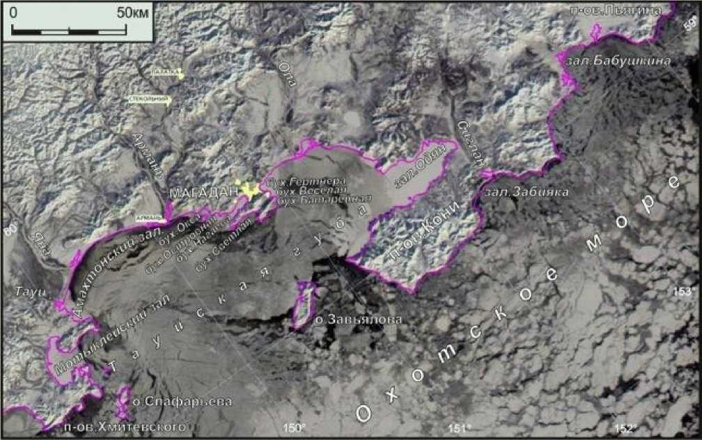
Magadan part of the Northern part of the Sea of Okhotsk — from Hmitievsk peninsula to Piyagin peninsula differs of wide areas, which border from the West and the North-east with greater indentation of the coast line with many bays, harbors, peninsulas and islands (pic.1). Insularity of bays and harbors because of direct influence of long period waves of the high sea specifies display of processes of relief formation and soft sediments of coastal zone1. It also determines some other character of participation in such processes of ice coverage. And moreover the dynamics of both wave processes of relief formation and soft sediments and with participation of ice coverage are applied periodical changes of sea level because of tidal power. Here prevail incorrect lunisolar semidiurnal tides (in Tauiskaya bay) and lunisolar diurnal tides (near the Koni peninsular) with maximum amplitude of 5 meters and more [2]. Specifics of morpholithogenesis in the coastal zone of tidal Arctic waters is very weakly reflected in fundamental works dedicated to relief of sea coasts [1, 3, 4].
Pic. 1. Typical for midwinter icy scenery in the Northern part of the Sea of Okhotsk (picture was made in January, 31, 2007). We can see: slough ice which drifts to the west in the high sea; pried from the coast huge ice floes in Tauysk bay; stationary shore ice belt in Motykleysk, Odyan, bays, in Gartner, Nagayev, Ok-sa harbors and in the western part of Amachtonsk bay near the river Tauy
As showed longstanding field and distance researches with use of aerial imageries and sa- tellite images 1 meter-resolved from internet services Google Earth and SASPlanet, formation of relief and soft sediments (morpholithogenesis) in the coastal zone of Magadan is done under the influence of abrasion swash sea activity; coastal slopping processes with use of cryogenesis, provoked by abrasion; ice hummocking and ice transposition of fragmentary material; diastrophic movement; seismic intensity, tsunami, etc. In this article because of volume limits we overview mostly processes of morpholithogenesis with participation of flexible ice cover, caused as a result of activity of tidal forces. Other publications are dedicated to other variants: ready [5-9] and soon- to-be.
Dynamics of ice cover
Harbors of Magadan — Nagaev, Gartner, Veselaya, Batareynaya, Svetlaya, Ostrovnaya, Ok-sa and others — up to six-seven months a year (from November-December to April-May) are covered with fast ice, which reach to the end of winter the thickness 1—1,5 meters (pic.1). By that, in water areas of Tauysk bay and the whole sea of Okhotsk the ice situation is more dynamic. Here prevails the drift of great (in tens and hundreds of kilometers) ice floes, which are changed during severe winters for some period of time (one, two months) by their stoppage, congealing and ad- freezing to coasts [2]. Under the actions of storms, especially at the beginning and at the end of winter, drift starts again. Destruction of fast ice in bays happens usually not because of melting in the field, as for example in enclosed water bodies, but because of separation from coast and shifting to the high sea. It usually happens — when there are no extreme wind or others influences — in the first, second or sometimes in the third decades of May, when ice depth becomes less than 1 meter, and tidal cracks stop regulating even at night.
Wind-tidal forces essentially are more effective on fast ice — up to its often destruction and shifting — in more open bays: Gartner, Batareynaya, Ostrovnaya, than in practically bottleshaped, for example, Nagayev bay. By that wind waves in the Nagayev bay have smaller period, than in the Gartner bay. The role of filter, which doesn’t pass long period waves, plays tight entrance to the Nagayev bay. Along the shore ice edge of all the bays — in contact with its drifting ice — appears wind-waves cracks, leads and hummock zones.
In the shallow Gartner bay in littoral with width up to 1,5 km, the fast ice is crashed with the system of tidal cracks, which play the role of joints for tidal fluctuations in sea level during lunar cycle with amplitude of maximum up to 5 meters. They are sometimes renewed and again healed by young vertical-striped ice (pic.2). Number of cracks at the littoral grow — with growth of fast ice and its hardness — up to 10 things and more. In the Nagayev bay this process is less expressed because of deeper waters and smaller width of littoral; also because of impaction of fast ice by landing places, 300 meter rock breakwater and sunken weasels at the enter to the bay.
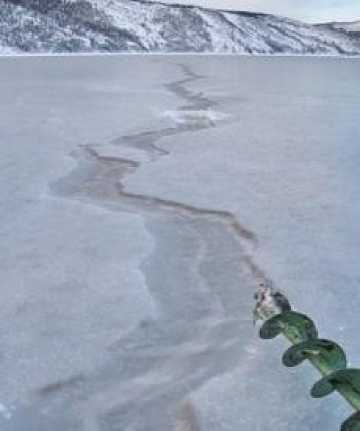
Pic. 2. Tidal articulated crack in the Nagayev bay (February, 17, 2008), which is healed by vertical-striped ice in between high-amplitude vertical ice shoves
Ice hummocking
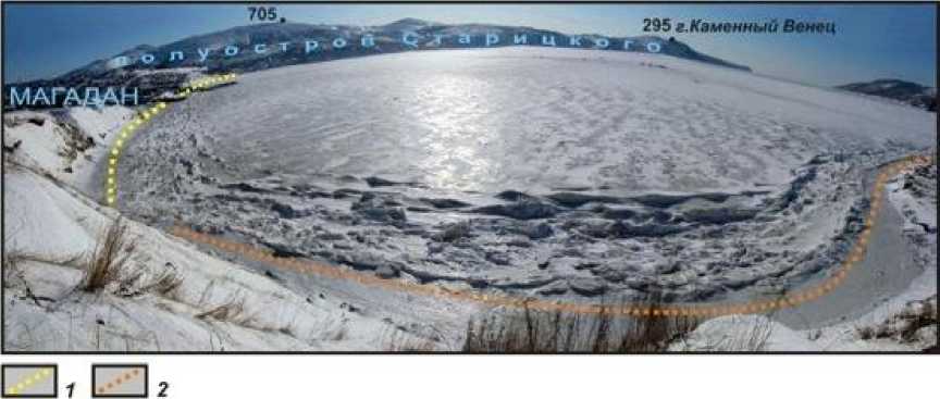
In winter at the water level appears ice terrace with ice depth of coming to maximum amplitude of tidal oscillations (pic 3, 4). It differs from the other part of fast ice (which is afloat and has the depth up to 1-1,5 meter) in the way, that it freezes to a coast and is absolutely immovable, in comparison with joining dynamic part of fast ice, which always shifts verti cally because of tidal oscillations and horizontally because of ice hummocking; it is separated from it by the system of cracks, which is regularly renewed and again frizzed.
Pic. 3 Coastal torosses and coastal ice terrace in the Nagayev bay: 1 — low with slope in the eastern coast; 2 — higher in bold northern coast (March, 4, 2010)
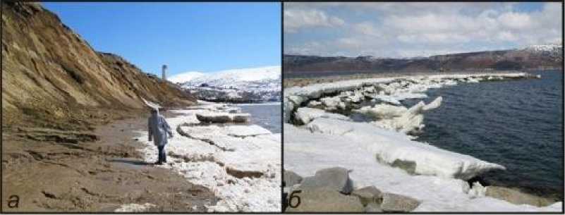
Depth of coastal ice terrace is higher in bold coasts, as for example, at the slope of break- water in the Nagayev bay (pic. 4 б), lower — in shelfy ones, as at the beach of its eastern coast
(pic. 3, 4 а). Coastal terrace protects the beach from hummocking of dynamic ice cover, caused as a result of activity of tidal forces (pic. 3, 5 в) and takes to its surface all the slop fragmentary ma- terial from the coast, as it is seen at pic. 4 а.
Pic. 4. Crumbled coastal ice terrace in spring: а — in the slope of the eastern coast (May, 11, 2008); б — at the slope of breakwater by the southern coast of the same bay (May, 13, 2007)
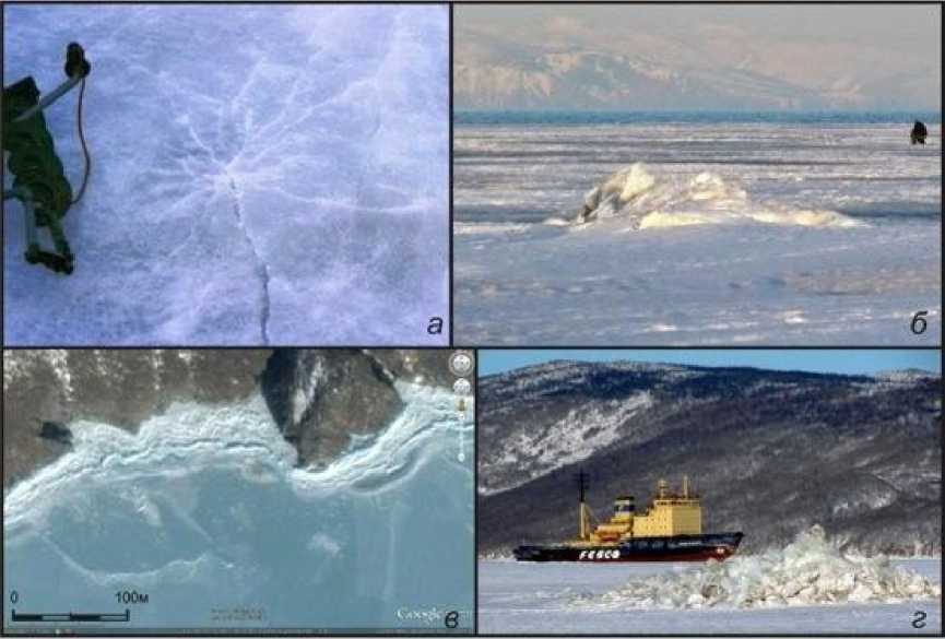
Pic. 5. One of various star cracks ( а ), which appear at the surface of fast ice in the littoral zone by its «fix-ing» during low tides to the exposed stones (December, 21, 2003); «star» hummock ( б ), which appeared from star crack form big stone by the end of winter’s deep ice(April, 25, 2009); multiple star hummocks (small points), coastal hummocks and coastal ice terrace by enter to the Odyan bay at the beginning of winter ( в ); great star hummock ( г ), which appears at the exploded in 1947 and sunken in the Nagayev bay the ship «Viborg»
Ice hummocking mostly influence coast of open water areas, especially in mulls than in closed from the window bays. Result of hummocking by dynamic ice floes is well expressed in the high level of mammocks’ rounding at the front bench of paleoseismological tearing away of Vos-tochny-0,3 (mull Vostochny, pic. 6).
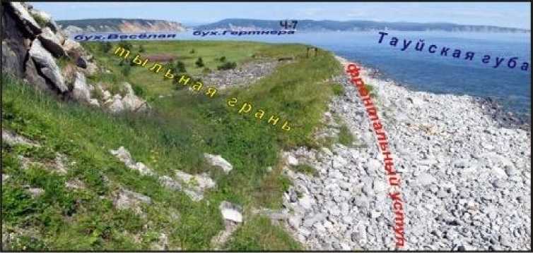
Pic. 6. Rounded as a result of tidal activity and ice hummocking pigs at the front bench of paleoseismologi-cal tearing away of Vostochny-0,3 (aging more than 2 thousand years [9]), which is composed by sharp- cornered benches and pit gravel. Ch-7 — paleoseismological tearing away Cherniy-7 at the northern coast of the Gertner bay
In spring during destruction of ice terrace appear mostly isometric formed «micro ice-bergs» with the high at the Magadan plot up to 5 meters. In many cases in May and June in the already cleaned from ice Magadan bays winds and streams take «alien» slough ice, which source is the north of the Sea of Okhotsk (pic. 7). There in Gizhinsk and Penzhinsk bays oscillatory tidal amplitude attains maximum value for the Pacific Ocean — 9,6-12,9 meters. Correspondingly to it the hight of Penzhinsk micro icebergs could be more than 12 meters.
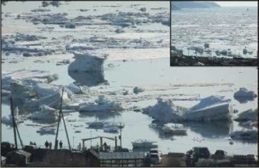
Pic. 7. Very huge «micro icebergs» at the shoal of Nagayev bay — fragments of destroyed coastal ice terrace in spring, which was brought from the sea of Okhotsk (May, 12, 2013)
Ice «press»
By low tides the fast ice at the littoral lies down the hidden pitfalls and at their surface appear multipath stelar cracks, which according to the growth of ice depth (up to 1,3-1,5 meters) and its heaviness open, increase broadwise and lengthwise and change into rather well-defined in the relief of ice surface stelar torosses (pic. 5).
The strength of influence of the fast ice on the bed could demonstrate the example of fast (for three years) dip of sunken in 2006 and turn turtle large refrigerator trawler2 «Professor Moi-seev» (pic. 8) in bottom mud under its pressure of fast ice. Now back of a ship is unseen even by the lowest tides, but earlier it rose above for more than 2 meters. In the same way, apparently, sink in the soft sediments of the littoral also chunks and gibbers.
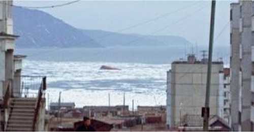
Pic. 8. Sunk in the Nagayev bay LRT (large refrigerator trawler) «Professor Moiseev» (May, 18, 2006)
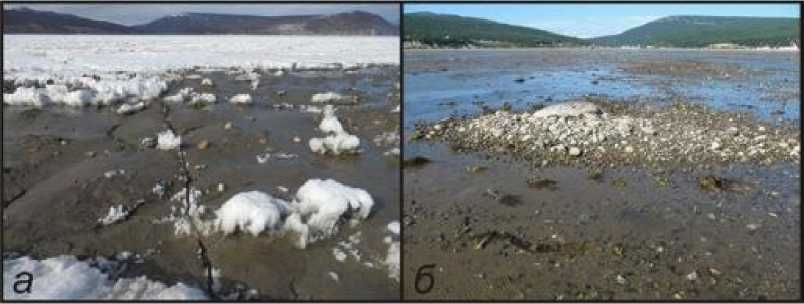
When the fast ice bottoms at the littoral during low tides, sand and pebbles freeze to its sole. With the growth of ice depth such sandpebble lenticular interbeds appear to be at the surface by the end of winter. As a result of spring dissolution of ice at the top, by May they crop out the fast ice by its depth of about 1 meter. Because of sun warm-up of darker than the ice sand-pebbles interbeds basins of ice water appear with the depth of about 0,5 meters and size over 10 meters (pic. 9 а). At that they begin to melt then, when inter beds are still under the ice in the first decimeters.
Ice and other transpositions of fragmentary material
Process of ice transposition of fragmentary material is represented in the following way. Ingoing from abrupt coasts to ice fragmentary material comes to fast ice (pic. 4 а), after which destruction in spring zooms off from the beach scarp by ice and as far as it melts it sinks out. But in tid- al Arctic seas other two and probably more effective mechanisms of ice transposition function.
Pic. 9. Ice transposition of fragmentary material as a result of its freezing to the lower surface of fast ice, which bottoms in the littoral zone of the Gartner bay by low tidal levels: а — exit of sand and small pebbles at the surface of fast ice because of spring melting at the top (May, 10, 2013); б — put to the littoral pebbles and boulder stones, which are discordant with typical for native scenery much smaller cave deposits of particle composition
Freezed at the bottom and cropping up in spring (pic. 9 а ) fragmentary material after destruction of fast ice and coastal ice terrace zoomed off in blocks of ice over different distances, including southern parts of the sea of Okhotsk, where ice finally melts and dumps all the fragmentary materials at the bottom (pic. 9 б ).
During the period of spring destruction of ice terrace its fragments, because of tidal oscillations, shake — alike crampons — and remove from the encroachment line freezed in ice huge (up to 1 meter and more) stones and spread them over foreshore mostly over short distances — meters and hundreds of meters, which are limited by huge weight of fragments (pic. 4 б ). Topographic location of huge observable mammocks at the encroachment lines under such an ice influence changes over years of inspection.
Especially observable the result of alongshore ice transposition is in the Magadan bay Oksa (pic. 10), where the number and size of mammocks on the beach is gradually decreasing from bases of rocks (with great huge rockslides) at the western and eastern shores to the top of the bay.
As the result of drifting of «micro icebergs» (pic. 7) from the north of the sea of Okhotsk its overrun through the whole sea of fragments of rocks, unusual for the region, is possible, for example, of Pre-Cambrian crystalline schists, aposandstones, limestones, pea pebbles, hidden in the basin of the sea of Okhotsk just at the Thaigonos peninsula. Their discovery somewhere in the south of the sea of Okhotsk could put at a stand researchers of lithology and marine deposits petrography.
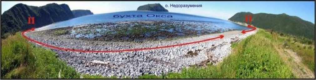
Pic. 10. Directions (shown with pointers) of decrease of number and largeness of mammocks at the bench from bases of rocks to the top of the Oksa bay because of ice transposition
Biogenic transposition of fragmentary material is provided on a small scale by means of affixion of weeds, Laminaria (sea girdle) to small stones at the bottom in the littoral zone. With swift tidal waters stones with Laminaria are drown on bottom mostly in direction of retreating sea (pic. 11 а ).
An important role in moving of fine-grained soft sediments at the littoral play king worms (Nereis virens). Built by them multiple uliginous-sand pits under the entrances to their squats (pic. 11 б ) are regularly washed away by the sea, by moving thorough littoral — because of tides — surf zone, and material, which they were built of is washed away to the lower hysographic level of sea bottom.
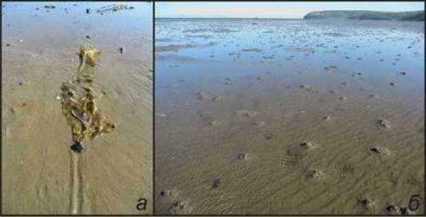
Pic. 11. Drill at the sand bottom in the littoral zone of the Gartner bay, which appeared as a result of transposition by tidal stream of pebble with affixion of Laminaria ( а ). «Hollows», created by king worms - Nereis vireos — over their squats ( б )
Influence of processes of morpholithogenesis on the ecosystem
Influence of morpholithogenesis processes in the coastal zone of tidal Arctic seas on bio-genous constituent of ecosystem is expressed ambiguously and differently directed. In such a way, ice transposition of huge blocks and boulders at the littoral forms more difficult relief of seashores, which is advantageous for bracing of weeds, mollusks rather than at the flat sand-pebble beach, subjected to intensive wave-cut processing. Sea calfs and sea birds like to relax on huge blocks, which drain low water. Less intensive, but over greater distances of bottom its relief’s complicity is shown by ice transposition of sand, pebble and small blocks, which freeze to the lower part of fast ice.
At the same time, «ice press» produces back-to-back work, smotthing the relief of bottom in the drying zone. Regular ice «ploughing» of soft sediments of coastal zone by means of tidal fluctuations in sea level gives food to such fish as navaga (Eleginus) and eelpout (Zoarces vivparus) which mostly eat benthos at the littoral. In March under cracks between coastal ice terrace and movable fast ice on the stony fields in the phase of high tides lays eggs codfish [10]. Herring deposits eggs in the end of May — beginning of June mostly in vegetation of Laminaria, which grow at irregular places of littoral, formed also by means of coastal ice transposition of huge blocks and boulders. In such vegetations sea-urchin lives the whole summer, which at the beginning of summer eats herring’s caviar. Wolffish (Anarhichas) also hides in summer in the same places, but eats mollusks and crabs. Great flounder (Platichthys stellatus) in the same period of time comes near to the coast, attracted by caviar of herring and capelin. The biggest eat capelin itself. Big flocks of smelt (Osmerus eperlanus L.), which live under hummocks within the littoral on the depth of 5— 25 meters for the practically whole winter, at the end of winter — usually at the beginning of May — enter the drying zone together with navaga under the remained as a result of degradation of ice coverage sheet of ice with width of 1-2 kilometers. Crabs and finger-fishes (Asteroidea), avoiding the influence of «ice press», come to the coast just in deep parts of sea. Sea calfs with increase of ice depth migrate to the shore ice edge and to floating ice sheets, in spite of high concentration of candle fish and navaga in winter just under the coastal ice ledge. They come back to bays just after destruction of ice following flocks of spawning herring — independent whether drift ice is there or not.
Feedback effect of biogenous constituent of the eco-system on morpholithodynamic happens. It is expressed in noted processes of transposition of small stones with affixion of Laminaria to the lower hysographic level because of ebbstreams; as well as because of washaway and drif-
Арктика и Север. 2014. № 17 tage to the higher depth of hollows under the squats of clam worms, during their washaway surf zone, migrated under the influence of sea level tidal oscillation.
Conclusion
Specifics of morpholithogenesis in the coastal zone of the Northern part of the sea of Okhotsk is in common characteristic for all Arctic tidal seas. It is peculiar for it formation of coastal ice terrace, which limits influence of sea waves on the coast during only the summer period (for about half a year). Flattering of marine deposits at the littoral furthers pressure of fast ice with appearing on it of stellular cracks and torosses. With freezing of fragmentary material at the bottom of fast ice is provided mass scale spread of sediments through the whole sea of Okhotsk. More localized spread takes place mostly in the coastal zone because of freezing of huge blocks in the coastal ice terrace and its future destruction. An important role in morpholithogenesis at the littoral of northern seas plays, as it appeared to be, biogenies spread of precipitates. Influence of processes of morpholithogenesis in the coastal zone of Arctic tidal seas on the biogenies constituent of the ecosystem and feedback effect of biogenies constituent of the ecosystem on morpholi-thodynamic plays an important role.
References Specific character of relief and loose sediments forming in the coastal zone of tidal icy seas (in the context of the northern part of the Sea of Okhotsk) ecosystem
- Kaplin P.A., Leontyev O.K., Lukyanova S.A., Nikiforov L.G. Berega [Coasts]. Moscow, Mysl publ., 1991, 479 p.
- Atlas Sakhalinskoy oblasty [Atlas of the Sakhalin Region]. Moscow, GUGK, 1967, 135 p.
- Leontyev O.K. Osnovy geomorfologii morskih beregov [Fundamentals of sea coasts geomorphology]. Moscow, MGU publ., 1961, 419 p.
- Shchukin I.S. Obshchaya geomorfologiya. T. III [Common geomorphology. Vol. III]. Moscow, MGU publ., 1974, 382 p.
- Vazhenin B.P. Morfodinamika beregov buhty Nagayeva (Okhotskoye more) [Morphodynamics of the coasts of the Nagayev bay (the sea of Okhotsk)]. Geomorfologiya [Geomorphology]. 2012, no.4, pp. 45—53 (in Russian).
- Vazhenin B.P. Problemy issledovaniya tsunami v Severnom Ohotomorye. Problemy kompleksnogo geofizicheskogo monitoringa Dal’nego Vostoka Rossii [Problems of researches of tsunami in the northern part of the sea of Okhotsk. Problems of complex geophysical monitoring of the Russian Far East]. Trudi vtoroy regional’noy nauchno-prakticheskoy konferencii 11-17 oktyabrya 2009 g. [Proc. 2nd regional science-practical conference, October, 11-17, 2009]. Petropavlovsk-Kamchatsky, 2010, pp. 312—317 (in Russian).
- Vazhenin B.P. Rol’ zunami v formirovanii relyefa morskih poberezhiy Dal’nego Vostoka Rossii. Geomorhologicheskiye processy i ih prikladniye aspekty [Role of tsunami in formation of Russian Far East sea coasts relief. Geomorphological processes and its applied aspects]. VI Shchukinskiye chteniya. Trudy (kollektiv avtorov) [VIth Shcukin scientific conference. Proc. (joint authors)]. Moscow, Geofraphic faculty of MGU, 2010, pp. 281—283 (in Russian).
- Vazhenin B.P. Prirodniye opasnosti na territorii g. Magadan [Natural perils on the territory of Magadan]. Materialy Mezhdunarodnoy konferencii «Gorod i geologicheskiye opasnosti» 17-21 aprelya 2006 [Proc. of the International conference «City and geological perils», April, 17-21, 2006]. SBR, VNIIG named after B.E.Vendeev, 2006, pp. 33-40 (in Russian).
- Vazhenin B.P., Lebedincev A.I. Morskiye beregoviye obvaly i ih znacheniye v drevnem osvoyenii Severnogo Priohotya. Neolit i paleolit Severa Dal’nego Vostoka [Sea coastal landslides and its value in the ancient exploitation of the Northern part of the sea of Okhotsk. Neolithic and Paleolithic of the North of the Far East]. Magadan, SVKNII DVO RAN, 2006, pp. 164-175.
- Malinin V. Sportivnoye rybolovstvo v Magadanskoy oblasti [Sport fishing in the Magadan region]. Magadan, book publ., 1967, 120 p.
