Study on the planning of rural land spatial utilization by improved particle swarm optimization

Author: Yi Wenzhou
Journal: Компьютерная оптика @computer-optics
Section: Численные методы и анализ данных
Article in issue: 6 т.44, 2020.
Free access
The planning of rural land space utilization is a very important problem. In this paper, the objective function of rural land use planning was analyzed firstly, and then the improved particle swarm optimization (IPSO) algorithm was obtained by improving the inertia weight for solution. The results showed that the land space use in the study area was more reasonable after the planning based on the IPSO algorithm, the forest land and construction land increased, the area of grassland, cultivated land and water area reduced appropriately, the aggregation degree of all types of land improved, and the space distribution was more planned, which was more conducive to production activities. The analysis results verify the effectiveness of the IPSO method in land space use planning, which can improve the efficiency and benefit of land space use, and it can be popularized in practical application.
Particle swarm optimization, land spatial utilization, land planning, rural
Short address: https://sciup.org/140250076
IDR: 140250076 | DOI: 10.18287/2412-6179-CO-723
Text of the scientific article Study on the planning of rural land spatial utilization by improved particle swarm optimization
As an important part of economic development, the rational use of land resources can promote the further development of the economy, on the contrary, it will hinder the economic development and even cause irreversible negative impact on the environment [1]. In the process of urbanization, the rural land space use has been greatly affected. A large number of rural land has been transformed into urban land, and the types of land space use are becoming more and more diversified. However, there are also problems such as low land use rate, serious pollution, soil erosion [2], etc. The refore reasonable utilization planning methods are needed. Ai et al. [3] studied the land planning of the fast-growing coastal areas, designed a land space use planning method based on ant colony algorithm, analyzed the planning scheme by taking Dou-men District as the research area, and found that the most reasonable scheme was to consider economic development and environmental protection. Gong et al. [4] established three target driven planning schemes according to the situation of the study area and found that Scheme C increased the suitable habitat area of red crowned crane by 24% and the regional economy by 41.3 %, which showed good operability. Mohammadi et al. [5] designed a hybrid algorithm combining with meta heuristic method to solve the problem of land use optimization and found through practice that the method had high quality and efficiency. In order to improve the situation of soil and water loss in the Loess Plateau, Han et al. [6] optimized the land use mode in Luoyugou watershed of the Yellow River Valley. The results showed that the runoff and sediment yield in this area decreased after optimization, which had a significant effect on reducing soil and water loss and increasing vegetation coverage. In this study, the planning problem of rural land space use was solved by using an improved particle swarm optimization (IPSO) algorithm, and a town in Guangzhou was taken as the research area for example analysis. This study aims to make some contributions to improve the efficiency of rural land space use and promote the harmonious development of economy and environment.
Rural land space use planning
The purpose of rural land space use planning is to realize the sustainable use of land through scientific and reasonable arrangement [7], which involves the maximization of economic, ecological and social benefits [8]. It is a multi-objective planning problem, specifically as follows: (1) economic objective: to enable limited land resources to produce more products; (2) ecological objective: to realize the relationship between human and land and between human and nature; (3) social goal: to provide the most efficient service possible.
In the mathematical model, the land to be planned can be expressed as a N×M grid cell, in which there are k types of land space use, and the utilization area of different types is set as Sk. Three objective functions are selected as the planning objectives of land space use: Ф minimizing the conversion cost objective: before and after the planning, the conversion of land space use type needs to invest a certain amount of cost; less investment cost indicated more reasonable planing; @ maximizing the degree of land space aggregation: in the planning of land space use, the land with the same purpose should be clustered as much as possible to reduce land fragmentation, which is more effective to improve comprehensive effect; ® maximizing land suitability: in the planning of land space utilization, the higher the suitability of land for some purpose, the larger its positive influence on econo- my and environment and the more reasonable the planning. In addition, in the land space utilization planning, the planning effect should also meet some constraint conditions, and the constraint conditions set in this study mainly include: Ф the total planning area is the sum of all types of land areas; @ there is only one type of land in a unit, so the final objective function can be expressed as:
NMK fl = ZZZ CfXjk =1 j=1 k=1
NMK f2 = ZZZ BjkXjk =1 j=1 k=1
NMK
f3 = ZZZ A
= 1 j = 1 k = 1
K
Ё Sk = S k=1
K
Z X jk = 1
k = 1
w min
( w max - w min ) X ( f — f min )
w = <
max
^^^^^^B

( W max — W min ) x t
t max
, f > f ag
f avg
where w max and w min are maximum and minimum values of inertia weight, / avg and / min are the average value and minimum value of particle fitness, and t max stands for the maximum times of iterations.
2. Rural land use planning model based on IPSO
Suppose that there are five types of land, which is coded by integer alignment of 0–5. The specific relationships are: 1 – forest land, 2 – grassland, 3 – cultivated land, 4 – construction land, 5 – water area, and 0-non-research object, which can be represented by a twodimensional matrix. Taking Fig. 1 as an example, it is a 4 × 4 grid network, (1, 1)=0 indicates that this unit is not in the planning area, (3, 2)=5 indicates that the unit is water area. Each particle represents a land space use
where C c / is the conversion cost of unit ( i , j ) transforming from purpose c to purpose / , X jk is a binary variable, if the use type of unit ( i , j ) is k , then its value is 1, otherwise its value is 0, B ijk is the number of land whose use type was k in unit ( i , j ), A ijk is the suitability when the use type of unit ( i , j ) is k , and S stands for the total land area.
IPSO algorithm
1. PSO algorithm
PSO algorithm is an algorithm [9] inspired by the foraging behavior of birds, which has been widely used in combinatorial optimization problems [10]. In a D– dimensional space, suppose that the size of particle swarm is N , the position and velocity of the i -th particle are X i = ( X i 1 , X i 2 , " , X id ) and V i = ( V i 1 , V i 2 , " , V id ), the historical best position of individual is P i , the historical best position of swarm is P g , and updating formulas of position and velocity can be expressed as:
vS1 = wv td + C 1 r 1 ( P td - x td ) + c 2 r 2 ( p‘g d - x td ) , (2)
x d = x id + v ^' , (3)
where t stands for times of iterations, w stands for inertia weight, c 1 and c 2 are acceleration constants, in (0, 2), and r 1 and r 2 are random numbers.
IPSO algorithm
The value of inertia weight has a great influence on the convergence performance of the algorithm [11]. In order to obtain better optimization results, the inertia weight of the algorithm is determined by the following equation:
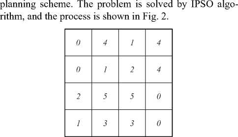
Fig. 1. Distribution of land space use types
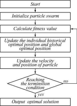
Fig. 2. The solution flow of land space use planning.
Case analysis
3. Research area
The research area was a town in Guangzhou, with a total area of 116.78 square kilometers, and abundant forest vegetation. There were a large number of village and town enterprises, which promotes the economic development, but the demand for construction land in this area becomes more and more vigorous, occupying a large number of cultivated land and causing land pollution and waste, so it is urgent to make a reasonable planning for the local land space utilization. The current situation of land space utilization in the study area from 1996 to 2016 is shown in Table 1 and Fig. 3.
Table 1. Proportion of different land space use types (%)
|
Land type |
Forestland |
Grassland |
Cultivated land |
Construction land |
Water area |
|
1996 |
37.62 |
27.18 |
29.36 |
5.62 |
0.22 |
|
2002 |
36.78 |
26.03 |
29.12 |
7.82 |
0.25 |
|
2006 |
36.14 |
25.49 |
28.12 |
9.37 |
0.88 |
|
2012 |
37.54 |
23.67 |
24.98 |
12.56 |
1.25 |
|
2016 |
37.69 |
22.56 |
18.67 |
20.34 |
0.74 |
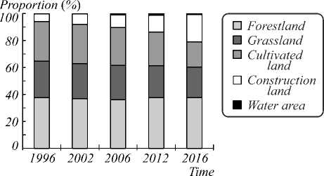
Fig. 3. Changes of land space use types in 1996-2016
It was found from Table 1 and Fig. 3 that the land in the study area mainly consisted of forestland, grassland and cultivated land between 1996 and 2016, with a slight increase in the area of forestland, a decrease in the area of grassland and cultivated land, and a significant increase in the construction land.
The land space use pattern in the study area in 2016 was analyzed using land landscape index [12]: Ф the patch density = the number of type patches/the area of class, and the larger the value, the higher the scatter degree; ® the shape index = the perimeter of the smallest circle of patches/the perimeter of patches, and the larger the value, the more complex the shape; ® the landscape isolation degree = the minimum distance index/the area of class patch, the larger the value, the higher the isolation degree. The analysis results are shown in Table 2.
It was found from Table 2 that the scattered degrees of the construction land and water area were relatively high, i.e., the distribution was scattered, but the shape of patch was relatively regular, while the aggregation degrees of forestland, grassland and cultivated land were relatively high, i.e., the distribution in space was concentrated, and the shape of patch was relatively complex.
Table 2. Analysis results of land landscape index
|
Land type |
Forestland |
Grassland |
Cultivated land |
Construction land |
Water area |
|
Patch density |
0.18 |
0.21 |
0.04 |
1.21 |
1.33 |
|
Shape index |
2.36 |
3.51 |
5.12 |
0.64 |
0.07 |
|
Landscape isolation degree |
0.51 |
0.58 |
0.13 |
4.11 |
8.71 |
4. Parameter setting
The land space use of the study area was planned using the IPSO algorithm. The study area was divided into 11678 grids in a size of 100×100 m, the population parameter of particle swarm was 20, and the acceleration constants followed the general setting way, c 1 = c 2 =2, the number of iterations was 1000, and the inertia weight was adjusted according to equation (4).
-
5. Planning results
The IPSO planning results are shown in Table 3.
Table 3. The planning results of IPSO algorithm
|
Land type |
Forestland |
Grassland |
Cultivated land |
Construction land |
Water area |
|
Number of grids |
4501 |
2622 |
2074 |
2396 |
85 |
|
Proportion / % |
38.54 |
22.45 |
17.76 |
20.52 |
0.73 |
Compared with 2016, the forestland increased by 0.85 %, the grassland decreased by 0.11 %, the cultivated land decreased by 0.91 %, the construction land increased by 0.18 %, and the water area decreased by 0.01 %. The planning results were analyzed using land landscape index, as shown in Fig. 4.
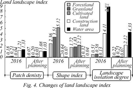
It was found from Fig. 4 that the indexes decreased and the patch density of different types of land decreased after planning by the IPSO algorithm, indicating that the distribution of different types of land use was more centralized, and the shape index also decreased, indicating that shapes of different types of lands were more regular, the landscape isolation degree significantly reduced, indicating that the layout of land space use was more compact, the land use was more reasonable, and it satisfied the intensification requirement on the study area better.
Discussion
The planning of rural land space use has very important practical value for exerting the potential of land use, realizing the balance of land ecosystem [13] and promoting the harmony between human and land. With the development of city and countryside integration [14], it is more and more important to solve the problem of rural land use. At present, there are many problems in the rural land use: (1) the construction of rural infrastructure is not perfect and the layout is scattered; (2) the construction land is idle and the utilization degree is low; (3) the farmers engaged in farming reduce and the cultivated land is wasted; (4) the land structure is unreasonable, the land quality is poor, and the exploitability is low. In order to solve the problem of rural land space utilization, it is necessary to plan it through scientific methods.
In this study, the objective function of land space use planning was analyzed, and then it was solved by the IPSO algorithm. It was found from the research results of the study area that the land space use situation of the study area was more reasonable after planning by the IPSO algorithm. Firstly, the area of forestland increased, the area of grassland slightly reduced, but the sum of the them was still higher than that before the planning, and the distribution was more compact, showing that the planning protected the green land in the study area and improved the local ecological benefits. From the perspective of cultivated land, the area of cultivated land decreased by 0.91 % after planning. With the development of society and economy, the number of farmers engaged in farming in the countryside decreased gradually; therefore the appropriate reduction of cultivated land was reasonable. It was seen from the comparison with 1996– 2016 that the reduction of 0.91 % of cultivated land was far less than the reduction of cultivated land in the past 20 years, and moreover the concentration degree of the cultivated land improved, which was more conducive to the development of agricultural activities. From the perspective of construction land, the area of construction land after planning increased by 0.18 %, which was to meet the demand of industrial development in the research area for construction land; more over the distribution of construction land was more compact and tends to concentrate, which was helpful to meet the demand of production activities. Finally, from the perspective of water area, the water area only reduced by 0.01 %, which showed that the planning achieved the protection of water environment and the harmony between land use and ecological environment.
Although some achievements have been made in the study of land space use planning in this paper, there are still many shortcomings. For example, only five types of land were considered, the objective functions chosen were few, and whether PSO algorithm can be further improved still needs further study.
Conclusion
Taking a town in Guangzhou as an example, this study set the objective function of rural land space use planning and solved it with the IPSO algorithm to obtain the best planning results. The results showed that the areas of forestland and construction land in the study area slightly increased, while the area of other types of land decreased. From the perspective of land landscape index, the distribution of different types of land was more compact, and the aggregation of land space use significantly improved, which verified the effectiveness of the IPSO algorithm for land space use planning. The IPSO algorithm can be promoted and applied in practice.
References Study on the planning of rural land spatial utilization by improved particle swarm optimization
- Xu KP, Wang JJ, Chi YY, Liu M, Lu HJ. Spatial optimization and sustainable use of land based on an integrated ecological risk in the Yun-Gui plateau region. Acta Ecologica Sinica 2016; 36(3): 821-827.
- Zhang W, Huang B. Soil erosion evaluation in a rapidly urbanizing city (Shenzhen, China) and implementation of spatial land-use optimization. Environ Sci Pollut Res 2015; 22(6): 4475-4490.
- Ai B, Ma S, Wang S. Land-use zoning in fast developing coastal area with ACO model for scenario decision-making. Geo Spat Inf Sci 2015; 18(1): 43-55.
- Gong X, Cao MC, Wang D, Le Z, Sun X, Xu H. Spatial optimization simulation of land use pattern in Yellow River Delta Nature Reserve. Transactions of the Chinese Society of Agricultural Engineering 2017; 33: 355-361.
- Mohammadi M, Nastaran M, Sahebgharani A. Development, application, and comparison of hybrid meta-heuristics for urban land-use allocation optimization: Tabu search, genetic, GRASP, and simulated annealing algorithms. Comput Environ Urban Syst 2016; 60: 23-36.
- Han YN, Niu JZ, Xin ZB, Zhang W, Zhang TL, Wang XL, Zhang YS. Optimization of land use pattern reduces surface runoff and sediment loss in a hilly-gully watershed at the Loess Plateau, China. Forest Syst 2016; 25(1): e054.
- Zhang H, Zeng Y, Jin X, Shu B, Zhou Y, Yang X. Simulating multi-objective land use optimization allocation using Multi-agent system-A case study in Changsha, China. Ecol Modell 2016; 320: 334-347.
- Zhu D, Xiong P, Fang S. Optimization of land use in Zhangjiajie City under tourism ecological security constraints. Acta Ecologica Sinica 2018; 38(16): 5904-5913.
- Taherkhani M, Safabakhsh R. A novel stability-based adaptive inertia weight for particle swarm optimization. Appl Soft Comput 2016; 38: 281-295.
- Hu T, Hu M, Lv L, Zhou C. Improved genetic algorithm-particle swarm optimization based on multiple populations for 3d protein structure prediction. J Comput Theor Nanosci 2015; 12(7): 1414-1419(6).
- Liu J, Mei Y, Li X. An analysis of the inertia weight parameter for binary particle swarm optimization. IEEE Trans Evol Comput 2016; 20(5): 666-681.
- Chen F, Chen J, Wu H, Hou DY, Zhang WW, Zhang J, Zhou XG, Chen LJ. A landscape shape index-based sampling approach for land cover accuracy assessment. Sci China Earth Sci 2016; 59(12): 2263-2274.
- Yue Y, Ye X, Zou X, Wang J, Gao L. Research on land use optimization for reducing wind erosion in sandy desertified area: a case study of Yuyang County in Mu Us Desert, China. Stoch Environ Res Risk Assess 2016: 1-17.
- Xu Q, Yang K, Wang G, Yang Y. Agent-based modeling and simulations of land-use and land-cover change according to ant colony optimization: a case study of the Erhai Lake Basin, China. Nat Hazards 2015; 75(1): 95-118.
