Substantiation for including municipalities of the Magadan oblast in the arctic zone of the Russian Federation

Author: Galtseva Natalya V., Favstritskaya Oksana S., Sharypova Olga A.
Journal: Economic and Social Changes: Facts, Trends, Forecast @volnc-esc-en
Section: Regional economy
Article in issue: 1 т.15, 2022.
Free access
The relevance and significance of the study are determined by the following: the analysis of international and Russian practices of establishing borders of the Arctic zone, trends and their changes observed in recent years in Russia, the study of the characteristics of economic activity in the Arctic, the adoption of the federal law to support business activities in the Arctic zone of the Russian Federation. The purpose of the work is to substantiate the inclusion of a number of such municipalities of the Magadan Oblast as Severo-Evensky, Omsukchansky, Srednekansky and Susumansky urban districts in the Arctic zone of the Russian Federation. The reason is the similarity of their natural, climatic and geographical characteristics with the Arctic regions, identity of the socio-economic development problems, unity of the Magadan Oblast municipalities and the Arctic regions of the Far Eastern Federal District by a common infrastructure. Scientific novelty of the study lies in proving the homogeneity of the conditions of the Magadan Oblast districts and the Arctic regions using the selected criteria. On the example of the project on the development of the Omolon iron-ore cluster, we assessed the effectiveness of its implementation for investors, considering the measures of state support in the Arctic zone of the Russian Federation. Thus, resource savings for the investor, taking into account the Arctic benefits, are more than twice as much as the savings from the use of the preferential economic zone regime in the Magadan Oblast. The research findings formed the basis of the expert conclusion on the expediency of inclusion of a part of the territory of Magadan Oblast into the Arctic zone of the Russian Federation, which will help create favorable conditions for investors in the development of natural resource potential, as well as ensure socio-economic development of the entire region.
Arctic regions, arctic, arctic zone of the russian federation, magadan oblast, borders of the arctic zone, arctic benefits
Short address: https://sciup.org/147237083
IDR: 147237083 | UDC: 332.122:911.6(571.65)
Text of the scientific article Substantiation for including municipalities of the Magadan oblast in the arctic zone of the Russian Federation
The development of the Arctic territories has been in the focus of attention of specialists in various fields for many years. Active discussions are going on around the issue concerning the search for a unified approach to classifying land territories as part of the Arctic zone. The fundamental factors that distinguish an area as pertaining to the Arctic include its location beyond the border of the Arctic Circle and access to the Arctic Ocean. Each state that geographically belongs to the Arctic has its own specific features, according to which, in exceptional cases, the borders of their Arctic land territories have been expanded in order to increase the scale of state support for development of the Arctic zone.
The land borders of the Arctic zone of the Russian Federation (AZRF) have changed several times. The Decree of the RF President “On the land territories of the Arctic zone of the Russian
Federation” 1 was amended three times, expanding the borders of the Russian Arctic. The latest changes are recorded in the Federal Law “On state support for investment activities in the Arctic zone of the Russian Federation” 2 . Even at the stage of its development, the draft law prompted some RF regions to substantiate the inclusion of new territories (municipalities) in the Russian Arctic. Such activity is due to a large-scale list of tax and customs benefits and preferential regulation of labor relations provided for residents of the Russian Arctic (Khodachek, 2021).
The Magadan Oblast, a subarctic region, the northern part of which borders on the Arctic uluses of the Republic of Sakha (Yakutia) and Chukotka Autonomous Okrug, is working to substantiate the inclusion of part of its territory in the Russian Arctic. This is explained by the fact that the climatic, geographical and other conditions of the four municipal formations within the Magadan Oblast (Severo-Evensky, Omsukchansky, Srednekansky and Susumansky urban okrugs) are similar to those in the Russian Arctic.
In the present paper, we do not intend to study in detail all the efforts undertaken by government agencies and research organizations to determine the composition of the Russian Arctic and to develop criteria for its allocation. These issues have already been covered in the works of leading Russian scientists (Zhukov et al., 2018; Lukin, 2019; Pilyasov et al., 2018).
Since the Arctic border can be used for different purposes, there are no officially approved criteria and their values. We are primarily interested in the
Arctic as an object of state administration, a set of subjects (territories) and their socio-economic development. The main objectives of the work are to generalize the currently used and proposed scientific criteria for the allocation of the Arctic land zone and, on the basis of empirical natural and economic material, to prove the compliance of four municipalities of the Magadan Oblast with these criteria in order to include them in the Russian Arctic so that they could get new development opportunities.
The information base included laws and regulations of the Russian Federation, Federal State Statistics Service data, materials of the Ministry of Natural Resources and Ecology of the Magadan Oblast, materials of the Magadan branch of the Territorial Fund of Geological Information for the Far Eastern Federal District, and publications of domestic and foreign scientists.
Review of approaches and criteria for the allocation of the boundaries of the Arctic land zone
World practice has no uniform official criteria for determining the land borders of the Arctic zone. Until the mid-1660s, the borders were allocated quite conditionally. The North was presented as the Arctic plus the sub-Arctic. Foreign authors most often considered the territory of the North and the Arctic through a list of administrative-territorial formations (Zhukov et al., 2018).
For example, economic geographer Louis-Edmond Hamelin determined the nordicity of Canada’s regions based on a comprehensive assessment of ten physical-geographical and economic-geographical features (Soldatkin et al., 2002): geographical latitude of the area, summer and winter temperatures, duration of seasonal soil freezing, precipitation, forest cover, transport accessibility, population density, economic development. British scientists T. Armstrong, G. Rogers, and G. Rowley (Armstrong et al., 1978) also proceed from the set of natural and economic-geographical factors in determining the North and the Arctic. According to American scientists G. Osherenko and O. Young, Arctic territories include those located north of 60°N, but in some cases – much further south (Osherenko et al., 1989).
The Encyclopedia of the Arctic (editor – Professor of Social Anthropology Mark Nuttall) provides the following mandatory criteria for determining the Arctic: high latitude, long winter, short and cool summer, little precipitation, permafrost, frozen lakes and sea in winter, absence of trees (Nuttall, 2005). The Encyclopaedia Britannica states that Arctic conditions are also found far south of the Arctic Circle, and the division into sub-Arctic and Arctic regions shows the distribution of permafrost, glaciers and other indicators (Ingold et al., 2019).
The Arctic Council 3 considers that the border of the Arctic is a line proposed by the developers of the Conservation of Arctic Flora and Fauna (CAFF) project on the basis of a set of natural characteristics . There are no severe restrictions on national approaches in this matter.
“None of the ways of defining the Arctic is satisfactory for all purposes ...” (Nuttall, 2005). The frontiers of the Arctic are being shifted so that certain territories could obtain state support. Thus, Canada, when determining the borders of the Arctic, is guided by the border of 60°N. The USA, taking into account political and economic factors, considers that the Arctic zone includes territories north of the Arctic Circle and south of it. The entire state of Alaska is part of the Arctic, although its southern point is located at almost 53°N. In Norway, there is no definition of Arctic territories in national regulatory legal acts; the Arctic territory is allocated only when conducting offshore operations related to oil and gas production: areas of the Norwegian Sea north of 65°N. In Denmark, the island of Greenland, recognized as part of the Arctic, extends southward to almost 58°N.
In Russia in Soviet times, the North was represented by the regions of the Far North (localities equated to it) and the Arctic regions, which, in turn, were determined by a secret list (Pilyasov et al., 2018). As environmental conditions were changing and new technologies emerging, the Arctic economy at the present stage has increased the number of functions 4 due to the addition of the mineral resources and transport functions (the Northern Sea Route (NSR)). Taking into account the fulfillment of these new functions in the future, the discussion about the borders of the Arctic is taking place both at the international, national and regional levels.
The legislative basis for the state regulation of the development of the Russian Arctic is currently represented by Presidential Decree 164 “On the fundamentals of the state policy of the Russian Federation in the Arctic for the period up to 2035”, dated March 5, 2020; Presidential Decree 645 “On the strategy for development of the Arctic zone of the Russian Federation and ensuring national security for the period up to 2035”, dated October 26, 2020; RF Government Resolution 484 “On approval of the state program of the Russian Federation “Socio-economic development of the Arctic zone of the Russian Federation”, dated March 30, 2021. The territory of the Arctic zone is defined by Presidential Decree 296 “On the land territories of the Arctic zone of the Russian Federation” 5 (hereinafter – Presidential Decree 296) and the Federal Law “On state support for entrepreneurial activity in the Arctic zone of the Russian Federation” 6 (Fig. 1) .
Figure 1. Borders of the Arctic zone of the Russian Federation, 2021
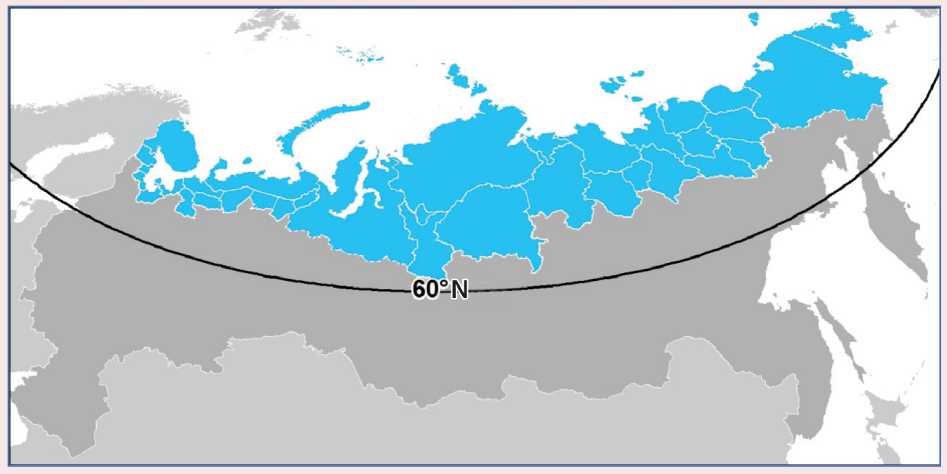
Note: the territory of the Arctic zone of the Russian Federation is highlighted in blue.
Source: Compiled on the basis of Esri CIS spatial data.
Discussions about the uncertainty of the “arctic” criteria of the territories and borders of the Arctic arise regularly both in the scientific community and in public administration (Zhukov et al., 2018; Pilyasov et al., 2018; Kochemasova et al., 2019; Emel’yanova, 2019). Russian scientists offer many scientific approaches to the identification of the southern land borders of the Russian Arctic (Lukin, 2014; Toskunina et al., 2013). Let us note, for example, astronomical (according to the latitude of the Arctic Circle 6633’N) and other options (60th, 65th, 70th parallel of the Northern Hemisphere); bioclimatic (according to the level of discomfort of natural living conditions, according to the July isotherm +10°C); physical and geographical (according to the geographical differentiation of territories and landscapes); administrative (according to territorial and administrative boundaries) (Lukin, 2019); geo-cultural (according to settlement, land use, development of ethnoculture) (Lukin,
2019); geopolitical (according to the availability of access to the seashore of the Arctic Ocean); geo-economic (according to the complexity of the functioning of the economy, taking into account the development of the NSR; Voronenko, Greyzik, 2019; Leonov, Zaostrovskikh, 2021), northern import, modernization of the Arctic economy (Gal’tseva et al., 2020); social (taking into account demography, the standard of living and quality of life) (Lukin, 2019).
Let us focus on several significant works of recent years, which substantiate a set of criteria for determining the boundaries of the Arctic.
Yu.F. Lukin’s monograph The Diverse Arctic in the Flow of Time and Meanings (Lukin, 2019) uses several interrelated natural-geographical, socioeconomic and political-legal criteria: the Arctic Circle (66°33ʹ44ʺN); geographical differentiation of Arctic landscapes and zoning of territories; natural-climatic criteria; internal administrative-territorial borders of entities and external borders of territorial waters, exclusive economic zones of Arctic states; cultural and ethnic landscape; arctic societies; economics; geopolitics. Yu.F. Lukin notes that the common borders of the Arctic, defined on the basis of the use of natural and climatic indicators, as well as cultural anthropology, ethnology, and geopolitical claims, almost never coincide and are a permanent, conflict-causing factor among scientists, politicians, managers, in public administration and geopolitics.
M.A. Zhukov and colleagues proposed clear natural and economic criteria for the allocation of the AZRF with an application algorithm taking into account the developments of specialized scientific organizations 7 . The criteria are presented in the 2015 8 –2017 publications on the website “Arktika segodnya” [Arctic Today], in journals (Zhukov et al., 2017b) and monographs (Zhukov et al., 2018):
-
1. Latitudinal position criteria – attribution of the territory to subzones of UV deficiency. A territory is included in the AZRF if it has a northern position within the boundaries of the subzone of moderate UV deficiency (if this is justified by other criteria as well).
-
2. Arctic and subarctic climate , assessed by the bioclimatic characteristics of the discomfort of people’s life.
-
3. Arctic and subarctic landscapes 9 . The location of territories within the tundra and forest tundra provides for their inclusion in the AZRF, with the exception of the territories of Kamchatka Krai and the Okhotsk coast. The location of territories within the northern taiga provides for the possibility of their inclusion in the AZRF (if this is justified by other criteria).
-
4. Access to the coast of the Arctic Ocean 10 .
-
5. CAFF-border as an additional criterion justifying the inclusion of territories in the AZRF (if this is justified by other criteria).
-
6. Arctic specifics of economic systems : transport and economic attraction to the Northern Sea Route and being in its zone of influence; proximity to the seas of the Arctic Ocean; periphery, isolation and remoteness of Arctic economic systems from large industrial centers (old-developed regions); focal/ point-network nature of territory development; pronounced uneven settlement, concentration of people in settlements; mono- and oligopoly of the production specialization of local settlements and economic development zones, raw material orientation and the removal of a significant part of the final redistribution outside the territory; noneconomic “northern” rise in price in an extreme Arctic form, observed almost in the entire range or a very significant part of the directions of financial costs for management and life.
At the same time, M.A. Zhukov notes that nature has no borders of the Arctic, but for the most part there is a very wide “transitional area” that allows one or another administrative and municipal territorial formations to be attributed to the AZRF with a high degree of objectivity (Zhukov, 2018).
Analyzing the southern border of the Arctic as a biogeographic boundary, Doctor of Sciences
(Geography) A.A. Tishkov believes that the decision on the composition of the AZRF is “not the result of a physical and geographical, medical and biological or ecological scientific study, but a political act that takes into account natural, social, demographic and political realities, as well as the convenience of public administration” (Tishkov, 2012). The natural borders of the Arctic are not suitable for public administration due to the instability caused by climate change.
Thus, with a variety of approaches to establishing the southern border of the Russian Arctic, both foreign and Russian scientists take into account the governability factor (Vasil’ev, Selin, 2014); therefore, there remains an opportunity to expand the boundaries of the AZRF. According to A.N. Pilyasov, if the northern legislation was developing in Russia at the pace at which the Arctic is developing, then no “waves” up into the Arctic, would never have arisen in the Northern regions. The socio-economic zone of the Arctic should be considered as a single region and take into account the close connection of the Arctic territories with the North of Russia (Pilyasov et al., 2018).
The essence of almost all studies boils down to the following: the mechanisms and laws of socioeconomic development of the Arctic are so specific (Larsen, Fordahl, 2015; Huskey, 2006; Petrov et al., 2016) that it is absolutely necessary to allocate the Arctic into a separate production, to develop independent principles and mechanisms of socioeconomic development for it (Zamyatina, Pilyasov, 2017; Pilyasov, 2009).
Research findings
Based on the opinions of reputable foreign and Russian scientists, we examined important characteristics of the regions (municipal formations) included in the AZRF and compared them with the
Figure 2. The outline of the administrative division of the Magadan Oblast in the context of urban okrugs
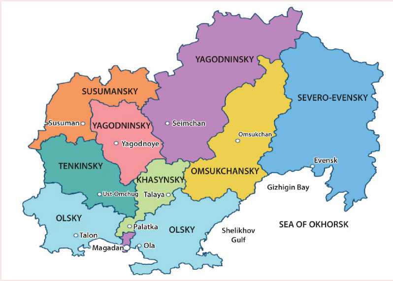
Source: Website of the Magadan Oblast Government. Available at:
Table 1. Characteristics of the “Arctic” municipalities of the Magadan Oblast
expressions of the criterion in the Arctic regions of Russia (if available) or with the actual values of the indicators (if the quantitative criterion is absent).
The municipal formations under consideration are characterized by a low number and density of population and are located at a distance from the
Table 2. Geographical coordinates of the Arctic territories of the Russian Federation and municipalities of the Magadan Oblast
RF constituent entity/municipal formation Northern latitude, degrees Chukotka Autonomous Okrug 61.8–71.5 Yamalo-Nenets Autonomous Okrug 63.3–73.5 Municipal formation “Momsky District” (Republic of Sakha (Yakutia)) 64.0–67.8 Rural settlement “Settlement of Yukta” (Krasnoyarsk Krai) 63.3 Rural settlement “Settlement of Kislokan” (Krasnoyarsk Krai) 63.0 Rural settlement “Settlement of Surinda” (Krasnoyarsk Krai) 62.0 Severo-Evensky Urban Okrug 60.5–66.0 Omsukchansky Urban Okrug 60.8–64.8 Srednekansky Urban Okrug 62.0–65.4 Susumansky Urban Okrug 62.0–64.5 Source:
Figure 3. The boundary of the cryolithozone of the Russian Federation
СЕВЕРНЫЙ ЛЕДОВИТЫЙ ОКЕАН
Х^г
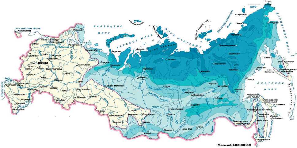
Distribution of permafrost
Isolated, sporadic and discontinuous distribution of permafrost with average annual temperatures (Tav) from +3 to –1°C and permafrost thickness (PT) from 0 to 100 m
Continuous distribution of permafrost:
T av from –1 to –3°C; T av from –3 to –5°C;
PT from 50 to 300 m PT from 100 to 400 m
T av from –5 to –9°C; T av below –9°C;
PT from 200 to 600 m PT from 400 to 900 m and lower
Areas without permafrost Southern border of the cryolithic zone
Source: Surprises of “eternal ice”. Available at:
Table 3. Average monthly temperature in July in a number of regions included in the AZRF and in the Magadan Oblast, °С
Region § ОС s CD ОС a ОС a ОС CD ОС Arctic regions* Nenets Autonomous Okrug 10.1 2 10.0 3 8.1 2 14.9 10 9.7 2 Murmansk Oblast 13.8 8 14.7 8 10.0 3 13.6 6 11.2 4 Yamalo-Nenets Autonomous Okrug 13.3 6 9.7 2 13.3 9 14.5 8 15.2 20 Taymyrsky Dolgano-Nenetsky District 5.7 1 4.7 1 7.9 1 6.5 1 6.9 1 Chukotka Autonomous Okrug 10.9 3 11.1 4 12.4 6 10.3 2 10.8 3 Magadan Oblast, including urban okrugs**: 13.6 7 16.7 13 15.0 16 12.3 3 12.7 7 Severo-Evensky 12.1 – 14.5 – 15.7 – 12.3 – 12.2 – Omsukchansky 16.3 – 23.7 – 15.5 – 13.4 – 13.6 – Srednekansky 18.6 – 20.7 – 18.3 – 15.2 – 15.4 – Susumansky 16.0 – 23.5 – 15.9 – 12.9 – 13.1 – Sources: Russian Statistical Yearbook: Statistics Collection. Rosstat. Moscow, 2006; 2016, 2018, 2020. * Regions and municipalities that are geographically completely related to the Russian Arctic. **Data of the average July isotherm (source: ; regional center (Tab. 1). The population of the districts is decreasing annually. In the development of a rich natural resource potential (Galtseva, Sharypova, 2020), the drive-in drive-out work practices prevail.
Uniformity of geographical and climatic characteristics of municipalities of the Magadan Oblast and the Arctic territories of the Russian Federation
-
a) Geographical location . The municipal formations are located in the range of the northern latitude close to the interval of the northern latitude of the territories of the AZRF. That is, the northern borders of urban okrugs of the Magadan Oblast are located above the southern points of some territories of the AZRF (Tab. 2) .
-
b) Extreme natural and climatic conditions. Magadan Oblast districts are characterized by almost ubiquitous permafrost (Fig. 3) .
Table 3 provides information on the average monthly temperature in July in the RF Arctic territories and the data on the Magadan Oblast and its municipal formations. Only two RF constituent entities out of those, whose entire territory is in the Arctic, meet the criterion of the average July temperature ranging from 10°С and below. The Magadan Oblast, including three of the four districts we are considering, is characterized by the temperature conditions that in some years are worse, in comparison with certain Arctic regions.
There is no clear trend of an increase or decrease in the July temperature. From 2005 to 2019, the average July isotherm in the Magadan Oblast as a whole decreased by 1°С. In the Omsukchansky, Srednekansky and Susumansky urban okrugs of the Magadan Oblast, there is a decrease in the average July isotherm by 3°С. In 2017, the Magadan Oblast ranked third among RF constituent entities in terms of the average monthly temperature in July.
-
c) Ultraviolet deficiency. Half of the territory of the Magadan Oblast, including the areas under consideration, is located within the boundaries of
Figure 4. Cartographic diagram “Subzones of ultraviolet deficiency”
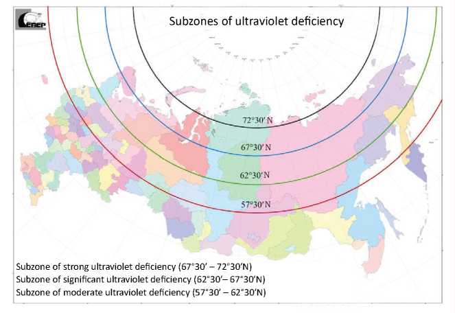
Source: Zhukov M.A., Krainov V.N. (2018). Opredelenie sostava Arkticheskoi zony Rossiiskoi Federatsii [Determining the composition of the Arctic zone of the Russian Federation]. Syktyvkar: Komi respublikanskaya akademiya gosudarstvennoi sluzhby i upravleniya.
Figure 5. Cartographic diagram “The influence of the natural conditions of the territory of the Russian Federation on the living conditions of the population (integrated map)”
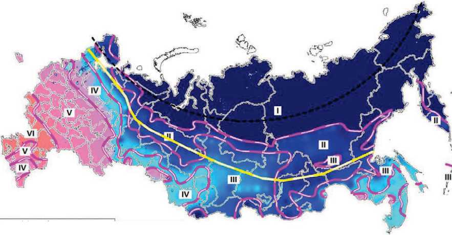
Natural discomfort zones
I – Very unfavorable
II – Unfavorable
III – Relatively unfavorable
IV – Relatively favorable
V – Moderately favorable
VI – Zone of climatic optimum
Natural discomfort points в 4.9 and more
□ 4.9–3.9
□ 3.8–3.4
3.4–2.0
less than 2.0
Supposed border of the North of Russia
Source: Zhukov M.A., Krainov V.N. (2018). Opredelenie sostava Arkticheskoi zony Rossiiskoi Federatsii [Determining the composition of the Arctic zone of the Russian Federation]. Syktyvkar: Komi respublikanskaya akademiya gosudarstvennoi sluzhby i upravleniya.
Figure 6. The “cost of adaptation” indicator
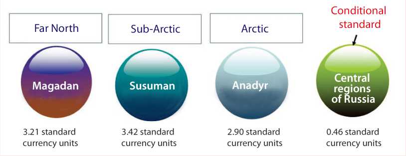
Source: Lugovaya E.A., Aver’yanova I.V. (2020). Assessing tension coefficient of body adaptation reserves under chronic exposure to factors existing in polar regions. Health Risk Analysis , 2, 101–109.
the subzone of significant ultraviolet deficiency (62.3–67.3°N), which allows them to be included in the group of circumpolar (Arctic) territories (Fig. 4) .
-
d) Bioclimatic characteristics . Due to the harsh natural and climatic conditions, the Magadan Oblast belongs to a very unfavorable zone for human habitation with an index of 4.9 points or more (Fig. 5) .
According to researchers at the Scientific Research Center “Arktika”, Far Eastern Branch of the Russian Academy of Sciences, the discomfort of living in the Magadan Oblast, determined by the “cost of adaptation” indicator 11 , is higher (Maksimov, 2006; Lugovaya, Averyanova, 2020) than in Chukotka Autonomous Okrug included in the Arctic (Fig. 6) . The indicator is calculated taking into account natural-climatic, economic-geographical, socio-economic and biomedical factors.
We have already noted that in the Pacific sector, the zone of the Far North is somewhat “sliding” to the south. As a result, the living conditions in the Pacific sectors of the Arctic and sub-Arctic are more difficult than in the Yakut sectors (Leonov, 2013).
Similarities of socio-economic development issues
The districts of the Magadan Oblast and the Arctic regions are united by the similarity of socioeconomic problems that are due to geographical and climatic conditions.
Russia’s Arctic territories can be divided into a group of old industrial regions (Murmansk Oblast, Arkhangelsk Oblast, Krasnoyarsk Krai – Norilsk Industrial and Taimyrsky municipal districts) and a group of regions of relatively recent large-scale industrial development (Nenets Autonomous Okrug, Yamalo-Nenets Autonomous Okrug, Arctic uluses of the Republic of Sakha (Yakutia), Chukotka Autonomous Okrug). The beginning of the development of the Arctic territory and the age of the branches of specialization influence modern socio-economic development in the region (Gal’tseva et al., 2015). The main branches of industrial specialization of the Russian Arctic are mining, ferrous and non-ferrous metallurgy, to a lesser extent – fishing and woodworking industries (Chanysheva et al., 2021). The main characteristics of the current socio-economic situation of the Magadan Oblast, reflecting the economic criteria for the allocation of the AZRF, are as follows:
-
a) single-industry economy based on the extraction of gold and silver and dependent on the
situation on global raw materials markets, the future of which is also associated with the development of mineral resources;
-
b) low purchasing power of high per capita incomes in the region, taking into account the significant amount of the subsistence level (Tab. 4) , which reduces the standard of living and causes migration outflow (Gal’tseva et al., 2020; Belevskikh, Tvahova, 2021);
Table 4. The subsistence level of the ablebodied population in the regions of the AZRF and the Magadan Oblast
Region IV quarter 2020, rubles Rank among the RF constituent entities Arctic regions Nenets Autonomous Okrug 22971 2 Murmansk Oblast 18438 7 Yamalo-Nenets Autonomous Okrug 17407 6 Chukotka Autonomous Okrug 24711 1 Magadan Oblast 22027 4* * Kamchatka Krai ranks third (22535 rubles). Source: Federal State Statistics Service. Available at:
Access of municipal districts to the coast of the Arctic Ocean
A number of Arctic territories already included in the list do not have access to the Arctic Ocean. However, the water system of the Magadan Oblast is part of the Arctic water system (85% of the region is occupied by the territory of the Kolyma catchment area, which falls into the Arctic Ocean). With the intensification of traffic along the NSR, river navigation and road transportation will develop, which will change the pattern of deliveries to remote Arctic and northern regions of the Far East. The Magadan ice-free seaport adapted for year-round transportation of goods, along with highways, taking into account winter roads, make it possible to carry out the main delivery of goods to the Arctic via meridional transport routes through the Magadan Oblast (Baklanov, Romanov, 2015).
There are grounds to include the city of Magadan into the strongholds of the NSR of the “second order”. The creation of modern infrastructure in the NSR and meridian directions will contribute to the implementation of resource projects, which, as a result, will provide an additional impetus to the socio-economic development of the Arctic and Arctic regions of the North-East of Russia.
Connectivity of the municipalities of the Magadan Oblast and the Arctic regions of the Far Eastern Federal District (Far Eastern Federal District) with a single infrastructure
Currently, the Kolyma Highway and the Magadan seaport are already being used to supply cargo to the Arctic regions of the Republic of Sakha (Yakutia). The Magadan Oblast and the Republic of Sakha (Yakutia) are connected via the current Federal Automobile Highway R504 “Kolyma” with a length of 2,032 km, of which 1,197 km go through the territory of the Republic of Sakha (Yakutia), and 835 km – through the Magadan Oblast. The construction of the Kolyma – Omsukchan – Omolon – Anadyr highway with a length of more than 1,800 km continues. The highway should provide year-round automobile communication between the Magadan Oblast and Chukotka Autonomous Okrug.
The electric power of the Kolyma power plants is supplied to Oymyakonsky ulus of the Republic of Sakha (Yakutia). The potential of two hydroelectric power plants (one of them – Ust-Srednekanskaya – is located in Srednekansky Urban Okrug) with excess capacity is necessary for the implementation of large energy-intensive projects for development of natural resources in Chukotka Autonomous Okrug. Currently, a project for the construction of a power line from the Magadan Oblast to Chukotka Autonomous Okrug is being discussed (Fig. 7) .
Figure 7. Interconnectedness of the Magadan Oblast and Chukotka Autonomous Okrug via a unified transport and energy infrastructure
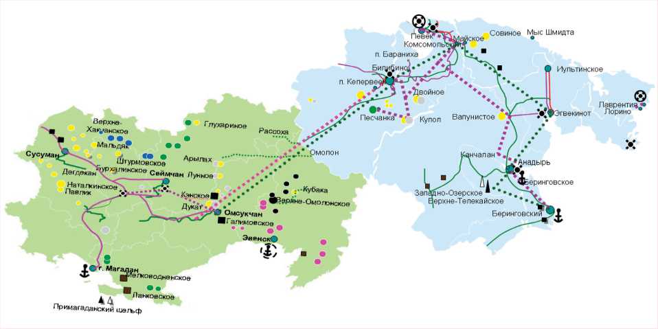
Source: compiled on the basis of Esri CIS spatial data.
Let us summarize the results of the comparisons made on the natural and economic criteria for inclusion of territories in the AZRF according to the algorithm proposed by M.A. Zhukov (Tab. 5, 6) .
According to natural criteria, we observe an almost complete compliance of the characteristics, with the exception of the criterion of location of municipal districts within the CAFF boundaries. According to economic criteria, we note almost complete compliance here as well, with the exception of the criterion of proximity to the seas of the Arctic Ocean. It is worth noting that the territories already included in the Russian Arctic also do not meet all the criteria (Zhukov et al., 2017a).
The development of promising facilities in the considered urban okrugs will significantly improve the socio-economic situation throughout the Magadan Oblast due to an increase in industrial production and tax collection, a decrease in the subsidization of the regional budget, and an increase in the number of population. However,
Table 5. Comparison of the characteristics of Magadan Oblast territories with the natural criteria for inclusion in the AZRF
|
Urban okrug |
Subzones of UV deficiency (northern latitude) |
Bioclimatic characteristics of discomfort |
Arctic and Sub-Arctic landscapes |
||||||
|
J1 |
J1 E |
1 -S о if |
® E о -^ 5 о |
ft |
о § |
||||
|
Severo-Evensky |
- |
+ |
- |
- |
- |
+ |
+ |
+ |
- |
|
Omsukchansky |
- |
+ |
- |
- |
- |
+ |
+ |
+ |
- |
|
Srednekansky |
- |
+ |
- |
- |
- |
+ |
+ |
- |
- |
|
Susumansky |
- |
+ |
- |
- |
- |
+ |
+ |
+ |
- |
Source: own assessment according to M.A. Zhukov’s algorithm (Zhukov et al., 2017a).
Table 6. Comparison of the characteristics of Magadan Oblast territories with the economic criteria for inclusion in the AZRF
|
Urban okrug |
Arctic specifics of economic systems |
||||||
|
cc
СУ £ |
e' ё ^ |
™ 8 — О S' E ^ co |
E I 1^1 |
8 § i2 8 s ё > ё S ” ё = i ° 8 § ё ^ ° ® g |
^ о E 1 § 1 О 2 1 — 8 c” § 8 CZ) "o N о "о ^ |
E ~ ё e 1 ” |
|
|
Severo-Evensky |
+ |
- |
+ |
+ |
+ |
+ |
+ |
|
Omsukchansky |
- |
- |
+ |
+ |
+ |
+ |
+ |
|
Srednekansky |
+ |
- |
+ |
+ |
+ |
+ |
+ |
|
Susumansky |
+ |
- |
+ |
+ |
+ |
+ |
+ |
Source: own assessment according to M.A. Zhukov’s algorithm (Zhukov et al., 2017a).
Table 7. Changes in project indicators relative to the basic option
Effects of the inclusion of northern urban okrugs of the Magadan Oblast in the AZRF
Investment effects. Let us evaluate the effectiveness of the current state Arctic preferences 12 for the investor on the example of the development of Yuzhno-Omolonsky iron ore area, a large promising facility in Severo-Evensky Urban Okrug. The object is 160 km away from the coast. The import of goods and the export of finished products require building a road and a seaport/berth (currently there is an offshore discharge of cargo there), power supply requires constructing a power line or a power plant.
AZRF residents are provided with tax benefits (land, profit, mining, property); benefits for insurance premiums; exemption from customs duties; simplification of legal regulation of labor relations. Taking into consideration the fact that income tax benefits are valid for 10 years from the moment of the income receipt, we made a comparative assessment of the effectiveness of the project implementation in different tax and customs regimes over the same period. The evaluation results indicate a reduction in costs by 16.2%, a reduction in the payback period of costs by almost 2.2 years (Tab. 7). In the conditions of the Special Economic Zone (SEZ) regime in the Magadan Oblast13, cost savings will be only 7.5%, and the payback period is 1.4 years lower than the base option. Thus, using the benefits for investment projects in the AZRF, the investor will be able to reduce costs compared not only with the basic version of tax and customs payments, but also with the benefits in force until 2025 in the conditions of the SEZ in the Magadan Oblast.
When the proposed territories are included in the AZRF, the following socio-economic effects for the region are expected in the course of development of large deposits:
-
– high-performance jobs will be created;
-
– population outflow (including due to the influx of migrant workers) will be curbed;
-
– tax revenues will be increased;
-
– infrastructure will be created so as to develop deposits that will be used by related industries and inhabitants (roads, power lines, etc.);
– wages will grow due to the application of a higher locality pay rate and northern allowances. It will be fair for Magadan Oblast districts to have the same current locality pay rate (2) and the amount of northern allowances (100%) as the nearest Arctic region – Chukotka Autonomous Okrug.
As a result, wages will increase 1.2-fold in Susumansky, Srednekansky and Omsukchansky districts, and 1.1-fold in Severo-Evensky District.
Ethnic effects will be expressed in support for the development of traditional economic sectors of the indigenous small-numbered peoples of the North, since in three of the four urban okrugs of the Magadan Oblast under consideration (Severo-Evensky, Omsukchansky, Srednekansky) the share of ISNPs is from 10 to 75% of the total population. The inclusion of the municipalities under consideration in the AZRF will increase the effectiveness of addressing such tasks as supporting ethno-cultural projects, infrastructure development as a way to retain ISNPs in traditional industries, increasing the prestige of traditional economic sectors, etc. (Tishkov et al., 2016; Gal’tseva et al., 2017).
Conclusions
In the course of the study, we substantiated the economic feasibility of including four urban okrugs of the Magadan Oblast in the list of Arctic territories of the Russian Federation. Due to the fact that Russia has no legally established criteria for including territories in the AZRF and their values, the expediency of such inclusion is based on identifying the compliance of the climatic, economic characteristics and specifics of economic activity of the considered urban okrugs with the features of AZRF regions, namely:
– geographical location of areas in the permafrost zone in combination with the boundaries of northern latitude, landscapes, the average July isotherm;
– location in a very unfavorable zone of natural discomfort (4.9 points or more) ; due to a harsh climate, the living conditions in these areas are among the most severe ones;
– interregional connectivity and unity of economic complexes with territories already included in the AZRF , primarily Chukotka Autonomous Okrug and the Republic of Sakha (Yakutia);
– participation in the development of the NSR due to the active development and use of meridional transport routes with a non-freezing port and rivers of the Magadan Oblast.
The inclusion of four municipalities of the Magadan Oblast in the Arctic is substantiated taking into account the significant infrastructural and unique natural resource potential.
The multifactorial extremity and the fact that, according to most parameters, the considered urban okrugs of the Magadan Oblast are in much worse conditions than the regions of Russia already classified as Arctic territories can be considered the basis for changing the southern border of the AZRF. The inclusion of four municipal formations of the Magadan Oblast in the Arctic will provide the following benefits:
-
– ensure the unity of the natural and economic systems of the Magadan Oblast and neighboring regions – Chukotka Autonomous Okrug and the Republic of Sakha (Yakutia);
-
– attract investors for the implementation of major projects in the field of subsoil use in the Arctic with the help of preferential conditions;
-
– improve the quality of life for those living and working in municipal formations of the Magadan Oblast;
-
– stabilize the population of the territory at a level sufficient to reduce social tension and promote sustainable development;
-
– provide support for the implementation of social projects ;
– promote the development of traditional economic sectors that ensure increased employment and self-employment of the indigenous small-numbered peoples of the North living in these urban okrugs.
After their inclusion in the AZRF, the regions of the Magadan Oblast will contribute to the fulfillment of Arctic functions – those related to mining, transport, and preservation of the economic paradigm of the indigenous peoples of the North.
