Technology for monitoring and inventory of forest resources based on laser location, digital aerial photography and satellite geopositioning

Author: Danilin Igor M., Medvedev Eugene M.
Journal: Журнал Сибирского федерального университета. Серия: Техника и технологии @technologies-sfu
Article in issue: 3 т.4, 2011.
Free access
The use of the newest methods and technologies of airborne laser location, high resolution digital photography and the global positioning satellite systems, provides principally new opportunities for remote sensing monitoring and inventory of forest resources. High efficiency of laser location (more than 200 thousand pulses/measurements per second) in combination with centimeter spatial resolution of digital aerial photography, high (about 10-15 cm) accuracy for coordinate definition of trees and tree stands morphostructural parameters by satellite geopositioning systems, as well as three-dimensional visualization of the remote sensing data at geoinformation systems, allows to developing effective algorithms for research of forest resources structure and dynamics, guaranteeing a real time automatic extraction of forest inventory parameters. Development and application of such high-end technologies to aerospace forest monitoring is critical and essential for boreal zone and, in particular, for regions of Siberia, where traditional approaches of forest inventory to be used today are not effective, do not provide required accuracy and are highly timeand funds consuming.
Laser location, digital aerial photography, satellite geopositioning, monitoring and inventory of forest resources
Short address: https://sciup.org/146114588
IDR: 146114588 | UDC: 629.78;
Технология мониторинга и инвентаризации лесных ресурсов на основе лазерной локации, цифровой аэрофотосъемки и спутникового геопозиционирования
Использование новейших методов и технологий авиационной лазерной локации, цифровой аэрофотосъемки сверхвысокого разрешения и спутникового геопозиционирования обеспечивает принципиально новые возможности для дистанционного мониторинга и инвентаризации лесных ресурсов. Высокая эффективность лазерной локации (более 200 тысяч импульсов/ измерений в секунду) в сочетании с сантиметровым пространственным разрешением цифровой аэрофотосъемки, высокой (порядка 10-15 см) точностью определения координат объектов и морфоструктурных параметров деревьев и древостоев в системах спутникового геопозиционирования и трехмерной визуализацией данных дистанционного зондирования в геоинформационных системах позволяет разработать эффективные алгоритмы исследований структуры и динамики лесных ресурсов, гарантируя автоматическое извлечение лесотаксационных показателей в режиме реального времени. Развитие и применение таких высокоэффективных технологий аэрокосмического мониторинга лесов является критическим и высоко значимым для бореальной зоны и, в особенности, для регионов Сибири, где используемые сегодня традиционные подходы в лесоинвентаризации не эффективны, не обеспечивают требуемой точности, высоко затратны по стоимости и времени выполнения.
Text of the scientific article Technology for monitoring and inventory of forest resources based on laser location, digital aerial photography and satellite geopositioning
Securing reliable and efficient information about status and dynamics of forest lands at the contemporary practice of forest use and monitoring, is an urgent problem, considering natural resources as well as environmental and nature protection points of view.
In solving this problem in many countries of the world as well as in Russia at present time more actively is in use laser location, digital aerial photography and satellite geopositioning, which are major constituting part of geomatics – the newest integral direction for development of remote sensing
methods of the Earth (aerial- and space survey), geoinformation technologies, digital photogrammetry, cartography and telecommunications.
Those advanced and highly effective methods today find wide application in many branches of economy, in fact being information basis for ecological monitoring, systems of gathering, processing and data analysis systems, land- and forest planning, cadastre of natural resources and by accuracy and economical efficiency exceeds the other methods of studying and measuring parameters of the earth cover and natural systems [4-20, 22-24].
Intensively developing laser scanning of forest resources in Scandinavian countries shows high efficiency of laser technology for national inventory, accurate prediction of the basic forest statistics, identifying species of individual trees with generating 3D surface and vegetation models [12, 13, 16, 17, 23].
Several experimental works had been successfully implemented in North America confirming great challenges for estimating tree height via LiDAR in closed-canopy forests, regional boreal forest canopy and landscape attribute estimation, land use change and biomass characterization in combination with the use of satellite imagery [10, 19, 20, 24].
An applicable lidar-based approach integrated with aerial photos to estimate the stem volume of alpine forest stands in Austria and Germany has been recently completed, conforming near on ground instrumental accuracy on getting basic forest biometrics [11, 22].
The recent findings on airborne lidar and digital photo data processing and information extraction using mathematic filtering and morphological methods shows optimistic prospects for automatization of the data processing and laser scenes’ thematic interpretation and mapping [1-3, 8, 9, 14].
Methods and technologies
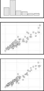
The high-end aviation laser location, digital photographic and satellite geopositioning systems and technologies intensively develops and as of today have a laser scanning frequency more than 200 thousand pulses (measurements) per second (Fig. 1).
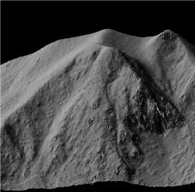
The highest density for laser scanning pulses makes up 1 pulse per 5–7 cm on the surface, with accuracy for measuring geometric parameters of the ground objects and vegetation morphostructural elements at plan and profile projections at about ± 5–10 сm. Accuracy for satellite positioning of lines and forest compartment edges, sample plots, separate trees and morphostructural elements of their stems and crowns, including under crown space, practically is not limited and depends on technical parameters of the GPS/GLONASS instruments [1, 14, 15] (Fig. 2, 3).
Tools for spatial and detailed displaying contours and relief of the terrain, vegetation and base for preliminary tracing routs for laser and digital aerial photography, satellite scenes gotten by modern optical-electronic systems as: Landsat, Resurs-DK, Ikonos, OrbView-3, WorldView-2, GeoEye-1 or other systems of high- and ultrahigh resolution, interpreted by main parameters of vegetation cover might be in use [4-6, 14, 20, 24].
And with it, structure, volumetric tree- and tree stand indices, phytomass more reliably and precisely are determined by laser-location data («laser portraits»), integrated with digital geotransformed aerial photographs, based on digital terrain models (DTM) and forest canopy field patterns, which are generated from the initial laser location data by filtering (separating) laser pulses, reflected from the ground surface and vegetation, by means of the ground pulses’ interpolation with – 327 –
a
b
c
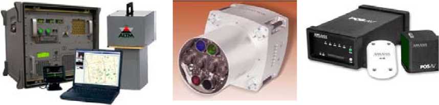
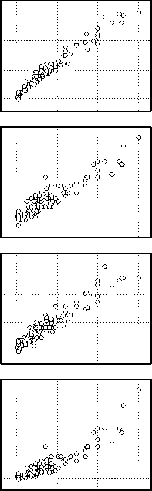
Fig. 1. Technical devices and components for technology of forest monitoring based on laser location and digital aerial photography: ( a ) universal aerial surveying laser topographic system Optech ALTM 3100 – supplies laser-location data. Purpose: Digital Terrain Models, contour’s allocation, data interpretation; ( b ) large-format digital photogrammetric aerial camera Vexcel UltraCamXp – supplies digital aerial photographs with ultrahigh (centimetre) resolution. Purpose: traditional; ( c ) system for direct geopositioning and orientation of aerial photography sensors Applanix POSAV – supplies elements for external orientation of digital aerial photographs and laser-location data. Purpose: direct geopositioning (geoaffixment)
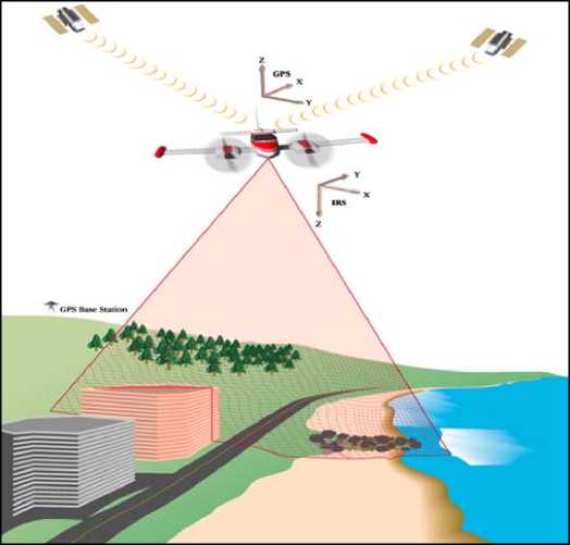
Fig. 2. The principle of laser location, digital aerial photography and satellite geopositioning
the following triangulation of pulses reflected from vegetation in systems of differential satellite positioning GPS, GLONASS [1, 14]. With processing and analyzing laser-location data and digital aerial photographs mathematic morphology methods and concept of set- and fuzzy set theory are in use [2-4, 14, 21].
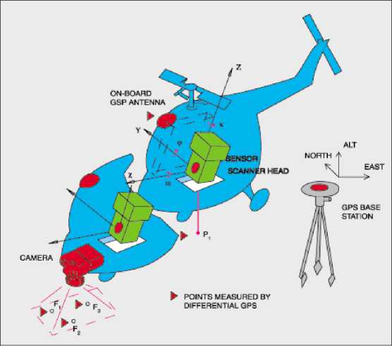
Fig. 3. Layout drawing for onboard placement laser location, digital photography and GPS devices and instruments.
a b
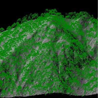
Fig. 4. Three-dimensional visualization of forest vegetation ( a ) and relief of the terrain under tree canopy ( b ) by laser-location data
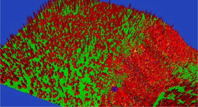
Fig. 5. Digital polygonal model of larch stand, generated by laser-location data
Results and discussion
In some works implemented earlier in Russia and in the other countries [4-14, 16-20, 22-24], it had been shown that accuracy of timber stock and forest biomass estimation, as well as by aerial survey methods, is possible to increase up to 5–7 % with the use of morphological classification and allometric correlation between tree biometrics.
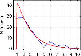
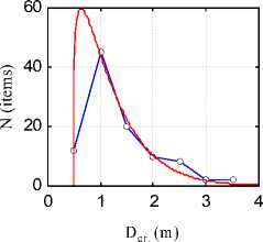
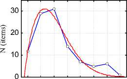
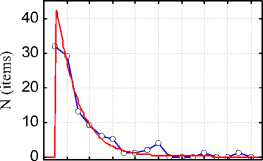
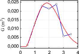
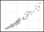
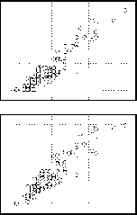
Our research, completed at Krasnoyarsk territory, shows that more adequately and effectively structure of ground surface and vegetation cover with the use of DTM, generated by laser location and digital aerial photography, are identifying by characteristics of a tree distribution lines of the main morphometric indices – diameter and height, vertical and horizontal crown extent, which by turn are closely intercorrelated. And with it, volumetric and weight tree- and tree stand parameters are approximated with high accuracy by allometric functions through their morphometric indices (Fig. 6-8, Table 1).
It’s generally known, that construction of a tree distribution lines by their morphometric indices traditionally supposes completing time- and labor-consuming ground biometric procedures, measuring operations and tree recalculations (continuous or selective), which one requires substantial financial expenditures. At the same time, laser location method combined with digital aerial photography, satellite geopositioning and integrated to geoinformation systems (Fig. 9, 10) allows to performing pixel instrumental-measuring forest inventory based on precision satellite geodesy and detailed topographic survey, to study forest cover dynamics, horizontal and vertical structure of a tree stands, to reconstruct tree line distributions by any morphometric indicators, and to calculate required forest inventory parameters and forest biomass automatically, with high accuracy at large areas (up to 500– 700 square km per one working day).
Assessment of timber stock and forest phytomass by laser location and digital aerial photography data at every case study brings to identification of base regulations for the forest compartments and to determination of correlations between tree stem volumes, tree- and crown height and diameter, – 330 –
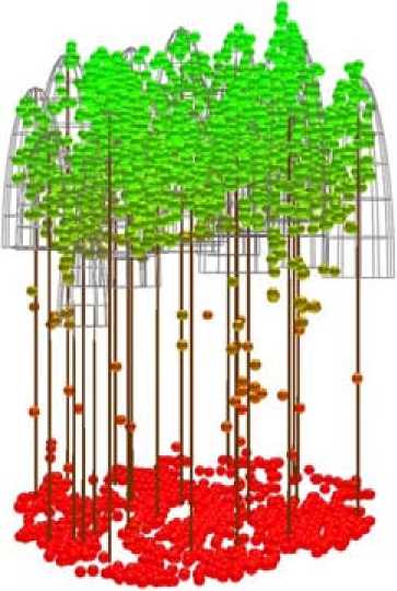
Fig. 6. Digital reconstruction of larch stand’s morphological structure, implemented by laser location data
D 1.3 (cm)
L cr. (m)
H (m)
S cr. (m2)
D cr. (m)
Fig. 7. Distribution of larch trees by morphometric indices of stems and crowns ( – ), approximated by Weibull function ( – ): N – number of trees; D 1.3 – tree stem diameter 1.3 m above its base; H – tree height; D cr. – tree crown diameter; L cr. – tree crown length; S cr. – tree crown area; G – tree stem cross sectional area 1.3 m above its base (G f (D cr. ))
D 1 . 3

H
D cr.
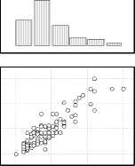
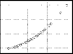
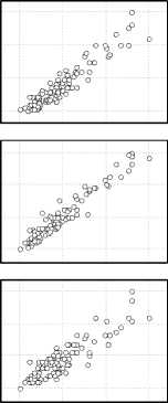
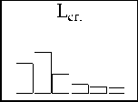
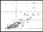
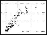
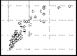
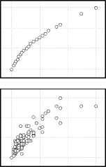
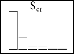
Fig. 8. Overlap matrix for distribution histogram and correlated scattering of the main morphometric indices of larch tree stand
Table. Regression coefficients for morphometric indices and phytomass of larch trees
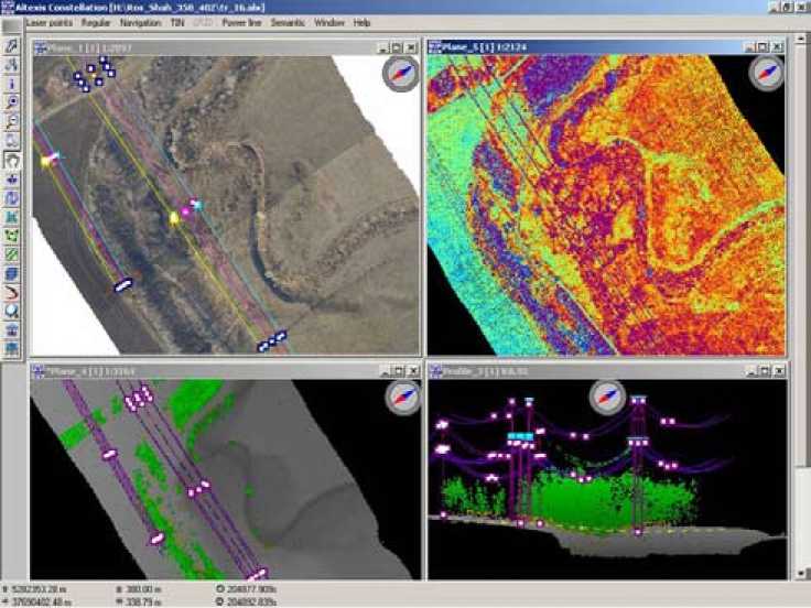
Fig. 9. Combined visualization and processing of laser location and aerial digital photograpy data at Altexis 2.0 working window
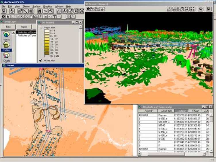
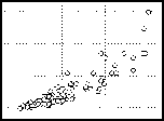
Fig. 10. Two-dimensional and three-dimensional GIS-mapping of the surveyed terrain by laser location and digital aerial photography and phytomass, which one constitutes 87–99 % variability for different phytomass fractions – stems, crown skeleton and needle [4, 14].
Conclusion
Results of the practical approbation of aviation laser location technology combined with digital aerial photography and satellite geopositioning, integrated to geoinformation systems, give us an evidence for its high availability for the purpose of forest cover and disturbance analysis and simulation, an inventory, on-line ecological monitoring, information securing cadastre of forest lands and forest use control. This high-tech effective method provides remote sensing evaluation of forest resources, their status and dynamics, minimizing field works and significant saving time and financial funds. Cost efficiency of the technology is ensured by principal increasing accuracy of the measurement results and a possibility of their repetition (verification), significant lowering of the job implementation labour-intensiveness and complexity (as for a filed one, as well as for laboratory interpretation), at the expense of high level of automation getting and processing laser location and digital aerial photography data. Amount of a field works is minimized with it and needs only calibration of laser location results and maintenance of aerial photography data interactive interpretation.
