The basis for the age of the Bayantumen formation sediments distributed along the border of Mongolia (Choibalsan Sum area of Eastern province)
")
Author: Bat-erdene M.
Journal: Природа Внутренней Азии @nature-inner-asia
Section: География
Article in issue: 1 (27), 2024.
Free access
Bayantumen Formation sediments occupy 18.2 per cent of the area of the Ovoot Tolgoi-50 project, which covers the Choibalsan, Chuluun Kohot, and Gurvanzagal districts of Dornod Province, or 523.8 km2. This sediment is widely distributed in the Eastern Mongolia region. The Ovoot Tolgoi-50 project area borders with China in the southeast. Previous researchers mapped the sediments of the Lower Cretaceous Bayantumen Formation along the border of Mongolia, and Jurassic volcanogenic and volcanic sedimentary rocks adjacent to it in Chinese territory. As part of the research work of the Ovoot Tolgoi-50 project, we have taken absolute age samples from the volcanics of the lower member of the Bayantumen Formation and determined by the uranium-lead method. The age was determined to be 141 ± 1.7 million years, corresponding to the Valanginian-Gotian period (Kt). Lower Cretaceous Valanginian-Goterian shells were found in the acid metasands of the lower member of the Bayantumen Formation, which confirmed the basis for the age of the sediments.
Bayantumen formation, animal and plant remains, absolute age, eastern mongolia
Short address: https://sciup.org/148328990
IDR: 148328990 | UDC: 574.47 | DOI: 10.18101/2542-0623-2024-1-89-98
Обоснование возраста баянтуменских отложений, распространенных вдоль границы Монголии (район Чойбалсан-Сум Восточной провинции)
Баянтуменские отложения занимают 18,2 % площади комплекса Овоот Толгой-50, охватывающего Чойбалсанский, Чулуун-Кохотский и Гурванзагальский районы провинции Дорнод, или 523,8 км2. Этот осадок широко распространен в регионе Восточной Монголии. Территория комплекса Овоот Толгой-50 граничит с Китаем на юго-востоке. Предыдущие исследователи картировали отложения нижнемелового Баянтуменского образования вдоль границы Монголии, а также прилегающие к ней юрские вулканогенные и вулканогенно-осадочные породы на территории Китая. В рамках научно-исследовательских работ проекта Овоот Толгой-50 из вулканитов нижней пачки баянтуменского образования были отобраны образцы абсолютного возраста и определены уран-свинцовым методом. Возраст был определен как 141±1,7 млн лет, что соответствует валанжинско-готскому периоду (КЦ В кислых метапесчаниках нижней пачки баянтуменского образования обнаружены нижнемеловые валанжинско-готерийские раковины и подтвержден возраст отложений.
Text of the scientific article The basis for the age of the Bayantumen formation sediments distributed along the border of Mongolia (Choibalsan Sum area of Eastern province)
The “Ovoot Tolgoi-50 project spans an area of 2 878.05 km², covering the Choi-balsan, Chuluunkhoroot, and Gurvanzagal districts of Dornod Province, as delineated by M-50-88-A, B, G; M-50-89-B, G-a, c; and M-50-100-B on a 1:50,000 scale map. Geological mapping and general exploration were conducted on planes M-50-101-A, B-a, B-b, c. According to the tectonic classification by O.Tumartogoo (2017), the majority of the research area falls within the Ereen Davaa tectonic region, with a smaller portion belonging to the riftogenic zone (block) of Doch River (Fig. 1).
Origin of the Name
Volcanogenic sequences that are widespread in Choibalsan City and Gurvanzagal Sum area of Dornod Province were first identified by T. Binderya (1993) and P. Hosbayar (1995) and named Bayantumen after the old name of Choibalsan city.
Previous Study
The Bayantumen Formation sediments which are distributed around Sum Lake in Gurvanzagal Sum, Dornod Province and conformably cover the sediments of the Lower Cretaceous Ochirkhuret Formation and the Church Lake Formation sediments (Fig. 2). The thickness of the sequence is 500–2000 m. Following fauna have been found in the sequence — Limnocyrena elongata Marts, L. subplana (Reis), Campolema conica Marts., Arguniella sp, conchostrac — Bairdestheria huzitai Kob. et Kus., molluscs such as B. sinensis (Chi), Brachugrapta sibirica (Kras.), Lycoptera fralis, and fish fossils such as Terrindusia reisi Suk found in the sequence. The Bayantumen Formation consists of volcanic rocks of various compositions includingtrachyrhyolite, rhyolite, rhyodacite, trachybasalt, ignimbrite, felsite, pearlite, andesibasalt, andesite, their tuff, tuff sandstone, tuff conglomerate, siltstone, and clay shale.
In Russia, the Lower Cretaceous sediments are divided into the Turgin Suite and divided into 3 sub-suites. The volcanogenic-terrigenous sediments of the Turgin Suite consists of sandstone, siltstone, and mudstone layers, and contain several lava flows of 50–100 m thick trachyandesibasalt. This sedimentary layer contains Lower Cretaceous ostracods, conchrusts, molluscs, fishes, and plant remains. The age of basalt is 119–129 Ma /apt-barren/ by the K-Ar method, and 134.8 Ma /valanginian/ by the U-Pb method.
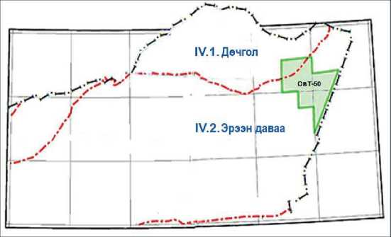
Fig. 1. Tectonic zones, location of the study area [Tumartogoo, 2017]
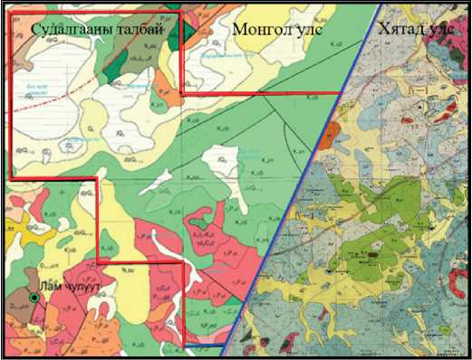
Fig. 2. Geological map of Mongolia and China
The sediments of the Yixian and Jiufotan Formations, which contain a complex fauna and flora of the Jehol Group distributed throughout the Argun Block of Liaoning Province, China, indicate Barremian-Aptian-Albian stages (Fig. 2) [Jung Gou, De-Yu Sun et al., 2019].
Distribution and Outcropping
Bayantumen Formation sediments (Fig. 5) are poorly exposed and are mostly eluvial. in scale, it is rarely found on the top of the hill, forming a ridge (alkaline and acid volcanic as residual cover) (Fig. 3).
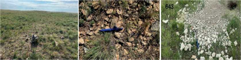
Fig. 3. Sediments of Bayantumen Formation and their state of discovery
Interpretation of aerial and satellite images. The study area has low surface fragmentation, consists thick soil, and intensively developed vegetation cover, low undulating hills, as such the interpretation of aerial and satellite images is poor. The sediments of the Bayantumen Formation are dark brown, brownish brown, and browngrey in the Sentinel image, and light green, greenish grey, brownish brown, pinkish, and light grey in the Aster image with moderate contrast ( see Figure no. 4 ). and aerial photographs show a fuzzy map of light grey.
Lithological composition: Bayantumen Formation consists of dark, brown-grey, darkblue, almond-shaped, porous and massive basalt, andesibasalt, trachyandesite, encrusted andesite, beige, light grey, monolithic rhyolite, tuffels, tuff conglomerate, beige, It consists of light-grey, fine to medium-grained, weakly cohesive conglomerate, gravelite, sand, siltstone, and rarely dark argillite which altered by iron oxide and limonitized.
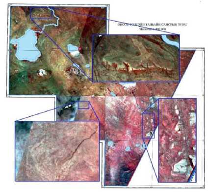
Fig. 4. Bayantumen Formation sediments are visualized in satellite images
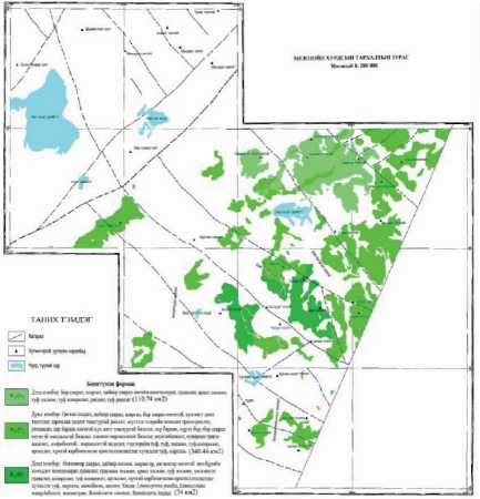
Fig. 5. Distribution scheme of Bayantumen Formation sediments
Research methods
The identification of paleontological samples was carried out by Dr. L. Gereltseg of the Institute of Paleontology of MAS. The absolute age determination was carried out using zircon U-Pb method using LA-ICPMS (Laser Ablation — Inductively Coupled Plasta-Mass Spectrometry) in the laboratory of the Department of Geological Sciences of Taiwan State University. Temorastd 207Pb/235U=1061.8+-2.1 ratio normalized
91 500 and MTstandart was used Petrographic and petrochemical analysis were carried out on selected samples. Samples were prepared by crushing and separating the magnetic fraction and binocularly separating zircon grains from the heavy fraction with a heavy solution of 2.85 g/ml. To ensure the reliability of the measurement results of the separated zircon grains and to increase the accuracy of the measurement, fraction of 100–200 µm was selected and prepared for measurement, and mechanical and chemical polishing was performed. Seperated zircon grains were studied by cathodoluminescence image analysis, and the internal structure was determined, and finally, zircon grains were selected for age determination.
Results
Petrochemical characteristics
We took 17 silicate samples from the volcanogenic rocks of the Bayantumen Formation and utilized samples of similar rocks from the research materials of the Chuluun Khoroot — 50 projects to compare the results. The results are shown in the table below (Table 2).
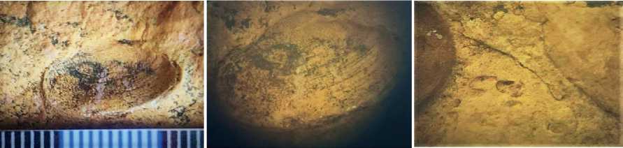
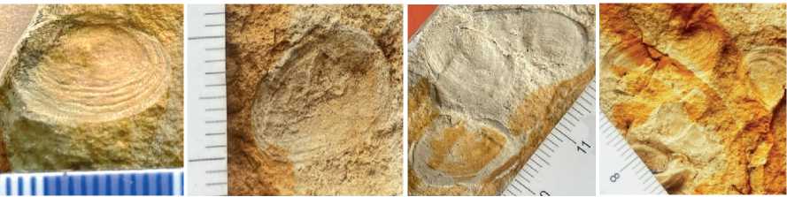
Paleontological results : In the lower member of the Bayantumen Formation, poorly preserved plant stems, shells, and imprints are observed in felsic tuff, tuff sand, and tuff siltstone. Lower Cretaceous Valangian-Goterivian clams Limnocyrena wangshihensis, Limnocyrena pusilla, conchostracs Bairdesteria sinensis, Bairdesteria huzitai were newly discovered were found in the felsic tuff, tuff sandstone, and tuff siltstone /observation point — 180, 5 030 (Fig. 6, 7).
Limnocyrenawangshihensis
Limnocyrena pusilla
Fig. 6. Contained in the sediments of the lower member of the Bayantumen Formation are (op-180) animal remains — fauna (photographed under a microscope, magnification 8 times)
Bairdesteriasinensis (Ац – 5030 - 2)
Bairdesteria huzitai (ац – 5030 - 4)
Fig. 7. Contained in the sediments of the lower member of the Bayantumen Formation are (op – 5 030 — 2, 5 030 — 4) animal remains — fauna
Absolute age
The absolute age obtained from the Bayantumen Formation volcanite (rhyolite) (Sample number: 8 076) was determined to be 141.1±1.7 million years, so the sediment was taken as a Lower Cretaceous Valanginian-Goterivian age.
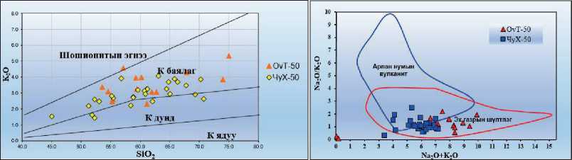
Volcanites of the Bayantumen Formation are alkaline (Fig. 9), K-rich (Fig. 10), trachyandesite, trachydacite (Fig. 8) and belong to continental alkaline volcanogenic (Fig. 11) rocks.
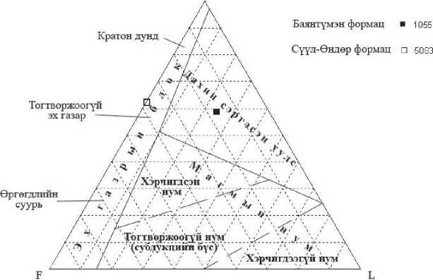
Siltstones of the Lower Cretaceous Bayantumen Formation indicate the conditions of the recovered mountains (Table 3, Fig. 12).
Table 1
List of samples analyzed for absolute age
|
№ |
Sample number |
Coordinates |
List no |
Stone |
Age |
The method |
|
1 |
8076 |
49 P ˚ P 23´4,2˝ 116˚ P 22´24.6˝ |
L-50-89-G |
Rhyolite |
141,1 ± 1,7 |
P 207Pb/ P 235 P U |
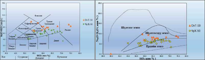
Fig. 8. TAS diagram of the general classification of volcanogenic rocks of the Bayantumen Formation
Fig. 9. Le Metre-(SiO2-K2O+Na2O) correlation diagram of volcanic rocks of Bayantumen Formation
ig 11. Diagram showing the geotectonic tting of volcanic rocks of the Bayantumen of Bayantumen Formation [Le Maitre, 1989] Formation [Miyashiro, 1974]
M.
Bat-Erdene. Basis for the Age of the Bayantumen Formation Sediments Distributed Along the Border
Sum Area of Eastern Province)
Table 2
|
ю о 0© |
04 04 |
04 о" |
ч |
пГ |
о |
in о" |
<ч о" |
S' |
in" |
04 ол о" |
чо ол о" |
О о" |
in Ол |
о о" |
гН Ф О гН |
|
|
40 40 |
ч •X ш |
2 |
г? 4О" |
ш о |
ГЛ |
г? чо" |
oj |
in |
оо 04" |
о" |
чо о" |
о о" |
о |
чо о" |
<4 ф ф гН |
|
|
04 ю гН |
04 0О 2 |
S> о" |
ш" |
Ч |
in 04" |
о 04" |
оо 04 о" |
чо ■о |
СП |
in о" |
оо in ол о" |
СП о" |
о |
in in о" |
о о" |
*4 ф ф гН |
|
0© Н |
04" ш |
40 ш |
04 ш" |
S чо" |
in in |
in ■о in" |
чо ■о |
S |
чо <ч |
о СП о" |
in 04 ол о" |
о" |
СП |
о" |
о о" |
©4 ©4 04 |
|
N о ю гН |
04 04 2 |
оо о" |
04 4О" |
ОО |
о |
ч |
04 оо |
о |
in чо <ч о" |
о о" |
04 <ч о" |
оо <ч |
й |
о о" |
Ф Ф Ф гН |
|
|
N 04 О 0© |
ш 2 |
ОО о" |
о ш" |
о ■о 04" |
ГО 04" |
in" |
ГО 04" |
04 о" |
04 ол о" |
04 04 о" |
-г |
о" |
^ Ф Ф гН |
|||
|
^ 0© |
ш о о" |
ОО о" |
о" |
in 04 о" |
о о" |
in о" |
чо ол о" |
04 in ол о" |
о" |
о 40^ |
<4 ф ф гН |
|||||
|
04 о гН |
о о" |
о о" |
чо 04" |
04 04 |
^ч о" |
04 ■о о" |
о о" |
о о" |
04 о" |
04 О о" |
о о" |
ГО о" |
in о" |
о о" |
■^ Ф Ф гН |
|
|
Н 40 О 0© |
°1 о" |
оо^ |
04" |
-г |
о" |
<ч о" |
in" |
04 |
ол о" |
о" |
04 о" |
о" |
о" |
<4 ф ф гН |
||
|
о 0© |
04 °1 o' 40 |
04 4О" |
о чо" |
04 |
о |
о |
^ч |
чо 40^ 0" |
о оо Ол о" |
о о" |
о 40^ |
о о" |
гН Ф Ф гН |
|||
|
N О 0© |
2 2 |
ш |
04 ш" |
чо" |
04 in |
04 <ч |
ио чо" |
0 0" |
чо 04 ол о" |
о о" |
оо |
in in |
Ф Ф Ф гН |
|||
|
г-1 40 О 0© |
in 04" 40 |
04 |
s© |
04 in |
04 о" |
оч |
о" |
оо оо |
о |
2 о" |
04 in ол о" |
о о" |
in 04 о" |
о о" |
Ф Ф Ф гН |
|
|
40 ш |
1П |
ГП |
чо" |
ОО о чо" |
^ о" |
о 40^ |
in 04" |
оо |
чо in |
оо in о" |
Ол о" |
о" |
04 in |
in 04" |
о" |
®\ ©4 ©4 |
|
0© гН гН гН |
2 |
s' |
ОО оо" |
о |
чо оо in" |
04 04" |
04 |
оо ■о |
оо о" |
04 ол о" |
о о" |
04" |
СП |
о <ч |
©4 ©4 |
|
|
40 0© гН |
ГО ш" •О) |
04 |
04 чо" |
04 |
оо |
чо" |
©4 04" |
о |
о 40^ 04" |
04 40^ о" |
04 о" |
о о" |
in 04 о" |
оо Ол |
о" |
°я ©4 ©4 |
|
гН 04 О 0© |
04 04 in |
ч 04" |
ш" |
оо" |
чо 40^ 04" |
5 о" |
СП |
04 |
04 in |
о оо О о" |
о о" |
04 |
о о" |
<4 ф ф гН |
||
|
О г-1 со |
о |
о о" |
04 04^ |
оо 04^ |
о о" |
о о" |
о о" |
in ■о о" |
о о" |
о о" |
о о" |
04 ■О о" |
in Ол о" |
о о" |
■^ Ф Ф гН |
|
|
л |
о" сл |
о" н |
°z to |
о to |
о и |
о |
л4 Z |
о |
•Л о я |
о S § |
о" О) |
я я я |
о и" |
а о |
я >■ |
|
|
о/о EAAirajj |
||||||||||||||||
Table 3
|
no |
Sample no |
Rock name |
Age |
Q |
PL |
Ksf |
Bt/musк |
Lt % |
Total Counted Granules |
|
% |
Acidic effusive |
||||||||
|
1. |
1055 |
Tuff-sand |
K 1 bt 1 |
39,2 |
30,2 |
11,3 |
3,1 |
16,2 |
600 |
|
2. |
5083 |
Sandstone |
D 2-3 su |
43,3 |
29,8 |
26,2 |
0,7 |
600 |
|
Conclusion
As a result of the research work, the age of volcanogenic-sedimentary sediments distributed along the border of Mongolia was confirmed by paleontological and absolute age determination.
-
1. Golovin A., Verkhovskaya L., Gotovsuren A. Provisional Recommendations for the Processing and Interpretation of Lithochemical Testing Results , 1987.
-
2. Enkhbayar B., Bolorkhyu B., Hosbayar D. Intrusive Glossary , 2021.
-
3. Orolmaa D. Deciphering the results of geochemical analysis , 2006.
-
4. Maslennikov E. A. Geological formation and prospects of oil production in the Church Lake area : Report on the results of the detailed geological mapping and structure-mapping drilling of the 56th class in 1953 in the Church Lake area at a scale of 1:50,000) 1311f, 1953.
-
5. Byamba J., Monkhbat J. Geological Guide , 2010.
-
6. L. D. Chirtsov’s aerial and autogamma spectrometer mapping report of 1:25000 in Northeast Mongolia, 2447f, 1974–1975.
-
7. “Lithos” magazine. 2-stage subduction of the Mongolian-Agnuur oceanic plate bounded by Permian-Jurassic granitoids in the Ergune and Hyangan massifs. Yinglei Li, Huichuan Liu, 2018.
-
8. Derbeko I. M. Late Mesozoic magmatism granitoids in the evolution of the eastern flank of the Mongolia-Agnur orogenic zone. Minerals , 2022.
-
9. Jamyandorj O., Byamba J., Jamsrandorj G., Garamjav D. MGA, Russian-Mongolian-English dictionary of geological terms , compiled by: National Center for Geoinformation and Geospatial Research, 1994.
-
10. Tumurtogo O. Tectonic Zones, 2017.
-
11. Tumor S. et al. Geological mapping on a scale of 1:50,000, general prospecting work ChuKh-50, 10060f, 2021.
-
12. State geological map of the Russian Federation, scale 1:200000. Priyargunskaya series. List M-50-XV, XXI (Borzya, Dauria), 1999.
-
13. Binderya T. Geological Formation and Minerals of Ereentsav Choibalsang District (1:200000 survey carried out in the years 1989–1992 in the planes M-50-XIII, XIX, XX, XXI, XXY, XXYI, XXYII, XXXI, XXXII of the Gurvanzagal division : Report of work on group geological mapping at scale, 4938f, 1995
-
14. Linkov V. I. et al. 1:50,000 mapping work report in the Black Lake region, 1310f, 1953.
ОБОСНОВАНИЕ ВОЗРАСТА БАЯНТУМЕНСКИХ ОТЛОЖЕНИЙ, РАСПРОСТРАНЕННЫХ ВДОЛЬ ГРАНИЦЫ МОНГОЛИИ (РАЙОН ЧОЙБАЛСАН-СУМ ВОСТОЧНОЙ ПРОВИНЦИИ)
М. Бат-Эрдэнэ
Мятав Бат-Эрдэнэ аспирант,
Геологический центр исследований и анализа,
Монголия, 18080, г. Улан-Батор,
Сонгинохайрханский район, а/я 437
Выражаем благодарность руководителю проекта «Овоот Толгой-50» Ч. Нерги, старшему геологу П. Монх-Очиру и команде проекта — доктору Л. Герельцецег из Института палеонтологии МАН, а также всем инженерам Центра геологических исследований и анализа, предоставившим теоретические и методические рекомендации.
Modal composition of Bayantumen Formation sandstone (%)
Q
F-хээрийн жонш, Q-кварц, L-чулуулгийн хэмхдэс
Fig. 12. FQL diagram for classification of sand feed provinces [Dickinson, 1985]
Научное издание
ПРИРОДА ВНУТРЕННЕЙ АЗИИNATURE OF INNER ASIA
Научный журнал
№ 1(27) 2024
В оформлении обложки использовано фото Даримы Якимовой «Баргузинская долина по весне»
Дизайн обложки Б. Ч. Карпушкеевой
Редактор
Компьютерная верстка
Свидетельство о государственной аккредитации № 2670 от 11 августа 2017 г.
Формат 70х108 1/16. Усл. печ. л. 8,75. Уч.-изд. л. 5,6.
Тираж 500. Заказ 57. Дата выхода в свет 13.05.2024. Цена свободная.
Отпечатано в типографии Издательства БГУ 670000, Республика Бурятия, г. Улан-Удэ, ул. Сухэ-Батора, 3а
Пресса России
Объединенный каталог
ПОДПИСКА-2024 на июль — декабрь по интернет-каталогу «Пресса России»
Подписная кампания на журнал
«Природа Внутренней Азии.
Nature of Inner Asia»
проводится по интернет-каталогу
«Пресса России» ПОДПИСКА-2024/2
на сайте по индексу 94286
Условия оформления подписки (аннотация, индекс(ы), стоимость) вы найдете на страницах тематического и алфавитного указателей интернет-каталога «Пресса России» на сайте
References The basis for the age of the Bayantumen formation sediments distributed along the border of Mongolia (Choibalsan Sum area of Eastern province)
- Golovin A., Verkhovskaya L., Gotovsuren A. Provisional Recommendations for the Processing and Interpretation of Lithochemical Testing Results, 1987.
- Enkhbayar B., Bolorkhyu B., Hosbayar D. Intrusive Glossary, 2021.
- Orolmaa D. Deciphering the results of geochemical analysis, 2006.
- Maslennikov E. A. Geological formation and prospects of oil production in the Church Lake area: Report on the results of the detailed geological mapping and structure-mapping drilling of the 56th class in 1953 in the Church Lake area at a scale of 1:50,000) 1311f, 1953.
- Byamba J., Monkhbat J. Geological Guide, 2010.
- L. D. Chirtsov’s aerial and autogamma spectrometer mapping report of 1:25000 in Northeast Mongolia, 2447f, 1974–1975.
- “Lithos” magazine. 2-stage subduction of the Mongolian-Agnuur oceanic plate bounded by Permian-Jurassic granitoids in the Ergune and Hyangan massifs. Yinglei Li, Huichuan Liu, 2018.
- Derbeko I. M. Late Mesozoic magmatism granitoids in the evolution of the eastern flank of the Mongolia-Agnur orogenic zone. Minerals, 2022.
- Jamyandorj O., Byamba J., Jamsrandorj G., Garamjav D. MGA, Russian-Mongolian- English dictionary of geological terms, compiled by: National Center for Geoinformation and Geospatial Research, 1994.
- Tumurtogo O. Tectonic Zones, 2017.
- Tumor S. et al. Geological mapping on a scale of 1:50,000, general prospecting work ChuKh-50, 10060f, 2021.
- State geological map of the Russian Federation, scale 1:200000. Priyargunskaya series. List M-50-XV, XXI (Borzya, Dauria), 1999.
- Binderya T. Geological Formation and Minerals of Ereentsav Choibalsang District (1:200000 survey carried out in the years 1989–1992 in the planes M-50-XIII, XIX, XX, XXI, XXY, XXYI, XXYII, XXXI, XXXII of the Gurvanzagal division: Report of work on group geological mapping at scale, 4938f, 1995
- Linkov V. I. et al. 1:50,000 mapping work report in the Black Lake region, 1310f, 1953.
