The features of distribution of the mineralization and chemical compound of subsoil waters of the irrigated zones of the Republic of Karakalpakstan

Author: Khozhamuratova R.T., Atanazarov K.M., Chembarisov E.I.
Journal: Экономика и социум @ekonomika-socium
Section: Основной раздел
Article in issue: 4 (71), 2020.
Free access
In the article there are presented the characteristics of the level of occurrence, mineralization and chemical compound of subsoil waters of the irrigated zone of the Republic of Karakalpakstan. There has been given the analysis of long - term change of these characteristics and their distribution in separately defined areas.
Irrigated zone, the republic of karakalpakstan, level of subsoil waters occurrence, mineralization, chemical compound
Short address: https://sciup.org/140251935
IDR: 140251935 | UDC: 626.82
Text of the scientific article The features of distribution of the mineralization and chemical compound of subsoil waters of the irrigated zones of the Republic of Karakalpakstan
The geological structure of the delta of the Amu – Darya River in the territory of Karakalpakstan consists of many kinds and types of adjournment cretaceous, tertiary and quaternary periods. The cretaceous adjournments occur on the right coast of the river. The tertiary adjournments occur in Tuyamuen, the Kizilkum Desert, the Ustyurt and in other areas in the form of adjournment red and red - yellow clay.
The quaternary adjournments widespread everywhere in the territory of modern and forming delta of the Amu Darya River and consist of sand, sandy loams, loams and clays brought by water. These adjournments have rather good water penetration, friability of the structure, instability to washout processes. The quaternary adjournment are the object of land improvement in which subsoil waters and their mode [1, 3] are formed.
The complexity of geological structure of the delta of the Amu - Darya River, presence and economic use of the irrigated earths in delta causes features of its hydro - geological conditions and formation of mode of subsoil waters. In respect of carrying out of hydro - ecological monitoring the big practical interest causes the analysis of mineralization and condition of level of subsoil waters for many years.
The analysis of available data of hydrogeology - meliorative conditions on dynamics of subsoil waters on the irrigated areas has shown, that high levels of subsoil waters are observed in March and April, during the period of intensive washing irrigations, upon termination of washings there is some falling of level [3].
According to the conditions of formation of subsoil waters the lower reaches of the Amu Darya River differ from other oases of Uzbekistan that the main river artery here passes on command marks of the territory, forming streams of subsoil waters, moving from the river into the depth of the oasis [1 - 2].
In the irrigated area in the size of 515,3 thousand hectares’ subsoil waters in the depth of 0 – 1 m occupy 7,8 thousand hectares; 1 - 1,5 m - 48,9 thousand hectares; 1,5 - 2 m - 268,6 thousand hectares; 2 - 3 m - 120,9 thousand hectares; 3-5 m - 66,9 thousand hectares; more than 5 m - 2,21 thousand hectares. The mineralization of subsoil waters changes as follows: 0 - 1 gr/l occupies 2,7 thousand hectares; 1 - 3 gr/l occupies 433,7 thousand hectares; 3 - 5 gr/l - 72,8 thousand hectares; 5 - 10 gr/l - 6,0 thousand hectares and more than 10 gr/l - 0,3 thousand hectares.
The schedule of fluctuation of subsoil waters in the Republic of Karakalpakstan during 1963 - 2011 is given in Figure 1. It is visible, that from 1980 to 1999 the depth of subsoil waters fluctuated 210 - 180 sm, and in the shallow years 2000 – 2001 the subsoil waters fell to 350 - 360 sm.
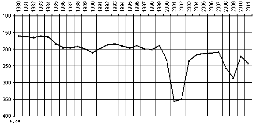
Figure 1 - the schedule of fluctuation of subsoil waters in the Republic of Karakalpakstan during 1980 - 2011
The subsoil waters sating thickness of deltoid adjournment and almost deprived of the general drain, form extensive pool with non - uniform hydro -geological conditions.
The heterogeneity is expressed in distinction of depth of subsoil waters occurrence, their mineralization, conditions of local drain and depends on food, relief and lithologic structure of rocks.
In formation of underground waters of delta, the basic role is played by the river and its inflows. Atmospheric precipitation in food of subsoil waters makes an appreciable share only in spring on the sites of superficial occurrence. The subsoil waters are spent mainly for evaporation. The underground drain has the subordinated value, being in dependence from local lithologic - geomorphological conditions. The sites of more or less well expressed local underground drain are located at the river and its inflows.
The peripheral parts of delta, near the Ustyurt in the west and in the Takhtakupyr region in the east, are usually characterized by deep (lower than 10 m) occurrence of subsoil waters; evaporation is extremely weakened.
Within the areas near the Aral Sea, characterized by abundance of often varying channels of the river, floods and lakes, subsoil waters lie down superficially (usually not more deeply than 3 m). The local underground drain in these parts of delta is considerably expressed along functioning beds (the river and its channels), playing the role of sources, food of subsoil waters. The underground drain going from beds into the depth of the shore, quickly fades (in the channels at distance of several hundred meters, and in the main channel of the river – 1 – 2 km), as in most cases it is carried out at superficial occurrence of subsoil waters which on the way of drain evaporate in the significant amount. The structure of regional balance of subsoil waters of the whole delta from Tuyamuen to the Aral Sea (without irrigation) characterizes the pool as territory of natural salt accumulation (tab. 1.)
Table 1 – The structure of regional balance of subsoil waters of the whole delta from Tuyamuen to the Aral Sea (without irrigation)
In m3/sec
|
Tides |
Expense |
||
|
Losses from the Amu Darya River (without floods) |
320 |
Underground outflow |
0 |
|
Atmospheric precipitation |
30 |
Total evaporation, increase of level of subsoil waters and return to the river |
350 |
|
Underground inflow |
0 |
||
|
Total |
350 |
Total |
350 |
The mineralization of subsoil waters in the stagnation zone is motley, the irregular distribution of salts is observed which depends basically on presence of a local underground drain [3].
The subsoil waters of near the river strip and the sites adjoining to channels have the least mineralization. Thus prevailing value have hydrocarbonate - sulphate calcium, and in immediate proximity to waterways hydrocarbonate calcium waters. In the process of increasing of the general maintenance of salts in water which is especially sharply expressed in average parts of interriverbed fallings, the maintenance of sulphates and chlorides raises, and in strong mineralized (40 - 60 gr/l) waters chlorides prevail. Among cations there sodium and magnesium prevail.
In vertical profile the mineralization of subsoil waters is also changeable. They are freshened through a local underground drain by filtrational waters of the Amu – Darya River and its inflows.
At last, saliferous, especially tertiary stocks of basement rock cause often raised mineralization of subsoil waters in the bottom part of water - bearing thicknesses. Therefore, in one cases the lowered mineralization and in others raised mineralization is observed in the depth.
By consideration of conditions of subsoil waters occurrence, it is easy to notice the feature of structure water - bearing thicknesses of deltoid adjournments. In the delta body the sandy formations of riverbed facies are widely spread. As a result of stray of the river and its inflows the riverbed facies became buried under the facies of floods and lakes presented by a layered complex of sandy loams, loams and clays, containing interlayer of fine - grained sand. The adjournments of riverbeds in the delta body have tier structure. As a result of variability of directions of a hydrographic network throughout all the history of its development of horizontal projections of ancient buried and modern riverbeds were difficult crossed.
The riverbed facies represent big interest as the sites of possible natural collectors (in case of forming in them of regional fallings of the mirror of subsoil waters with the help of dewatering from chinks). These sites are also more optimum and for localization of underground drain, though it is weak.
According to N.N.Khodzhibaeva's works [1] there are defined several groups of streams of subsoil waters in the territory of the pool .
-
A. The group of streams of subsoil waters of the left - bank of the Amu Darya River. It is settled in the western part of the pool, in the territory of the Aral Sea Basin part of the Amu - Darya delta. Its borders in the east and the southeast go along the Amu - Darya River, in the south – along the exits of basement rocks through the ledge «Nazimkhan» to the plateau «Akkelin», in the west – along the chink of the Ustyurt, in the northwest - on the fortieth hydroisohypse which is the border of the outlining stream with the stream of subsoil waters from the Sudochye Lake, in the north (symbolically) - in the area of modern forming delta. The sources of supplies of subsoil waters - filtrational losses of superficial drain and infiltration of atmospheric precipitation. In the separate sites in the old riverbeds, in adjournments of chalk and quaternary age the lenses of fresh waters with mineralization to 1 gr/l are observed. The mineralization of subsoil waters increases from the food zone to the unloading zone - from fresh to bitter - salty (from 0,5 to 50 - 60 gr/l).
-
B. The group of streams of subsoil waters of the modern Aral Sea delta. It is in the northwest part of the pool. In the west it is limited by the Amu Darya River, in the north – by the modern forming delta, in the northeast the border passes along the southwest slope of the Beltau Height, in the southeast - on the Tabakum sands. The sources of supplies of subsoil waters - filtrational waters of temporarily and constantly operating water currents and somewhat –infiltration of atmospheric precipitation. The depth of occurrence of subsoil waters fluctuates from 1 - 5 to 10 - 20 m. The mineralization changes from 0,5 (in the food zone) to 10 - 50 gr/l (in the unloading zone). In region of the group of streams the process of vertical water exchange prevails. The territory is naturally poorly drained, and in the bottom part where evaporation prevails over the drain it is undrained.
-
C. The group of streams of subsoil waters of the northern slopes of the Sultan-Uaiz-dag mountains. It is settled in the southeast part of the described pool. The sources of supplies of subsoil waters - superficial waters of the Amu – Darya River, atmospheric precipitation and water overflow of basement adjournments. The waters differ by weak mineralization (from 0,5 to 1,5 gr/l) in old riverbeds of the Amu – Darya River and raised (to 10 - 15 gr/l) in the sandy plain. In the zones of food, the subsoil waters occur on the marks of 95 - 105 m, in the unloading zones - 40 m. The direction of the stream movement is from the south to the north and the northeast.
Thanks to the complicated underground drain, and also climatic conditions of the region, the subsoil waters are spent basically for evaporation and transpiration for plants. The insignificant quantity of waters is spent for underground outflow towards the Sarykamyshsky Hollow. The outflow in the riverbeds of old rivers is a little improved. The mineralization of subsoil waters of the oasis depends on character of food and expenditure of subsoil waters and also their communication with the river. The mineralization varies from 0,5 to 5 gr/l and above.
The least mineralized waters are developed along the Daryalik and Daudan old rivers of the Amu - Darya, the most mineralized are extended mainly outside of the oasis. It says about the essential moving of waters, and consequently, and about salts in the delta under the influence of natural geological factors.
The hydrochemical profile in all the territory of the Prisarykamyshsky delta has one form: some raised value of mineralization at the mirror of subsoil waters, its reduction in the range of 5 - 15-25 m and again increase in the depth.
By the chemical compound the subsoil waters change from hydrocarbonate - sulphate to chloride -sulphatic. The parity of food of subsoil waters with evaporation has defined features of chemical compound - intensive accumulation in subsoil waters of the oasis of chlorides.
In the pool territory the distribution of subsoil waters with occurrence depth of the mirror is from 1 - 2 to 30 m. The closest occurrence of the level is observed near the Amu – Darya strip; with removal to its periphery it plunges in the deserted part of delta in the depth over 15 m.
The unloading of subsoil waters in the left - bank occurs at the expense of evaporation, transpiration and underground outflow towards the Sarykamyshsky Hollow, partial - by pinching-out in the regions of lakes of the south of Khorezm, in theAkchadarya delta – by evaporation, transpiration and partially pinching-out into the Ashykul Lake.
According to meliorative service of the Ministry of Rural and Water Management of the Republic of Uzbekistan, the areas with average and strong degree of salinization in the Republic of Karakalpakstan made in different years from 40 to 50 % of the irrigated territory, strong - from 22,7 to 64,5 thousand hectares, in Khoresm - from 12 to 39 thousand hectares. If we leave such areas without washing, it is impossible to get a crop in them. Seasonal salinization depends on depth of subsoil waters, mode and technology of watering in cotton vegetation. The salts accumulate at a lack of giving of irrigating water from above and unsatisfactory drainage of the territories by the vegetation end in the top basement layer. The salinization is the result of nonoptimal management of water resources, owing to which there are considerable losses of crop of cotton and other agricultural crops. Unsatisfactory water removal promotes stagnation of subsoil waters, but the principal reason of lifting of the subsoil waters level is the big losses of water from channels and in the fields, at watering of agricultural crops.
The average level of subsoil waters of the irrigated zone in the Republic of Karakalpakstan for 2013 is shown in tab. 2. It is visible that within meliorative systems the average annual level of subsoil waters changes from 157 to 561 sm.
Conclusions
The analysis of the available data of hydrogeologic - meliorative conditions of the irrigated zone of the Republic of Karakalpakstan on dynamics of subsoil waters in the irrigated zone has shown, that high levels of subsoil waters are observed in March and April, during the period of intensive washings, after the termination of washings there is some falling of the level.
In the irrigated area in the size of 515,3 thousand hectares the subsoil waters in the depth of 0 - 1 m occupy 7,8 thousand hectares; 1 - 1,5 m - 48,9 thousand hectares; 1,5 - 2 m - 268,6 thousand hectares; 2 - 3 m - 120,9 thousand hectares; 3 - 5 m - 66,9 thousand hectares; more than 5 m - 2,21 thousand hectares. The mineralization of subsoil waters changes as follows: 0 - 1 gr/l occupies 2,7 thousand hectares; 1 - 3 gr/l occupies 433,5 thousand hectares; 3 - 5 gr/l - 72,8 thousand hectares; 5 - 10 gr/l - 6,0 thousand hectares and more than 10 gr/l - 0,3 thousand hectares.
According to the analysis it is revealed, that from 1980 to 2011 the depth of subsoil waters fluctuated 210 - 180 sm, and in the shallow 2000 – 2001 years fell to 350 - 360 sm. For the last years the general tendency of falling of the level of subsoil waters is observed.
The least mineralization of subsoil waters is near the river strip and the sites adjoining to the channels. In the process of increasing of the general maintenance of salts in water, the maintenance of sulphates and chlorides raises, among cation there are prevailed sodium and magnesium.
The considered above laws make the theoretical basis for forecasts of the secondary salinization of soils and grounds at a long irrigation. It has been revealed, that nowadays the chloride - sulphatic type of secondary salinization prevails. At long operation of irrigating systems and washing of chloride and sulphatic salts there is a reduction of mineralization of subsoil waters, they metamorphosize in the opposite direction.
The list of the used sources:
-
1. Khodjibaev N.N. Natural streams of subsoil waters of Uzbekistan. Hydrogeology and Engineering Geology of the arid zones of the USSR, No.7, Tashkent: «Fan», 1970, p.174.
-
2. Chembarisov E.I., Khozhamuratova R. T. Applied Ecology (on the example of the Republic of Karakalpakstan), educational manual, Nukus: «Bilim», 2012, p.84.
-
3. Chembarisov E.I., Nasrulin A.B., Lesnik T.Yu., Khozhamuratova R.T. Genesis, formation and mode of superficial waters of Uzbekistan and their influence on salinization and pollution of agrolandscapes (on the example of the Amu - Darya River basin). Nukus: «Karakalpakstan», 2016, p. 187.
"Экономика и социум" №4(71) 2020
References The features of distribution of the mineralization and chemical compound of subsoil waters of the irrigated zones of the Republic of Karakalpakstan
- Khodjibaev N.N. Natural streams of subsoil waters of Uzbekistan. Hydrogeology and Engineering Geology of the arid zones of the USSR, No.7, Tashkent: "Fan", 1970, p.174.
- Chembarisov E.I., Khozhamuratova R. T. Applied Ecology (on the example of the Republic of Karakalpakstan), educational manual, Nukus: "Bilim", 2012, p.84.
- Chembarisov E.I., Nasrulin A.B., Lesnik T.Yu., Khozhamuratova R.T. Genesis, formation and mode of superficial waters of Uzbekistan and their influence on salinization and pollution of agrolandscapes (on the example of the Amu - Darya River basin). Nukus: "Karakalpakstan", 2016, p. 187.
