The Impact of Climate and Water Management on Agricultural Production in the Ganja-Dashkasan Economic Region

Author: Guliyev R.
Journal: Бюллетень науки и практики @bulletennauki
Section: Сельскохозяйственные науки
Article in issue: 10 т.11, 2025.
Free access
The Ganja-Dashkesan economic region has a predominantly semi-desert and steppe climate. The area consists of mountains and plains on the northeastern slopes of the Lesser Caucasus. These natural and geographical conditions create conditions for the development of various agricultural sectors. Global climate change and the region's water availability have a significant impact on agricultural production. Climatic factors are among the main determinants of crop diversity and productivity in the region. A sharp decline in precipitation has led to increased drought, the use of water resources dependent on transboundary rivers, and a significant reduction in phytomass. There is a close correlation between average annual precipitation dynamics and the index of physical volume of agricultural production. Irrigation systems and canals do not meet modern standards and are poorly managed, which is one of the main problems hindering agricultural development in the region.
Climate, agriculture, productivity, water resources
Short address: https://sciup.org/14133948
IDR: 14133948 | UDC: 913 | DOI: 10.33619/2414-2948/119/31
Влияние климата и управления водными ресурсами на сельскохозяйственное производство в Гянджа-Дашкесанском экономическом районе
В Гянджа-Дашкесанском экономическом районе преобладает полупустынный и степной климат. Территория состоит из гор и равнин на северо-восточных склонах Малого Кавказа. Природно-географические условия создают условия для развития различных отраслей сельского хозяйства. Глобальное изменение климата и водообеспеченность региона оказывают существенное влияние на сельскохозяйственное производство. Климатические факторы являются одними из основных факторов, определяющих разнообразие и продуктивность сельскохозяйственных культур в регионе. Резкое сокращение количества осадков привело к усилению засухи, использованию водных ресурсов, зависящих от трансграничных рек, и значительному сокращению фитомассы. Существует тесная корреляция между среднегодовой динамикой осадков и индексом физического объема сельскохозяйственной продукции. Ирригационные системы и каналы не соответствуют современным стандартам и неэффективно управляются, является одной из основных проблем, препятствующих развитию сельского хозяйства в регионе.
Text of the scientific article The Impact of Climate and Water Management on Agricultural Production in the Ganja-Dashkasan Economic Region
Бюллетень науки и практики / Bulletin of Science and Practice
UDC 913
Agriculture remains the main activity in meeting the essential needs of humanity. Observations show that a 1% increase in agricultural production worldwide is equivalent to a 0.6-
1.2% reduction in household poverty in absolute terms [9].Climate change and population growth that have occurred around the world in recent years have determined priority directions for increasing the efficiency of land and water resource use. Both processes are of particular importance for the future development of our country in terms of strategic issues affecting the development of agriculture and ensuring food security. Considering that 70% of our country's water resources are made up of transboundary rivers, and in addition, the increase in anthropogenic impacts on these rivers against the backdrop of global climate change, it is necessary to take preventive measures in this area. According to the 2023 State Statistics Committee data, the main strategic agricultural products of our country, cereals and cereal legumes, including wheat and barley, account for 57% of total area under agricultural crops, but are not sufficient to meet domestic demand [2]. These plants are widely used as a main source of carbohydrates, not only for the country's food supply, but also as raw materials in industry and the development of animal husbandry [4]. In particular, the development of livestock farming in recent years has significantly increased the production of cereals and accelerated the intensity of land use for cultivation.
The agro-climatic and soil resources, which act as natural means of production in agricultural production in the Ganja-Dashkasan economic region, create favorable conditions for the formation of highly productive crop production. The region's composition of mountains and plains creates conditions for the mutual development of crop and livestock farming in agriculture, and opens up wide opportunities for the application of various agricultural systems that preserve aboveground biomass. At the same time, the economic and geographical conditions of the region, including its location in the natural and geographical environment where the economically important rivers of the republic converge, the efficiency of access to international sea routes, and the richness of recreational and mineral resources increase the economic importance of the region and expand the possibilities for organizing a sustainable agricultural structure.
Material and method
The Ganja-Dashkashan economic region covers an area of 5.27 thousand km². The population density in the region, which accounts for 6% of the country's area and population, is 113 people per km². The Ganja-Dashkashan economic region is composed of the cities of Ganja and Naftalan, and the districts of Goranboy, Samukh, Dashkasan and Goygol.
The impact of climate on agriculture in the area was assessed in two directions. Using mathematical statistical methods, mutual regression models between dependent and fixed variables were developed. A correlative relationship was established between the dynamics of the physical volume index of agricultural production compared to previous years and the difference between the average annual amount of precipitation and temperature compared to the average multi-year. The author selected the Goranboy region, which consists of both plains and mountainous areas, to assess the temporal and spatial dynamics of the normalized vegetation difference index based on aerial photographs. Sentinel-2 aerial photographs used in the current study between 2019 and 2023 correspond to the months of April and May, when precipitation is intense, respectively. When selecting satellite images, a cloud cover of 0-3% was taken into account. The fact that cloud cover falls mainly on high mountain peaks, which are free from vegetation cover throughout the year, minimizes the error in the values of the vegetation classification degree .
The impact of climate on agriculture draws attention to the issues of efficient use of water and land resources. The decrease in precipitation is accompanied by an increase in drought, which increases the amount of water used in agriculture. Taking this into account, a correlation relationship was established between the annual acreage of agricultural crops and water supply for all economic categories of the general economic region using a mathematical statistical method.
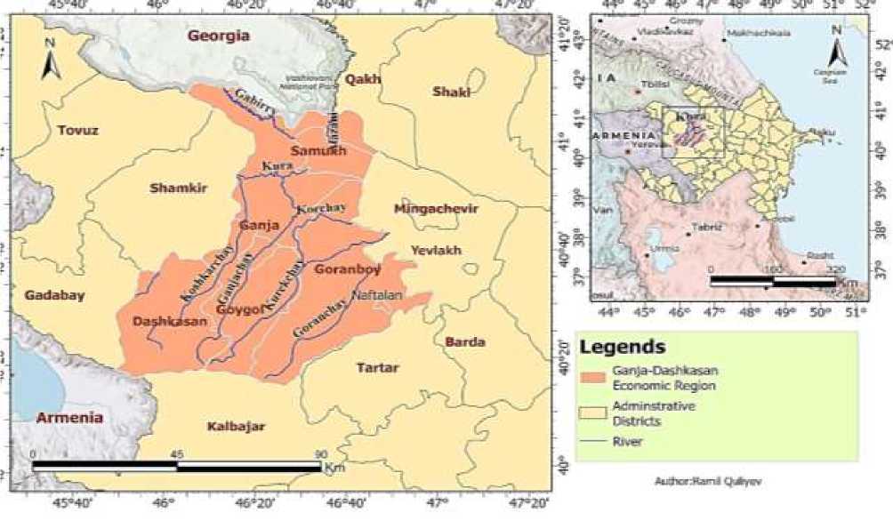
Figure.1. Study area
Results and Discussion
According to data from 2023, the share of barley and wheat in the territorial structure of agricultural crop production in irrigated fields in the Ganja-Dashkasan economic region was 49.5%. The second place is occupied by areas of fodder crops, which play a special role in the development of livestock farming, with 27%. These areas are widely used to form the feed base for livestock, such as corn for silage and green fodder, annual and perennial grasses, and root crops. The third place is occupied by row crops, including sunflower, cotton, corn, potatoes, vegetables and melons, with 12.6%. The negative characteristics of cultivating these plants include high evaporation from the soil surface, low competition with weeds, and increased soil erosion. Especially in regularly irrigated areas with slopes above 2°, there is a need to limit the production of row crops to prevent linear erosion. In areas above 3°, this process is reflected in the system of anti-erosion measures. In addition, the high demand for nutrients in these plants necessitates the application of large doses of mineral and organic fertilizers during plant cultivation. For example, up to 300 kg of potassium is used to produce almost 30 t/ha of potatoes. All these processes lead to a deterioration in the phytosanitary condition of the soil. The fourth place is occupied by perennial crops, especially grapes, dates, pomegranates, etc. (Figure 2).
The figure also shows the production structure of agriculture in all economic categories of the region for the corresponding period [2].
In recent years, the share of cereal production in the formation of the feed base for livestock has been increasing. According to data from 2023, 59% of the country's cereal production (excluding legumes and rice), including 93% of barley, 39% of wheat, and 62% of corn, is used to form the feed base for livestock [1].
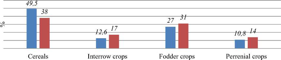
■ Territorial structure ■ Production structure
Figure 2. Territorial and production structure of crop production in the Ganja-Dashkasan economic region (2023)
From this point of view, the share of grain and fodder crop production in the production structure of agricultural crops in the study area allows us to say that the main direction of agriculture in the region is the development of livestock breeding (Figure 3).The increasing trend of barley and fodder production in the economic region in recent years relative to wheat production proves this once again.
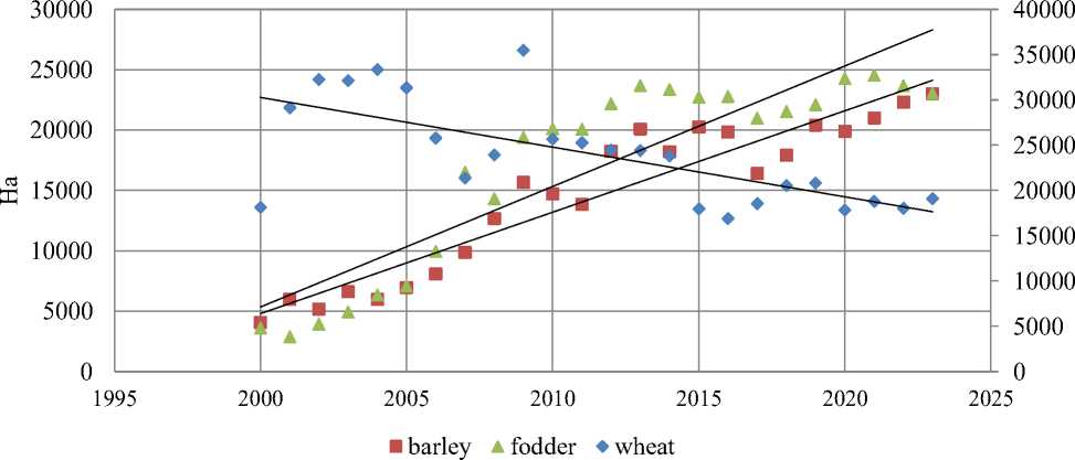
Figure 3. Spatial distrubition of barley, wheat and fodder production in the Ganja-Dashkasan economic region
Productivity indicators have always been higher in Samukh district than in Goranboy and Goygol districts. The large distribution of chestnut and alluvial meadow soils in the Samukh district of the irrigated agricultural lands of the economic region compared to Goranboy district is the primary natural factor for the high productivity of cereals, including other crops. The soils of the irrigated farmlands of the Goranboy region are mainly composed of primary gray soils, which have lower humus and nutrient reserves than gray-brown soils. In addition, the favorable access to water resources in the Samukh region creates special advantages in meeting the water needs of agricultural production. However, the lower coefficient of variation (R²) in the regression model of grain yields in Samukh district over the last 23 years compared to Goranboy district indicates high uncertainty in yields. The Goranboy region, on the other hand, has been facing serious problems in providing water to agriculture due to the long-term occupation of its water resources by Armenia.
After the new Shamkir-Samukh-Goranboy main water canal, which takes its source from the Shamkir reservoir, fully resumes its operation, it is planned to improve the irrigation water supply of 94 thousand hectares in the region, including 27 thousand hectares of newly irrigated lands.
The coefficient of variation of productivity in the Goygol region also received a lower value (Figure 4, 5).The Goygol region is composed of mostly mountainous areas, starting from the foothills of the northern and northeastern slopes of the Lesser Caucasus Mountains. In these areas, the increase in the inclination and fragmentation of the slopes creates conditions for the intensification of the erosion process and the decrease in soil productivity [3]. The decrease in the number of sunny hours and the increase in precipitation in the foothills create conditions for the extension of the vegetation period. Insufficient irrigation systems or limited water sources negatively affect productivity. Since the minimum altitude in the Dashkasan region starts at 750 m, the productivity of cereal crops grown mainly in rainfed conditions is low and not sustainable. The average productivity here is 16-18 centners/ha.
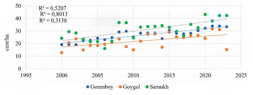
Figure 4. Wheat productivity in districts of the Ganja-Dashkasan economic region
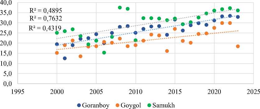
Figure 5. Barley productivity in districts of the Ganja-Dashkasan economic region
The favorable natural and climatic conditions for the production of winter wheat and barley crops in our republic, including in the region, are explained by the optimal range of precipitation and temperature during the autumn sowing period, which affects its future productivity. Maximum rainfall in the region during the active vegetation period of autumn grain crops is effective in
Бюллетень науки и практики / Bulletin of Science and Practice Т. 11. №10 2025 meeting irrigation needs. Current research shows that increasing temperatures, changing precipitation patterns, and increasing extreme weather events are significantly disrupting the phenological stages of wheat, reducing both crop stability and grain quality [11]. The impact of climate on agriculture varies depending on the region and crop. The impact of different climate scenarios on crop yields has been assessed in many studies. The 4th and 5th Assessment Reports of the Intergovernmental Panel on Climate Change (IPCC) predict that crop yields will increase from mid-latitudes to high latitudes under conditions of 1-3°C warming [12]. Without CO2 fertilization, effective adaptation, and genetic improvement, each degree Celsius increase in global average temperature reduces, on average, global wheat yields by 6.0%, rice yields by 3.2%, corn yields by 7.4%, and soybean yields by 3.1% [7]. High concentrations of carbon dioxide in the atmosphere increase photosynthesis and biomass in plants. Higher concentrations reduce transpiration, preventing water loss [10].
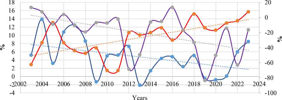
According to data from the meteorological station in Ganja, it is clear that the region's temperature and precipitation indicators have changed significantly. According to the data obtained, the average annual precipitation in the region over the last 22 years has decreased by 19% from the multi-year average, and the temperature has increased by 1.4°C. Rising temperatures can shorten the growing season, which can lead to reduced yields in plant species that are not adapted to the climate. On the other hand, provided there are no problems with water supply in the area, increasing temperatures shorten the growing season and increase productivity, especially in rainfed cultivation. At the same time, it allows the formation of natural conditions for harvesting twice a year in some areas [6]. All these processes have led to a decrease in natural water resources, an increase in the demand for irrigation in agriculture, and a decrease in the productivity of aboveground biomass in natural and irrigated pasture areas.
Based on data obtained from the Sentinel 2 satellite, it was determined that the normalized vegetation cover index of the Goranboy region has a correlative relationship with the precipitation in the area. It can be observed that the degree and area of land cover with vegetation increase in years when precipitation increases (Figure 6).
0,1-0 0,001-0,2 0,2-0,4 0,4-0,6
0,6-0,8 precipitation
Figure 6. Normalized vegetation index values for Goranboy district
Figure 7 shows a correlation between the difference between the average annual temperature and precipitation indicators of the study area from the average multi-year average and the physical volume index of agricultural production (livestock and crop production) compared to previous years. From the analysis of the graph, it is clear that the coefficient of variation of the mutual development trend of precipitation and agricultural production reflects close numbers. In years with high precipitation, agricultural production indicators were high. The observation of distortion in some years can be explained by the effect of the amount of precipitation falling in the autumn months on the production indicators of the following year.
Physical volume index of agricultural production in percent
Difference of average annual temperature from the multi-year average
Difference of average annual precipitation from the multi-year average
Figure.7. Relative development dynamics of precipitation, temperature and agricultural production
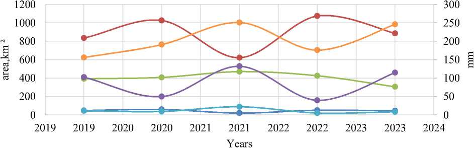
Along with global climate change, water management is one of the factors affecting the production of agricultural crops. The area of actually irrigated farmland in the region, including backyard plots, covers 107,242 ha, including 61,740 ha in Goranboy district, 30,000 ha in Samukh, 12,626 ha in Goygol, 2,584 ha in Dashkasan and Ganja city, and 292 ha in Naftalan ; ; ; . In addition, irrigation of another 21,500 ha of arable land, including 4,000 ha of pasture land used for sowing, 10,500 ha of state fund lands, and 7,000 ha of municipal lands, is also being carried out in Goranboy, which actually means that 83,240 ha of arable land in the region is being irrigated. A correlative relationship has been established between the dynamics of the expansion of the region's total agricultural crop areas and irrigation and agricultural water supply (Figure 8). Observations show that although there is a positive correlation between these two indicators between 2009 and 2023, the low coefficient of variation is an indicator of inefficient use of water resources. Thus, in 2009, 349 million m³ of water was used to irrigate 88.2 thousand ha of land, while in 2010, 347 million m³ of water was used to irrigate 79.2 thousand ha of land. Although the percentage of water loss in the use of water resources in recent years has decreased by 10% compared to 2017 and amounted to 27% in 2023, this indicator is a significant indicator for a country where 70% of its water resources depend on transboundary rivers. However, in agriculture, where 80-90% of irrigation is carried out extensively, the percentage of these losses increases even more. Studies show that climate change will further increase water scarcity in arid areas in the future. While 40% of global arable land suffers from water scarcity today, water scarcity in those areas is expected to increase by 83-84% in the future [8].
The main solutions to this problem in our country depend on the organization of melioration design in accordance with modern standards in agricultural water management, the improvement of irrigation systems, and the degree of application of drought-resistant plant species in agriculture. In addition, periodic repair and restoration work in canal networks ensures the activity of water flow, significantly reducing water infiltration into the soil, evaporation, and transpiration [9]. Naturally, all these processes, including climate change, lead to a shortage of water resources in arid areas, a decrease in agricultural production and productivity.
E 400 д о
Е
y = 0,0137x - 673,62 R² = 0,2228
• 347
• 380
• 503
• 613603 • 603
•_.530
• 578 • 596
• 419451
• 451
• 349
82000 84000 86000 88000 90000
Cultivated area, ha
Figure.8. Water consumption in the production of agricultural crops in the Ganja-Dashkasan economic region
Conclusion
-
1. Inefficient use of water resources in agricultural production and irrigation has been identified in the region. Reorganization of irrigation canal infrastructure in the region and increasing investments in the application of intensive agricultural systems are considered priority areas.
-
2. Positive correlations were found between the development trend of precipitation and the physical volume index of agricultural production, while negative correlations were found for temperature.
-
3. Based on the Sentinel 2 database obtained through remote sensing between 2019 and 2023 in the Goranboy district, satellite images were decoded and it was determined that the vegetation cover and density of the area changed depending on precipitation.
