The review of existing technologies of creation ortophotoplans on linear objects

Free access
The review of existing methods and technologies of creation of orthophotomaps on linear objects taking into account use of classical as well as modern technologies of shooting and data processing is provided in this work. The technology of creation of orthophotomaps consists of the following stages: creation of the project and input of basic data; realization of internal orientation of pictures; measurements of coordinates of binding points; measurements of coordinates of points of planned and high-rise preparation; calculation and creation of photogrammetric model; creation or qualifier import; drawing areas on pictures in which the orthophototransformation; creation of Digital Elevation Model; creation of orthophotomaps.
Ortophotoplan, linear object, coordinates, centers of photography, photogrammetry
Short address: https://sciup.org/147124543
IDR: 147124543 | UDC: 528.7
Text of the scientific article The review of existing technologies of creation ortophotoplans on linear objects
In recent years because of the broad introduction of digital technologies in cartographical production, planned and cartographical basis for creation of topographical, land and cadastral and other cartographical documents are orthophotomaps.
Specialists of scientific and production firm Talka-TVD developed technology of creation of orthophotomaps at the TALKA digital photogrammetric stations (DFS). This technology provides realization of several stages of works in parallel that allows to create production in a short time and to use available capacities more flexibly.
Before photogrammetric processing aerial photographs are being scanned on the photogrammetric scanner and transferred to a digital form. In a digital form aerial photographs are not subject to «ageing», they aren't deformed because of the difference of temperatures, not jarred on, don't lose contrast, they can't be scratched. Copying of digital aerial photographs can be executed at any time.
The scanned pictures are being processed on Digital Photogrammetric Station. At the first stage cap installation is created which is used for scheduling on carrying out planned and high-rise preparation, and also used by field crews in case it is necessary to carry out a field interpretation urgently.
After creation of cap installation, or in parallel, the project of a planned and high-rise binding of pictures (XYZ TRAINING) is being created on Digital Photogrammetric Station. The XYZ TRAINING project includes cap installation or the photo scheme with noted points of XYZ TRAINING, an aerial photograph with the point noted on it and the increased fragment of a picture where already the location of a projected point in more detail is visible.
After project creation or right after scanning a photogrammetric condensation and creation of photogrammetric model in which DEM can be created is started.
After realization of internal orientation, measurements of coordinates of the binding points which are necessary for creation of a phototriangulable network and creation of free photogrammetric model are made. After measurement of coordinates of binding points and creation of photogrammetric model creation of DEM is started. Thus, creation of DEM is carried out in free photogrammetric system of coordinates. After carrying out external orientation of photogrammetric model i.e. when points of planned and high-rise preparation were entered into the project, DEM is recalculated in system of coordinates of reference points. If by then as external orientation of photogrammetric model was executed, DEM was already constructed on all objects, it is possible to start creation of orthophotomaps.
Application of the presented technology allows reducing terms of production of orthophotomaps and digital cards in two and more times in comparison with technology when separate technological processes can't be carried out in parallel.
The use for air photography of modern aerial cameras with a big format of a shot allows reducing costs of processing of linear objects.
As a rule, for obtaining orthophotomaps of scale 1:2000 scale 1:10 000 air photography - 1:12 000 LMK cameras (Karl Zeiss, Germany), by RC-30 (Leica Geosystems, Switzerland) either AFATEKA-2123 (Russia), or scale 1:8 000 the AFA chamber (Russia) are carried out. The quantity of pictures at application of modern aerial cameras is reduced by 1,6-1,9 times. Besides modern aerial cameras at air photography has the big width of a removed strip that allows carrying out smaller quantity of routes. Considerable reduction of quantity of pictures and routes leads to reduction of time and material inputs on a photogrammetric condensation, and also to reduction of quantity of points of planned and high-rise preparation, as shown on image below.
Figure 1 – Example of picture prepared using modern cameras
If at air photography the GPS-equipment, allowing receiving coordinates of the centers of photography is aboard installed, when mapping linear objects it is possible to reduce quantity of points of planned and high-rise preparation at 5-10 time. In recent years in Russia RC-30 aero photosystems (Leica Geosystems, Switzerland) have appeared. They allow not only to receive high-quality pictures of format of 230*230 mm at the expense of application of the lenses having high resolution and a small distortion, but also the coordinates of the centers of photography of each picture.
For this purpose aboard along with aero photosystem (AFS) the GPS receiver is being installed which with discretization in 1 second determines geocentric coordinates of location of the plane (to be exact, GPS receiver antennas) in WGS-84 system and operates work of a lock of AFS. The coordinates relating by the time of opening of a lock, are fixed as COORDINATES OF THE CENTERS OF PHOTOGRAPHING.
For ensuring high precision of COORDINATES OF THE CENTERS OF PHOTOGRAPHING the so-called differential method is used. Its essence is that on the earth around air photography performance, on a point with known coordinates with high precision, the second GPS receiver is installed. Post-processing of results of measurement of onboard and land GPS receivers allows receiving with an accuracy of several decimeters COORDINATES OF THE CENTERS OF PHOTOGRAPHING in the set system of coordinates. And this accuracy depends on distance between onboard and basic GPS receivers. The less it is, the higher COORDINATES OF THE CENTERS OF PHOTOGRAPHING accuracy is.
In the beginning COORDINATES OF THE CENTERS OF PHOTOGRAPHING were used as addition to reference points. I.e. equalizing was carried out on reference points and
COORDINATES OF THE CENTERS OF PHOTOGRAPHING. Control of results of equalizing was carried out on independent control points. Control points are reference points which were measured on pictures along with binding and basic, but their coordinates weren't used when equalizing a photometric network.
Equalizing with use of various basic data according to three real projects which processing was conducted in the production purposes in the photogrammetric TALKA program was executed. In all projects scale 1 picture were used: 20 000, received by RC-30 aero photosystem with focal length f=153мм scanned on the photogrammetric Delta scanner with pixel of 16 microns.
Results of equalizing on three projects are presented in Table 1 for five options, estimated on control points and the calculated denominators of scales of cards and relief originals which can be created by these results.
Table 1 - Results of equalizing with use of COORDINATES OF THE CENTERS OF PHOTOGRAPHING allow creating orthophotomaps according to AFS materials in scale 1:20 000 and relief originals in scales 1: 5 000 and smaller
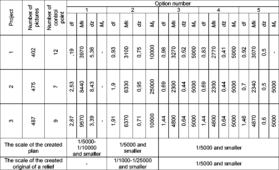
Equalizing of a network of a phototriangulation with use of COORDINATES OF THE CENTERS OF PHOTOGRAPHING yields more exact results (both in the plan, and on height), than equalizing only on reference points.
The reference points, which coordinates are received by geodetic methods, can be used for control of accuracy of the created orthophotomaps and relief originals. But in this case their number can be reduced.
Control of results of equalizing can be exercised on some COORDINATES OF THE CENTERS OF PHOTOGRAPHING which aren't included in equalizing. For definition of number of such COORDINATES OF THE CENTERS OF PHOTOGRAPHING and their location in the block additional pilot studies are required.
In article [9] it was shown that at the vulgar air photography including a large number of aerial photographs in general and routes in particular, the use of COORDINATES OF THE CENTERS OF PHOTOGRAPHING is very effective. But recently there was a need to receive an orthophotoimage and cards along linear objects (iron and highways, power lines, pipelines, etc.). When using a traditional method it is necessary to have reference points at the edges of a linear route approximately through five bases. So, for example, for receiving the digital orthophotoimage corresponding on accuracy up to scale of 1:10 000, on the materials AFS of linear object 1 000 km long received in scale 1: 40 000, it is required about 100 landmarks.
Considering that the large linear object, as a rule, passes most often through the low-rendered habitable and almost impassable sites of the district, it is rather difficult to execute a planned and high-rise binding in these parts. Therefore, in this case time and cost of a planned and high-rise binding increase.
When performing AFS to receive COORDINATES OF THE CENTERS OF PHOTOGRAPHING a differential method is applied. Its essence was described above.
Further in article [9] the experiment is described. Its purpose was definition of possibility of use of the photography centers coordinates at air photography of linear object for orthophotomaps creation.
As basic data 3 routes with 34 pictures in each were taken. Air photography was executed by RC-30 aero photosystem, with focal length of 152,850 mm in scale of 1: 20 000.
Longitudinal overlapping made 60%, cross 30%. COORDINATES OF THE CENTERS OF PHOTOGRAPHING were received with an accuracy of 0,5 m in local system of coordinates. Experiment included: scanning of aero photonegatives; phototriangulation; comparison of results; scanning of aero photonegatives was made with use of the photogrammetric Delta scanner (NPP Geosystem, Vinnitsa, Ukraine) with pixel of scanning of 16 microns.
The phototriangulation was made with usage of DIGITAL PHOTOGRAMMETRIC STATION «TALKA».
Results of experiment showed that COORDINATES OF THE CENTERS OF PHOTOGRAPHING usage on two next routes provides the accuracy of a planned and high-rise binding, sufficient for creation of orthophotomaps in scale 1: 5 000 and smaller. And with increase in number of parallel routes accuracy, practically, doesn't increase.
From here it is possible to draw a conclusion that if the accuracy of creation of orthophotomaps doesn't depend on quantity of routes, is quite equal to use the coordinates of the centers of photography for creation of orthophotomaps on linear objects, carrying out shooting in two routes. As when using COORDINATES OF THE CENTERS OF PHOTOGRAPHING in two parallel routes the so-called «the hinged effect» is excluded.
The authors [9] note that use of COORDINATES OF THE CENTERS OF PHOTOGRAPHING will allow excluding performance of field planned and high-rise preparation.
But, in spite of the fact that such researches are conducted, it is obviously not enough of them, and the most important is that as a result of these researches single results without additional check are received. It is possible to check theoretical calculations and make some amendments to them as it was made by the author of work [4] who considered the calculations provided in the article «The Equations of Amendments at Construction and Equalizing of an Analytical Phototriangulation with GPS Use» of authors Yarmolenko A.S. and S. N. Kandybo, in a number of scientific and technical works the final results of research are given without description of algorithm of equalizing.
There is a number of shortcomings in work [12]. This article can be divided into two parts. In the first part the need of coordination of two systems (WGS-84 and SK-42) is indicated. Methods of such coordination were repeatedly discussed in scientific and technical literature of a geodetic profile. Finally, the task is reduced to transformation of coordinates of points of one system into another. The authors use the three-dimensional transformation which parameters are on three points which have been set in both systems. During transformation applying known formulas, the transformation of flat rectangular coordinates and normal heights of points into geodetic and geocentric coordinates and back is carried out.
In the second part the authors of article [12] refer to work [3]. But thus they ignore its main idea - photogrammetric constructions in an analytical and digital photogrammetry. Furthermore in a phototriangulation they must be carried out not in system of coordinates of a geodetic projection, but in some spatial system of coordinates. For these purposes it is best of all to enter special system, having connected its beginning with the block gravity center, and to draw axis of coordinates parallel to projection axes respectively.
Also it should be noted that the authors forget to mention the systematic distortions peculiar to satellite measurements, as well as any other types of geodetic works.
The author of article [4] notes that the accumulated experience unambiguously testifies that it is impossible to create a good phototriangulable network, neglecting systematic errors of the measured sizes. Also I. T. Antipov calls into question Yarmolenko A.S.’s and S. N. Kandybo’s treatment of weights of data of GPS - that is quite reasonable. Yarmolenko A.S. and S. N. Kandybo determine weight in a separation from quality and the measuring accuracy of pictures that is essentially wrong. Where diverse sizes are exposed to compatible equalizing, weight has to reflect their comparative accuracy. Therefore, at determination of weight of satellite data it is necessary to consider an average quadratic error of measurement of coordinates of points in a picture and the scale of pictures.
Also it is necessary to remember the weight of the equations of amendments of the collinearity conditions which were written down for reference points.
The number of the works done in Russia concerning phototriangulation accuracy is insignificant, but their analysis shows certain results contradictoriness.
In the work [7] the authors claim that in block networks of a phototriangulation the accuracy of accumulation remains identical at different routes miles, while in work [5] it obviously isn't identical.
In work [7] it is claimed that there is no direct dependence of accuracy of accumulation on the accuracy of determination of coordinates of design centers. Also influence of correlation of satellite measurements on phototriangulation accuracy isn't established.
In work [5] reduction of number of reference points in case of determination of coordinates of the centers of design is unreasonable.
References The review of existing technologies of creation ortophotoplans on linear objects
- Alcinov A.I., Kekelidze V.B. Technology mapping of linear objects//Geoprofi. -2004. -№5. -pp. 3-5
- Alcinov A.I., Kekelidze V.B. Technology for creating orthophotos in DPS «TALKA»//Geoprofi. -2004. -№6. -pp. 19-21
- Antipov I.T., Timofeeva O.A. Accounting for the influence of the curvature of the Earth and geodetic projection at work on analytical and digital photogrammetric devices//Geodesy and cartography. -1998. -№2. -pp. 31-37
- Antipov I.T. Spatial phototriangulation using the coordinates of the centers of photography//Geodesy and cartography. -2004. -№8. -pp. 21-30
- Belikov P.A., Kadyshevskii S.A., Kislov V.S., Khmelevskiy S.I. Test ground for assessing the accuracy CCP using GPS equipment//Geodesy and cartography. -1997. -№4. -pp. 23-30
- Kadyshevskii S.A., Khmelevskiy S.I. About the accuracy of the network building the triangulation on the coordinates of the centers of photographing obtained using GPS methods//Geodesy and cartography. -1997. -№8. -pp. 30-34
- Kadyshevskii S.A., Khmelevskiy S.I. On the required accuracy of definition of coordinates of center of projection//Geodesy and cartography. -2000. -№8. -pp. 28-33
- Kekelidze V.B., Melnikov A.V., Myshlyaev V.A., Tyukavkin D.V. Using the coordinates of the centers of photographing during the processing of aerial survey//Geodesy and cartography. -2003. -№5. -pp. 31-35
- Melnikov A.V., Myshlyaev V.A. Processing aerofilms in digital technologies for creation of cadastral maps//Geodesy and cartography. -2003. -№2. -pp. 34-38
- Myshlyaev V.A., Kekelidze V.B., Tyukavkin D.V. Using the coordinates of the centers of photography in aerial photography linear objects//Geodesy and cartography. -2006. -№3. -pp. 34-37
- Yarmolenko A.S., Kandybo S.N. Equations of amendments in the construction and adjustment analytical phototriangulation using GPS//Geodesy and cartography. -1999. -№7. -pp. 21-24
- Yarmolenko A.S., Sosina E.Y. Establishment of precision, single-path spatial mapping using the coordinates of the centers of projection//Geodesy and cartography. -2007. -№1. -pp. 46-51
