Virtual ecological routes and pathesin the natural-cultural geo sustems and ecological behaviour

Author: Korbut V.V., Tulskaya N.I., Zekina M.V.
Journal: Arctic and North @arctic-and-north
Section: Ecology
Article in issue: 14, 2014.
Free access
The innovate conception of virtual ecological paths as a foremost edition for ecotourism and attendance’s preparation in specially protected natural sites was suggested. It’s has a vital importance for remote and sensible ecosystems. The virtual ecological paths will be able to important stage of environmentalization of awareness on the base of modern technologies of elicitation, data processing and storage of information.
Ecotourism, ecological path, environmental education, ecotone, digital technology, littoral, toponymy
Short address: https://sciup.org/148319873
IDR: 148319873 | UDC: 502.11+338.48‐6:502/504(470.21)
Text of the scientific article Virtual ecological routes and pathesin the natural-cultural geo sustems and ecological behaviour
Global environmental problems increasingly affect the interests of all mankind and every individual. In the report "Principles of state policy in the field of environmental development of the Russian Federation for the period till 2030"1 defined strategy and main challenges in the field of the environmental protection, implementation arrangements in the modernization of the economy, innovative development tools. Ensuring sustainable, green growth economy is impossi--‐ ble without the conservation of biological diversity and the natural resources needed to imple--‐ ment the human right to a healthy environment.
Currently is intensified the formation of environmentally responsible attitudes and envi--‐ ronmental culture through the development of environmental education and training [1, 2002], especially in the form of eco--‐tourism. Direct contact with the natural objects for cognitive purpos--‐ es is best carried out in the territory of the various protected areas as ecological trails and paths [2, 2011, 3, 2012]. However, the intensive use of natural and cultural sites for environmental edu--‐ cation and awareness is not always possible (seasonality, weather, etc.), and occurs when tours increased human pressure on their Geosystems leads to various disorders, weakening and even irreversible destruction of their biological and cultural components [1, 2002 2, 2011 3, 2012]. To reduce or mitigate these impacts, as well as the intensification and increasing creativity of ecologi--‐ cal thinking, we propose to use virtual ecological trails2.
The aim is to develop the concept of virtual ecological trails and paths as the initial stage of acquaintance complex natural and cultural objects, phenomena and processes necessary for the formation of ecological culture.
Materials and methodology
Collection of the materials held in the intertidal zone of the White Sea in the innermost part of the Kandalaksha Bay (Kandalakshsky State Nature Reserve, sightseeing and tourist area, cordon Luvenga, 67o06--‐N, 32o42--‐E).
Littoral of Kandalaksh gubi vary in appearance, width and structure --‐ rock, smooth glacier "muttons foreheads", ridge ("spit") boulders, gravel or sand and silt beaches. Drying zone bounda--‐ ry encloses boulders, arising from the interaction fast ice and tidal currents, seaward --‐ tidal beach or hillside. In the innermost part of the gybi most of the coastal littoral meadows busy turning into sand and silt beaches to hundreds of meters wide.
Littoral ("coast, coastal") – is a natural ecotone, the transition zone between the mainland and the sea, continuously changes the appearance. In ecotones specific spaces between communi--‐ ties and systems "actively proceed geographical and ecological processes" [6, 1197], which makes them especially difficult to understand, but very interesting for the purposes of the environmental education, training and formation of ecological culture.
White sea waters, are depending on the phases of the moon rises twice a day to 2 - 3 m and drops to 0 m Length tide on 1,5 - 2,0 hours behind at low tide. In Kandalaksha lips are many forested islands and islets, small treeless "Ludy" rocky shoals corgi, pour water in the tide, and the huge stones baklyshi.
Main place of work – is Luvengskaya Guba in the outfall Lower Luvenga creating significant seawater desalination. Guba is fenced off from the sea group of small islands. The water level in the tidal cycle in the work place (sightseeing and tourist area) from 0.0 to 2.8 m, while exposed to 0,5 - 1km 2 littoral [4, 2012]. White Sea, River delta. Luvengi, island archipelago Kandalakshsky shore create a picturesque landscape, particularly valuable in terms of recreation and ecotourism.
Human activities in the surrounding area for several centuries has created a natural and cultural landscapes --‐ "ecological footprint " of a person. Already in the XVI century, mentioned semuzhya tonya and saltworks Luvengi absorb huge amounts of fuel and in XVIII - XX centuries in the surrounding taiga conducted mass industrial logging. Forest and drove on many islands, using them as pasture. In 1960 - 1970. Luvenga village was built for 2000 people, a dairy farm on 1,5 - 2 thousand cows, set up an appropriate agricultural infrastructure --‐ field, storage, roads, etc.
Ecological path (real and virtual) is installed in the mouth of the river and covers the sur--‐ face of the intertidal to subtidal zone of coastal meadows. As prerequisites virtual ecotrail we con--‐ sider it necessary to use historical information, Annals of Nature Reserve, survey data of the local population.
Demonstrated materials – are digital photos (author V.V. Korbut ) cordon around Luvenga observations during 2004 - 2013 performed under different conditions (weather, time of day, tid--‐ al stage , etc.) and photo mode, including in macro mode. Such a form of presentation --‐ discrete --‐ allows the tourists to focus on a detailed examination of the complex biological objects and im--‐ merse yourself in their world. On a series of images shows the most common natural objects and processes in place to form a sequence of images outside of the timeline.
The main objects of the show: changing the face of the littoral depending on the phase of the tide, climate seasonality and different weather; biological objects --‐ plants, marine inverte--‐ brates and vertebrates (worms, mollusks, crustaceans, fish, birds).
For disclosure of human activity in the subarctic conditions as an important component of the development and demonstration in the virtual ecological path we use the terms --‐ words and phrases of the local dialects and sub--‐dialects (Lappish, Karelian and Pomeranian) identifying his--‐ torically designations of the natural objects and/or processes [5, 2005]. Some of them joined the international scientific terminology.
All material is grouped in the demo database, which consists of several units, including units that contain digital photographs of natural phenomena and objects, their text support (Table 1). Block --‐ a set of the modules, a common theme; module – is the basic unit of storage of the digi--‐ tal photos and text materials needed to build virtual ecotrail. Number of modules in the blocks varies depending on the subject created trails. For exampl, the unit "geomorphological features", consisting of the modules "microrelief", "Coastal Processes", "Forms of the surrounding terrain" etc. The proposed scheme is not absolutely rigid and allows you to create new topics, supple--‐ mented by new units and modules. Such an approach to create a mobile system for forming virtu--‐ al modular ecotrail.
Such a structure (Table 1) allows to increase or decrease the "route" depending on the tasks demonstrations, "compress" the time of the route, various processes, "stop" object / process for its detailed consideration of the interpretation or methods of scientific analysis and artistic ap--‐ preciation.
Table 1
Compositions blocks and modules for the creation of virtual ecological trails
|
Blocks |
Mod--‐ ules |
The content of the module |
The level of the module |
|
|
Litoral |
A |
general geographic information |
A1 |
Maps, shemes, satellite imagery |
|
B |
Tidal processes |
B1 |
Kuipoga |
|
|
В2 |
Verhovodie |
|||
|
C |
hypsometric levels of littoral |
C1 |
Litoralnaya Luga |
|
|
С2 |
Sublitoral |
|||
|
С3 |
Supralitoral |
|||
|
D |
Description (appearance) littoral |
D1 |
Micro relief |
|
|
D2 |
Mezo relief |
|||
|
E |
Dynamism appearance of littoral |
E1 |
Bath and streams littoral |
|
|
E2 |
Shallows |
|||
|
E3 |
Other elements |
|||
|
Flora and Fauna |
F |
Plants |
F1 |
Weed |
|
F2 |
Lichens |
|||
|
F3 |
Vascular plants |
|||
|
Animals |
F4 |
Invertebrates |
||
|
F5 |
Vertebrates |
|||
|
Cultural and historical as--‐ pects |
J |
Cultural landscapes and nature |
J1 |
Historical aspects |
|
J2 |
Natural aspects |
|||
|
J3 |
Toponimika |
|||
|
J4 |
Selitba |
As an example, a fragment of a virtual ecological path "Vegetation and animal population of the intertidal zone." Beginning of the story as part of a demonstration trails associated with the geomorphological, landscape and cultural features needed to start forming the image of the area. Highlighted text corresponds with the oral stories of guides accompanying display of visual mate--‐ rial.
As the "promotion" to the virtual path pay attention to different levels of tourists ecologi--‐ cal pyramid littoral communities, starting with kelp fucoids growing on rocks and stones at the bottom of the intertidal zone. Leaves, roots and stems of algae are not, they replace the thallus or thallus. Pomors named their tour, and it covered stones --‐ turnitsami. These plants need a marine or brackish water, the sun and the substrate for the attachment.
In the uppermost part of the intertidal zone we find higher vascular plants that can with--‐ stand regular wetting and drying, long--‐lasting, increased salinity . This " kasha" small herb with powerful roots, rhizomes or bulbs with a reserve of nutrients. One of them --‐ Solonchakovaya or sea aster Aster tripolium L. ( Fig. 1) --‐ is interesting because pollination occurs under water (pollen floats in her column) and in the air, insects. Sea plantain Plantago maritima L. --‐ perennial with slender stems and narrow leaves collected in the rosette, inflorescence --‐ spike up to 50 cm.
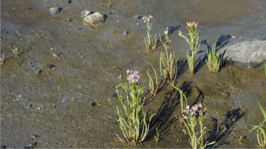
Pic. 1. (Aster tripolium)
One of the many intertidal animals – are marine polychaete worm lobworm (Arenicola ma--‐ rina L.), living at a depth of up to 30 cm in sandy--‐muddy bottoms and forming settlements of dif--‐ ferent sizes (Fig. 2). When the worm ingests soil on the surface of shallow recess occurs --‐ funnel;
ejected from the intestine for long strings of sand with mucus to form near the sandy mounds--‐ cones correct form.
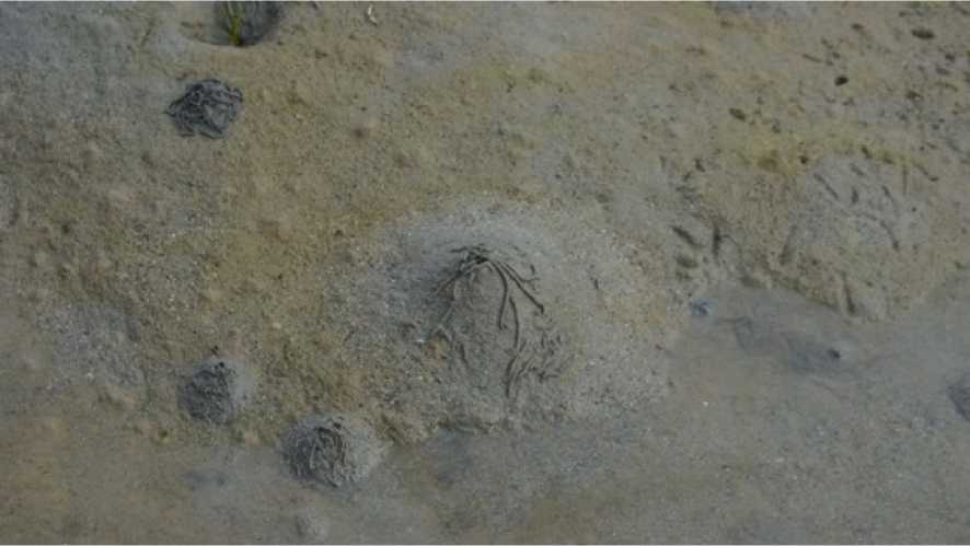
Pic. 2. Arenicola marina
Among the numerous shellfish note, first of all, edible mussel (Mytilus edulis L.), marine bi--‐ valve filter feeders. Form clusters of several shells of mussel beds to huge underwater shallows. Clam length of 5 cm - 6 skips to 3 liters of water per hour, eating small objects floating in the wa--‐ ter.
Iron in the foot of the mussel byssus thread highlights strong holding a clam on the sub--‐ strate even when severe storms. Young mussels no longer than 2 cm - 1 good move, sedentary adults. Lay up to 5 - 25 million eggs, larva swims in the water column, reaching a length of 0,2 -0,3 mm is deposited on the substrate. Along the shores of Europe for the first year they grow to 3 - 4 cm in the cold White Sea to 0.5. They live up to 13 - 14 years.
Among the White Sea mollusks have actively crawling and burrowing into the ground to a depth of littoral input and output siphons, single or double flexible and mobile handsets.
Maqam (Macoma balthica) – is small shellfish clams up to 2 cm, round shape. In kuypogu actively crawling along the ground, sucking food through a siphon input (like a vacuum cleaner). When bolshevode burrow into soft silty--‐sandy soils, breathe and eat through a siphon.
Mia (Mya arenaria), shell length 10 cm, the inhabitants of the shoals at a depth of 10 - 50 cm. Siphon --‐ is two fused tube length up to 50 cm, covered with a dense shell holes on the edge of growths protrude above the ground on 5 - 15 mm. Live up to 15 - 18 years.
Sinks of the dead mollusks lie on the surface of the intertidal zone, birds eat them, filling the deficit of minerals, especially calcium and magnesium [4, 2012].
Crustaceans are common in the intertidal zone (Crustaceae), especially noticeable sessile crustaceans --‐ barnacles (Balanus), barnacles barnacles of the suborder (Balanomorpha). These fil--‐ ter--‐ fouling attached to rocks, shells of mollusks, underwater structures, tree roots, bottoms of ships, forming colonies. Their larvae swim freely, adults lie on your back in a limestone house of six plates ( four mobils). Between the plates exposed legs, crayfish rhythmically flapping them driving into the house water with food particles. Done at the waters they are tightly closed shutters. In the cold waters of the White Sea barnacles live up to 7 years.
In the high tide and low tide in the water and on the wet substrate seen moving sandhop--‐ pers of Sem. Gammaridae. In kuypogu they are hiding in the rocks of the littoral and fucoidan at bolshovóde swim in the water, eating detritus and preying on small animals.
All animals and their larvae are the part of the coastal marine plankton food webs consti--‐ tute littoral included in diets of many species of the marine invertebrates (starfish, crabs, clams) and vertebrate animals, fish, birds and mammals.
Even kuypogu intertidal fish can be found on desalinated littoral streams and puddles. Most often visible flocks moving fingerlings of different species of sticklebacks Sem. Gasterosteidae, Kolyushkoobraznye. These fish do not have scales, and some sharp elongated spines alone close to the body, and with the threat of moving, menacingly up and sticking out the sides. Common in the intertidal zone during the "Done waters" flounder, Sem. Pleuronectidae, flatfish.
Trophic resources littoral attract vertebrates able to effectively use ecotones [6, 1997, 4, 2012], such as the oystercatcher (Haematopus ostralegus), bluish (Larus canus) and silver (Larus argentatus) gulls.
Beak and legs of Oystercatcher are long, red, black and white body. At high water bird sit--‐ ting on the corgi, baklyshah groups of 2 - 5 individuals, as care waters move in the shallows. In kuypogu eat mussels on banks, drainage areas gather food from the surface or probed thickness of soil, plunging beak 5 - 15 cm and groping sink.
Seagulls in bolshovóde are sitting on ludam and baklysham, cleaned or sleep for 3 - 4 hours before kuypogi begin to feed on intertidal beaches on corgi and turnitsam.
In the natural and cultural landscapes of the Kola Subarctic over 100 years ago and pene--‐ trated hoodie (Corvus corone cornix); kind incurred as ecotones steppe zones of Eurasia, now mastered the White Sea. In bolshovóde they fly ashore in kuypogu actively feeding on intertidal areas with dry, moving on turnitsam, corgi, creeks and shallows, collecting dead or careless marine animals, hunting sandhoppers and fish.
Discussion
One of the contradictions of ecotourism is to connect the show "interesting" objects and their degradation, and even loss, during recreational use [2, 2011, 3, 2012]. Reducing the conflict (until complete elimination) is possible due to prior acquaintance visitor PAs features natural and cultural site, or systematization of existing knowledge using virtual nature trails. Virtual path can pave the rugged, secluded and maximally protected areas PAs, "compress" the time of natural phenomena. For example, all of these objects and processes can be viewed in real natural condi--‐ tions, but the dynamics of the tide can not be shown in a relatively short period of the route. Also on the surface of the intertidal zone is impossible to organize a route or trail requisite infrastruc--‐ ture. Equally important for the route are the weather conditions are not always favorable to the conditions of the Arctic.
Moreover, the interested user can be the route according to individual needs, guided by the knowledge gained in the course of the journey on the virtual path.
Information obtained in the course of a virtual tour, combined natural and cultural, histori--‐ cal and artistic components of interest and understanding of the viewer and listener [7, 1982]. Vir--‐ tual ecological trails without replacing routes and nature trails in nature, can reduce the pressure on natural objects of tourist show, subjected to various anthropogenic impacts. An important fea--‐ ture of this trail is themed selection of professionally designed descriptions and photos, allowing sightseers any level and age to get a general idea (prior knowledge) about the object or phenome--‐ non.
Block--‐modular approach allows to increase the variability of fullness virtual--‐ecological trails, advanced forms of the scientific and environmental activities of PAs, the principles of the environmental management, provides a flexible, emotionally saturated image of the world of man. All this contributes to the overall ecological culture based on ethical principles of the envi--‐ ronmental management. An innovative approach to environmental activities with the use of the modern information technologies in the field of environmental education, especially in protected areas of different rank, requires the formation of ecological outlook rapidly [1, 2002]. We propose its use for any target audience, including people with disabilities. Virtual nature trail can be a pow--‐ erful information and cognitive resources.
Approbation of the virtual ecotrail "Littoral" was held on the pupils, students 1 - 4 courses geographical faculty of Moscow State University and other universities in Moscow.
Conclusion
The main thrust of the virtual ecotrail – is the environmental education, providing the per--‐ ception of diversity and complexity of the natural environment. Virtual nature trails are not a sub--‐ stitute routes and nature trails in the nature and organically precede them, will reduce the burden on nature tourism show, subjected to various anthropogenic impacts.
Virtual ecoloogical trail – is the initial stage of initiation to the perception of complex natu--‐ ral phenomena and their interpretation. They acquire special significance for different PAs, in par--‐ ticular, are in natural and cultural landscapes. That virtual paths reflect the continuity of natural and cultural interaction, emphasizing man's dependence on nature.
References Virtual ecological routes and pathesin the natural-cultural geo sustems and ecological behaviour
- Экотуризм на пути в Россию. Принципы, рекомендации, российский и зарубежный опыт. Тула: Гриф и К, 2002. 284 с.
- Чижова В. П. Рекреационные ландшафты: устойчивость, нормирование, управление. Смоленск: Ойкумена, 2011. 176 с.
- Забелина Н. М. Сохранение разнообразия в национальном парке. Смоленск: Ойкумена, 2012. 176 с.
- Корбут В. В. Кормовое поведение и рационы птиц (Charadriiformes, Passeriformes) в природных экотонных сообществах литорали Белого моря // Зоологический журнал. 2012. Том 91. № 7. C. 809−817.
- Мосеев И. И. Поморска говόря. Краткий словарь поморского языка. Архангельск: Правда Севера, М.: Белые альвы, 2005. 372 с.
- Залетаев В. С. Структурная организация экотонов в контексте управления / Экотоны в биосфере. М.: РАСХН, 1997. С. 11−29.
- Tilden F. Interpreting Our Heritage. Chapel Hill: The University of North Carolina Press, 1982. 119 p. (3 rd ediction,11th printing).
