Выявление нарушений границ разработки месторождений полезных ископаемых открытым способом с использованием данных Sentinel-2 MSI на примере провинций Северного Вьетнама Лао Кай и Йень Бай

Автор: Чан С.Б., Чинь Л.Х., Нгуен К.Л., Левкин Ю.М., Зеньков И.В., Тонг Т.Х.
Журнал: Горные науки и технологии @gornye-nauki-tekhnologii
Рубрика: Опыт реализации проектов в горнопромышленном секторе экономики
Статья в выпуске: 2 т.8, 2023 года.
Бесплатный доступ
Незаконная добыча полезных ископаемых, в том числе нарушение лицензионных границ, при отработке месторождений полезных ископаемых во Вьетнаме за последние годы резко возросли. Это приводит к значительному ухудшению состояния окружающей среды. Поскольку районы добычи полезных ископаемых часто расположены далеко от населенных пунктов, традиционными методами трудно обнаружить районы незаконной добычи. В данной работе представлена методика обнаружения нарушения лицензионной границы открытой разработки месторождений минерального сырья по спутниковым снимкам высокого разрешения Sentinel-2 MSI. В разработанной методике при наложении полученных радаром Sentinel-2 MSI снимков со спутника определяется несоответствие лицензионных границ месторождений полезных ископаемых фактическим. Район исследования расположен в богатых минеральными ресурсами Северного Вьетнама провинциях Лао Кай и Йень Бай. Полученные в ходе исследования результаты могут быть эффективно использованы для мониторинга и раннего выявления нарушений лицензированных границ горнодобывающего предприятия.
Незаконная добыча полезных ископаемых, дистанционное зондирование, данные sentinel-2b msi, вьетнам, провинции лао кай и йень бай
Короткий адрес: https://sciup.org/140301761
IDR: 140301761 | УДК: 622:502.7 | DOI: 10.17073/2500-0632-2022-12-68
Detection of violations of open-pit mining lease boundaries using Sentinel-2 MSI data in the case of Lao Cai and Yen Bai provinces of North Vietnam
Illegal mining, including the violation of lease boundaries during the extraction of mineral deposits in Vietnam, has witnessed a significant surge in recent years, leading to substantial environmental degradation. Due to the remote locations of mining areas in relation to settlements, the detection of illegal mining activities using conventional methods poses considerable challenges. This study presents a methodology for identifying lease boundary violations in open-pit mining of mineral deposits by utilizing high-resolution satellite images from the Sentinel-2 MSI system. The proposed methodology involves overlaying Sentinel-2 MSI radar-acquired satellite images to identify disparities between approved lease boundaries and actual boundaries of mining areas. The research focuses on the mineral-rich provinces of Lao Cai and Yen Bai in North Vietnam. The findings of this research rhold great potential for effectively monitoring and promptly detecting violations of mining lease boundaries.
Текст научной статьи Выявление нарушений границ разработки месторождений полезных ископаемых открытым способом с использованием данных Sentinel-2 MSI на примере провинций Северного Вьетнама Лао Кай и Йень Бай
В государствах, осуществляющих добычу полезных ископаемых открытым способом, мониторинг лицензированных границ горных отводов обеспечивается разными способами: радиационной интерферометрией; синтезом изображений; спектральными аналоговыми методами. Реализация этих процедур позволяет вернуть в доход бюджета значительные суммы финансовых средств [1], контролировать параметры горных и земельных отводов и эффективность использования минерально-сырьевой базы.
Добыча полезных ископаемых в северных провинциях Вьетнама является одной из составляющих источников финансовых поступлений в доход бюджета государства. Утверждeнные государственными структурами Вьетнама границы земельных отводов проведения горных работ по добыче полезных ископаемых открытым способом в провинциях Лао Кай и Йень Бай постоянно нарушаются. Эти нарушения оказывают
существенное негативное влияние на окружающую среду и здоровье местного населения. Сложный рельеф участков добычи полезных ископаемых дает возможность уходить от юридической ответственности владельцам горных отводов, нарушающим лицензионные границы. Современные способы дистанционного зондирования Земли космическими спутниками с использованием радара Sentinel-2 MSI обеспечивают снимками высокого разрешения большие участки местности. Постоянное обновление снимков в короткий промежуток времени дает возможность осуществлять мониторинг лицензионных границ горных отводов для выявления их нарушителей.
Дистанционное зондирование и другие формы мониторинга участков земной поверхности, используемых в незаконной добыче полезных ископаемых, как правило, удалeнных от населeнных пунктов на значительное расстояние, применяются во многих государства мира [2, 3]. Так, правительство Ганы с 2015 по 2019 г.
ГОРНЫЕ НАУКИ И ТЕХНОЛОГИИ https://mst.misis.ru/
2023;8(2):173–182 Tran X. B. et al. Detection of violations of open-pit mining lease boundaries...
при обработке космических снимков дистанционного зондирования радаром Sentinel-1, применяя метод пороговой оценки, обнаружило нелегальные участки добычи важных для пополнения бюджета страны полезных ископаемых площадью 102, 60 и 33 км2 [4, 5].
В мониторинге также использовались спутниковые снимки Landsat, благодаря которым в Индии была прекращена незаконная добыча золота, проходящая в период с 1986 по 2002 г. и с 2007 по 2013 г. По спутниковым снимкам сравнивали фактическую площадь добычи и лицензионную, а затем оценивали площадь незаконной добычи [6]. Разработка методики радарной спутниковой интерферометрии DinSAR для получения радиолокационного изображения дистанционного зондирования земной поверхности обеспечила решение задач по созданию цифровых моделей рельефа местности. Международные исследования в области горного дела, благодаря привлечению космических спутников Земли, позволили разработать методику обнаружения участков незаконной добычи полезных ископаемых открытым способом, в том числе в гористой местности с густой растительностью [7–10].
В данной работе представлены результаты исследования снимков космических спутников Земли, сделанных радаром Sentinel-2 MSI. Исследования дали возможность разработать методику обнаружения нарушения предприятиями лицензионных границ добычи полезных ископаемых открытым способом.
Наложение снимков друг на друга позволило обнаружить и оценить масштабы фактических нарушений горнодобывающими предприятиями Северного
Вьетнама, в том числе имеющими лицензированные границы, права добычи полезных ископаемых.
Полученные информационные продукты радара Sentinel-2 MSI с коротким временным разрешением предоставляются бесплатно всем заинтересованным организациям, помогая повысить эффективность мониторинга деятельности предприятий по добыче полезных ископаемых [11–13].
Материалы и методология
Исследуемая территория
В провинциях Лао Кай (Lao Cai) и Йень Бай (Yen Bai) Северного Вьетнама, расположенных в гористой местности со сложным рельефом и неразвитой инфраструктурой, разведаны существенные запасы 35 наименований полезных ископаемых, таких как железо, медь, цинк, каолиновые глины и др. Апатитовой и медной руды разведано более 2,5 млрд т каждой, железной руды – около 200 млн т, в том числе запасы железной руды рудника Куи Са (Quy Sa) составляют более 120 млн т. Разведаны также редкоземельные полезные ископаемые, играющие стратегическую роль в развитии мировой высокотехнологичной промышленности. Перечисленные запасы полезных ископаемых разрабатываются более чем 500 небольшими горнодобывающими предприятиями, из которых 240 имеют лицензии. Отсутствие чeтких планов увеличения добычи полезных ископаемых и развития этих регионов даeт возможность нелегальной добыче ценных полезных ископаемых.
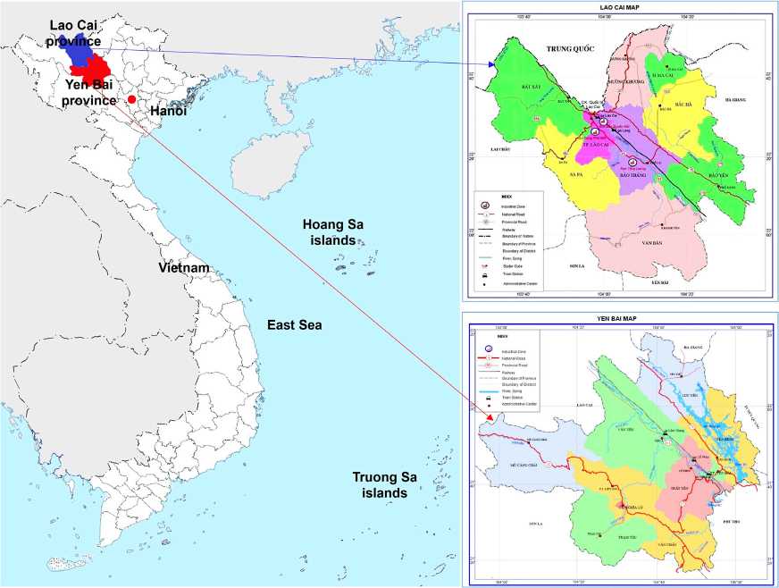
Рис. 1. Районы исследования в провинциях Лао Кай и Йень Бай, Вьетнам
2023;8(2):173–182
Материалы
Материалы исследования мультиспектральных данных радара Sentinel-2 MSI, полученные 29 ноября 2022 г. в провинции Лао Кай и 4 ноября 2022 г. в провинции Йень Бай, использовались для выявления незаконной добычи полезных ископаемых. Применение методики наложения изображений Sentinel-2 MSI дало возможность получить 13 спектральных диапазонов – от видимого и ближнего инфракрасного (VNIR) до коротковолнового инфракрасного (SWIR) при длине волн на орбитальной полосе 290 км. Пространственное разрешение изображения Sentinel-2 MSI находилось в диапазоне от 10 до 60 м, в которых видимый (2, 3, 4) и ближний инфракрасный (8) диапазоны имеют пространственное разрешение 10 м (табл. 1).
Изображение радара Sentinel-2 MSI предварительно обработано. Удалены облака и вырезана информация по границам областей исследования (рис. 2). Это изображение представляет собой продукт уровня L2A, загруженный с вебсайта Copernicus Open Access Hub ( https://scihub.copernicus.eu ), который, в свою очередь, представляет собой изображения отражательной способности нижней части атмосферы (BOA), полученные из соответствующих продуктов уровня 1C.
Методология
Мультиспектральная обработка снимков зондирования радаром Sentinel-2 MSI была проведена с учeтом атмосферной и геометрической коррекций. Процесс коррекции геометрии снимков устраняет геометрические ошибки и преобразует координаты изображения,
Таблица 1
Изображения Sentinel-2 MSI
|
Каналы |
Спектральный диапазон, µм |
Пространственное разрешение, м |
|
Прибрежный аэрозоль |
0,421–0,457 |
60 |
|
Синий |
0,439–0,535 |
10 |
|
Зеленый |
0,537–0,582 |
10 |
|
Красный |
0,646–0,685 |
10 |
|
Красный край растительности |
0,694–0,714 |
20 |
|
Красный край растительности |
0,731–0,749 |
20 |
|
Красный край растительности |
0,768–0,796 |
20 |
|
Ближний ИК |
0.767–0.908 |
10 |
|
Красный край растительности |
0,848–0,881 |
20 |
|
Водяной пар |
0,931–0,958 |
60 |
|
Коротковолновый инфракрасный – перистое облако |
1,338–1,414 |
60 |
|
Коротковолновый инфракрасный |
1,539–1,681 |
20 |
|
Коротковолновый инфракрасный |
2,072–2,312 |
20 |
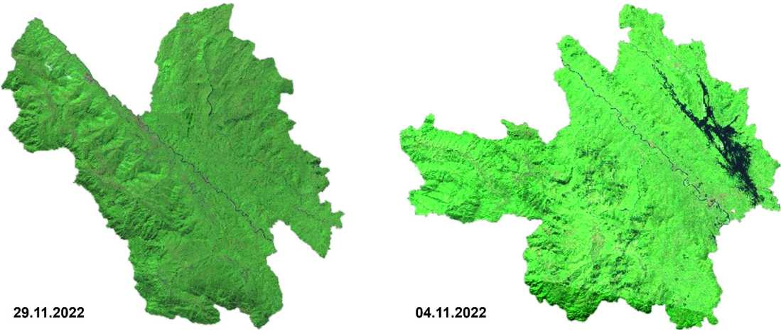
Рис. 2. Изображения Sentinel-2 MSI в провинциях Лао Кай и Йень Бай после предварительной обработки и вырезания по границам областей исследования
ГОРНЫЕ НАУКИ И ТЕХНОЛОГИИ https://mst.misis.ru/
2023;8(2):173–182 Tran X. B. et al. Detection of violations of open-pit mining lease boundaries...
сделанные радаром Sentinel-2 MSI, в локальные координаты (VN-2000), которые согласуются с системой координат границы участка лицензирования.
Спектральные диапазоны с пространственным разрешением 10 м используются для обнаружения участков незаконной добычи полезных ископаемых. Эти диапазоны были выбраны из-за самого высокого пространственного разрешения среди диапазонов MSI Sentinel-2, что позволило обеспечить обнаружение участков незаконной добычи полезных ископаемых.
На следующем этапе снимки лицензионных границ месторождений полезных ископаемых накладываются на спутниковые снимки Sentinel-2 MSI, после чего производится сравнение границ лицензионных участков добычи с фактическими. Методика оцифровки используется в этом случае для оценки зоны эксплуатации за допустимой границей в соответствии со схемой методологии обнаружения незаконного расширения лицензионных участков добычи (рис. 3).
Научно-методическое обоснование решений
-
а) Описание общих (базовых) методов обработки мультиспектральных снимков Sentinel-2 MSI
Чтобы собрать данные изображений Sentinel-2 MSI из базы данных Copernicus Open Access Hub, необходимо выбрать координаты области исследования и другие условия (тип изображения, уровень обработки, облачность, время съемки и т.п.) для сбора изображений. На рис. 4 показан процесс выбора и загрузки изображений Sentinel-2 MSI с веб-сайта https://scihub . copernicus.eu.
Спектральные каналы с пространственным разрешением 10 м (2, 3, 4 и 8) используются для обнаружения незаконного расширения майнинга.
-
б) Модели преобразования координат изображений в локальные координаты
Изображения Sentinel-2 MSI были получены из базы данных Copernicus в системе координат WGS 84. Эти изображения были преобразованы в местную
Данные Sentinel-2 MSI (видимые и БИК спектральные каналы)
Лицензионные границы месторождений полезных ископаемых
Предварительная обработка
Геометрическая коррекция
Улучшение качества изображения
Выявление участков добычи полезных ископаемых
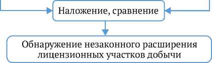
Рис. 3. Этапы методики обнаружения незаконного расширения майнинга, по данным Sentinel-2 MSI
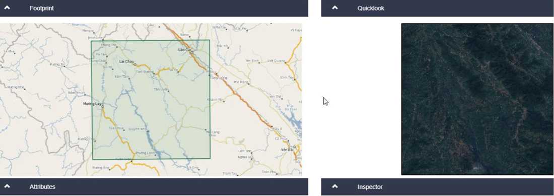
Рис. 4. Сбор данных изображений Sentinel-2 в базе данных Copernicus
2023;8(2):173–182
систему координат (VN2000) (Департамент геодезии, карт и географической информации, Министерство природных ресурсов и окружающей среды Вьетнама) на основании зависимостей:
X = ∆ x 0 + k ( X ′ + ε 0 Y ′ - ψ 0 Z ′ );
Y = ∆ y 0 + k (- ε 0 X ′ + Y ′ + ω 0 Z ′ );
Z = ∆z0 + k(ψ0X ′ - ω0Y ′ + Z ′), где X, Y, Z – координаты в декартовой системе координат, которые необходимо преобразовать в метры; X ′, Y ′, Z ′ – координаты в декартовой системе координат смещения, м; ∆x0, ∆y0, ∆z0 – параметр смещения начала координат, м; ω0, ψ0, ε0 – представляют собой три угла поворота оси координат (поворот Элеге), соответствующие осям X, Y, Z, рад; k – коэффициент масштаба.
в) предложения по совершенствованию методики (или алгоритма) обработки изображений для повышения точности с учeтом атмосферной и геометрической коррекций
Изображение Sentinel-2 MSI предварительно обработано. После геометрической коррекции и преобразования в местную систему координат (VN2000) удалены облака и вырезана информация по границам областей исследования.
Процесс фильтрации облака изображений Sentinel-2 выполняется на платформе Google Earth Engine (GEE). Google Earth Engine – это облачная платформа геопространственного анализа, которая позволяет пользователям визуализировать и анализировать спутниковые изображения Земли. В наборе данных GEE хранятся данные дистанционного зондирования спутниковых систем за последние 40 лет, а также вычислительные инструменты, необходимые для анализа и использования этого огромного хранилища данных без загрузки компьютеров. Мало того, данные из GEE можно использовать в другом
программном обеспечении (QGIS, GIS, Foris) для оптимизации данных.
Для фильтрации выборки в исследовании использовался эталонный набор изображений Sentinel-2, в котором выбранные изображения имели покрытие облачностью менее 80 %. Алгоритм cloudScore используется для проведения облачной фильтрации на платформе GEE, кроме того, алгоритм Temporal Dark Outlier Mask (TDOM) используется для идентификации пикселей теней облаков. Результаты фильтрации облака изображений Sentinel-2 MSI и обрезки по границам исследуемой области представлены на рис. 2.
г) новая методика и алгоритм
Новым в этом исследовании является использование платформы облачных вычислений GEE для обработки данных спутниковых изображений Sentinel-2 MSI. GEE работает через онлайн-интерфейс приложения JavaScript (API), называемый Code Editor. Это подходящее решение для сегодняшних условий большого объема данных дистанционного зондирования, в которых спутниковые системы дистанционного зондирования обеспечивают огромный источник данных. Использование платформы GEE также позволяет улучшить возможности мониторинга и обнаружения областей изменения на поверхности Земли по разновременным данным дистанционного зондирования.
Применяемые впервые спектральные диапазоны съeмки местности с самым высоким пространственным разрешением среди диапазонов MSI Sentinel-2 – 10 м (видимый и БИК-диапазоны) – позволили подтвердить обнаружение участков незаконной добычи полезных ископаемых, скрытых в сплошных зарослях джунглей. Наличие доступных мультиспектральных изображений Sentienl-2 MSI с коротким временным разрешением (5 дн) способствовало эффективному использованию их в мониторинге территорий добычи полезных ископаемых.
Таблица 2
Сравнение лицензированных и фактических площадей добычи полезных ископаемых на отдельных рудниках в провинции Лао Кай
|
Горнодобывающее предприятие |
Адрес |
Лицензионная площадь добычи, га |
Фактическая площадь добычи, га |
Разница в площади добычи, га |
|
Апатит |
Коммуна Чиенг Кен (Chieng Ken), район Ван Бан (Van Ban) |
4,02 |
9,80 |
5,78 |
|
Каолин |
Коммуна Ланг Дзан (Lang Giang), район Ван Бан |
4,33 |
6,4 |
2,07 |
|
Апатит |
Коммуна Бао Ха (Bao Ha), район Бао Йен (Bao Yen) |
12,55 |
20,41 |
7,86 |
|
Каолин |
Коммуна Ван Хоа (Van Hoa), город Лао Кай (Lao Cai) |
28,32 |
43,57 |
15,25 |
|
Апатит |
Коммуна Кам Дуонг (Cam Duong), город Лао Кай |
49,85 |
63,91 |
14,06 |
|
Железо |
Коммуна Во Лао (Vo Lao), район Ван Бан |
51,03 |
96,96 |
45,93 |
|
Апатит |
Коммуна Донг Туен (Dong Tuyen), город Лао Кай |
76,19 |
150,32 |
74,13 |
|
Апатит |
Коммуна Та Фои (Ta Phoi), город Лао Кай |
77,92 |
97,48 |
19,56 |
|
Железо |
Коммуна Куи Са (Quy Xa), район Ван Бан |
81,53 |
151,65 |
70,12 |
|
Апатит |
Коммуна Сон Туи (Son Thuy), район Ван Бан |
91,96 |
107,59 |
15,63 |
|
Медь |
Коммуна Кок Мы (Coc My), район Бат Сат (Bat Sat) |
207,78 |
525,76 |
317,98 |
2023;8(2):173–182
Результаты и обсуждение
Анализ космических снимков сканирования земной поверхности радаром Sentinel-2 MSI участков добычи полезных ископаемых открытым способом на рудниках показал, что фактические площади добычи на многих рудниках превышают лицензионные (табл. 2). К примеру, на 11 рудниках происходит значительное расширение незаконной эксплуатации участков добычи, на которых фактические площади рудников превышают лицензионную площадь в 2 раза (медный рудник в коммуне Кок Мы, район Бат
Tran X. B. et al. Detection of violations of open-pit mining lease boundaries...
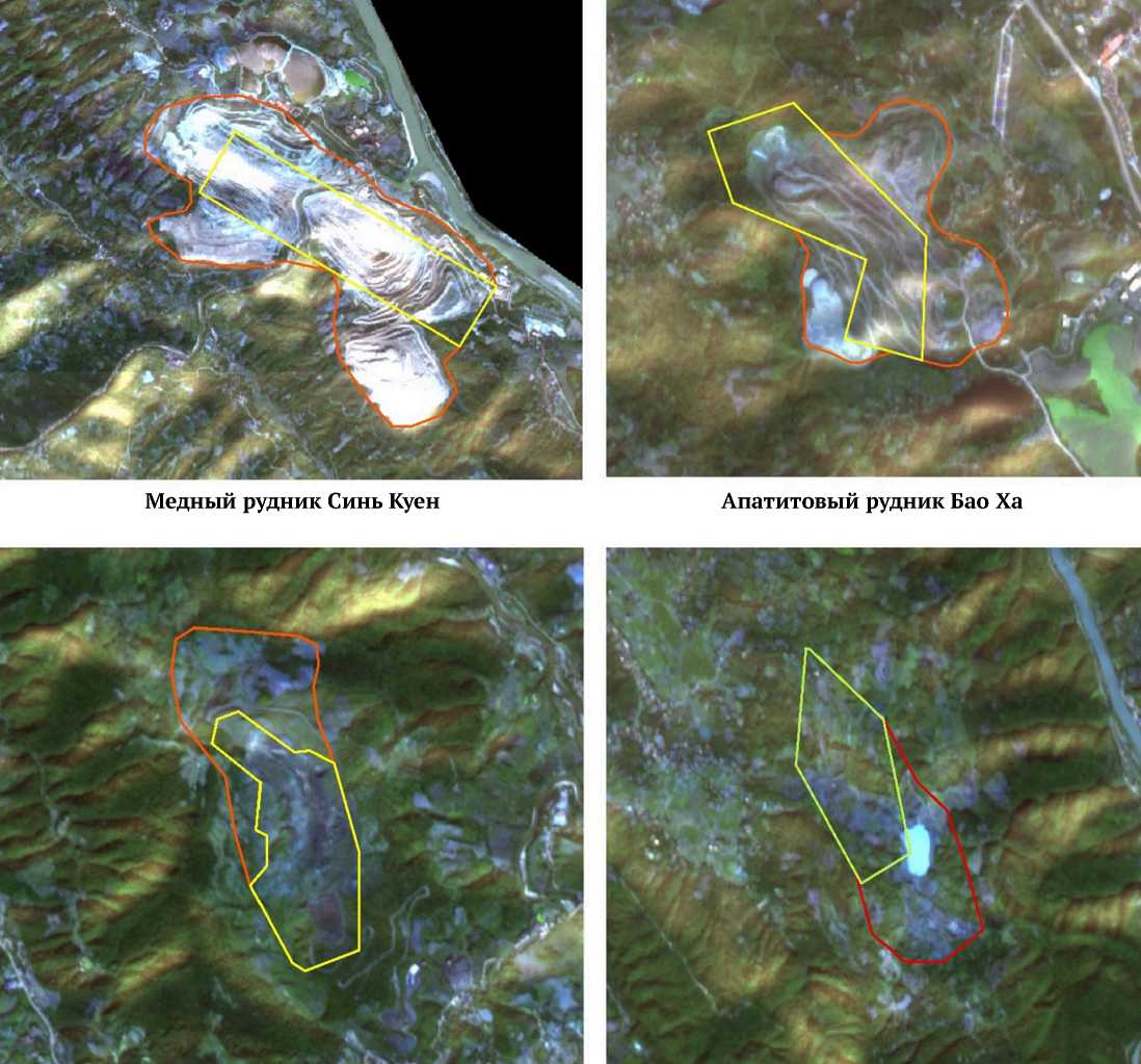
Сат; апатитовый рудник в коммуне Донг Туен, город Лао Кай) (рис. 5).
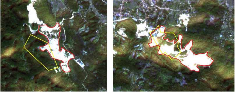
В провинции Йень Бай были проанализированы 12 участков открытых горных работ для оценки незаконного расширения зоны добычи (см. табл. 2). Анализ космических снимков фактических границ участков добычи полезных ископаемых (рис. 6) подтвердил незаконное расширение площади добычи полезных ископаемых пятью участками (см. табл. 2). Например, известняковый карьер (коммуна Йен Тханг, район Люк Йен) с лицензионной площадью 2,18 га фактически занимает площадь добычи 26,62 га (табл. 3).
Медный рудник Синь Куен
Апатитовый рудник Бао Ха
Железный рудник Ланг Винь
Железный рудник (Вьетнамская минерально-металлургическая компания)
Рис. 5. Космические снимки фактических (красный цвет) и лицензионных (желтый цвет) границ участков добычи полезных ископаемых в провинции Лао Кай, полученные радаром Sentinel-2 MSI https://mst.misis.ru/
2023;8(2):173–182
Таблица 3
Сравнение лицензированных и фактических площадей добычи полезных ископаемых на отдельных рудниках в провинции Йень Бай
|
Горнодобывающее предприятие |
Адрес |
Лицензионная площадь добычи, га |
Фактическая площадь добычи, га |
Разница в площади добычи, га |
|
Карьер белого мрамора |
Коммуна Йен Тханг (Yen Thang), район Люк Йен (Luc Yen) |
26,80 |
51,87 |
25,07 |
|
Фенспат |
Коммуна Тан Лап (Tan Lap), район Люк Йен |
5,01 |
16,25 |
11,24 |
|
Мраморный карьер |
Коммуна Йентэ (Yen The), район Люк Йен |
43,32 |
98,18 |
54,86 |
|
Мраморный карьер |
Коммуна Ман Сан (Mong Son), Yen Binh район |
10,01 |
45,85 |
35,84 |
|
Графит |
Коммуна Йен Тай (Yen Thai), Van Yen район |
11,65 |
24,70 |
13,05 |
|
Мраморный карьер |
Коммуна Луи До (Lieu Do), район Люк Йен |
49,80 |
65,88 |
16,08 |
|
Карьер белого мрамора |
Коммуна Тан Линь (Tan Linh), район Люк Йен |
5,21 |
16,48 |
11,27 |
|
Мраморный карьер |
Коммуна Ан Фу (An Phu), район Люк Йен |
5,91 |
36,84 |
30,93 |
|
Железо |
Коммуна Хунг Хан (Hung Khanh), район Чан Йен (Tran Yen) |
113,00 |
146,63 |
33,63 |
|
Известняковый карьер |
Коммуна Йен Тан (Yen Thang), район Люк Йен |
2,18 |
28,80 |
26,62 |
|
Карьер |
Коммуна Йен Тан, район Люк Йен |
2,18 |
9,96 |
7,78 |
|
Мраморный карьер |
Коммуна Ан Фу, район Люк Йен |
16,10 |
43,58 |
27,48 |
Карьер (Компания по добыче Карьер и переработке камня Да Ту) (компания RK Marble Vietnam)
Карьер (компания Phanxipang) Карьер (компания Thai Duong) Карьер (компания Hung Dai)
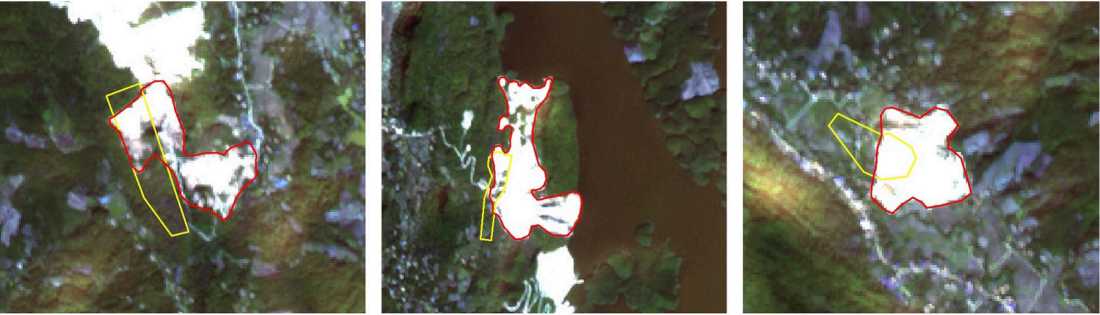
Рис. 6. Космические снимки фактических (красный цвет) и лицензионных (желтый цвет) границ участков добычи полезных ископаемых в провинции Йень Бай, полученные радаром Sentinel-2 MSI
ГОРНЫЕ НАУКИ И ТЕХНОЛОГИИ https://mst.misis.ru/
2023;8(2):173–182 Tran X. B. et al. Detection of violations of open-pit mining lease boundaries...
Выводы
В ноябре 2022 г. была проведена обработка космических снимков сканирования земной поверхности радаром Sentinel-2 MSI участков нахождения рудников в провинциях Лао Кай и Йень Бай (северный регион Вьетнама). Целью обработки являлись обнаружение и оценка площади незаконной добычи полезных ископаемых. Полученные результаты показывают, что фактическая площадь добычи полезных ископаемых на многих рудниках в изучаемых районах значительно превышает границы, указанные в лицензии. Снимки сканирования земной поверхности радаром Sentinel-2 MSI имеют самое высокое пространственное разрешение – до 10 м. Пятидневное временное разрешение съeмки контролируемой территории позволило эффективно использовать снимки для мониторинга и раннего обнаружения нарушения лицензионных границ участков добычи полезных ископаемых. Полученные результаты исследований предоставляют важную информацию, которая позволит менеджерам проводить мониторинг и надзор за добычей полезных ископаемых в границах, утверждeнных лицензией.
Информация об авторах
2023;8(2):173–182
Список литературы Выявление нарушений границ разработки месторождений полезных ископаемых открытым способом с использованием данных Sentinel-2 MSI на примере провинций Северного Вьетнама Лао Кай и Йень Бай
- Kozinska P., Gorniak-Zimroz J. A review of methods in the field of detecting illegal open-pit mining activities. In: IOP Conference Series: Earth and Environmental Science. XXI Conference of PhD Students and Young Scientists (CPSYS 2021). 23-25 June 2021 (virtual), Wroclaw, Poland. 2021;942:012027. https://doi.org/10.1088/1755-1315/942/1/012027
- Levkin Yu. M. The usage of modern surveying instruments in mining. In: Nguyen Q. L., Pham T. L., Nguyen V. N. et al. (Eds.) The Proceeding of Geo-spatial Technologies and Earth Resources Conference (GTER 2017). 5-6 October 2017, Hanoi, Vietnam. Hanoi: Publ. House for Science and Technology; 2017. Pp. 307-311.
- Liu Y., Zhong C., Bai B., Zhou Y. Assessment of government supervision on the loss of sea sand resource in China. Economic Research. 2022;35(1):2732-2746. https://doi.org/10.1080/1331677X.2021.1977672
- Forkuor G., Ullmann T., Griesbeck M. Mapping and monitoring small-scale mining activities in Ghana using Sentinel-1 time series (2015-2019). Remote Sensing. 2020;12(6):911. https://doi.org/10.3390/rs12060911
- Owusu-Nimo F., Mantey J., Nyarko K. B., et al. Spatial distribution patterns of illegal artisanal small scale gold mining (Galamsey) operations in Ghana: A focus on the Western Region. Heliyon. 2018;4(2):e00534. https://doi.org/10.1016/j.heliyon.2018.e00534
- Merugu S., Jain K. Change detection and estimation of illegal mining using satellite images. In: Proceedings of 2nd International Conference on Innovations in Electronics and Communication Engineering (ICIECE-2013). 9-10 August 2013, Hyderabad, India. Pp. 246-251.
- Hu Z., Ge L., Li X., Rizos C. Designing an illegal mining detection system based on DinSAR. In: 2010 IEEE International Geoscience and Remote Sensing Symposium. 25-30 July 2010, Honolulu, HI, USA. Pp. 3952-3955. https://doi.org/10.1109/IGARSS.2010.5652978
- Xia Y., Wan Y. InSAR- and PIM-based inclined goaf determination for illegal mining detection. Remote Sensing. 2020;12(23):3884. https://doi.org/10.3390/rs12233884
- Wang L., Yang L., Wang W. et al. Monitoring mining activities using Sentinel-1A InSAR coherence in open-pit coal mines. Remote Sensing. 2021;13(21):4485. https://doi.org/10.3390/rs13214485
- Zhang B., Wu S., Ding X. et al. Use of multiplatform SAR imagery in mining deformation monitoring with dense vegetation coverage: A case study in the Fengfeng Mining Area, China. Remote Sensing. 2021;13(16):3091. https://doi.org/10.3390/rs13163091
- Le M. H., Do T. P. T., Vu T. T. H. et al. Using optical satellite images to detect the signs of illegal mining in Thai Nguyen province. Science of Natural Resources and Environment. 2018;20:30-42. (In Vietnamese)
- Trinh L. H., Zablotskii V. R. The application of Landsat multi-temporal thermal infrared data to identify coal fire in the Khanh Hoa coal mine, Thai Nguyen province, Vietnam. Izvestiya. Atmospheric and Oceanic Physics. 2017;53(9):1181-1188. https://doi.org/10.1134/S0001433817090183
- Trinh L. H. Hydrothermal minerals mapping using based on remotely sensed data from Sentinel 2 sattelite: a case study in Vinh Phuc Province, Northern Vietnam. Mining Science and Technology (Russia). 2019;4(4):309-317. https://doi.org/10.17073/2500-0632-2019-4-309-317
