A multidisciplinary study of burial mounds and a reconstruction of the climate of the Turan-Uyuk depression, Tuva, during the Scythian period

Author: Kilunovskaya M.E., Semenov V.A., Glukhov V.O., Prikhodko V.E., Blyakharchuk T.A.
Journal: Archaeology, Ethnology & Anthropology of Eurasia @journal-aeae-en
Section: The metal ages and medieval period
Article in issue: 4 т.45, 2017.
Free access
Short address: https://sciup.org/145145345
IDR: 145145345 | DOI: 10.17746/1563-0110.2017.45.4.082-092
Text of the article A multidisciplinary study of burial mounds and a reconstruction of the climate of the Turan-Uyuk depression, Tuva, during the Scythian period
Archaeological research provides various information on subsistence activities and funerary rites of past ethnic communities, and also on changes in paleosols and vegetation as compared to their modern background analogs, making it possible to reconstruct the past environment. Currently, insufficient information on the Holocene environmental settings and their chronology for the Tuva is available. For instance, the Holocene climate of the Turan-Uyuk depression in Tuva has been described on the basis of palynological analysis of the stratigraphic column at Beloye Ozero (Dirksen, Chugunov, 2007). The palynological data are also available for the higher altitudes in the Altai-Sayan highlands (Yamskikh, 1983, 1995; Chistyakov et al., 1997; Blyakharchuk et al., 2007; Blyakharchuk, Chernova, 2013). Present data have been collected during the rescue archaeology works forming part of the project of the Elegest-Kyzyl railroad construction in Tuva. This work is aimed at multidisciplinary study of the burial mounds of the Scythian period in this region, in order to identify the features of the funerary rite and to reconstruct the past climatic and environmental conditions on the basis of paleopedological and palynological analyses.
Materials and methods
The cemetery of Beloye Ozero-3, studied in 2013, is located in the Valley of the Kings in the Turan-Uyuk depression, five kilometers from the village of Arzhan and 83 km from Kyzyl, in the Piy-Khemsky District of the Tuva Republic (52º04.458′ N; 93º44.092′ E; 840 m asl) (see Figure ). The valley, 80 km long and 30–40 km wide, is delimited by the Kurtushibinsky and Uyuksky mountain-ranges of the Western Sayan. The area consists of a swampy depression containing several saline lakes, each named Beloye Ozero. The Uyuk and Turan are the main local rivers, belonging to the Yenisei River basin. The climate in the depression is sharp continental; the average yearly air temperature is –3.0 ºC; the average January temperature is –34.9 ºC; that of July 16.9 ºC. The annual precipitation is 330 mm, of which 70 % fall in summer (data from the Turan meteorology station).
The major part of the soils in the depression belongs to the steppe cryoarid type, dominated by the southern black earth (chernozem) soils and dark chestnut (brown) soils (Nosin, 1963; Volkovintser, 1978). Prior to the early 1990s, the area between the mounds was plowed; currently it is used as a pasture. The most typical vegetation types include couch grass ( Elytrigia repens ), Cleistogenes squarrosa , sedge ( Carex duriuscula ), bindweed ( Convolvulus arvensis ), cinquefoil ( Potentilla bifurca ), wormwood ( Artemisia scoparia , A. frigida ),
94 Е
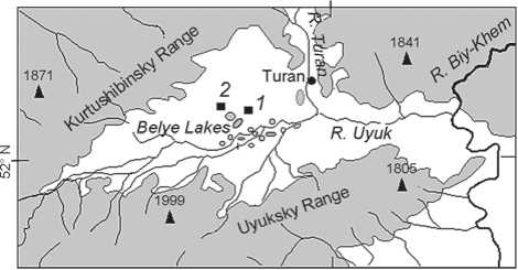
Map showing location of Beloye Ozero-3 cemetery ( 1 ) and Arzhan-2 mound ( 2 ).
palm-grass ( Setaria viridis ), goosefoot ( Chenopodium album ), pea shrub ( Caragana pygmaea ), and others. Currently, after overburdening of pastures, the vegetative communities have not been recovered yet, owing to the proximity to the stock-keeper station and because of the insufficient restoration period. The river valleys are vegetated by stepped forests of birch, poplar, and willow. The lower parts of the forest-belt of the surrounding mountain ranges are covered by larch, birch, spruce, and pine forests (Kuminova, 1983; Dubrovsky et al., 2014).
The soil-archaeological approach implies the comparison of the paleosols buried under archaeological sites with the modern background soils. Soil samples are also subjected to spore-pollen analysis. Such complementary studies provide more comprehensive information enabling the reconstruction of paleoecological changes occurring through time and space (Chistyakov et al., 1997; Prikhodko et al., 2014; Chendev et al., 2016; Gerasimenko, 1997).
We have studied the morphological features of two background soils and four paleosols: alkalinity, salinity, carbonate neoformations, gypsum and readily soluble salts, and also their forms, composition, and depth of deposition. Soil samples were taken layer by layer, at an interval of 10 cm up to 1 m in depth, and an interval of 20 cm from a depth of 1–2 m. For the palynological analysis, paleosol samples were collected from the surface layer of 0–2 cm from four mounds; for the pedological analysis, paleosol samples were taken at an interval of 0–10 cm to a depth of 30 cm from the same mounds. Five samples of background soil were taken from a depth of 0–10 cm in the area between the mounds.
The analyses were executed in the Center of Common Facilities of the Institute of Physicochemical and Biological Problems in Soil Science, Russian Academy of Sciences, using standard techniques: Corg. was determined by Tyurin’s method, pH by potentiometry (soil : water = 1.0 : 2.5), CO2 in carbonates by titrimetry, grain-size distribution by pyrophosphate method, cation exchange capacity by Schollenberger’s method, and labile phosphorus and potassium by Machigin’s method (Vorobieva, 1998). The radiocarbon analysis of ancient wood from burials was carried out in the Radiocarbon Laboratory of the Institute of Material Culture of the Russian Academy of Sciences (headed by G.I. Zaitseva). Calibration was carried out using the program (Stuiver, Reimer P.J., Reimer R., 2005). Identification of pollen and spores from the layer 0–2 cm of paleosols was performed under the supervision of Doctor of Geographical Sciences and Professor N.P. Gerasimenko, according to the established procedure (1997). Soil samples (100 g) were successively treated with hydrochloric acid (HCl, 10 %), sodium pyrophosphate (15 %), again with hydrochloric acid (HCl, 10 %), potassium hydroxide (10 %), and hydrofluoric acid (40 %). Residual palynomorphs were separated by heavy liquid (CdI2 + KI) with specific weight of 2.2 g/cm3.
Palynological analysis was performed by T.A. Blyakharchuk, using a light microscope with 400x magnification. Pollen and spores were assessed by ecological groups: xerophytes, mesophytes, hydrophytes, xerohydrophytes, and ruderals (Kuminova, 1983). In the Tuva environment, Poaceae were attributed to the mesophytic group rather than to the steppe community, because their pollen content is higher in the more humid ecotopes of highlands and in northern meadowsteppes of the region than in dryer southern steppe areas (Blyakharchuk, Chernova, 2013). A multiplicity of ecological niches of club-moss ( Lycopodiella inundata ) makes it possible to attribute this plant to mesophytic, hydrophytic, and ruderal groups. In Tuva, club-moss has been included into the ruderal group because it expands quickly on disturbed and water-logged soils on lake and river banks. Spirea ( Spiraea alpina ) and dwarf birch, forming thickets in Tuva highlands, have been attributed to the mesophytic group.
Results of the archaeological studies
The mounds under study demonstrate certain different features in their construction and funerary rite. Each mound consists of tumulus 50–90 cm high, composed of stones and humus sandy loam, and a spoil-heap of reddish sandy loam from the main grave. Along the edge of the ground structure of each of three mounds, there is a curb circle made of large stones. Mound No. 3, encircled with a shallow ditch, is reinforced with large slabs instead of stones. Larger stones are placed at the edge of the tumulus, but in the center of the mound they are absent. In mound No. 4, firstly a layer of soil was added, then a grave-pit was dug out, over which an earthen tumulus overlaid by stones was formed.
The spoil-heaps, 50–80 cm high, are covered with stones placed in one or two layers. In the heaps, accompanying burials were found, mostly of infants. Mound No. 1 revealed a child burial in a stone cist. The spoil-heap of mound No. 3 shows one burial in a wooden cribwork, and four burials in stone cists. Mound No. 4 contained a cenotaph paved with stones, possibly imitating an infant or placenta burial. In addition, small stone triangles have been discovered under the spoil-heap and close to the peripheral ring. These triangles represent ritual burials that are interpreted as placenta burials of Tuvan and Khakas people, according to the ethnographic data. The mounds are encircled by the ritual peripheral rings of stones.
Mound No. 4 shows a dromos running through the spoil-heap in a SW direction; mound No. 3 has a dromos running in a NW direction. These were possibly either looting-passages, or passages for secondary burials. In mound No. 4, the dromos reached the ceiling of the cribwork and was filled with stones.
The burial pits had rectangular shape, were about 4 m deep, and were oriented with their corners according to the cardinal points. The pits above the cribwork were filled with dark gray earth, and closer to the walls with red sandy loam. In the central pit at mound No. 4 (possibly at mound No. 1), at a depth of 2 m, a step was made, on which an additional wooden frame with a ceiling was placed, which is typical of the Early Uyuk–Aldy-Bel tradition. Inside the pits, the cribworks were located, covered with several layers of half-logs or beams. The ceiling and floor were made of wooden boards and were directed NW–SE. The layer of birch-bark was placed between the upper and lower layers of the ceiling in burial mounds No. 2 and 3; birch-bark was also found on top layer of cribwork in burial mound No. 3. The lower logs of the ceiling had special cuts made for attaching them to the logs of the cribwork. In total, 15 logs ~ 3 m long and ~ 0.2 m wide have been found.
The cribworks, about 1 m high, were made of 3 or 4 rows of logs joined with saddle notch, and were oriented with their corners according to the cardinal points. The external dimensions of the cribworks are 3 x 3 m; the internal dimensions are 2.5 x 2.5 m. The cuts for inserting floor boards were made in the lowest layer of logs. Earthen bedding to even the floor was used in some places under the boards.
The number of buried individuals and their poses have not been identified, because all the graves were looted. All the ceilings were broken in their central parts, possibly by the looters aiming to get access to the burials. Only in mound No. 1, in the northwestern and southeastern edges of the central grave, were skeletal remains found, which had been likely retrieved from the bottom of the central grave-pit and put on wooden platforms. In mound No. 2, inside the central grave, a man and a child were buried, apparently after looting. These burials may have been sacrificial.
Grave goods are mostly represented by fragments of golden plates, sewn on the clothing, that showed images of griffins, ibex, and lion, typical of the Uyuk culture. A belt with plates on the leather base, with bronze clips, is a feature of the Aldy-Bel culture. The bone and bronze arrowheads with short strikers and long stems correspond to the Early Scythian period in Tuva.
In the ritual peripheral rings of stones, Scythian pottery was found. This is represented by jars of two types: made of red clay and of gray clay, with the marked rims and appliquéd fillets with notches thereunder. Such vessels are typical mostly of the Aldy-Bel culture. A medieval hoard—an intact suit of body-armor of brigandine type— was discovered in the tumulus of mound No. 4.
All excavated burial sites demonstrate the features corresponding to the Uyuk culture of the Scythian period.
Results of palynological analysis
Characterization of the current vegetation was based on the published data of the spore-pollen analysis of two soil samples taken 2 km from the study-area (Dirksen, Chugunov, 2007). The amount of spores was determined as the difference between 100 % and the sum of pollen of woody and herbaceous groups (Table 1). The share of grass and shrubs in the overall pollen composition of modern soil is 78 %; that of wood is 22 %, including pollen grains of pine ( Pinus sibirica and P. Sylvestris together) 9 %, fir ( Abies sibirica ) and larch ( Larix ) 2 %, and spruce ( Picea obovata ) less than 1 %. Among herbaceous pollen, dominates pollen of wormwood ( Artemisia )—36 % and 41 %; Poaceae and sedge shares are 7 % and 16 % each, chenopods (Chenopodiaceae) 3 % and 5 %, Ephedra and Asteraceae 1 % and 3 % each.
In each paleosol sample, 454–555 pollen and spore grains were identified. Their species diversity varies from 21 to 48 pollen types. Spores of ferns and mosses in paleosol samples composed from 8 to 30 %, those in the background samples 24 to 27 %. The composition of fossilized pollen spectra is dominated by the herbaceous pollen grains; their share in paleosols is greater than in modern soil samples; in contrast, the share of arboreal palynomorphs is lower: 7–12 %. The latter are dominated by the pollen of Siberian pine ( Pinus sibirica )—from 1 % to 11 %; palynomorphs of Scot’s pine ( P. sylvestris ) and larch ( Larix ) total to 1–5 %; pollen grains of spruce ( Picea obovata ), fir ( Abies sibirica ), and birch ( Betula ) are few.
The share of pollen of xerophyte-steppe subgroup in paleosols varies from 41 % to 50 %, where the wormwood pollen predominates. The proportion of pollen of the mesophytic plants is also great: from 8 % to 32 %. The main representatives of this subgroup are palynomorphs of spirea (Spiraea) 2–12 %, St. John’s wort (Hypericum type), Poaceae, and Rosaceae. Cichorioideae, attributed by the present authors to ruderals, also belong to the mesophytic group. The amount of pollen and spores of hydrophytic plants is quite small: from 4 % to 8 %. These are dominated by hypnum mosses spores (Bryales) and various types of club-mosses (Lycopodium). The smallest share is represented by sedges and horsetail. In addition, a considerable number of micro-pieces of charcoal and mushroom spores are recorded. The proportions of Poaceae and sedges pollen in the modern spectra are 7–16 % each, those in the fossilized samples are 4–8 % and 0.4–3.0 %, respectively. It is known that pollen of Poaceae is poorly preserved in paleosols.
In this region, dry areas are occupied by steppe plants, and humid areas are dominated by mosses, club-mosses, horsetails, and sedges.
The soil under study also contains clumps of pollen (1–2 %)—a few pollen grains of the same species that failed to ripe and to disintegrate into separate grains. This might be the result of the extreme climatic conditions or anthropogenic impact, for instance trampling and damage of plants by cattle (Schlütz, Lehmkuhl, 2007).
Features of soil morphology
The thickness of the former arable layer is 25 cm. The layer of humus containing horizons A1 and AB is up to 40–45 cm thick. Carbonate neoformations have been noted at a depth of 35–42 cm and up to 200 cm (the bottom of the section). The layer of most dense accumulation of carbonates lies at a depth of 40–80 cm; their neoformations are abundantly represented by powdery form.
The study of space between the mounds has shown that horizon A1 was removed from the area up to 50 m from the mounds during the mounds’ construction and was moved to the mounds’ embankments during the Scythian period. New soil horizons have been formed around the mounds over a period of 2500 years; at a distance of 20 m from the mound, the soil horizon A1 is 10–15 cm thick; the thickness of horizon AB does not exceed several centimeters. At a distance of 20–50 m from the mound, the thickness of A1 gradually grows to 20– 25 cm, that of AB up to 10 cm, getting close to the thickness of modern soil layers.
The buried soils from horizons A1 and AB remain unaffected by hydrochloric acid. In general, the morphology of paleosols is largely similar to that of background soils. The soils under study are represented by dark chestnut, moderately thick sandy loam.
Chemical composition of soils
In the background sandy loam soils, the shares of finegrained fractions (fine-dust and silt, accumulating
Table 1. Pollen compositions of modern and fossil soils from the studied mounds
|
Palynomorphs |
Background soils * |
Mounds |
||||
|
No. 3 |
No. 2 |
No. 1 |
No. 4 |
|||
|
1 |
2 |
2565 BP |
2520 BP |
2425 BP |
2390 BP |
|
|
1 |
2 |
3 |
4 |
5 |
6 |
7 |
|
Trees |
||||||
|
Pinus sibirica + P. sylvestris |
19 |
18 |
3 |
15 |
3 |
9 |
|
P. sylvestris с |
– |
– |
1 |
4 |
1 |
2 |
|
P. sibirica |
– |
– |
1 |
11 |
1 |
7 |
|
Abies sibirica |
2 |
1.3 |
0.4 |
0.3 |
– |
– |
|
Picea obovata |
0.4 |
0.4 |
– |
0.3 |
– |
0.3 |
|
Larix |
1 |
1 |
4 |
5 |
4 |
3 |
|
Betula pendula |
– |
– |
– |
0.3 |
– |
2 |
|
Betula alba |
– |
– |
– |
0.3 |
– |
0.3 |
|
Salix |
– |
– |
0.2 |
– |
– |
2 |
|
Total |
22 |
21 |
7 |
21 |
7 |
16 |
|
Xerophytes |
||||||
|
Artemisia |
41 |
36 |
40 |
41 |
49 |
47 |
|
Ephedra |
3 |
2 |
1 |
5 |
0.6 |
0.3 |
|
Limonium vulgare |
– |
– |
– |
– |
– |
0.8 |
|
Total |
44 |
38 |
41 |
46 |
50 |
48 |
|
Mesophytes |
||||||
|
Androsace |
– |
– |
3 |
5 |
1 |
0.5 |
|
Aster (type) |
0.7 |
2 |
0.8 |
1.1 |
0.2 |
2 |
|
Betula nana |
3 |
10 |
– |
1 |
0.2 |
3 |
|
Bupleurum |
– |
– |
0.4 |
– |
– |
0.5 |
|
Dryas |
– |
– |
0.7 |
– |
– |
– |
|
Fabaceae |
– |
– |
0.2 |
– |
1 |
1.1 |
|
Galium |
– |
– |
– |
– |
0.2 |
0.3 |
|
Geranium |
– |
– |
0.4 |
0.3 |
– |
0.5 |
|
Hypericum (type) |
– |
– |
1 |
– |
8 |
2 |
|
Lamiaceae |
– |
– |
0.8 |
– |
– |
0.3 |
|
Phlomis |
– |
– |
– |
– |
0.2 |
0.3 |
|
Pedicularis |
– |
– |
0.6 |
– |
– |
0.5 |
|
Poaceae |
14 |
16 |
4 |
6 |
4 |
8 |
|
Polygonum alpinum |
– |
– |
– |
– |
– |
0.8 |
|
Ranunculaceae |
– |
– |
0.2 |
0.3 |
– |
– |
|
Rosaceae |
– |
– |
2 |
0.3 |
5 |
1.1 |
Table 1 (end)
|
1 |
2 |
3 |
4 |
5 |
6 |
7 |
|
Rumex |
– |
– |
0.2 |
– |
– |
0.3 |
|
Saxifraga |
– |
– |
3 |
1 |
– |
2 |
|
Scrophulariaceae |
– |
– |
– |
1 |
– |
– |
|
Spiraea (type) |
– |
– |
12 |
11 |
12 |
2 |
|
Total without spore plants |
18 |
28 |
29 |
27 |
33 |
28 |
|
Trilete ferns |
– |
– |
– |
0.7 |
– |
0.4 |
|
Monolete ferns |
– |
– |
0.9 |
3.3 |
– |
– |
|
Total spore plants |
– |
– |
0.9 |
4 |
– |
0.4 |
|
Xerohydrophytes |
||||||
|
Carex |
14 |
7 |
1 |
2 |
0.4 |
2.7 |
|
Equisetum horsetail (spore) |
– |
– |
– |
1 |
– |
2.3 |
|
Hydrophytes |
||||||
|
Bryales |
– |
– |
1.3 |
2.0 |
1.1 |
2.1 |
|
Lycopodium clavatu m |
– |
– |
1.1 |
– |
1.1 |
– |
|
Lycopodium lagopus |
– |
– |
– |
3.1 |
1.1 |
2.6 |
|
Lycopodum dubium |
– |
– |
0.9 |
0.7 |
0.2 |
3.2 |
|
Sphagnum |
– |
– |
0.2 |
0.7 |
0.2 |
1.3 |
|
Total |
– |
– |
4 |
7 |
4 |
8 |
|
Ruderals |
||||||
|
Cannabis |
– |
– |
– |
1 |
– |
– |
|
Cichoirioideae |
– |
– |
19 |
1 |
9 |
1 |
|
Chenopodiaceae |
3 |
5 |
0.4 |
1 |
0.2 |
1 |
|
Plantago |
– |
– |
0.2 |
0.3 |
0.4 |
0.3 |
|
Urtica |
– |
– |
1 |
0.3 |
0.6 |
2 |
|
Total without spore plants |
3 |
5 |
21 |
4 |
10 |
4 |
|
Lycopodiella inundata |
– |
– |
3 |
11 |
9 |
18 |
|
Spores of ferns and mosses, % |
27 |
24 |
8 |
23 |
14 |
30 |
|
Pollen clumps, % |
– |
– |
1.3 |
1.1 |
1.8 |
1.5 |
|
Fungi spores, % |
– |
– |
42 |
24 |
7 |
19 |
|
Total of palynomorphs, spec. |
– |
– |
555 |
454 |
549 |
531 |
*Data after: (Dirksen, Chugunov, 2007). The palynomorphs content < 0,5 %, found in one paleosol, is not provided in the Table, but is included into total scores of various ecological groups.
organic carbon and nutrients) reach 8–11 % in total (Table 2). Their distribution throughout the profile is rather even. The pH value of the background soil water extract varies across the profile from the mildly alkaline (8.1) in the upper horizons to strongly alkaline
(9.0–9.4) in the lower layers. Cation-exchange capacity is comparatively low: 11–15 cmol (eq.)/kg of soil. The composition of exchange cations is dominated by calcium—80–90 %; the share of magnesium is 9–12 %, that of sodium 0.4–2.5 %.
Table 2. Main characteristics of the studied soils, %
|
Depth, cm |
Organic substance, Corg. |
Carbonate СО2 |
Clay particles, < 0.01 mm |
|||||||
|
'о (Л "с О СП о го |
1 |
Paleosol |
Background soil |
Paleosol |
'о (Л "с о СП о го 0Q |
о сл о го го CL |
||||
|
с о о о .9 1л о £ |
го II 1л с о о о о го |
го о |
CN ГО о |
mean |
||||||
|
о CN |
||||||||||
|
0–10 |
0.96 |
1.01 |
0.74 |
1.47 |
1.0 |
1.1 |
0.9 |
1.0 |
15 |
14 |
|
10–20 |
0.78 |
0.98 |
0.44 |
0.88 |
0.8 |
0.8 |
1.0 |
1.1 |
18 |
15 |
|
20–30 |
0.71 |
0.45 |
0.39 |
0.78 |
1.0 |
0.8 |
1.1 |
0.7 |
12 |
13 |
|
30–40 |
0.56 |
0.41 |
0.27 |
0.54 |
1.1 |
0.8 |
1.0 |
1.4 |
13 |
15 |
|
40–50 |
0.51 |
– |
0.22 |
0.44 |
3.9 |
11.5 |
7.8 |
2.5 |
12 |
14 |
|
50–60 |
0.36 |
– |
0.14 |
– |
3.9 |
7.6 |
8.5 |
4.6 |
– |
– |
|
60–70 |
0.28 |
– |
0.17 |
– |
2.9 |
8.4 |
6.9 |
3.1 |
– |
11 |
|
70–80 |
0.24 |
– |
0.12 |
– |
4.3 |
4.6 |
5.1 |
4.1 |
12 |
16 |
|
80–90 |
0.19 |
– |
0.10 |
– |
4.4 |
2.4 |
4.2 |
4.1 |
– |
– |
|
90–100 |
0.17 |
– |
0.12 |
– |
5.5 |
2.7 |
5.8 |
2.3 |
13 |
13 |
The proportion of organic carbon in the background soils from the former arable horizon is 0.8–1.0 %; its amount in horizon AB decreases to 0.6 %. Concentration of mobile forms of phosphorus and potassium in the root-layer 0–40 cm varies from 11 to 14 and from 6 to 17 mg/100 g of soil respectively. Concentration of mobile potassium in soils is high, that of the mobile phosphorus is medium.
The soils under study can be classified into two groups by concentration of carbonate CO2, within the layer of 40–100 cm: 4.1 and 6.2–8.0 %. The background soils are not saline; the proportion of readily soluble salts is less than 0.1 %. Sporadically, readily soluble salts occur in the proportion of 0.5 % in one background profile and in two profiles of paleosol at the depth of 40–70 cm.
In many chemical properties, paleosols from under the mounds are similar to the background soils. The proportion of Corg. in paleosols is lower than in the background soils, which is explained by the termination of tree-waste supply and by the long-term mineralization of Corg.. In terms of carbonate content, two paleosol samples are close to the first group of background soils, in which the content of carbonate CO2 in the layer at the depth of 40–100 cm is 4.1 %; two other paleosol samples are close to the second group (8 %). The absence of exchangeable sodium, gypsum, and readily soluble salts is due to their absence in the parent rock. These are the characteristic features of soils in Tuva (Nosin, 1963).
Discussion of results
On the basis of archaeological data, the cemetery of Beloye Ozero-3 has been attributed to the Uyuk culture of the Scythian period. The diagnostic materials are the fragments of golden plates on clothing in the form of figurines of various animals, fragments of ceramics, and arrowheads.
The palynological analysis has shown that the share of arboreal pollen in paleosols from three of the four mounds is on the average smaller by 5–15 % than that in the modern soil samples (the paleosol from mound No. 2 is equal to that). In the modern soils, the proportion of palynomorphs of Siberian pine and Scot’s pine is considerably higher than in the three paleosols. Pinepollen is produced by pine trees in abundance; it is well preserved and dispersed over great distances; it might have been windblown from the mountains surrounding the depression. This is the reason why the pollen spectra from the modern woodless highlands in southwestern Tuva contain up to 20 % of the Siberian pine pollen from the Altai (Blyakharchuk et al., 2007).
The larch pollen is very large and heavy, and is not windblown over the large distances. Therefore, presence of larch pollen, even in a small amount, suggests that larch trees grew in the immediate vicinity to the site. The proportions of larch pollen are higher in all paleosols (3–5 %) than in the modern soils (1 %). In the soil samples from the latest mound, the content of larch pollen is slightly lower than in other buried soils. It cannot be excluded that this was the result of deforestation caused by human. The cleared space was maintained by the continuous use of this area as a pasture for large numbers of livestock. The small number of local larch trees in the region is most likely the result of complete deforestation nowadays, rather than climatic impact.
The noted fluctuation in the amounts of arboreal pollen might have been caused by the changes in the size of the forested areas and predominant winds. Domination of the northern winds during trees’ blossoming periods facilitated transportation of tree pollen from the Western Sayan range; the predominant southern winds brought more palynomorphs of steppe grasses. The prevailing directions of winds could also have been influenced climatic conditions by bringing moisture from the north and northwest and drought from the south.
According to the two or three radiocarbon dates obtained on wood from each mounds under study, the mounds were constructed 2565–2390 BP (calibrated, 1σ) or 2465–2380 BP (uncalibrated) (Table 3). The mounds were constructed in the following chronological sequence:
No. 3–2–1–4. Ranging of the obtained spore-pollen spectra of the soil from under the mounds suggests the following possible scenario.
For the initial stage of the cemetery’s construction, features have been identified suggesting a much more humid climate than the modern one: a considerably larger amount of pollen of mesophytes in the pollen spectrum from the paleosol at mound No. 3 as compared to the background, and the maximum amount of fungi spores among paleosols. On the other hand, certain features point to a more arid climate: in the palynospectrum of mound No. 3, the aggregate amount of tree pollen is smaller than that in the modern spectra, and the amount of hydrophites pollen is the smallest among the paleosols under study. These discrepancies can be explained by the following: at the beginning of the necropolis’ construction, the climate was more humid than today, which is evidenced by the mesophytes pollen. The features of humidity of this stage are possibly concealed by the large number of Cichorioideae palynomorphs (19 %, in contrast to 1–9 % in other paleosols), which plants are ruderals and attest to anthropogenic disturbance of the landscapes. The arboreal taxonomic composition of the fossil spectrum shows the
Table 3. Radiocarbon dates for wood from burial mounds *
|
Mound No. |
Lab code |
14C-date, BP |
Calibrated, BP |
|||
|
1σ |
2σ |
|||||
|
Range; reliability |
mean |
Range; reliability |
mean |
|||
|
1 |
LE-10344 |
2430 ± 25 |
2363–2489; 0.975 |
2425 ± 65 |
2355–2505; 0.749 |
2430 ± 75 |
|
2634–2696; 0.192 |
||||||
|
LE-10367 |
2410 ± 18 |
2359–2438; 0.979 |
2354–2489; 0.993 |
|||
|
2 |
LE-10356 |
2380 ± 50 |
2345–2472; 0.948 |
2520 ± 177 |
2325–2540; 0.821 |
2520 ± 192 |
|
LE-10375 |
2460 ± 25 |
2459–2520; 0.320 |
2379–2549; 0.453 |
|||
|
2587–2617; 0.182 |
2552–2620; 0.214 |
|||||
|
2632–2699; 0.440 |
2628–2705; 0.333 |
|||||
|
2/2 |
LE-373 |
2465 ± 25 |
2482–2539; 0.310 |
2426–2712; 0.973 |
||
|
2632–2699; 0.434 |
||||||
|
3 |
LE-10366 |
2470 ± 40 |
2484–2544; 0.294 |
2565 ± 138 |
2379–2717; 1 |
2540 ± 177 |
|
2557–2619; 0.302 |
||||||
|
2629–2703; 0.370 |
||||||
|
LE-10368 |
2440 ± 18 |
2427–2492; 0.564 |
2360–2501; 0.672 |
|||
|
2640–2679; 0.301 |
2635–2694; 0.257 |
|||||
|
4 |
LE-10346 |
2380 ± 30 |
2349–2432; 1 |
2390 ± 40 |
2342–2490; 0.984 |
2415 ± 75 |
|
LE-10347 |
2380 ± 30 |
2349–2432; 1 |
2342–2490; 0.984 |
|||
*The dates with reliability less than 0.1 are not provided.
predominance of the local larch over the long-distance transported pine pollen, vice versa in the background.
The trend towards further humidization continued when mound No. 2 was erected, i.e. 45 years after the beginning of this necropolis’ construction. This is confirmed by the increase in the amount of pollen from trees and hydrophytes, including club-moss, as compared to the modern palynospectra. In 95 years (mound No. 1), some features of aridization appeared: small amount of pollen of arboreal species, hydrophytes, moss and fern spores; increase of the xerophytes pollen content by 3–7 % as compared to the background; and negligible spread of fungi spores. The spectrum of mound No. 1 contains a considerable proportion of mesophytes, while the share of hydrophytes is minor. This suggests that the areas formerly vegetated by hydrophytic plants became dryer and were transformed into meadow steppes with mesophytic vegetation.
The final stage in the necropolis’ construction is characterized by features indicating new humidization of the climate: the amount of palynomorphs of various trees, hydrophytes, and spores increased, and the composition of mesophytic plants was expanded. At this stage, the number of ruderals increased considerably because of the wide spread of club-moss, while the Cichorioideae pollen nearly disappeared. This attests to the increasing anthropogenic pressure on the landscape in the form of pasture degradation along the banks of water-bodies.
The ancient and modern background soils have many features in common. The paleosols differ from the background analogs in their smaller amount of organic carbon. It was shown elsewhere that the upper horizons of steppe soils retain about 50 % of the initial amount of Corg. after 2 thousand year-long burial under the mounds (Ivanov, 1992). The reconstructed amount of Corg. in the layer of 0–30 cm of ancient soils is greater than that in the modern analogs, given that 50 % of humus have been mineralized over the past 2500 years. The content of Corg. in the paleosol layer of 0–10 cm is 0.74 ± 0.08 %; the reconstructed content is 1.46 ± 0.15 %; this value for the background soils is 0.96 ± 0.10 %. However, comparisons with virgin soils are more reliable, because in the arable land the amount of Corg. goes down. Upon conversion of the arable land into pasture, fertility of soil has not been restored owing to the very short transitional period (13 years), pasture degradation, and climate warming. Comparisons between the periods of 1977–2006 and 1961–1990 (period of normal climate as suggested by the World Meteorological Organization) have shown that in the Turan-Uyuk depression, the average yearly soil temperature has increased by 1.8 °C, that of the air by 2.4 °C; at the same time, the amount of annual precipitation decreased, causing a certain loss in land-productivity over the last 30 years (Andreichik, 2011).
The content of Corg. in the 0–10 cm layer of the virgin sandy loam dark chestnut soils has been established in the range of 1.2–1.7 % according to mass-analysis (Nosin, 1963: 242). Thus, the comparison of the reconstructed amount of Corg. in the Uyuk paleosols with that in the virgin analogs has shown that these have only minor differences in the layer of 0–10 cm. Comparison of virgin and background soils revealed a decrease of Corg. in 0–10 cm layer by 34 relative percent, owing to anthropogenic impact. Consequently, approximately the same decrease of Corg. took place in the layer of 10– 30 cm of background soils (the former arable land layer). On the basis of these data, we have calculated the amount of Corg. that could have been present in the background soils of 10–30 cm layer prior to anthropogenic impact. This amount turned out to be greater than the reconstructed Corg. content in the paleosol layer of 10– 30 cm. In general, the concentration of organic carbon in the four paleosols is nearly the same. This suggests that the paleoclimate in the time of mounds’ construction was close to the modern one. Possibly it was more arid earlier, leading to the decrease in Corg.. Subsequent improvement of environmental conditions was short, and resulted in humus-accumulation only in the topmost soil layer.
Environmental conditions in Tuva and adjacent regions during the Scythian period
Scythian tribes arrived in Tuva after the 9th century BC, which is earlier than in the Eurasian steppes. This is evidenced by the study of the burial mound of Arzhan-1, constructed in the Turan-Uyuk depression at the turn of the 8th–9th century BC (Gryaznov, 1980). The unique unlooted burial mound of Arzhan-2 was erected in the mid-7th century BC (Chugunov, Nagler, Parzinger, 2002). These dates have been obtained using dendrochronological and radiocarbon methods. In the deposits of Beloye Ozero, the layer corresponding to the Scythian period shows a sharp increase in the amount of arboreal pollen, and higher humidity than at the present time. These conditions stimulated migrations of the Scythian cultures to Asian regions (Dirksen, Chugunov, 2007).
The spore-pollen diagram of the bottom deposits from Lake Tere-Khol in southeastern Tuva shows that during the chronological interval from 3.2 to 1.0 ka BP, there was an alternation of five humid and four arid periods. In the early and late 1st millennium BC the climate was dry, and in the middle it was humid (Bolikhovskaya, Panin, 2008; Bronnikova et al., 2014). Similar periods have been identified on the basis of the pollen diagram of Lugovoye bog in the Western Sayan (Blyakharchuk, Chernova, 2013). From the study of radiocarbon-dated paleosols in the adjacent Central Tuva and Khemchik depressions it was established that 2.7 ka BP the climate was similar to the modern one, while 2.5 ka BP it was moderately warm and humid (Dergacheva, Ochur, 2012). The dendroindicational research provides additional information (Myglan, Oidupaa, Vaganov, 2012). Analysis of the wood from Pazyryk burial mounds in the Altai has shown that in the Scythian period mean summer temperatures tended to decrease by 2.2–2.5 °C, with minimums in the 6th and 3rd centuries BC, as compared to the modern conditions (Bykov, Bykova, 2006). Study of the Kholash cemetery (4th–3rd centuries BC, this date being based on archaeological finds) in western Tuva suggests that during the cemetery’s construction, the number of pollen of xerophytes was larger than today, and the biological activity of paleosols was lower than today owing to the arid climatic conditions (Chistyakov et al., 1997).
Analysis of the above paleoecological data revealed considerable paleoclimatic changes: in the early and late 1st millennium BC, the climate was mostly arid, and in the middle of this millennium, during the flourishing of the Scythian culture, the climate was humid. Hence, during this time, the steppe cenoses of the Turan-Uyuk depression were characterized by high productivity. These conditions favored habitation of the region by the Scythian tribes.
Conclusions
This article presents the results of a multidisciplinary study of Beloye Ozero-3—a Scythian cemetery in the Turan-Uyuk depression in Tuva, southern Siberia. Palynological research suggests that during the construction of the first two burial mounds, the climate was much more humid than the modern one; 95 years later, it had become drier. During the final stage of construction of the necropolis, humidization began again. During the Uyuk period, the major part of the region was occupied by the dry-steppe communities, with hydrophytic vegetation areas near water-bodies and on the north-facing slopes. The area of thin larch forests was greater than today because of their subsequent human-induced deforestation.
The oldest mound was constructed on the area that was possibly cultivated earlier. This is suggested by the great amount of pollen of weeds belonging to Cichorioideae group. The anthropogenic pressure on landscape increased during the final stage of the necropolis’ construction, which resulted in the reduction of larch stands. Dynamic increase in pasture degradation of vegetation cover during the construction period is assumed. This is suggested by four-fold growth of the content of club-moss (Lycopodium inundata) spores during the erection of mound No. 2 as compared to the initial stage of the necropolis’ construction, and 6-fold growth during the final stage. Club-moss is known to spread out on disturbed and waterlogged soil. Its increase at the final stage of the mounds’ construction might indicate a considerable number of livestock during that time. The watering animals trampled down the natural vegetative communities near the water-bodies. This, in turn, disturbed the natural vegetation cover of the soil, and facilitated the spread of club-moss.
Properties of background and ancient soils are largely similar; the reconstructed content of Corg. in the 0–10 cm layer of paleosols is close to that in the virgin analogs, and in the 10–30 cm layer lower than that in the modern soils. These data indicate the relative stability of the paleoclimate during the construction of mounds, and its proximity to modern environmental conditions.
Study of the unique burial mounds of Arzhan-1 and -2 in the Valley of the Kings in Tuva is important for our understanding of the origins of the Early Scythian culture; and study of the mounds constructed in the subsequent 250–450 years provides a new insight into the development of this culture, and the reasons for migration of the Scythian tribes to the west.
Acknowledgement
This study was supported by the Russian Foundation for Basic Research (Projects No. 17-05-01151, 17-55-52020.МНТ_а, and 13-04-00984) and the Ministry of Education and Science of the Russian Federation (Project No. 14).
