A Proposed Model for Radio Frequency Systems to Tracking Trains via GPS(The Study for Egyptian National Railways)
Author: Hossam Abdel Rahman Mohamed
Journal: International Journal of Intelligent Systems and Applications(IJISA) @ijisa
Article in issue: 4 vol.6, 2014.
Free access
The Technological evolution which occurred in digital systems favored the appearance of new services to be applied in railways. Radio communications played an important role in the management, exploration, and maintenance of railway transports. Due to the vital importance of security, the track-to-train communications system is studied in depth, with significant changes through the integration in its operation of the global system for mobile communication and global positioning systems. This paper has proposed the implementation of a global positioning system (GPS) based train monitoring system that could locate a train at every instant. Here a GPS–GPRS module transmits the location information to a web server. The paper also presents a low-budget system to track the trains inside tunnels. The paper presents a solution implemented at Egyptian National railways, to provide an intelligent train tracking and management system to improve the existing railway transport service.
Global Positioning System (GPS), Tracking, Monitoring System, Real Time Tracking, Smartphone
Short address: https://sciup.org/15010551
IDR: 15010551
Text of the scientific article A Proposed Model for Radio Frequency Systems to Tracking Trains via GPS(The Study for Egyptian National Railways)
Published Online March 2014 in MECS
Rapid growth in the field of Information and Communication Technology (ICT) is a worldwide phenomenon experienced today. Emergence of wireless and mobile technologies plays a key role in the global ICT boost, unfolding a new era of communication technology. Global private sector was the first to explore the endless opportunities and potential of wireless technologies, by redesigning the business processes with the integration of latest wireless and mobile technologies to have the competitive advantage in the business world. Today, the ability to achieve organization’s goals depends purely on the availability, accuracy and reliability of the information. [1]
A large part of the public transport management budget is spent in safety. In railway companies, this fact becomes especially relevant, meaning that the correct train management and location is fundamental. Several tracking systems have been used, although with high costs associated, since these usually imply physical changes in the full network. With the advent of telecommunications, especially with radio communications, new systems surfaced, allowing the implementation of train tracking and thus increasing safety, especially due to the possibility of data transmission between the driver and the regulator. Recently, there has been a large proliferation of radio systems for public use, and its capacities and range also expanded. An example is the global system for mobile communication (GSM) network. Therefore, the next logical step to increase the number of services is to use a GSM equivalent system. [2]
Governments worldwide have also recognized the high potential in the ICT sector and are using it as a core instrument to facilitate government processes and functions with the goal of uplifting the current standards of living of the society. Governments today are inspired by the concepts like e-Government and m-Government where governments are driven by the innovative and intelligent use of ICT as a service provider for government activities and distribution of public information. ICT combined with latest mobile and wireless technologies can be used effectively to streamline government activities and public service delivery process to improve productivity and drastically reduce capital. [3]
Two main points are of specific concern: the transition in real systems such as these cannot be done abruptly, and also due to the public nature of the actual GSM network, meaning that the responsibility for train safety cannot be completely passed on to external entities.
Currently, the communication systems are mainly proprietary, as for example the current communication system in Portuguese railways which is a private cellular system, known as track-to-train communications [4] that allows data and voice communications. Track-to-train [Radio Solo Comboio (RSC)] is a transmission system used in the communication between the traffic regulator agent and the drivers aiming to send auxiliary operation information. For that purpose, the railway line is divided in sections, which are known as regulation sectors. An independent track-to-train system operates in each regulation sector.
Due to the system’s concept, it is only possible to establish only one telephony communication at a time. The regulator agent ensures the management of the communications priority. It is also possible to establish communications via a telephone network to the inside of the train, and vice versa, using a voice channel. This type of communication always goes through the regulator agent who authorizes it, who grants it priority order, and who also carries out the switch necessary for the connection between both lines. This feature is currently used only for communication between the traction permanent and the drivers. The voice channel may send an alarm message started by any agent (regulator, driver, or station chief). That message overlaps the other communications and is received by all stations. The information debit of track-to-train communications allows data transmission, but with a very limited capacity. Presently, the track-to-train allows voice communications and also sends numerical information data regarding train speed, state of the automatic train control (ATC), base station, etc. This data will be received in a central computer used for the purpose and shared through the internal computer network by the interested parties. [5]
The paper will present in Section (2) The Problem statement, Section (3) Track to Train Radio Communication System, Section (4) Integration of the GSM Communication system, Section (5) Design Goals , Section (6) Proposed solution and Research Recommendations and Important Attributes, finally Analysis of Results
-
II. Problem Statement
Train is one of the main and biggest transportation systems in Egypt. It contributes a lot in the economy of this country. Everyday thousands of people travel in train to different destinations. For good customer services, it is their responsibility to have a good management system. Therefore, it is necessary for them to have a clear idea about the actual position, speed and time to reach destination of a particular train at every instant. However, train-monitoring system of Egypt [6]
does not possess such system that could give them the actual information like the position, speed and distance of a train from a particular station at every instant.
The existing conventional monitoring system most of the time rely on the oral communication through telephonic and telegraphic conversations. There is large scope for miscommunication. This miscommunication may lead to wrong allocation of the track for trains, which ultimately leads to the train collision in our railway system. When train crosses a station and sets for next station the rail truck between the two stations is locked and no other train are permitted to enter in that locked section. A station can only senses a train within its 1200 ft. range. When a train crosses this limit, a station can only tell the train is somewhere between the two station but cannot tell in which particular position and at what speed the train is heading to the next station.
-
III. Track to Train Radio Communication System
In order to better understand railway communication systems, let us start by discussing the existing track-to-train radio communication system[7] . The track-to-train radio communications system is a central system, and therefore, any communication via telephony needs previous authorization from the regulator station (RS). Railway lines are divided, as far as regulation is concerned, in one or more sectors. Therefore, each sector of regulation is responsible for the regulation of a track section. The communications between inter base station (BS—equipment that makes the communication between the train and the regulator) and mobile station (MS—equipment included in the train which establishes the communication with the regulator) are carried out by means of a group of frequencies on the 450-MHz bandwidth, and each sector has three frequencies for emission and one for reception; that is, each BS emits in f1, f2, or f3 and receives in f4, and the MS transmits in f4 and receives in f1, f2, or f3 (Figure 1). BS are set up so that the first BS transmits in f1, the second in f2 , and the third one in f3 , and the following keep this frequency cycle, i.e ., f1, f2, f3, f1, f2, f3, etc. [8]
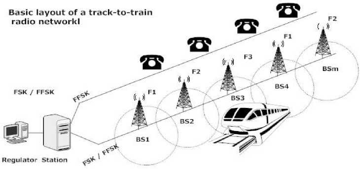
Fig. 1: Basic layout of a track-to-train radio network
This sequence is carried out so that the frequencies may be reused and to avoid interference among them; that is, when reusing f1, the previous BS signal with the same frequency is minimum and is mixed up with the environmental noise and will not be considered by MS.
The MS will be recorded at the several BS along the line scanning the three frequencies and selecting the one receiving the highest level signal. There are four groups of frequencies allocated to Rede Ferroviária Nacional, EP (REFER—responsible for the Egyptian Railway Infrastructure) by the Egypt Communications Authority.
The existence of four groups of frequencies is due to the fact that railways in Portugal are interconnected at certain points of the country.
A different group of frequencies is allocated to each line, so that those frequencies may be reused along the same line. At the interconnection points with other lines, the chosen group is that of the main line (by main line, we refer the lines that are principal in the national railways, that means the lines that connect the principal cities, the industrial zones, ports, etc.). The explanation, for the frequency group change, is related to the fact that if the interbase stations of the secondary line (secondary lines are the ones that are only used for lower traffic) had the same frequency group, the main line and secondary line signals would interfere with each other and the train would not be able to find out which interbase stations to register with. With the group frequency change, this problem no longer exists. Each regulation sector may only support up to 32 interbase stations due to the BS addressing. Several RS are installed at the CTC stations or local control stations. The function of the RS shall be to establish, control, and supervise all message traffic. The system comprises two base types of equipment:
-
• fixed equipment (RS, fixed station, and railway station);
-
• Mobile, portable, and movable equipment. In this system, there are three types of messages: telephony, status, and short data message (SDM).
The modulation used for the status messages is frequency shift keying (FSK) and fast frequency shift keying (FFSK). FSK subaudios at 50 Bd messages are continuously transmitted by fixed stations during the conversations and signal to mobile stations the fixed stations status. These messages are transmitted in sub audio band in order not to disturb the telephony message exchange, and their transmission rate is low due to the modem type used, which does not allow greater speeds. FSK messages at 1200 b/s are used for communications between fixed stations and RS via phone line (polling and traffic messages). FFSK messages at 1200 b/s are used in selective calls and status service between MS and RS. SDM, modulated in FFSK at 1200 b/s, have appeared by the need of providing the MS with a data channel at 1200 b/s, in order to interconnect information boards, ticket machines, and new features such as frequency groups automatic changes, sleeping mode, etc., in the future. A SDM message may support up to 96 characters within its data field. There are three types of SDM messages: 1) Normal: in the event of a message coming in during a conversation between driver and regulator, the latter will go into a wait mode at the base until the conversation ends; 2) Urgent or high priority: during a conversation between driver and regulator, the latter will override the conversation; and 3) and Reply Messages: inform the REFER computer about the transmission result of a SDM, e.g., Mobile answers, Mobile does not answer, Mobile registered, Base station Busy, Base station does not exist, SDM not sent, SDM sent, Error alive message.
-
IV. Mobile Station [9]
Mobile station is the name of the equipment installed at the locomotives and that guarantees the communication via radio, between the train and the RS of the regulation section where the latter is registered.
All these connections have to be carried out through the RS. Communications between the MS and the RS may be carried out through telephony or status messages. An MS (Figs. 3 and 4) comprises a BG550 CP-N control unit which serves as an interface with the operator [man machine interface (MMI)], a handset, a loudspeaker, an antenna, and a Tx/Rx subrack, which in turn comprises a SE550 CP-N transceiver, which is a Tx/Rx transceiver for the radio frequency (RF) communications, a data collection unit (ORD), a DC/DC converter, and one interface card with the passenger information system (AP).
The core of the whole system is an ORD universal interface that aims at the correct integration of different systems, translating protocols, data routing, or even equipment control. ORD carries out the interconnection between the transceiver and the mobile equipment being responsible for the interpretation and routing of the controls and data
-
V. Integration of the GSM Communication System
The GSM integration aims at solving the lack of communication between local controls stations/centralized traffic centers with MS, in lines where no track-to-train radio coverage exists, which means mainly on secondary lines where the development of a complete core communication system is extremely expensive. Thus, came the idea of integrating GSM in track-to-train radio, using one of the existing GSM network operators[10]. With this integration, the data transmission goes from 1200 to 9600 b/s. This alteration is carried out at the level of the rack components of the MS and at the time of the change due to a dual-mode antenna. In this case, the same interphone desk may be used and it is not
necessary to make new drillings or cable runs for this purpose. In short, this development is aimed:
-
• To provide MS the access to GSM public network, enabling direct interphone communication, between traction permanent and the driver;
-
• To increase the data transmission capacity (SMS) to a transmission rate from 1200 to 9600 b/s.
The GSM interphone works independently from the physical track-to-train radio network, but if during a GSM call, the regulator needs to communicate with the driver, this GSM call goes into a wait mode and will only be reconnected when the train-to-track radio connection is ended; that is, train-to-track prevails against GSM when it is present. This additional data transmission at 9600 b/s may be used at the Depot Management, which has some advantages over the solution foreseen for the train-to-track radio such as it is infrastructure-free and the speed rate is eight times greater. [11]
-
V I. Design Goals
The goal of the current research effort is to demonstrate a way to track Trains using automated technologies (GPS) and report their location automatically
-
• Monitoring and controlling train speed, through the speed provided by the GPS system, in tracks which are not equipped with the ATC system.
-
• Avoid the automatic alteration of maximum speeds allowed, in variable information beacons, as are the cases of slackening caused by track maintenance works or by occasional alterations in track conditions, which may subsequently cause accidents involving some physical and material damage
-
• Knowing the train location, Through the GPS system, we may transmit information data on a certain part of the track with running problems, for a control center, such as the weather information in steep slopes, where sometimes heavy freight trains are not able to climb or do it very slowly, causing great circulation delays. Also, the sending of surveillance information from driving cabs or train deposit parks may be very useful.
-
VII. Proposed Solutions
In this solution, the GPS-GSM/GPRS[12] module collects the position information of a train at every instant and passes this information to a web server shown in figure 6.1 and in figure 6.2. As data being passed to the web server containing a real IP address and now listen to a specific port assigned for it.
A database created at the server end stores these data.
The database now contains all the necessary information that it needs to update the position of any particular train.
A web page continuously communicates with the host server as requested. This web page contains a detailed map of a location. Here Google map is used to show the updates of location. As new data being inserted into the database, it updates the location information containing speed, distance from a particular station etc. of the train at the client end in this Google map. [13]
Traffic Flow Diagram of GPS based train monitoring system
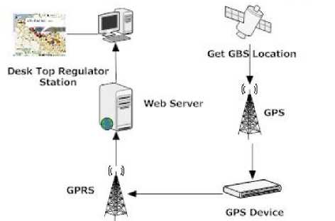
Fig. 6.1: Traffic flow diagram of GPS based train monitoring system
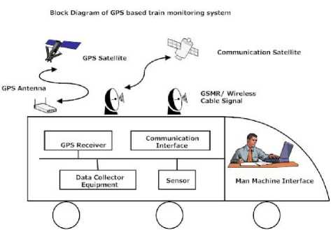
Fig. 6.2: Block Diagram of GPS train monitoring system
The man machine interface can also become a useful tool for preciously locating a train in a track. Every track available in our current railway system is assigned to a specific code number. This code number can individually represent the track position of a train. An operator in the train continuously updates the track number in the computer which is connected with the GPS-GPRS module. The data served by GPS and the onboard computer is accumulated by the server and the server is able to give accurate position with track number and makes the decision when and in which track the train should arrive at the next crossing. The central control room now has the total overview of every single train running all over the Egypt with their instant status.
The GSM/GPRS World Tracker AVL (hereafter referred to as “World Tracker AVL”) is an Automated Vehicle Locating (AVL) device that utilizes a GSM/GPRS modem and a Global Positioning Satellite (GPS) module. Working together, these technologies allow the World Tracker AVL to simultaneously act as a standalone GPS reporting device and wireless data retrieval unit. The World Tracker AVL provides a flexible AVL solution with Input/output (I/O), six selectable National Maritime Electronics Association (NMEA) GPS data format, Trimble ASCII Interface Protocol (TAIP) GPS data format, and Security Concepts’s own proprietary Binary GPS data format. The WorldTracker AVL is designed to work in a standalone device in an automobile. Security Concepts’ World Tracker AVL provides maximum AVL versatility in a single affordable device.
As we show in figure 6.1.1, the work flow of the hardware, after turning on the device, it automatically initializes the network. Then it gets the GPS data in NMEA 0183 (National Marine Electronics Association) [15] format and adds it with its own unique IMEI (International Mobile Equipment Identity) number. It then tries to connect to GPRS. If it fails due to GPRS unavailability then it logs the data in the non-volatile memory and waits for a certain fixed time period. After that it tries to connect to the GPRS
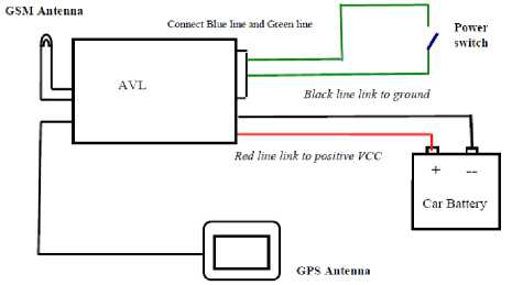
Fig. 6.1.1: General Diagram
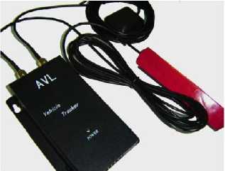
Fig. 6.1.1.1: AVL GPS-GPRS Module
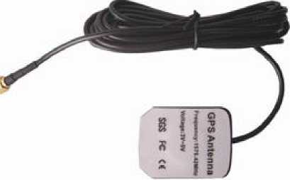
Fig. 6.1.1.2: GPS Antenna
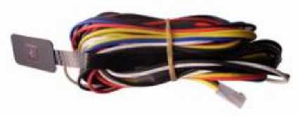
Fig. 6.1.1.3: Car Charger Lighter Socket
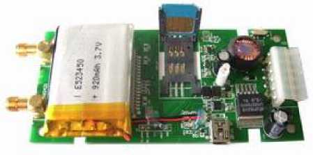
Fig. 6.1.1.4: SIM card connector
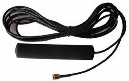
Fig. 6.1.1.4: GSM Antenna
After establishing the GPRS connection it tries to connect to the service provider’s server using the HTTP (Hypertext Transfer Protocol) protocol. After successful connection, the GPS device sends the data with id number.
-
6.2 Software Specification
To view the current position of the train a web-based application has been developed. Using this web application an end user is able to view the live position of the train and also the distance from a particular station in a Google Map. To implement this project PHP5 (Hypertext Preprocessor), HTML (Hyper Text Markup Language) [16], [17] and Ajax (Asynchronous Java script) scripting language was used. My SQL, [18] database server is used for storing data because of its high-performance query engine, tremendously fast data insert capability, and strong support for specialized web functions.
A TCP/IP (Transmission Control Protocol/ Internet Protocol) listener is responsible for accepting NMEA[19] data which is sent by the device via GPRS to a specific Port of the desired IP address. This data consists of the id number of the device. Each device can be assigned to a unique id no. The sever side flow diagram is shown in figure 6.1.2, Explains that when a GPS is set to work, it transmits its position in NMEA format to the server station. After listening the IP for new connection, it responds. Then new position is transmitted to the server in NMEA format. NMEA data consists of GPS identification no. If module id is verified, then data is transmitted. Now, server parses the NMEA data and extracts Latitude and Longitude and saves them to the database. [20]
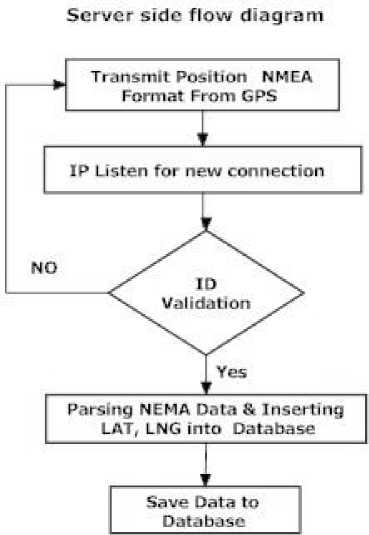
Fig. 6.1.2: Server side flow diagram
Ajax is asynchronous, to which extra data is requested from the server and loaded in the background without interfering the display and behavior of the existing page. Data is retrieved using the XML (Extensible Markup Language) Http ( Hypertext Transfer Protocol) request object that is available to scripting languages running in modern browsers, or, alternatively, through the use of Remote Scripting in browsers that do not support XML Http Request. Server Database stores all the position information. As illustrated in figure 6.1.3, when a client asks the position of a train an xml http request is generated and is transferred to the server. Then the server queries database for extracting the latest position information. Finally, the server sends this information to the client end and shows the updates in Google map.
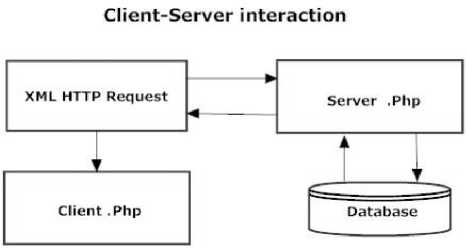
Fig. 6.1.3: Client-Server interaction
-
6.3 Research Recommendations and Important Attributes
This system is very cost effective. GPRS was used for data transfer instead of SMS (Short Message Service). Several SMS based vehicle tracking [21] systems are available in the local market which sends SMS with current position data when a request is made by SMS. This SMS based tracking System is neither efficient nor cost effective. In most countries the cost of GPRS is cheaper than SMS by a factor of 20 to 100 (SMS costs about 0.5-1.0 Taka/SMS whereas GPRS costs about 0.02 Taka/KB). This system firstly reduces the manpower required and secondly reduces train accident, one train accident leads to loss of huge money, which can be saved and be used by government for modernization of railways and also late running of trains can be prevented to large extend.
In the present railway system, it is not possible to locate and monitor the status of all trains on a single moment. But, now in the implemented satellite based train monitoring system, it is possible to locate every locomotive and show the positions of these locomotives on a single monitor within an instant. As the control room has the full access in the system, the controller now has a clear understanding about the current situation of the system in a moment. Besides, as this system works along with the onboard computer held on the locomotive, the operator now also have clear view about its own position and the track on which it is moving.
Watched and monitored by parents (speed limit exceeding, leaving a specific area), as well as for human and pet tracking.
-
IX. Analysis of Results
Using our simulation environment, we evaluate the performance of GPS tracking as a function of the “penetration level”, which is the percentage of all trains who are instrumented with our Smartphone application. The main results from our simulation efforts are shown in Figure 7.1. As the penetration level rises, the amount of time spent waiting for the train at the Trains stop, or “wait time” is reduced. The reported wait time is the number of minutes spent at the Trains stop, if you arrived at the stop when either the schedule or the tracking system said the Train would arrive. Specifically, for a Train that is real-time tracked all the way to the stop, we report a “wait time” of 90 seconds, a reasonable safety margin. The motivation behind this interpretation of wait time is that users are likely to adapt their travel behavior when they have real time information, and plan to arrive at the stop with little or no margin. Similar gains could be achieved without real-time tracking, but only if Trains always arrived on time.
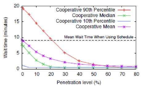
Fig. 7.1: Wait time vs. Penetration level using Cooperative Train Tracking with fallback on schedule sharply even at low levels of penetration, and that at 20% penetration level, the median wait time is essentially zero.
In Figure 7.2, we show the wait times for only those users that were able to take advantage of cooperative transit tracking data. This illustrates how the quality of our arrival time predictions improve as the penetration level rises. Here, every request is served using cooperative transit tracking data, but the quality of the arrival time prediction depends on when the location of the Train was last reported.
Finally, Fig. 18 shows the proportion of requests served using cooperative transit tracking data as a function of the penetration level. The proportion rises steeply up to the 20% penetration level, where more than 83% of requests are served. Intuitively, above the 20% level the vast majority of vehicles either already has an instrumented train aboard, or had one aboard quite recently. These results are particularly encouraging in the context of trains, where a relatively small number of vehicles serve a very large number of users.
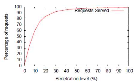
Fig. 7.3: Requests served vs. Penetration level
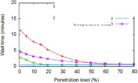
Fig. 7.2: Wait time vs. Penetration level using Cooperative Train Tracking Only
Cooperative 90th Percentile —+—
Cooperative Median —*—
Cooperative 10th Percentile
Cooperative Mean
In 7.1, the system falls back on the schedule when no real time tracking is available. Thus, at the 0% penetration level, performance is identical to simply using the schedule (and arriving two minutes early). Conversely, at 100% penetration, performance is essentially identical to an officially installed transit tracking system. We note the median wait time drops
-
X. Conclusion
Railway has long been considered as the safest transportation media. To improve the efficiency of the transportation systems, it is necessary to investigate the accidents and find out the essential methodologies for optimum management of information and resources available in railway rescue operations. The statistics shows that a huge number of accidents occurred due to human errors. Therefore, having a systematic way for railway operation management and reduction of human intervention, controlling activities, performances etc. may play a significant role to diminish the number and impact of accidents. Moreover, Reliable, accurate, precise, up-to-date and structured geospatial data is the key for decision making. Therefore, this system is very essential for Egyptian railway because it could bring an abrupt change to the existing train monitoring system.
In this paper, a new system that is able not only to communicate with train but also to locate it with a great precision in real time, both inside and outside tunnels, has been described. The solution presented here allows the immediate deployment of communication and tracking train systems with a minimum cost both in infrastructure and in maintenance. Thus is a viable solution to be used in secondary lines, where the available budget is limited.
That is why the contributions on this paper allow the deployment of an integrated system that simultaneously includes a radio communication system and a location solution in low-budget railways. The proposed network works as a redundant system when the traditional radio and tracking systems are available, but it will also work on secondary lines where no other system is available.
If we look at the fact that the overall system uses the train exclusively, then no infrastructure is really needed, cutting the deployment time and cost. Moreover, a low-budget system to track the trains inside tunnels was also presented again with a minimum infrastructure deployment.
Acknowledgments
References A Proposed Model for Radio Frequency Systems to Tracking Trains via GPS(The Study for Egyptian National Railways)
- H. Hofestadt, “GSM-R: Global system for mobile radio communications for railways,” in Int. Conf. Electric Railways in a United Europe, Amsterdam, The Netherlands, Mar. 1995, pp. 111–115.
- M. Leach, Ed., Train Control Systems. London, U.K.: Institute of Railway Signalling Engineers (IRSE), A&C Black, 1993.
- M. Ikeda, “Characteristic of position detection and method of position correction by rotating axle,” Q. Rep. RTRI Jpn., vol. 34, no. 4, pp. 270–276, 1993.
- Track to Train Communications System. Monte de Caparica, Portugal: NEC Portugal, 2000
- G. A. Bates, “Use of GPS in a mobile data acquisition system,” in IEEE Colloq. Dev. Use GPS Power Syst., London, U.K., Feb. 1994, pp. 2/1–2/3.
- Egypt railway, available at: http://en.wikipedia.org/wiki/Egyptian_National_Railways
- R. Mazl and L. Preucil, “Sensor data fusion for inertial navigation of trains in GPS-dark areas,” in IEEE Intelligent Vehicles Symp. 2003 - Proc., vol. 1, Piscataway, NJ, Jun. 2003, pp. 345–350.
- J. B.-Y. Tsui, Fundamentals of Global Positioning System Receivers: A Software Approach. New York: Wiley, 2000.
- A. J. D. Santos and N. B. Carvalhol / Tracking Trains via Radio Frequency Systems, IEEE TRANSACTIONS ON INTELLIGENT TRANSPORTATION SYSTEMS, VOL. 6, NO. 2, JUNE 200
- S. M. Redl, GSM and Personal Communications Handbook. Boston, MA: Artech House, 1998.
- C. Drane, Positioning Systems in Intelligent Transportation Systems. Boston, MA: Artech House, 1997.
- W. Tomasi, “Advanced Electronics Communi-cations Systems”, Sixth edition, page-629.
- E. D. Kaplan, Understanding GPS—Principles and Applications. Boston, MA: Artech House, 1996.
- N. K. Das, C. K. Das, Rajesh Mozumder, and Jiban Chandra Bhowmik /Satellite Based Train Monitoring System , Journal of Electrical Engineering The Institution of Engineers, Bangladesh Vol. EE 36, No. II, December 2009
- Association, National Marine Electronics. NMEA 0183 Standard, available at: http://www.nmea.org/pub/0183/index.html
- Grameen Phone Internet, available at: http://www.grameenphone.com/index.php?id=134
- PHP Documentation, available at: http:// www.php.net
- MySQL AB. MySQL Documentation, available at: http://dev.mysql.com/doc/
- S. Fararooy, J. Allan, J. Jin, K. Maleki, and F. Pang, “Accurate train localisation in open space and tunnels,” in Int. Conf. Public Transport Electronic Systems (Conf. Publ. No. 425), London, U.K., May 1996, pp. 25–29.
- J. Tisal, The GSM Network: GPRS Evolution: One Step Towards UMTS. Chichester, U.K.: Wiley, 2001.
- Al-Bayari and O. B. Sadoun, “New centralized automatic vehicle location communications software system under GIS environment,” Int. J. Comm. Syst., Wiley, Apr., 2005. Available at: http:// www.interscience.wiley.com.
