Archaeological sites as markers of hydrosystem transformation in the Kurai and Chuya basins, Southeastern Altai, in the late Pleistocene and Holocene. Summary of findings and paleogeographic reconstructions

Author: Agatova A.R., Nepop R.K., Slyusarenko I.Y.
Journal: Archaeology, Ethnology & Anthropology of Eurasia @journal-aeae-en
Section: Paleoenvironment, the stone age
Article in issue: 1 т.45, 2017.
Free access
Short address: https://sciup.org/145145294
IDR: 145145294 | DOI: 10.17746/1563-0110.2017.45.1.025-035
Text of the article Archaeological sites as markers of hydrosystem transformation in the Kurai and Chuya basins, Southeastern Altai, in the late Pleistocene and Holocene. Summary of findings and paleogeographic reconstructions
Landscapes forming under the influence of geological structure, relief, climate, hydrosystem, soil cover, and biocenosis have always affected the existence of humans as a biological species. These factors determine their ranges of distribution, their ways of life, the dynamics of their social processes, their religions, and the territorial organization of their societies. In turn, archaeological sites can serve as markers of ecosystem transformation.
The southeastern part of the Altai Mountains (the Russian territory of the Altaian upland, the south Siberian mountains) was populated as early as the Late Paleolithic (Derevianko, Markin, 1987). An arid climate, a wide distribution of permafrost rocks, and an extremely low density of population facilitate preservation of the rich archaeological heritage of this region, which was one of the centers of ancient civilizations, and was located at the intersection of trade, military, and migration routes between the East and the West.
In 2016, we commenced a series of publications devoted to the analysis of new data on the relationships between man and environment in the highlands of southeastern Altai. In these studies, we assess the impact of climatic changes (as evidenced by processes of glaciation and deglaciation), the emergence of icedammed and residual lakes, soil- and peat-formation, and seismic activity, on the succession of sedentary and nomadic cultures; and on the ranges of distribution of these cultures in the Kurai and Chuya depressions during the Late Pleistocene and Holocene. In the first article (Agatova, Nepop, Slyusarenko et al., 2016), we discussed the issues of the existence of the Holocene lake basins closely related to the evolution of the Late Pleistocene glacio-lacustrine system within the Kurai and Chuya intermountain areas. This paper summarizes geochronological data on the evolution of Late Pleistocene ice-dammed lakes and Holocene residual lacustrine systems, taking into account our new findings based on comprehensive geomorphological, geoarchaeological, and geochronological studies.
The use of the geoarchaeological approach is based on the idea that unfavorable factors have a much greater impact in determining the distribution-range of people than favorable living environments have. The latter may not be fully utilized, either because of low population density, or for socio-economic reasons. Thus, confinement of in situ archaeological sites to certain forms of relief and landscapes generally points to favorable conditions for their development by people. This allows analysis of the locations of sites attributable to various cultures to be employed in assessing parameters of water reservoirs in the basins at various time-slices; the time and character of their emptying; and also the ages (terminus ante quem) of terraces and proluvial cones in the main Chuya valley.
This paper discusses the possibility of using Paleolithic sites in order to date the emptying of the last Chuya icedammed lake in the Late Pleistocene; and archaeological localities from the Late Bronze Age to the Middle Ages, in order to reconstruct hydrological changes in the Chuya and Kurai basins in the Holocene. The analysis conducted points to the need for a thorough study of the occurrence and spatial arrangement of the sites, so as to use them as arguments for or against a particular view of the chronology and character of natural processes.
Archaeological sites of the Kurai-Chuya system of basins
The bottom of the Chuya basin lies in the range 1750 to 2000 m a.s.l., while that of the Kurai basin is at 1500 to 1650 m a.s.l. The framing ridges reach an elevation of 3900–4300 m a.s.l. and represent one of the present-day glaciation centers of Altai. The basins are separated by the Chagan-Uzun massif, an independent tectonic block characterized by high seismotectonic activity during the Late Pleistocene and Holocene. The existence of archaeological cultures in the Kurai and Chuya basins is directly related to the climate-responsive evolution, in the Late Pleistocene and Holocene, of the hydrological system of these depressions.
The most ancient sites, which were dated to the Late Paleolithic (45–10 ka BP) by their techno-typological characteristics, have been identified in the Chuya depression, where 20 localities of stone tools are currently known (Derevianko, Markin, 1987; Okishev, Borodavko, 2001; Slavinsky et al., 2011). Notably, no archaeological objects belonging to the period between the Paleolithic and the Bronze Age have been found either within the Kurai-Chuya system and its mountain framing, or in the adjacent areas of Altai and Tuva. The majority of southeastern Altai sites are attributed to the Bronze Age (late 4th–early 1st millennium BC), Scythian (late 9th–3rd centuries BC), Xiongnu (2nd century BC–the first half of the 5th century AD), and Old Turkic (late 5th–11th centuries AD) epochs. Sites of the Kyrgyz period (the second half of the 9th–11th centuries AD) and the Mongolian (12th– 14th centuries AD) are much rarer. During the Kyrgyz Khaganate and the Mongol Empire, Altai was located on their periphery, and was not even mentioned in historical chronicles. There are no archaeological or written sources containing information on the population of southeastern Altai in the 15th–16th centuries AD (Molodin, 2002; Epokha…, 2006; Tishkin, 2007).
In the territory under consideration, Pazyryk sites of the Scythian epoch, for which bulk radiocarbon and dendrochronological dates were obtained, are best studied in terms of absolute dating (Evraziya…, 2005; Panyushkina et al., 2007; Slyusarenko, 2010). A series of 14C-dates are available for archaeological sites of the Xiongnu and Turkic epochs (Kubarev V.D., Zhuravleva, 1986; Kubarev G.V., 2005: 139; Orlova, 1995; Kubarev G.V., Orlova, 2006; Panyushkina et al., 2007; Gutak, Rusanov, 2013; Agatova, Nepop, Bronnikova et al., 2016), and there is a single date for the Afanasievo burial ground of the Bronze Age (Stepanova, 2009). The sites of Kyrgyz and Mongolian periods within the Kurai and Chuya basins and their mountain framing are not characterized by absolute dates.
At present, the eastern and southern parts of the Chuya basin, where a huge number of sites belonging to various cultures are concentrated, are the best-studied (Kubarev V.D., 1987, 1991, 1992; Bourgeois et al., 2000, Gheyle, 2009; and others). A number of objects in the Kurai depression have been described, including Pazyryk mounds of the Scythian period (Kubarev V.D., Shulga, 2007: 170–190), Bulan-Koba burials of the Xiongnu epoch (Soenov, Ebel, 1998; Soenov, 2003: 13–22; Slyusarenko, Bogdanov, Soenov, 2008), and mounds attributed to the Kyrgyz period (Martynov, Kulemzin, Martynova, 1985). In the Chuya River valley, between depressions, archaeological localities are known in the mouth of the Kuektanar (Kuyakhtenar) River: Late Paleolithic surface-finds (Derevianko, Markin, 1987: 11–12), iron-smelting furnaces dated to the 6th–10th centuries by their typological characteristics (Zinyakov, 1988: 46–49), and Kyrgyz artifacts interpreted as traces of settlement (Hudiakov, 1990). Mapping of a number of archaeological sites in the central part of the Chuya basin, in the east of the Kurai basin, and in the Chuya valley between them (including the mouth of the Kuektanar) was carried out in the course of studying the evolution of Holocene limnosystems in this area (Agatova, Nepop, Bronnikova et al., 2016; Agatova, Nepop, Slyusarenko et al., 2016).
Evolution of the hydrosystem of the Kurai and Chuya basins in the Late Pleistocene and Holocene
Pre-Holocene period of hydrosystem development
Current views on the time of the last emptying of the Late Pleistocene ice-dammed lakes in the Kurai and Chuya basins. The chronology and character of the emptying of the Late Pleistocene lakes within the Kurai and Chuya intermountain basins determine the possibility of finding the most ancient archaeological sites in this territory. However, owing to the complexity of the chronometric dating of glacial and glaciolacustrine deposits, and the inconsistency of the dates obtained by various methods, there is no consensus so far on the age of the glaciations and the chronology of the emptying of the ice-dammed lakes. Radiocarbon dates used for age characterization of lakes in the basins are obtained mainly from charcoal fragments (>45,000 cal BP (Beta-147107) (Okishev, Borodavko, 2001), 30,000 ± 1112 cal BP (25,300 ± 600 (MGU-IOAN-65)) (Razrez…, 1978: 130)); or from organic remains in wave-built and catafluvial deposits (36,588 ± 883 cal BP (32,190 ± 260 (Beta-137035)) (Okishev, Borodavko, 2001), 40,820 ± 1100 (35,870 ± 490 (Beta-159972)) (Herget, 2005: 36), 24,814 ± 610 (20,750 ± 220 (SOAN-4971) ((Vysotsky, 2009) and 39,851.5 ± 1101.5 cal BP (34,750 ± 480 (SOAN-7802)), the date was provided by A.N. Nazarov), which suggests possible erosion and redeposition of more ancient organic remains*. It has not been until recently that OSL-dates of immediate lacustrine deposits in the Kurai basin have been obtained. These dates demonstrate repeated emergence of various ice-dammed lakes in the Late Pleistocene, such as 62,500 ± 6800, 18,200 ± 1100 (Baryshnikov et al., 2015: 106, 112), and 14,400 ± 1400 BP (RIS0-142565) (Zolnikov et al., 2016). According to the results of dating using cosmogenic nuclides (10Be) of boulders in the Chuya and Kurai depressions, the last desiccation of these depressions, which was the most disastrous, took place about 16–15 ka BP (the breakup time of the Sartan (Late Würm) glaciation) (Reuther et al., 2006). A.N. Rudoy also considers the lake-emptying related to the Sartan glaciation to have been the most disastrous. Relying on radiocarbon dates of plant remains from lacustrine deposits in the frost-mounds on the bottoms of basins (Rudoy, 1988; Butvilovsky, 1993), he substantiates the final desiccation of the Kurai and Chuya basins as occurring later than approximately 11 and 5 ka BP, respectively (Rudoy, 2005: 128–129). P.A. Okishev and P.S. Borodavko (2001) reconstruct three limno-stadials in the period of 46 to 13 ka BP from the results of radiocarbon (Razrez…, 1978; Butvilovsky, 1993; Okishev, Borodavko, 2001) and thermoluminescent (Sheinkman, 1990) dating, and propose that isolated lakes existed in the depressions during the last of them. According to these researchers, gradual (non-disastrous) level-recession of the Pleistocene lakes determines the chronology of the Paleolithic sites in the Chuya basin. The idea that the last disastrous floods in the Chuya and Katun valleys were of Sartan (Late Würm, 18–25 ka BP) age has lead G.Y. Baryshnikov and A.M. Maloletko to the conclusion that a search for archaeological objects older than 25 ka BP along the valleys of the main Altai rivers is pointless; and that such finds will only be encountered beyond the limits of disastrous water flows (1998: 114). Later, OSL dating has allowed clarification of the time of the debris-flow passage across the upper Biya River valley, which proved to be more ancient: 35–40 ka BP (Baryshnikov, Panin, Adamiec, 2016). In contrast, I.D. Zolnikov and A.A. Mistryukov attribute the last disastrous emptying of the lake that existed in the Chuya valley to the Late Würm (70–60 ka BP), using the Paleolithic sites found here as one of the chronological benchmarks (2008: 52–53).
In general, it is exactly the poor availability of chronometric data and, as a consequence, the complexity of reconstructing the Late Pleistocene geological history of southeastern Altai, that force the geologists to refer to archaeological materials. However, to avoid mistakes in paleogeographical constructions, areal locations of sites and the character of their occurrence should be subjected to detailed analysis in each particular case.
The possibility of using Paleolithic sites of the Chuya basin to date the emptying of Late Pleistocene ice-dammed lakes. When ancient archaeological sites of southeastern Altai are used as chronomarkers, the central problem is the absence of numerical evaluations of their ages. Pointing to a certain techno-typological heterogeneity of Chuya lithic industries, A.P. Derevianko and S.V. Markin attribute these to the Late Paleolithic (45–10 ka BP) (1987: 46–54), and this circumstance seems to close the discussion of the existence of the disastrous emptying of the icedammed lakes in the Chuya and Kurai basins at the end of the Late Pleistocene. At the same time, 3 of 20 Late Paleolithic sites identified in the Chuya basin (Ibid.; Okishev, Borodavko, 2001; Slavinsky et al., 2011) have not been characterized at all, owing to isolated finds, and only four of them stratified (Yustyd I and II, Boguty I, Toldytyurgun). Furthermore, absolute dating of the layers accommodating artifacts was not conducted. It must be especially emphasized that all stratified sites suitable for dating, including those comprising the most ancient artifacts showing the Levallois reduction technique, are located higher than 2100 m a.s.l., the upper paleolacustrine level, which is the most pronounced in relief. The majority of the other sites are below 2100 m a.s.l., and all of them are represented by surface finds (Fig. 1), sometimes with obvious traces of downhill shifting (Torgun) or exposure to a water environment (Barburgazy). The Kuyakhtenar locality in the Chuya River valley (1725– 1730 m a.s.l.) is the lowest of them. No trend has been observed in the distribution of the few surface finds (28 spec.) concentrated on the surface of a 10–11-meter terrace among sand dunes (Derevianko, Markin, 1987: 11–12). The Kuyakhtanar-2 site, where surface finds include five lithic artifacts, has been discovered not far from this place, on sand dunes as well (Slavinsky et al., 2011: 469). Radiocarbon dating of paleosols and fluvio-lacustrine deposits conducted by the authors in the area of the Paleolithic finds (Agatova, Nepop, Slyusarenko et al., 2016: Fig. 2, 3, tab. 1) implies that formation of the cover subaerial complex did not start until the Holocene, and that fluctuations of the Chuya bed and active erosion of ancient lacustrine sediments took place during the last third of the Holocene, which indicates a highly probable redeposition of stone material. Partial redeposition of artifacts on the stratified site of Yustyd II was also noted by Derevianko and Markin (1987: 36). The discovery of “Upper Paleolithic-like stone tools (end-scrapers)”, along with remains of grasses and branches aged 5453 ± 391 cal BP (4765 ± ± 120 (SOAN-2345) (Rusanov, Orlova, 2013: 146– 149)) in deposits of Lake Dzhangyskol (the Kurai basin) by V.V. Butvilovsky, also confirms a high probability for redeposition of Paleolithic artifacts in intermountain areas and valleys of ridges. In our opinion, in view of the above, it would be inappropriate to use the majority of Paleolithic sites in the Chuya basin for direct dating of the existence of the last large ice-dammed lake therein. At the same time, a number of characteristics of the Bigdon site, the most representative in terms of collected materials and the area of their spread, point to a post-lacustrine or “inter-lacustrine” time for its existence.
Bigdon is located at an elevation of 1998 m a.s.l. near the southern foot of the Kurai ridge, on a flattened surface of proluvial cone separated from the ridge by a parallel graben-like depression. The ancient inhabitants of the Chuya basin did not use bedrocks (as indicated in the article by Derevianko and Markin (1987: 16–17)), but dropstones, i.e. blocks brought to the depression by icebergs during the existence of one of the Late Pleistocene lakes with a level not lower than 2000 m a.s.l. (Fig. 2, B, C). Such numerous fields of dropstones along the southern foot of the Kurai ridge in the Chuya basin have been described by G.G. Rusanov (2008). The Chechketerek Paleolithic site is attributed to another field of this type. The discovery of more than 750 items made of the same rock in the immediate vicinity of the blocks (Derevianko, Markin, 1987: 18)
Paleopeat
Kosh-Agachi
'Mukhor-Tarkhata
Tobeler
Kokorya
b
Tashanta
g
d
e
/ /SOAN-1645 / / 12,596 t 137 5
/ Wood in lacustrine
/ deposits „—■
(jtc-8470 Г
15,473 ±475 ) .
20 km
< IGAN-4098 \13,786±166
•y Paleopeat
Aktash
SOAN-9086 8791 ±200
Paleosol
SOAN-2378 9717 ±177
SOAN-8903 8223±181
Paleosol
SOAN-9094 9861 ±324
f
Paleosol
Charcoal in lacustrine deposits
а
c
h
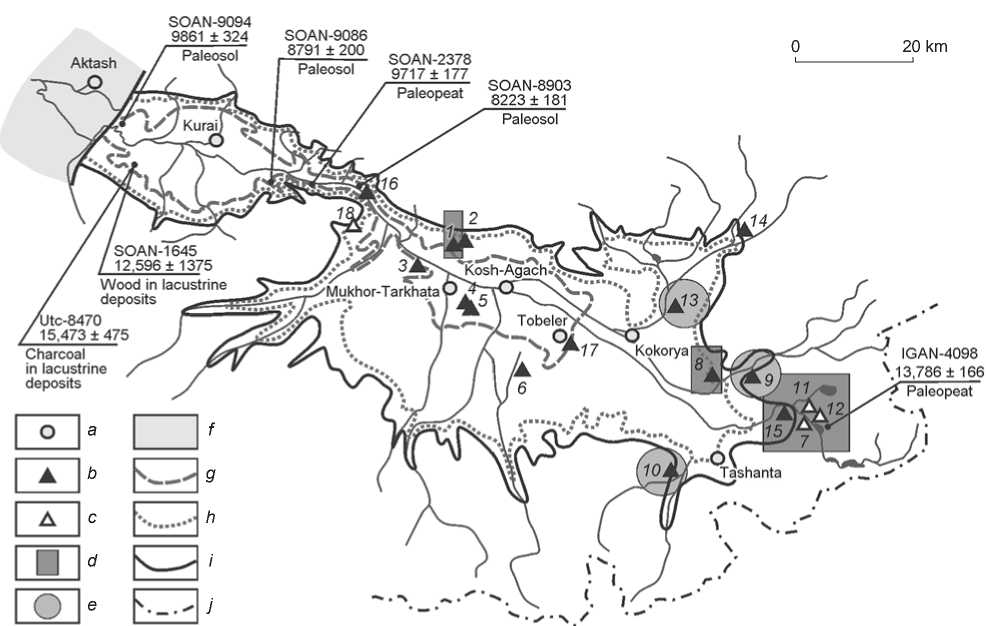
Fig. 1. Relation between the Late Paleolithic sites and the levels of paleolakes in the Kurai-Chuya system of basins, and basic radiocarbon dates (calibrated at σ) characterizing the development of landscapes in these basins at the end of the Late Pleistocene and in the Early Holocene.
a – settlements; b – localities of surface finds; c – stratified objects; d – localities with Levallois flakes; e – non-characterized localities with single artifacts; f – ice dam; g–i – level of paleolake a.s.l.: g – 1800 m, h – 2100 m, i – 2250 m; j – state border of Russia.
Localities: 1 – Bigdon; 2 – Chechketerek; 3 – Torgun; 4 – Mukhor-Tarkhata I; 5 – Mukhor-Tarkhata II; 6 – Chaganburgazy; 7 – Boguty I; 8 – Barburgazy; 9 – Yustyd-Barburgazy; 10 – Ulandryk; 11 – Yustyd I; 12 – Yustyd II; 13 – Kyzyl-Shin; 14 – Maltalu; 15 – Yustyd – left bank; 16 – Kuyakhtenar; 17 – Ters-Akan; 18 – Toldytyurgun. 1–17 – after: (Derevianko, Markin, 1987); 18 – after: (Okishev, Borodavko, 2001).
indicates the in situ location of the Bigdon site and its functioning after the emptying of a unified Kurai-Chuya lake, across which icebergs moved, or after the recession of its level below 1998 m. The Bigdon upland is formed by lacustrine wave-built terraces (Fig. 2, A); however, it is difficult to determine at this point whether they emerged before or after the existence of this archaeological site. Derevianko and Markin point to a certain “blownness” of the faces of tools (Ibid.: 18); however, establishing exactly wind-blown rather than water treatment of artifacts requires a special analysis. The location of the site, at an elevation of approx. 2000 m, is not exclusive of the synchronous or subsequent existence of an ice-dammed lake with a lower level.
In general, despite the signs of redeposition of many Paleolithic materials to lower hypsometric levels, even their present-day location (up to 1770 m a.s.l. at Mukhor-Tarkhata I) does not rule out the possibility that a lake with a level below 1770 m a.s.l. existed in the Chuya basin at the end of the Late Pleistocene to the beginning of the Holocene.
Therefore, despite the numerous Paleolithic sites, these cannot be used for determining the time of emptying of ice-dammed lakes with levels up to 2100 m (which is well pronounced in the relief of the Kurai and Chuya basins at the wave-built level), because of the surface character of the stone material lying below this mark, the probable redeposition of most of the finds, and the complexity of their absolute dating. All four stratified sites of the Chuya basin are located higher than 2100 m a.s.l.; so, they can serve only as markers of the existence and emptying of the deeper lakes proposed by some researchers. In this case, however, it is necessary to solve the issue of the possible redeposition of artifacts.
Evolution of the hydrosystem in the Kurai and Chuya basins. The accumulated geological data allow the identification of the main boundaries of decrease in Sartan glaciation in southeastern Altai, and of the
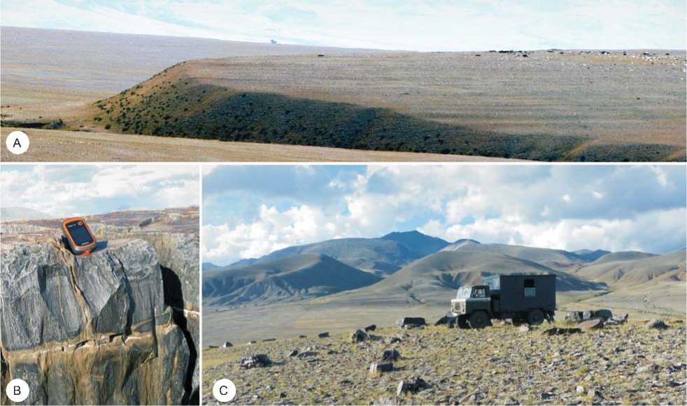
Fig. 2. Late Paleolithic site of Bigdon.
A – lake terraces simulating the surface of piedmont proluvial cone where the site is located; B, C – dropstones (as can be seen clearly in photograph B, the fragments are not the products of destruction of bed-rocks, which do not crop out in this part of the Chuya basin).
existence of the related dammed lakes (Fig. 1). The results of radiocarbon dating of charcoal from deposits at Lake Dzhangyskol, and from an adjacent bog in the Eshtykkel locality of the Kurai basin, are indicative of the absence of Sartan glaciers at the foot of the Northern Chuya Ridge (1754 m a.s.l.) 15 ka BP (13,050 ± 150 (Utc 8470) (Blyakharchuk et al., 2008)). The radiocarbon date of 13,786 ± 166 cal BP obtained by us for the peat horizon overlying the moraines in the Boguty River valley (the Chikhachev ridge) (11,910 ± 70 (IGAN-4098)) unambiguously indicates that they retreated above 2500 m a.s.l. in the eastern framing of the Chuya basin before 14 ka BP (Agatova, Nepop, Bronnikova et al., 2016; Agatova, Nepop, Slyusarenko et al., 2016). Thus, the reconstruction of extensive glaciation of southeastern Altai for the time-slice of approx. 14 ka BP, based on assessments of snowline depression (Rudoy, 1995), is, in our opinion, inconsistent with this time boundary.
By that time, in all likelihood, the lower ice-dam in the western part of the Kurai basin, near the mouth of the Maashey River (at about 1460 m a.s.l.), did not exist either. Such conclusions are compatible with the results of cosmogenic isotope dating of dropstone boulders in both depressions that indicate desiccation of them about
16–15 ka BP (Reuther et al., 2006)*. The discovery of wood in the deposits of Lake Dzhangyskol (10,960 ± ± 550 (SOAN-1645) by V.A. Panychev (Rusanov, Orlova, 2013: 142)) suggests growth of forest vegetation along the southern periphery of the Kurai basin at an elevation of not lower than 1754 m as early as about 12,596 ± 1375 cal BP. A considerable degradation by the beginning of the Holocene of the glaciers in southeastern Altai, and the adjacent region of western Tuva, is indicated by discovery of paleowood aged 11,347 ± 470 cal BP (9880 ± 115 (SOAN-8753)) above the modern forest boundary in the Katun Ridge at 2600 m a.s.l. (the date is provided by A.N. Nazarov), and aged 10,380 ± 200 cal BP (8900 ± 95 (SOAN-8116)) in the Mongun-Taiga mountain group at 2640 m a.s.l. (Nazarov, Solomina, Myglan, 2012). The destruction of the ice dam near the mouth of the Maashey River, and full desiccation of the Kurai basin even before the Holocene, are most clearly evidenced by the date of paleosol on the surface of the talus cone formed after emptying of the lake in the Chuya valley 3.5 km above the dam location at an elevation of 1470 m. This paleosol is dated to 9861 ± 324 cal BP (8770 ± 140 (SOAN-9094)) (Fig. 1) (Agatova, Nepop, Slyusarenko et al., 2016: Fig. 4)).
The second dam (ice and then landslide-moraine) was formed in the Chuya valley at the mouth of the Kuektanar River, in an area between the basins. An abrasion level of 1800 m a.s.l. is well pronounced above and below the dam along the valley. The Sukor landslide, on the left bank of the overlying moraine of the Kuektanar glacier, is eroded, and also terraced to an elevation of 1800 m. These facts point to the formation, and partial erosion (up to 1750–1760 m a.s.l.), of the landslide-moraine dam even before the emptying of the lake, the initial level of which was not lower than 1800 m a.s.l. Apparently, at that time, it was unified for both basins, was impounded near the mouth of the Maashey River, and existed in the pre-Holocene period (the collapse of the giant Sukor landslide at the end of the Late Pleistocene was proposed by Butvilovsky as well (1993: 164)). A similar conclusion about a later destruction of the Maashey ice-dam at the final stage of glaciation was drawn after studying sections of glacial deposits in the Kuektanar area (Zolnikov, Mistryukov, 2008: 66). The wide occurrence of lacustrine sediments along with Late Pleistocene-Holocene ostracod fauna in the Chuya basin in the range of elevations from 1760 to 1800 m a.s.l. (Rusanov, 2010) does not conflict with this conclusion (though Rusanov himself believes that the lake that left these remains in the Chuya basin was impounded by a dam in the mouth of the Kuektanar, and that this dam was partially eroded only in the subboreal period of the Holocene). Judging by the composition of single palynomorphs and redeposited pollen of Neogene vegetation, the lacustrine deposits overlying a moraine below the mouth of the Kuektanar River (Agatova, Nepop, Slyusarenko et al., 2016: Fig. 3) were accumulated in the Late Pleistocene*. The pre-Holocene time of disastrous flood passage across the Chuya valley that resulted in the formation of a large-boulder pack in the upper part of a 15-meter terrace in the mouth of the Sukhoi stream is evidenced by the radiocarbon dates of overlying sediments of a small landslide-dammed lake: 9717 ± 177 and 8308 ± 110 cal BP (8700 ± 65 (SOAN-2378), 7530 ± 60 (SOAN-2379)) (Butvilovsky, 1993: 165).
Development of hydrosystem in the Holocene
First half of the Holocene. After the emptying of the ice-dammed lake, common for both basins, that occurred even before the Holocene and not later than 8 ka BP, the “Kuektanar dam” could have impounded the Chuya basin lake with the water surface no higher than 1750–1760 m a.s.l. (the crest height of the highest moraine line); but, apparently, lower, since the Chuya incision into the dam already existed, though it was not as high as it is today. By 8223 ± 181 cal BP (7440 ± 95 (SOAN-8903) (Agatova, Nepop, Bronnikova et al., 2016)), soil had been formed at the surface of lacustrine deposits overlying the moraine at an elevation of 1730 m (Butvilovsky attributes this paleosol horizon to 7452 ± 133 and 6131 ± 150 cal BP 6565 ± 80 (SOAN-1692B), 5330 ± 80 (SOAN-1692C) (1993: 208)). Thus, as early as 8 ka BP, only a local morainedammed lake with the water’s edge below 1800 m a.s.l. (which is lower than the bottom of the Chuya basin) could have existed in the mouth of the Kuektanar River. No traces of any other dam capable, as supposed by Rusanov (2010), of impounding a lake with a level of 1800 m a.s.l. up to the subboreal period of the Holocene (4500–2500 BP) have been established by us here (though a later destruction of such a dam is not impossible). Obviously, after the emptying of the unified Kurai-Chuya lake, several relatively vast water reservoirs with a thermophilic Late Pleistocene-Holocene ostracod fauna could have been preserved in local depressions of the Chuya basin within this level. Marls, aleurites, and clays rich in calcium carbonate, characterized by this fauna, lie in the central part of the depression, near the Ortolyk, Kosh-Agach, and Tobeler villages (Devyatkin, 1965; Butvilovsky, 1993: 168; Rusanov, 2010).
Radiocarbon dates of paleosols at the base and at the top of clastic sediments accumulated in the water environment near the slope foot of the Chuya valley, below the mouth of the Baratal ravine (western part of the Kurai basin) (Agatova, Nepop, Slyusarenko et al., 2016: Fig. 4) allow us to state that 10,000– 6500 BP a water reservoir with a level not lower than 1480 m a.s.l. existed again in the Kurai depression—at least in its western part. The dam could barely have been of ice, since no later than 7000 BP, forest vegetation was restored apically in the trough within mountain framing of the basins, and glaciers no longer exceeded their present-day size; or, possibly, degraded fully (Nazarov, Solomina, Myglan, 2012; Agatova et al., 2012).
About 8700 BP, the level of the lake in the Kurai depression (or possibly, a system of lakes) could not have been higher than 1720 m a.s.l., and the lake did not enter into the Kurai basin, which is evidenced by our radiocarbon date (SOAN-9086) of the lowest of the paleosols overlying alluvial-proluvial sediments in the Arydzhan River valley at this elevation (Agatova, Nepop, Bronnikova et al., 2016). Information is available about the same age of the terrace level of 1610 m a.s.l. in the northern part of the Kurai depression (Carling et al., 2011).
Thus, in the first half of the Holocene, lacustrine systems of the Kurai and Chuya basins developed actually in isolation, being connected only by the Chuya River. By the time of the erection of the Borotal-1 group of Pazyryk mounds (Kubarev V.D., Shulga, 2007: 180–185), the position of its bed near the mouth of the Baratal River was already close to the modern one (Agatova, Nepop, Slyusarenko et al., 2016). Despite the softer climate of southeastern Altai in the first half of the Holocene, as compared to that of our day (Butvilovsky, 1993; Blyakharchuk et al., 2008; Agatova et al., 2012; Agatova, Nepop, Bronnikova et al., 2016; Nazarov, Solomina, Myglan, 2012), no archaeological sites dated to this period are known in the Chuya and Kurai depressions. In our opinion, their absence may be due to a wide distribution of residual lakes on the bottoms of those basins at that time.
Second half of the Holocene. The evolution of the residual lakes on the bottom of the Chuya basin in the second half of the Holocene is characterized by three radiocarbon dates of lacustrine and alluvial deposits, and by in situ location of archaeological sites. The results of radiocarbon dating of buried male bones from Afanasievo burial ground Tarkhata I, located 16 km southeast of the Mukhor-Tarkhata village (Mukhor-Tarkhata I after: (Larin, Mogilnikov, Surazakov, 1994)*) (4514 ± 270 cal BP (3985 ± 60 (SOAN-6028) (Stepanova, 2009)), confirm that the water level in the basin could not have been higher than 1927 m a.s.l. at that time. According to Rudoy (1988), the age of plant-remains (leaves, stems, twigs) in the lacustrine deposits from a depth of 0.6 m exposed in a frost mound near the Tobeler village, at an elevation of about 1780 m, 4174 ± 270 cal BP (3810 ± 105 (SOAN-2106)), indicates that the ice-dammed lake no longer existed in the Chuya basin at that time. Rusanov (2010) treated this date as the time of accumulation of the upper pack of deposits in the lake impounded by already partially eroded landslide-moraine dam in the mouth of the Kuektanar River. In our opinion, the date may characterize lacustrine sedimentation in one of the local water reservoirs in the central part of the basin, since the “Kuektanar dam”, by that time, had stopped fulfilling its role long ago. The location of rock fills attributed to the Late Bronze Age–the beginning of the Early Iron Age near the Mukhor-Tarkhata village (Agatova, Nepop, Slyusarenko et al., 2016) gives unambiguous evidence that at the time of their formation (approx. 3 ka BP), the water-level in the center of the depression no longer exceeded 1770 m a.s.l. In the Scythian epoch, it could not have been higher than 1764 m a.s.l. at this place, as confirmed by the erection of Pazyryk mounds. The location of similar sites at the same elevation in the western part of the Chuya basin, and formation of a paleosol horizon at an elevation of 1951 m on the Yustyd River floodplain about 2150 ± 146 cal BP (2130 ± 25 (SOAN-8423)), are indicative of the local character of the lakes that existed in the depression.
Later than 1437 ± 270 cal BP (1540 ± 40 (SOAN-7412)), deposition of clays, with ostracods usual for shallow waters with unstable depths (including the stratigraphically significant species Candona stagnalis typical of the Holocene) started 3.5 km southeast of Kosh-Agach, at an elevation of approx. 1764 m. In section, they replace lacustrine sands having Late Pleistocene-Holocene ostracod fauna that characterizes first several meters of the water body depths (Rusanov, 2010). At the same time, in the 6th–7th centuries, as confirmed by radiocarbon dates 1480 ± 62, 1402 ± 106, 1337 ± 51 cal BP (1610 ± 10 (АА-69267), 1474 ± 40 (АА-69265), 1425 ± 40 (АА-69264) (Panyushkina et al., 2007)), 1425 ± 113 cal BP (1535 ± 60 (SOAN-5919) (Kubarev G.V., Orlova, 2006)), Old Turkic population expanded into the lower areas of the Chuya basin down to an elevation of 1753 m a.s.l. (funerary enclosures in the Chagan-Uzun River valley). The body of presented data can be interpreted as recession of level and breakup of still sufficiently large lakes, with preservation, up until now, of their relics in the local lows of the depression. However, it is not improbable that a series of shallow water reservoirs were formed on the basin’s bottom later than 1500 BP, after the desiccation period, the duration of which can barely be estimated as yet. Nevertheless, despite the ambiguous interpretation of geological data, the presence of lacustrine deposits in a considerable area suggests that the basin could not have been fully developed by nomads during the lacustrine stage of the evolution of its landscapes.
The non-disastrous character of the probable desiccation or recession of the level of the Chuya depression lakes during the period between the Scythian and Turkic epochs follows from the location of both Pazyryk and Old Turkic sites on the Chuya River terraces, and on proluvial cones of its tributaries at a distance of no more than 200–1000 m from the bed in the Chuya graben and in the Kurai basin. This also points to a pre-Scythian time of possible disastrous floods (Agatova et al., 2014; Agatova, Nepop, Bronnikova et al., 2016). The emptying of the local lake in the mouth of the Kuektanar occurred no later than the construction of iron-smelting furnaces here (6th–10th centuries), wherein charcoal aged 1696 ± 122 cal BP (1775 ± 35 (SOAN-5040) (Gutak, Rusanov, 2013)) and 1152 ± 143 BP (1250 ± 65 (SOAN-9091) (Agatova, Nepop, Slyusarenko et al., 2016)) was used, i.e. long before the Mongolian earthquake of 1761. Consequently, it could not have caused the emptying of this lake, as was proposed by E.A. Rogozhin and S.G. Platonova (2002: 107).
After the breakup of the lacustrine system, the river network remained mobile. Migrations of river-bed, and periodic floods, have been recorded in the sediments of the mouths of Tydtuyaryk (Schlütz, Lehmkuhl, 2007), Kuektanar, and Sokpanda rivers (Agatova, Nepop, Slyusarenko et al., 2016: Fig. 2, 3). Exactly in the zone affected by floods and re-winnowing of sandy deposits, surface finds of the Late Paleolithic (Derevianko, Markin, 1987: 11) and artifacts of the Kyrgyz culture have been discovered (Hudiakov, 1990), in the vicinity of the mouth of the Kuektanar River. The almost complete destruction of the iron-smelting furnaces indicates a high rate of retreat of the Chuya’s right bank since their construction.
Desiccation and fluctuations of the level of residual lakes determined changes of microclimate in the depressions, and entailed reduction of the local erosion basis and transformation of fluvio-lacustrine system: formation of the Chuya River bed connecting the residual lakes, incision of its tributary beds and formation of their mouths within the bottoms of basins, deflation of exposed lacustrine deposits, pedogenesis, and colonization by vegetation. These processes could have influenced the ranges of distribution of nomadic peoples, their economic cycle and diet, and caused new communications to be established. The subsequent appearance of permanent settlements (Chagan-Uzun, Ortolyk, Kosh-Agach, and others) on the bottoms of Chuya and Kurai depressions became possible only because of the desiccation of basins as well. It cannot be excluded that the names of some of them ( ortolyk means “island” in the Turkic language) are reminiscent of the times when nomads needed not only horses, but also boats to move across the depressions.
Conclusions
The upper time-boundary of the emptying of the ice-dammed lakes in the Kurai and Chuya basins of southeastern Altai cannot be unambiguously assessed now, because of the lack of absolute dates for the Paleolithic sites and the wide range of their possible existence, their probable redeposition, and the surface character of most finds. The use of products of iceberg transportation as cores suggests a post-lacustrine (or “inter-lacustrine”) age for the Bigdon and Chechketerek Late Paleolithic sites in the Chuya depression.
New radiocarbon dates give an idea of a substantial decrease of the Sartan glaciation before 14 ka cal BP, and the emptying of the last ice-dammed lakes within the Kurai and Chuya basins in the pre-Holocene period (before 10 ka cal BP). The absence of Early Holocene archaeological sites in those depressions may be due to a wide distribution of residual lakes on the bottoms of the basins at that time; however, the landslidemoraine dam in the mouth of the Kuektanar River did not impound the lakes in the Chuya basin as early as 8 ka BP. In the second half of the Holocene, starting from the Late Bronze Age, hydrosystem transformation proceeded without disastrous consequences for humans; however, it determined the areas suitable for their habitat.
In general, using archaeological sites has introduced considerable clarity into reconstructions of the changes in the limnosystems of the Kurai and Chuya basins, which were previously based on geological data alone.
Acknowledgements
The authors are grateful to A.N. Nazarov (Siberian Federal University, Krasnoyarsk) for providing two unpublished radiocarbon dates, and to K.N. Solodovnikov and N.N. Seregin (Altai State University, Barnaul) for their help in searching for the necessary information on a number of archaeological sites.
