
Classification of Landscape Facies Types (Based on the Example of the Sheki–Zagatala Region of Azerbaijan)
Journal: Bulletin of Science and Practice @bulletennauki
Section: Естественные науки
Article in issue: 9 т.12, 2026.
Free access
This study provides a comprehensive classification of elementary landscape units (facies) distributed along the southern slope of the Greater Caucasus in the Sheki–Zagatala region, based on their lithological-geomorphological, hydrological, biological, and biogeochemical characteristics. The research analyzes the morphology of river valleys extending from the Mazimchay to the Vandamchay rivers, the orientation of tectonic fractures, and the impact of slope-driven microclimatic variations on biogeochemical processes. To determine the regular distribution of chemical elements in soils and silt layers, V. V. Kovalsky's biogeochemical methodology was applied, classifying local soils into five geochemical groups and relying on B. B. Polynov’s foundational theory of elementary landscapes. As a result, 14 major landscape-facies types were identified within the 500–2000 m elevation range, corresponding to mountainous, temperate semi-humid, and semi-arid sloping plain landscapes. Among these, six belong to the eluvial group, three to the superaquatic group, three to the subaquatic group, and two to the deluvial group. Regional landscape-geochemical analyses reveal that intensive leaching in high-altitude eluvial systems causes significant thinning of the humus horizon and depletion of nitrogen and potassium, accelerating desertification trends over carbonate-rich substrates. Conversely, in subaquatic and aqua-accumulative (waterlogging-prone) facies, hydromorphic conditions significantly retard organic matter decomposition, facilitating the thickening of the fertile humus layer and resulting in the substantial accumulation of nitrogen, phosphorus, and potassium.
Short address: https://sciup.org/14139006
IDS: 14139006 | UDC: 504.54 | DOI: 10.33619/2414-2948/130/10
Классификация типов ландшафтных фаций (на примере Шеки-Закатальского региона Азербайджана)
Представлена развернутая классификация элементарных ландшафтных единиц (фаций), распространенных на южном склоне Большого Кавказа (Шеки-Закатальский регион), на основе их литолого-геоморфологических, гидрологических, биологических и биогеохимических особенностей. В ходе исследования проанализированы морфология речных долин в пределах гидрографической сети от реки Мазимчай до реки Вандамчай, направление тектонических разломов и влияние микроклиматических различий склонов на биогеохимические процессы. Для выявления закономерностей распределения химических элементов в почвах и иловых отложениях была применена биогеохимическая методология В.В. Ковальского, в соответствии с которой почвы региона были разделены на 5 геохимических групп; теоретической базой анализа послужило учение об элементарных ландшафтах Б.Б. Полынова. В результате в высотном диапазоне 500–2000 м, охватывающем горные, умеренно полувлажные и полуаридные ландшафты наклонных равнин, было выделено 14 основных типов ландшафтных фаций. Из них 6 отнесены к элювиальной группе, 3 — к супераквальной, 3 — к субаквальной и 2 — к делювиальной группе. Региональные ландшафтно-геохимические исследования показали, что в высокогорных элювиальных условиях из-за интенсивного вымывания происходит уменьшение мощности гумусового горизонта, а содержание азота (N) и калия (K) падает до минимума, что усиливает тенденции опустынивания на карбонатных породах. Напротив, в субаквальных и аквально-аккумулятивных (склонных к заболачиванию) фациях гидроморфные условия замедляют разложение органического вещества, способствуя утолщению плодородного гумусового слоя и значительному накоплению азота (N), фосфора (P) и калия (K).
Text of the scientific article Classification of Landscape Facies Types (Based on the Example of the Sheki–Zagatala Region of Azerbaijan)
Бюллетень науки и практики / Bulletin of Science and Practice
UDC 504.54
The development of landscape science is impossible without considering the natural components of a territory, including relief conditions, vegetation cover, soil types, surface and groundwater resources, climatic conditions, and anthropogenic impacts. Among these components, the lithological and geochemical composition of rocks associated with the most recent geological foundation also plays a significant role. To determine the developmental trends of landscapes, it is necessary to consider the genetic homogeneity of the geological structure underlying natural territorial complexes. The simplest elementary landscapes are formed upon the geological foundation and its boundaries and are characterized by similar relief and climatic indicators. These characteristics, in turn, create conditions for the regular formation of the biological component system of landscapes, including soils, vegetation cover, and fauna [4].
The major relief forms observed within the study area have been shaped by river-valley systems extending from the Mazimchay River to the Vandamchay River. According to their morphology and structure, these river valleys are classified into four groups. One group includes narrow gorge-like valleys with very steep slopes. Such valleys are observed in the upper reaches of all mountain rivers of the Sheki–Zagatala region, extending from alpine meadows to the mountain forest landscape zone (above 1800–1900 m), predominantly within areas where Jurassic sedimentary rocks are distributed [7].
The second group of relief forms within the river valleys of the southern slope of the Greater Caucasus consists of narrow valleys. These valleys are mainly distributed within the middle and upper mountain forest belts. They are characterized by narrow valley floors and very steep slopes (exceeding 45°). This relief type is primarily typical of smaller tributaries within river systems.
Materials and Methods
River valleys located within the Sheki–Zagatala region are generally organized in two directions, longitudinal and transverse, in accordance with the tectonic structure of the area. Transverse river valleys have mainly developed along tectonic fault zones. These valleys, intersecting major tectonic fractures, have also determined the flow directions of rivers such as Balakanchay, Katekhchay, Kurmukchay, Shinchay, Kishchay, Dashagilchay, Demiraparanchay, and Vandamchay.
Longitudinal river valleys, on the other hand, have primarily formed along tectonic uplift zones and mainly include tributaries of major rivers (for example, Hamamchay, the left tributary of Kurmukchay, and Chukhadurmazchay in the Kishchay basin).
Due to the orientation of tectonic fractures and the alternation of soft and hard rocks within the lithological composition of the geological formations, the left tributaries of the major river valleys on the southern slope generally flow from northeast to southwest, whereas the right tributaries flow from west to southeast.
Local landscape facies on the southern slope of the Greater Caucasus are formed as a result of increasing relief inclination, which creates microclimatic differences between opposing slopes. In this region, relief forms, solar radiation distribution, and the biogeochemical characteristics of soils are considered primary factors influencing biodiversity due to microclimatic variations [18].
Based on geomorphological differences, the climate of the Sheki–Zagatala region is classified into four groups [5, 6]: (1) mountainous, (2) plain, (3) humid, and (4) arid climate groups. Three types of mountain climate are observed in this region: humid, dry, and nival. The plain climate type includes continental and semi-desert climates. Within the Sheki–Zagatala region, the humid climate category comprises boreal and temperate humid climates, whereas the arid category includes dry and subtropical climates.
Due to very intense erosion processes on the southern slope of the Greater Caucasus, the relief is highly dissected by numerous river valleys. From the Main Caucasus Range towards the south, in the direction of the Alazani–Aghichay valley, steep-sloped relief conditions have developed [9].
The Alazani–Aghichay intermontane depression is 15–20 km wide and extends from the low-mountain areas of the Greater Caucasus to the Dashuz low-mountain range in terms of elevation. This area is also referred to as the Alazani–Aghichay depression. Rivers flowing from the southern slope cut across this basin through transverse valleys before joining the Alazani or Aghichay river network. In many areas, alluvial and proluvial accumulation cones are clearly visible on the surface. In such environments, the formation of clay and aleurite deposits with differing characteristics depending on lithological composition is considered a regular process. These alluvial deposits have created conditions for the formation of soil layers with varying chemical compositions in areas along river channels, for example in the Talachay basin of the Zagatala region [13].
Mountain temperate semi-humid and mountain temperate semi-arid landscapes, despite the relatively limited distribution area of the latter, are considered among the most characteristic landscape types in the mountainous part of the southern slope of the Greater Caucasus [20].
Mountain temperate semi-humid landscapes are distributed almost everywhere along the southern slope of the Greater Caucasus at elevations from approximately 600 m to 1800 m and are characterized by a temperate warm and sufficiently humid climate [6]. Erosion–denudation and karst– denudation relief types are typical for these landscapes.
The distribution area of this landscape type is distinguished by a moderately warm and adequately humid climatic regime. Winter temperatures range from -2.5°C to 6.0°C, while summer temperatures vary between 19.0°C and 25.0°C. The mean annual temperature changes from 10–12°C at the lower boundary to 6–7°C at the upper boundary. Annual precipitation ranges from 500–600 mm to 900–1000 mm, with the majority falling during the warm period of the year. Moving from west to east, the continentality of the climate increases, while the humidity coefficient decreases from 1.2 to below 1.0 [17].
These conditions are considered highly favorable for the development of broad-leaved forests, where the tree cover is dominated mainly by oak species (Quercus robur and Quercus petraea), as well as beech, hornbeam, linden, ash, poplar, birch, elm, and other tree species. In some parts of the area, due to climatic aridization and deforestation, thorny shrub and meadow-type natural territorial complexes have developed. Brown mountain-forest soils and humus–carbonate soils (formed on limestone substrates) are characteristic of such vegetation cover [11].
During the implementation of biogeochemical studies, the method proposed by V. V. Kovalsky on the regular distribution of chemical elements in soils and silt layers was applied [12].
In particular, this methodology was used for six groups of natural–anthropogenic landscapes: 1. landscapes that have preserved their initial natural state; 2. weakly altered landscapes; 3. disturbed landscapes; 4. strongly disturbed or anthropogenic landscapes (degraded soils); 5. strongly transformed landscapes as a result of long-term inefficient use; 6. modified or cultural landscape complexes created by humans on the basis of natural factors [3, 10, 14б 17].
The geochemical properties of soil-forming rocks in areas where biogeochemical studies are conducted are of great importance. Using various landscape-scientific research data from the Caucasus region, attempts have been made to study climate–landscape zones, analyze relief characteristics within landscape belts, and determine the relationship between landforms and soil types [1, 2].
The same methods have also been applied to investigate the chemical composition and biogeochemical cycling characteristics of dominant plant species distributed across the climate– landscape zones of the region. In our study, soil types distributed in different areas of the Sheki– Zagatala region were classified into five groups based on landscape–geochemical conditions [19], color and mechanical composition, as well as landscape characteristics: 1. dark-brown or brown soils; 2. brown soils; 3. light-brown soils; 4. brown-grey soils; 5. grey soils. [14, 17, 19]:
Results and Discussion
Silts are soft sedimentary rocks that mainly consist of a granular mass formed from the deposition of weathered mineral and organic matter, primarily composed of particles smaller than 0.01 mm (clay-sized fraction) [16].
Although they are generally water-saturated and soft, they may gradually lithify and become cemented over time. In the Sheki–Zagatala region, various types of silts are widely distributed in the more arid parts of the area, including terrigenous, calcareous, carbonate, pelitic (clayey), aleuritic, and clay–aleurite mixtures [17].
Microorganisms within silts tend to form spatially separated aggregates, while the large specific surface area of silts facilitates intensive interaction between microorganisms and the external environment. Silts rich in silica are mainly derived from alluvial clays accumulated in open geomorphological systems, whereas closed-system silts composed of kaolinite- and potassium-bearing clays are enriched in trace elements such as Fe, Co, Ni, Cu, Zn, and others, forming biogeochemically active silt environments [8].
The first classification of landscape facies was proposed by B.B. Polynov, who distinguished three main types of facies and defined them as elementary landscapes: alluvial, terrestrial (superaquatic), and subaquatic facies [19].
In the present study, based on the lithological–geomorphological, hydrological, biological, and geochemical characteristics of landscape facies distributed along the southern slope of the Greater Caucasus in Azerbaijan, 14 facies types were identified. Of these, 6 belong to the alluvial group, 3 to the superaquatic group, 3 to the subaquatic group, and 2 to the deluvial landscape-facies group. These facies are mainly distributed within the 500–2000 m elevation belt, corresponding to mountainous temperate semi-humid and semi-arid sloping plain landscapes [15].
Below, figures illustrating the elementary landscape–facies types characteristic of the Sheki– Zagatala region located on the southern slope of the Greater Caucasus within Azerbaijan are presented. Eluvial–accumulative landscapes, predominantly distributed in depressions characterized by good drainage conditions and deep groundwater occurrence, are dominant in the study area. In certain cases, atmospheric waters may interact with groundwater systems. Transported solid materials tend to accumulate within such landscapes. Different relief units are characterized by the occurrence of low-mountain forests, forest–shrub complexes, meadow, steppe, foothill meadow–steppe, shrubland, and forest–steppe landscapes.
The article identifies trends of desertification and waterlogging in fertile soils and presents indicators of landscape enrichment and depletion in chemical elements.
-
I. Eluvial Facies Group. This facies group is mainly distributed in elevated relief areas or watershed zones, where leaching processes predominate due to their topographic position.
Alluvial–Eluvial–Accumulative Facies Type
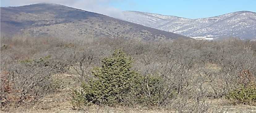
Figure 1. Sheki District, Sheki–Oghuz Highway, Azerbaijan
Mountain temperate semi-arid sloping plain landscapes are distributed within the elevation range of 500–800 m above sea level. Due to calcium (Ca) enrichment in the soils of these landscapes, intensive leaching processes lead to the thinning of the humus layer, while depletion of potassium (K) is also observed.
Eluvial–Denudational Facies Type
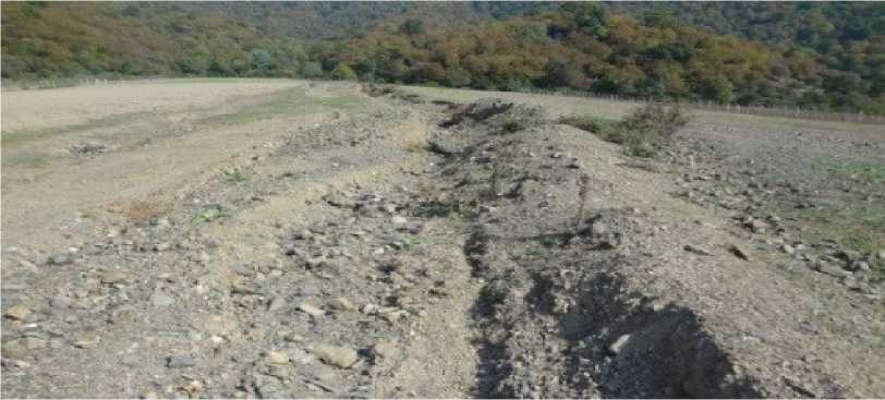
Figure 2. Southern slope of the Greater Caucasus, Postbina village, Balakan District, Azerbaijan

Mountain temperate semi-arid sloping plain landscapes are distributed within the elevation range of 500–800 m. This area is dominated by carbonate rocks and shows a tendency toward desertification processes. Soils in these landscapes are characterized by calcium (Ca) enrichment and carbon (C) depletion; in other words, intensive leaching leads to the thinning of the humus horizon. Under eluvial conditions, nitrogen (N) and potassium (K), as easily leachable elements, reach minimal concentrations. Although phosphorus (P) is relatively more stable, in carbonate-rich environments (areas with high Ca content) it is transformed into forms that are less available for plant uptake.
Denudational–Accumulative Facies Type
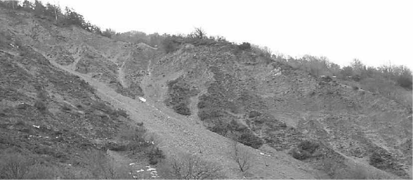
Figure 3. Southern slope of the Greater Caucasus, Gakh District, Azerbaijan
Mountain temperate semi-humid valley landscapes are distributed within the elevation range of 1200–1800 m. In the soils of these landscapes, intensive leaching leads to calcium (Ca) enrichment, thinning of the humus horizon, and depletion of magnesium (Mg).
Trans-eluvial Facies Type
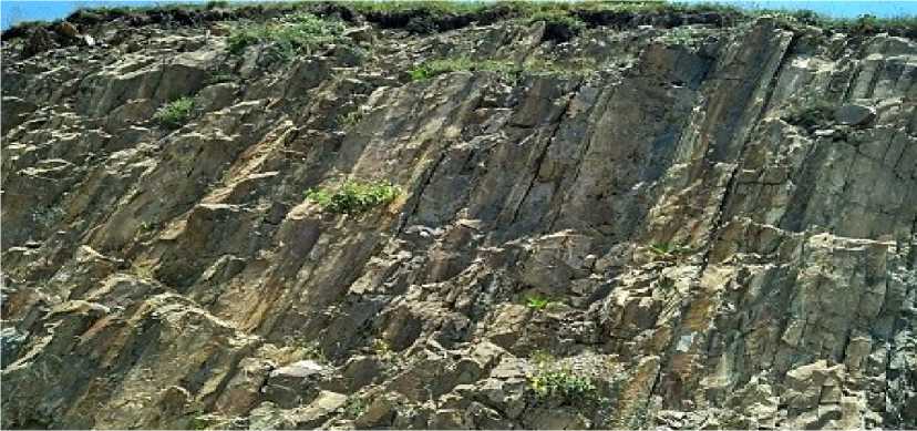
Figure 4. Southern slope of the Greater Caucasus, Khan Yaylag, Sheki District, Azerbaijan
Mountain temperate semi-humid landscapes are distributed within the elevation range of 1800– 2000 m. In trans-eluvial facies, mechanical migration processes dominate; therefore, the content of humus and nitrogen varies depending on slope steepness. On steep slopes, surface leaching of potassium (K) and phosphorus (P) is observed. Soils in these landscapes are characterized by calcium (Ca) enrichment, intensive leaching of the humus layer, and sodium (Na) depletion. Nitrogen (N) and potassium (K), being easily leachable elements, reach minimal concentrations. Although phosphorus (P) is relatively stable, in carbonate-rich environments (areas with high Ca content) it is transformed into forms that are less available for plant uptake.
Autonomic–Alluvial Facies Type
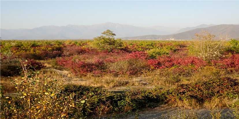
Figure 5. Southern slope of the Greater Caucasus, Sheki–Oghuz highway, Sheki District, Azerbaijan
Mountain temperate semi-arid landscapes are distributed within the elevation range of 600–800 m. Steppe-ified mountain steppe landscapes, accompanied by fragmented juniper shrub formations, dominate the area. Due to the high limestone content, this region shows a tendency toward desertification processes. In these soils, manganese (Mn) enrichment and potassium (K) depletion are observed.
Autonomous–Denudational Facies Type
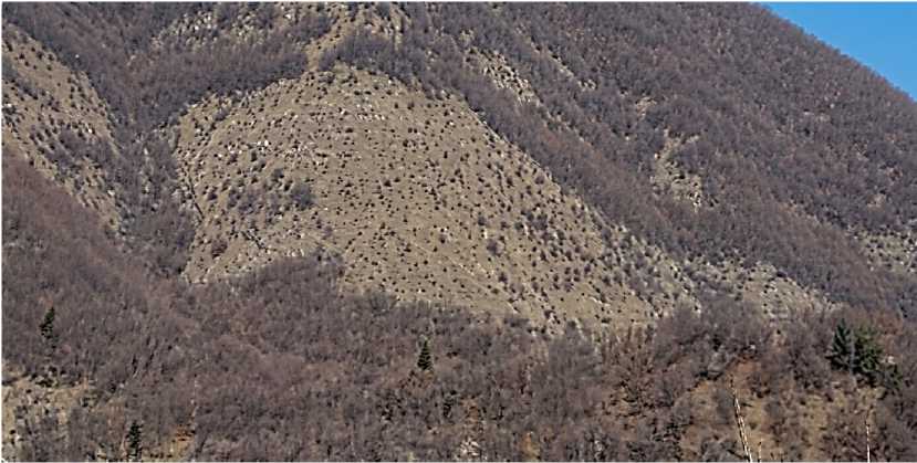
Figure 6. Southern slope of the Greater Caucasus, Gokhmug village, Sheki District, Azerbaijan.
Mountain temperate semi-arid landscapes are distributed within the elevation range of 600–
1300 m. Steppe-ified mountain steppe landscapes, accompanied by fragmented oak–hornbeam shrub formations, dominate the area. Due to the high limestone content, this region is prone to desertification processes. Soils are characterized by calcium (Ca) and sodium (Na) enrichment, while intensive leaching leads to the thinning of the humus horizon. Nitrogen (N) and potassium (K) are readily leached, whereas phosphorus (P), although relatively stable, occurs in forms that are less available for plant uptake under carbonate-rich conditions.
-
II. Subaquatic Facies Group. Low-relief, waterlogging-prone areas with alluvial fans, such as the Balakanchay and Ayrichay basins, can be considered geochemical barriers.
Trans-accumulative Facies Type
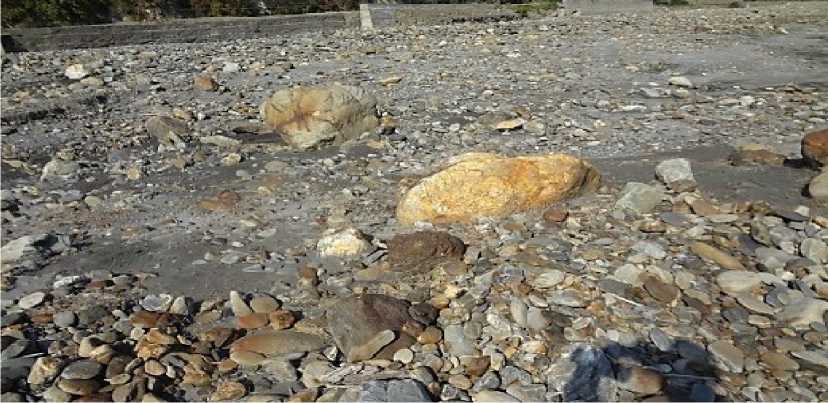
Figure 7. Southern slope of the Greater Caucasus, Balakan District, alluvial fan of the Balakanchay River
Mountain temperate semi-humid landscapes are distributed within the elevation range of 500– 800 m. This area is dominated by clay-rich deposits and shows a tendency toward waterlogging processes. In subaquatic and aqua-accumulative facies, hydromorphic conditions slow down the decomposition of organic matter, leading to the thickening of the humus horizon and the accumulation of nitrogen (N) and phosphorus (P) in this zone. These soils are characterized by calcium (Ca) enrichment and iron (Fe) depletion.
Erosional–Accumulative Facies Type
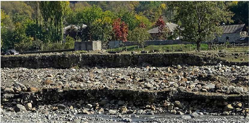
Figure 8. Southern slope of the Greater Caucasus, Solban village, Balakan District, Balakanchay River
Mountain temperate semi-humid landscapes are distributed within the elevation range of 600– 800 m. Erosional–accumulative relief is characteristic of these areas. Compared to zonal landscapes, this climatic zone is distinguished by relatively higher temperatures and increased precipitation. Soils in this area are characterized by potassium (K) enrichment and iron (Fe) depletion.
Erosion–Denudational Facies Type
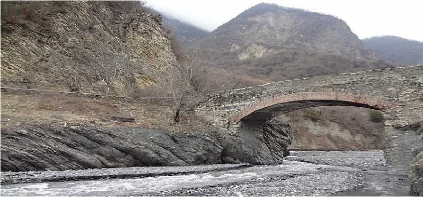
Figure 9. Southern slope of the Greater Caucasus, Ilisu Bridge, and alluvial fans of the Kurmukchay River, Gakh District, Azerbaijan
Mountain temperate semi-humid landscapes are distributed within the elevation range of 1200– 1300 m. These soils are characterized by calcium (Ca) enrichment and iron (Fe) depletion.
-
III. Subaquatic Facies Group.
Aquatic Facies Type
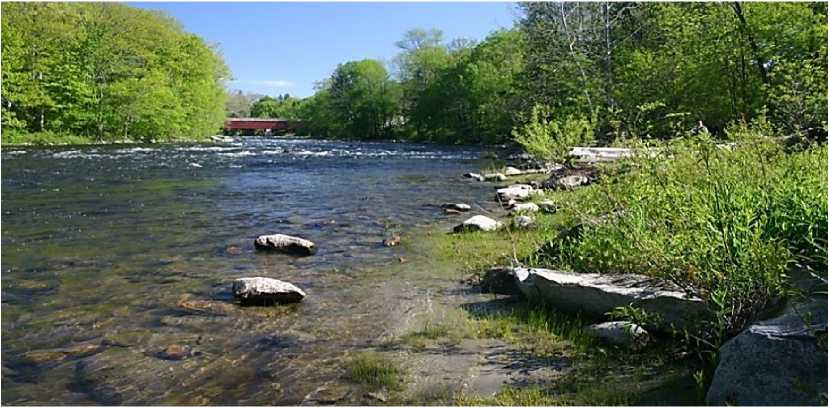
Figure 10. Southern slope of the Greater Caucasus, Ayrichay River, Sheki District, Azerbaijan
This area is dominated by clay-rich materials and is prone to waterlogging processes. Soils in this region are characterized by carbon (C) enrichment and calcium (Ca) depletion. In subaquatic and aqua-accumulative facies, hydromorphic conditions slow down the decomposition of organic matter, leading to the thickening of the humus horizon and the accumulation of nitrogen (N) and phosphorus (P) in this zone.
Transeluvial-transaquatic facies type.
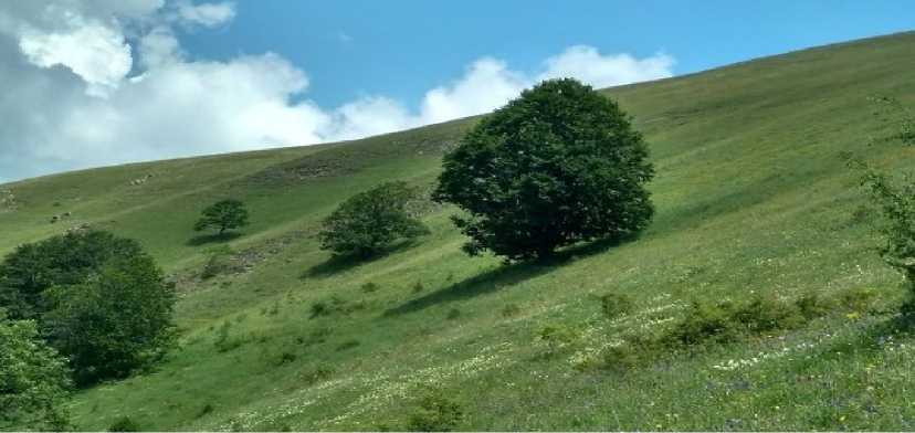
Figure 11. The southern slope of the Greater Caucasus. Khan Yaylag, Sheki district
Mountainous temperate semi-humid landscapes are distributed within the altitude range of 1800–2000 m. Enrichment with Mg (magnesium) and depletion of K (potassium) are observed in these soils.
Aquatic-accumulative facies type.
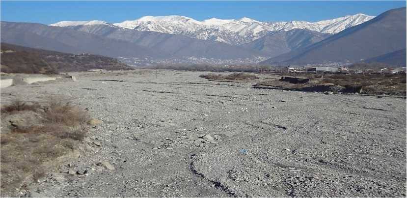
Figure 12. The southern slope of the Greater Caucasus, Sheki district. Alluvial fans of the Kish River
Mountainous temperate semi-arid landscapes are distributed within the altitude range of 500– 800 m. Enrichment with Ca (calcium) and depletion of Fe (iron) are observed in these soils. Due to the predominance of the leaching regime, the humus content is low (2–3%) in the facies formed by eluvial-denudation processes and accumulated in floodplains; furthermore, the process of nitrogen and potassium loss (depletion) is rapid.
-
IV. Deluvial facies group. These facies are primarily the transport zones of weathered materials on the terraces of the Kurmukhchay (Kurmukh River) basin.
Deluvial-accumulative facies type.
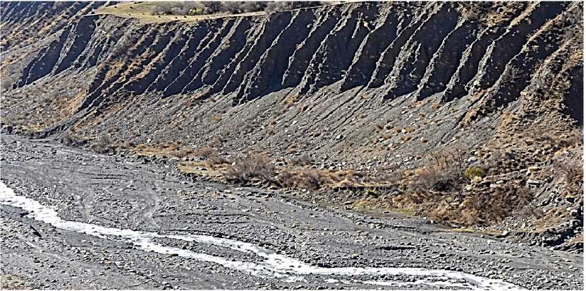
Figure 13. The southern slope of the Greater Caucasus. Qakh district, the Kurmukhchay (Kurmukh River)
Mountainous temperate semi-humid landscapes are distributed within the altitude range of 1200–1300 m. Sandy-gravelly scree (debris) formations develop on the slopes of river terraces. Since mechanical migration predominates in deluvial facies, the content of humus and nitrogen varies depending on the slope steepness; surface leaching of K (potassium) and P (phosphorus) elements is recorded on steep slopes. Enrichment with Ca (calcium) and depletion of K (potassium) are observed in these soils.
Autonomous-deluvial facies type.
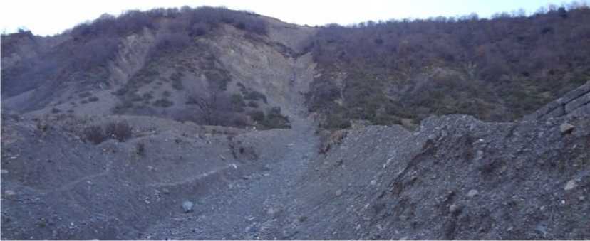
Figure 14. The southern slope of the Greater Caucasus. Qakh district, the Kurmukhchay (Kurmukh River)
Mountainous temperate semi-arid landscapes are distributed within the altitude range of 1200– 1300 m. Conglomerates are formed in the denudation valley along the Ilisu deep fault.
Due to the predominance of the leaching regime, the humus content is low (2–3%) in the eluvial-denudation acies, and the process of nitrogen and potassium loss (depletion) is rapid.
Since mechanical migration predominates in trans-eluvial facies, the content of humus and nitrogen varies depending on the slope steepness; surface leaching of K (potassium) and P (phosphorus) elements is recorded on steep slopes.
In subaquatic and aquatic-accumulative facies, hydromorphic conditions retard the decomposition of organic matter, which facilitates the thickening of the humus layer and the accumulation of nitrogen and phosphorus in this zone.
Conclusıon
Thus, in the high-altitude areas belonging to the eluvial landscape facies group of the Sheki-Zagatala region, a decrease in humus, nitrogen, and potassium occurs due to leaching. The phosphorus content is relatively low. In the trans-eluvial landscape group, the humus content is at a moderate level, nitrogen and potassium migrate through leaching, and the mechanical accumulation of phosphorus is observed. In the accumulative landscape facies of depressional areas, the contents of both humus and nitrogen, potassium, and phosphorus reach high levels for those territories.
