Creating database for HealthGIS application

Author: Sodoo Chadraabal , Kapil Oberai , Shiva Reddy
Article in issue: 1, 2015.
Free access
Nowadays web-based GIS is being increasingly utilized by health organizations and social health services to share and visualize geo-referenced health data through the Web. In the development of a public information and disease surveillance network, issues of providing information to people who really need it are important concerns. People should have instant access to the information of the health facilities by using internet connection from mobile and desktop devices. This will help them in saving time and will be economical to approach the facilities. Geographical Information system (GIS) and webGIS provides the tools for achieving all these things. This project work involves creating HealthGIS application database for CHSS (Contributory Health Service Scheme) of IIRS by using open source tools. This application will provide IIRS employees information related to the AMO/specialists, doctors, etc. hospitals/pathology labs under the CHSS panel and searching capabilities based on user location. The major objectives of this project are: Data collection: Collecting missing location data of specialist doctors, hospitals, pathology labs, etc. Organizing data about existing (from past project) CHSS beneficiaries, AMOs, hospitals, pathology labs, etc. in spatial database.
Gps, postgresql, postgis, qgis
Short address: https://sciup.org/148315906
IDR: 148315906 | UDC: 004.65
Создание базы данных для приложения HealthGIS
В настоящее время сетевая географическая информационная система все чаще используется организациями здравоохранения и различными сервисами, оказывающими социальные и медицинские услуги, эта система наглядно демонстрирует необходимость создания данных для здравоохранения в тесной связи с географическими данными. С развитием общественной информации и проблемами, возникающими в системе сетей наблюдения, очень актуальным становится вопрос предоставления информации людям, которые реально нуждаются в этом. У людей должен быть прямой доступ к информации о различных медицинских учреждениях и оборудованию при помощи выхода в интернет, через мобильный телефон и прочих устройств. Это поможет им экономить время, кроме того будет экономить транспортные расходы. Географическая информационная система (ГИС) и вэбГИС будут служить инструментом, способствующим достижению этой цели. Данный проект содержит в себе создание базы данных ГИС Здоровье для CHSS (Contributory Health Service Scheme) с использованием открытых источников. Это приложение будет обеспечивать сотрудников HRS информацией о специалистах, докторах и т.д. больниц, лабораторий, и на панели CHSS будет возможность поиска местоположения пользователя. Основные задачи проекта: Сбор данных Сбор недостающих данных о местоположении больниц, лабораторий, специалистов, докторов и т. д. Организация данных о существующих (из предыдущего проекта) CHSS больниц, лабораторий и т.д. в базе данных.
Text of the scientific article Creating database for HealthGIS application
Background
Nowadays computers have become the most important tool in many aspects of human life. People should have instant access to the information of the health facilities. Internet serves as the best means of providing such information which could be accessed via mobile or desktop devices. Such instant access to health GIS information will help users in saving time and money to reach the facilities. Geographical Information system (GIS) and WebGIS provides the tools for achieving all these things.
Aim of this project is to develop WebGIS based application for CHSS (Contributory Health Service Scheme) of IIRS by using open source tools. Such open source tools are already developed and it’s freely available on internet.
This application will provide IIRS employees and students information related to the AMO/specialists doctors, hospitals/pathology labs in the CHSS panel and searching capabilities based on user location.
Objectives
The main objective of this project is to provide the staff of IIRS with the required information about the health facilities that can serve their needs whenever required by using WebGIS based application. In this paper we only assume how to create database for this WebGIS based application. The objectives are:
Data collection:
Collecting missing Spatial data of specialist doctors, hospitals and pathology labs.
Organizing collected data (new and existing) of CHSS beneficiaries AMOs, doctors, hospitals, pathology labs, etc. in spatial database.
Literature Review
GIS can be used to support health care policy development, analyze public health care parameters, provide critical information in a timely manner, coordinate medical response measures, monitor climatic events, and educate decision makers and general public. The data used in these applications cover the health, environmental, and social economic sources [1]. Common data include hospital and emergency room admissions, ambulance databases, patient’s location at the time of incidents, cumulative ambient concentrations obtained from air-monitoring and weather stations, questionnaire survey and interview data, hospital staff data, remote sensing images which were used to extract land cover, groundwater-surface water hydrologic fluxes and water quality data, demographic statistics, and economic vectors. The main types of health GIS applications are discussed in the following subsections.[2]
Health Facility Distribution
GIS provides with the abilities to describe the spatial organization of health care (numbers, types, and locations), examine the changing spatial distribution of health care systems, and explore improvements of health care delivery [3; 4]. The population (age, income, gender, race), access cost (time, distance), health facility capacities have been taken into consideration in health facility planning and distribution evaluation [5; 6]. GIS can be used to identify population segments vulnerable to varied geographical access to critical medical treatment, provide optimal routes for emergency responses, assess resource allocations, Lwasa [7] carried out a study to show the capability of GIS technologies in the provision of information required for the planning of health facilities in Uganda, with the ability to increase access to the public as well as the understanding of spatial distribution of facilities. The use of GIS in health care applications can help stakeholders and policy makers in effectively distributing health care resources to overcome geographical inequalities in accessing health care among different population groups.
Health Care and Education
GIS and the internet technology have brought a new possibility for the general public to visualize and analyze health data. They facilitate public access, awareness, and participation in health decision making. Maps can be created to the general public for alerting them to the distribution of disease agents. Using utilization of maps, it is easier to explain the geographical variation of health exposure. People can be informed about the environmental hazards which are surrounding them and prepare themselves for outbreak of disease. GIS also helps the public for efficiently locating the nearest health facilities. GIS programs and its courses are applied in many medical schools and health associations.
Data Collection
This project work involves collecting data about IIRS CHSS Beneficiaries (both serving and retired), AMOs, Specialist doctors and various medical facilities. Existing spatial and non-spatial data from the past IIRS student project work [8] about CHSS beneficiaries, AMOs, Specialist doctors and various medical facilities were used as the base data for the project.
Subsequently this data set was cross check with the official list of authorized AMOs, specialist doctors and medical facilities taken from the IIRS administration section.
|
List of Recognized /Revalidated AMOs / Specialist / Investigation Centres / Pathology Labs/Hospital etc. under CHSS. AUTHORISED MEDICAL OFFICERS (.AMOs) |
|
|
1. |
Dr. (Sqn. Ldr) Arun Jeet Dhir or 57, Araghar, Astlev Hall. Dehradun Dehradun. 569^0 2653631 (8 2671863. ® |
|
2. |
Dr. (Mrs.) Naresh Bhandari, or Ness-Cantt Road, D.L. Raod. Dehradun. Hathibarkala. Dehradun. Phone : 2741271 |
|
3. |
Dr. Rakesh Mittal, 43, Tagore Villa, Dehradun. Phone : © 2715650, 8 2621598, 2629670. |
SPECIALIST DOCTORS Ear, Nose & Throat :
|
1. |
Dr. B. Kumar Clinic, 13/2 New Road (Opp. MKP College), Dehradun. Phone: © 2656600, 8 2654730. |
|
2. |
Dr. Ashssing Garg, Garg Ear Nose Throat Clinic, Amba Complex, 112, Chakrata Road, Near Krishan Nagar Chowk, Dehradun Phone: 2531188. |
Figure 1. Partial List of Authorized AMOs, specialist doctors and medical facilities obtained from the IIRS administration section
It was observed that specialist doctor’s data was not available. Moreover data on 16 medical facilities were missing from the total of 37 authorized medical facilities.
All missing location of medical facilities and doctors were collected using GPS device. Number of collected locations of medical facilities and doctors were shown below:
-
16 medical facilities (Hospitals, Clinics, Medical lab, etc.)
-
14 specialist doctors (Dentil, Child, Skin, Gynecologist & Dermatologist, Neurosurgery & Neurology, Psychiatry Specialist, etc.)
Organizing data
The data collected about CHSS Beneficiaries, AMOs, Specialist Doctors and Medical facilities was initially stored in the excel file and later the data was converted into spatial format (shapefile) using QGIS software. The data was properly organised in shapefile using the below ER diagram.
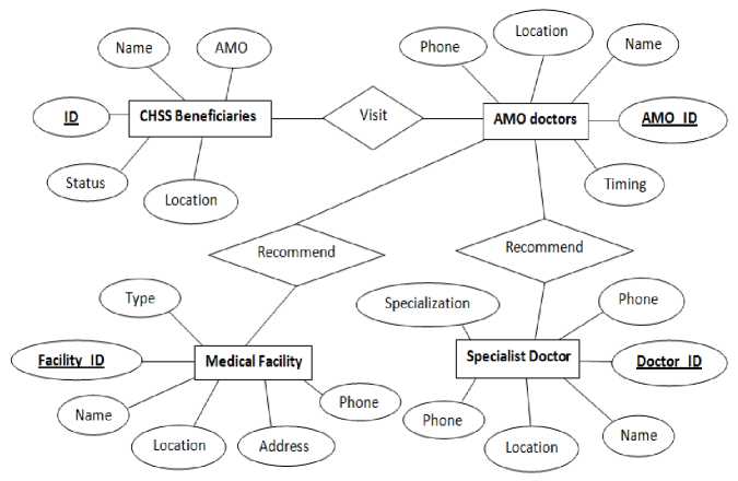
Figure 2. ER Diagram
The point location data (longitude, latitude) of above three datasets were initially in DD:MM:SS format, so they were converted into decimal degrees using excel software by using the following formula:
DD=Degree+(Minute+Second/60)/60
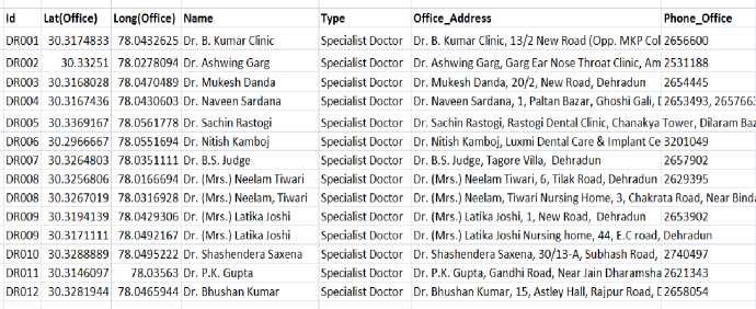
Figure 3. Data (location and attribute) collected about Specialist doctors under CHSS panel in excel format
Later the non-spatial information details were also added as fields in the excel sheet. For example the figure below shows the list of Specialist doctors with non-spatial data like name, office address, phone numbers etc. added to the excel file as shown below
The above steps were repeated for all the three datasets.
Creation of Layers
Open the spreadsheet in Microsoft Excel. Save as a delimited text file. Commas are chosen to use as the delimiter.
Choosing Create layers (“Create a layer from delimited Text file”) option in QGIS to convert tabular data containing spatial information into shapefile.
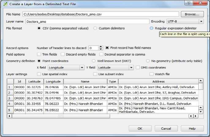
Figure 4. Creating shapefile from excel sheet in QGIS
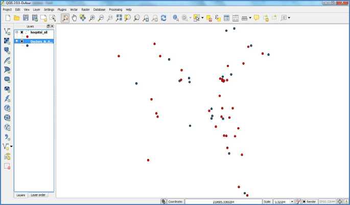
Figure 5. Shapefile of doctors and medical facilities datasets
Shapefile of CHSS beneficiaries was similarly created. The figure below shows the CHSS beneficiaries dataset converted into shapefile in QGIS.
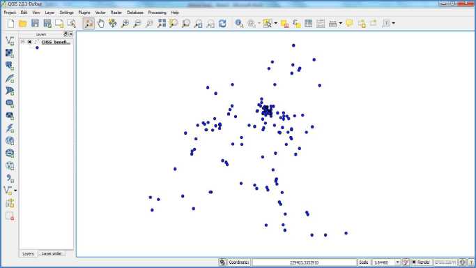
Figure 6. Shapefile of CHSS beneficiaries in QGIS
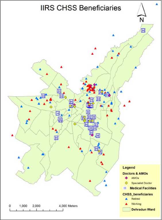
The figure below shows the map composition with all the three layers overlaid on the Dehradun ward map.
DataBase Creation
PostGIS along with PostgreSQL was used as backend spatial database. PostGIS is a spatial database extender for PostgreSQL object-relational database. It adds support for geographic objects allowing location queries to be run in SQL. PostGIS Shapefile Import/Exporter tool was used to dump the shapefiles into the backend database.
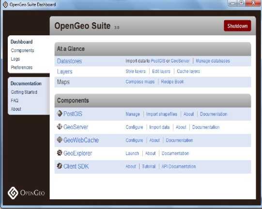
Figure 8. OpenGeo Suite software
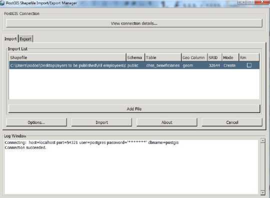
Figure 9. Importing Shapefile into PostGIS
Similarly all the othetr layers including dehradun ward map was stored in post-gis.
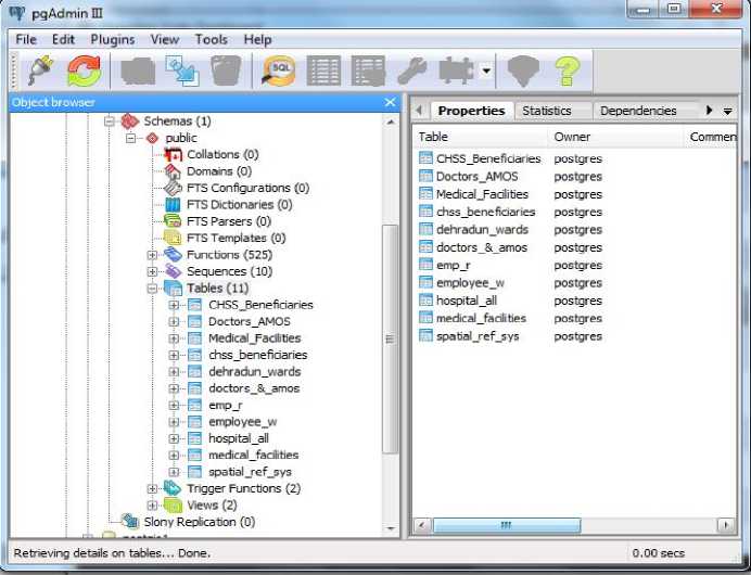
Figure 10. IIRS’s CHSS spatial database containing the data on doctors and medical facilities
Conclusions
During Creation of this database for CHSS beneficiaries, it is observed that webmaping is one of the best methods for representing spatial data and location based information. Also there are many open source and already prepared tools which can be used for developing own webGIS application. Number and capability of these tools are improving day by day related to its popularity and needs.
This project involves creating database of WebGIS based application for CHSS (Contributory Health Service Scheme) beneficiaries of IIRS by using open source tools. This application provides IIRS employees and students (including CSSTEAP students) instant access to information related to the AMO/specialists doctors and medical facilities.
References Creating database for HealthGIS application
- Sheng Gao. “Advanced Health Information Sharing with Web based GIS” 2010, Ph.D. dissertation, Department of Geodesy and Geomatics Engineering, Technical Report No. 272, University of New Brunswick, Fredericton, New Brunswick, Canada, 188 pp.
- Conte A., P. Colangeli, C. Ippoliti, C. Paladini, M. Ambrosini, L. Savini, F. Dall'Acqua, and P. Calistri (2005). "The use of a Web-based interactive Geographical Information System for the surveillance of bluetongue in Italy." OIE Revue Scientifique Et Technique, 24(3), pp. 857-868.
- Fortney J., K. Rost, M. Zhang, and J. Warren (1999). "The impact of geographic accessibility on the intensity and quality of depression treatment." Medical Care, 37(9), pp. 884-893.
- McLafferty S.L. (2003). «GIS and health care» Annual Review of Public Health, 24(1), pp. 25-42.
- Messina J.P., A.M. Shortridge, R.E. Groop, P. Varnakovida, and M. J. Finn (2006). «Evaluating Michigan's community hospital access: Spatial methods for decision support». International Journal of Health Geographics, 5:42. Available at: http://www.ij-healthgeographics.com/content/5/1/42, DOI: 10.1186/1476-072X-5-42
- Lwasa S. (2006). «Planning for Health Infrastructure in Uganda: Where is the need?» GIS Development.
- OpenGeo Suite, http://boundlessgeo.com/solutions/opengeo-suite/, last accessed2/Feb/2014.
