Development of a decision support system of city's social infrastructure accessibility based on GIS-technologies

Author: Tashkin A.O., Hollay A.V.
Section: Управление в социально-экономических системах
Article in issue: 2 т.22, 2022.
Free access
There are three main problems of interaction people with limited mobility with social infrastructure facilities (SIF): the first is physical, the second is the inaccessibility of information about the SIF, and the third is social. The accessibility of SIF and information about it can be ensured through use electronic maps of urban areas and SIF (digital city). These circumstances determine the relevance of the development and creation of a geoinformation support system for decision support in the field of social infrastructure accessibility for people with limited mobility. An original approach to the development and creation of technology to meet the needs for obtaining formalized spatial data, as a social tool for geographic orientation, an information and reference system for supporting decision-making in the field of social development is proposed. The purpose of the study is to develop a system for managing and monitoring the city’s social infrastructure facilities. Materials and methods. The conceptual model of the system was developed using GIS technologies and the theory of formal concept analysis (FCA). The online version is implemented using PHP, JavaScript. Results. The paper presents a methodology for implementing a decision support system. An Internet version of the system has been implemented. The system functionality and interface were tested with the involvement focus groups of people, interested in using the development. Conclusion. A system for managing and monitoring city’s social infrastructure facilities has been developed and implemented. The work is useful in the field of municipal management of social infrastructure, as well as for people with disabilities and researchers.
Dss, gis, management, support, decision-making, map, accessibility, territory, lmgp, sif, geoinformation, system
Short address: https://sciup.org/147237445
IDR: 147237445 | UDC: 519.816
Разработка системы поддержки решений доступности социальной инфраструктуры города на основе ГИС-технологий
Существуют три основные проблемы взаимодействия маломобильных групп населения (МГН) с объектами социальной инфраструктуры (ОСИ): первая - физическая, вторая заключается в недоступности информации об ОСИ, а третья - социальная. Данная категория граждан ограниченна в перемещении и испытывает трудности при взаимодействии с социальной инфраструктурой: в первую очередь, это лица с ограниченными возможностями (инвалиды), составляющие более 15 % населения мира, а также лица, перемещающиеся, например, с багажом или коляской. В мире уделяется значительное внимание формированию безбарьерной среды и улучшению качества жизни МГН, реализуются федеральные законы и целевые программы, направленные на управление процессом обеспечения доступности ОСИ для МГН. Доступность ОСИ и информации о них может быть обеспечена за счет использования электронных карт городских территорий и ОСИ (цифровой город). Указанные обстоятельства обуславливают актуальность разработки и создания геоинформационной системы поддержки принятия решений в сфере обеспечения доступности социальной инфраструктуры цифрового города. Предложен оригинальный подход к разработке и созданию технологии удовлетворения потребностей в получении формализованных пространственных данных, в качестве социального инструмента географического ориентирования, информационно-справочной системы поддержки принятия решений в области социального развития. Целью исследования является разработка системы управления и мониторинга объектов социальной инфраструктуры города. Материалы и методы. Концептуальная модель системы разработана с использованием ГИС-технологий и теории анализа формальных понятий (АФП). Онлайн-версия реализована с использованием PHP, JavaScript. Результаты. В работе представлена методика реализации системы поддержки принятия решений. Реализована интернет-версия системы. Функционал и интерфейс системы протестирован с привлечением фокус-групп, заинтересованных в использовании разработки. Заключение. Разработана и реализована система управления и мониторинга объектов социальной инфраструктуры города. Работа полезна в сфере муниципального управления социальной инфраструктурой, а также для людей с ограниченными возможностями и научных работников.
Text of the scientific article Development of a decision support system of city's social infrastructure accessibility based on GIS-technologies
A significant part of modern society is made up of low-mobility groups of the population (LMGP), these are people with disabilities as well as people moving, for example, with luggage or a stroller. Researchers identify three main problems of the interaction LMGP with social infrastructure: the first is related to the physical barriers of social infrastructure facilities (SIF), the second is the inaccessibility of information about SIF, and the third includes a number of social problems caused by the attitude towards LMGP within society [1]. Information support for the issue of SIF accessibility for LMGP can be increased through the use of urban areas and the SIF electronic maps (digital city) [2]. The problem of developing and improving methods for obtaining and processing information about objects of the social infrastructure of a digital city to ensure the availability of LMGP requires systematization and development of an approach in terms of processing geospatial and socio-economic data [3].
In Russia, for the purpose and execution of laws and state programs, public authorities are taking measures to disclose information regarding the physical accessibility of the SIF in order to increase the awareness of citizens, as well as the passportization of SIF and the introduction of standards to simplify the provision and use of information. To manage this process, tools and systems for managing such information are needed, which justifies the need to develop a decision support system (DSS) in the field of territorial administration. One of the most important problems for the developers of such systems is the problem of technical implementation due to the heterogeneity and weak structure of the initial data, which is one of the main areas of research in this work [4, 5]. At the moment, information portals operate in many municipalities of Russia, the tasks of which include meeting the information needs in the field of SIF accessibility for LMGP. However, often such resources do not have data analysis tools and solve a limited set of problems. The paper describes the tools for expanding the possibilities of analyzing socially-oriented data in order to obtain formalized information about SIF accessibility level.
Methods
Often there are tasks related to the analysis of attributive data, for example, information about the area, length, number and other parameters of objects in the information space. The paper uses a combined approach to the process of processing and combining unstructured disparate data, which implements various algorithms, methods and approaches, thanks to which an original method was obtained for solving the problem of information support in the field of SIF accessibility for LMGP. The main idea of the proposed decision support method is to solve two main tasks:
-
1. Consideration and search of social infrastructure objects on the map and sorting by accessibility levels and other parameters. This problem is solved by means of GIS and spatial analysis.
-
2. The study of structured arrays of attributive, spatial and socio-economic data regarding the accessibility of the SIF. The problem is solved with the help of mathematical methods and algorithms for processing semantic and numerical data.
The initial data for providing information support in the field of SIF accessibility for LMGP have different nature and forms of presentation. The legally established requirements for the accessibility of BSI, maps and city plans, as well as arrays of spatial and attributive data of the existing system of urban social infrastructure form the parameters of models for presenting and structuring data. The scheme of the decision-making process is shown in Fig. 1. Arrays of spatial objects of areal, linear, point information are used to build models for presenting accessibility data using city plans and maps, as well as models for structuring socially-oriented data using the accessibility requirements of SIF [6].
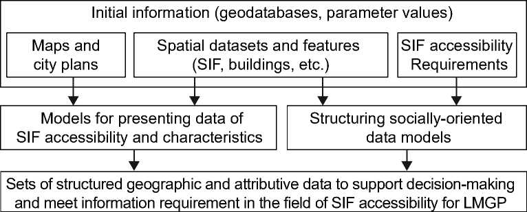
Fig. 1. Decision making process diagram
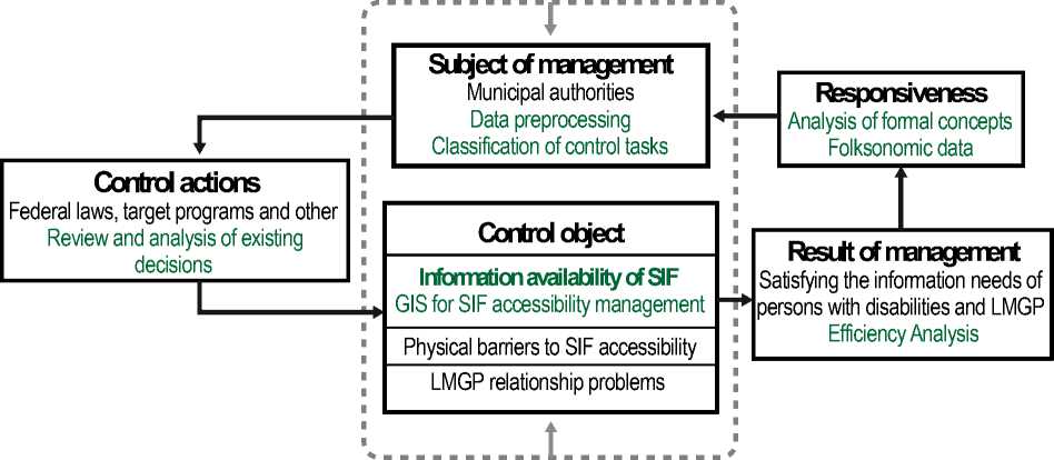
The processes of information provision, processing and analysis of data aimed at supporting decision-making in the field of managing the SIF accessibility for LMGP are laborious and require a long processing time due to the large volume, and are also difficult to identify and compare due to receipt from several sources, which leads to lead to errors and incorrect management decisions.
The presence of a decision support system will reduce time and labour costs, reduce uncertainty and increase the speed of the decision-making process due to the implementation of the possibility of storing and processing a large amount of socio-economic spatial data about the SIF. Fig. 2 shows the decisionmaking process in the area of managing SIF accessibility.
Providing federal and municipal authorities with decision support systems is one of the key tasks in the transition to a digital economy. Large volumes of semi-structured arrays of socio-economic data, their diverse structure and fragmentation make them impossible for manual processing and making reasonable management decisions of social processes. In this way, DSS are aimed at improving the efficiency of decisions and it is customary to use them as the main tool for developing effective management decisions in the field of public administration.
The qualitative difference and peculiarity of the proposed method of spatial analysis lies in the unified representation of SIF, their characteristics, properties and attributives in the form of geoinformation objects and structured arrays of attributive, semantic socially oriented data.
External environment
External environment
Fig. 2. Scheme of SIF accessibility management control
For the analysis and structuring of socio-economic data, the object-attribute representation is not enough. Methods are needed that take into account the folksonomic data structure, usually consisting of three arrays: О = { о j{_ T - array of objects; P = {Pj}j=1 - array of attributives of objects; U = {un}^_T -array of GIS users generating arrays of objects and attributives. Such data structures can be organized using the theory of formal concept analysis (FCA) [2, 7]. The tasks of classifying spatial objects in the digital environment, as well as the structuring of socio-economic data from LMGP, organized according to the principle of folksonomy, are considered to be one of the key tasks for ensuring decisionmaking in the field of ensuring SIF accessibility for LMGP [3, 8].
The development of mathematical models for structuring data of decision support systems is due to the need to improve the quality of information retrieval, processing and presentation of results. Often, methods are used aimed at building an ontology of the information space of a decision support system. Ontology is a knowledge model that can be used to describe the semantics of IS objects. Based on various definitions, ontology is a logical theory that uses the capabilities of a formal language to represent a domain model in the form of a network hierarchical structure of concepts and relationships between them. The ontology can be represented as follows:
0N = ( C , R, L, Pc, PLC, PLR ), where
C = {Q, ..., cm} - array of concepts in the ontology;
R = {r,... , rm} - array of binary relations r(cx, cy) between concepts;
L = { lr. ..., lm} - array of lexical labels (ontology dictionary).
As a result of the analysis of socially oriented Internet services, it was revealed that the data structure of such services can be interpreted in the form of the arrays mentioned above, which have the following properties:
array of objects 0 = { о J;_ ;;
array of objects attributives P = {PjVj=;', array of users U = {un}^_;;
the first two array 0 , P are generated by the third array U 0,P,U = { о ;, Pj, un}^ j_t n=1.
Approaches to the classification of such data structures are commonly called folksonomy. The main problem of folksonomy is the problem of the lack of interconnectedness of data. The solution to this problem can be achieved by combining the folksonomic and taxonomic approaches to data classification, for which the key characteristics of objects and attributives of the information space were determined and a system of relationships between them was implemented. For the first time, a combined classification system was proposed, namely, the main classification table was supplemented with tables of typical values formed during the classification by the folksonomic approach [9].
One of the possible means of extracting ontological concepts and their hierarchies is the theory of formal concept analysis (FCA) (F. Simiano and A. Hotho, 2005) [9, 10]. On the basis of data consisting of three arrays (folksonomic data), it is possible to build a lattice of formal concepts, extract concepts and ontology classes, hierarchical structuring, identify dependencies, and so on. FCA, as a method of replenishing knowledge bases, can be used to build ontologies of a subject area in the form of a sematic multidimensional network.
A method for organizing the ontology of the subject area is proposed by using the GIS for LMGP database of SIF. As before, 0 = { о j{_ T is the array of SIF, P = {pj}j=1 is the array of attributives of the SIF, and to denote the relationship between them, we introduce the array У = {< о,, p j >}^1 j=1, which contains information about which array of attributives each object from the array of SIF is endowed with, , Y с Ox P, relation < о,, p j > means that object о ; has attribute pj. The formal context can be expressed as K = (O , P, У) and represented as a binary matrix (Table 1).
Table 1
Binary matrix of objects of their attributes
|
Pl |
P2 |
Рз |
Pj |
||
|
01 |
1 |
1 |
0 |
1 |
|
|
°2 |
0 |
1 |
1 |
0 |
|
|
°3 |
1 |
1 |
1 |
1 |
|
|
1 |
|||||
|
Oi |
1 |
0 |
1 |
1 |
1 |
Based on two arrays (objects and their attributes) and a known binary relation between them, using Galois operators, one can obtain formal concepts. For arbitrary А с P and В с 0 the Galois operators are defined:
A' = {p G P | V о G А: (о У p)} ;
В' = {о G О | V p G В; (о У p)} .
A' is the array of attributives that all objects represented in array А. B‘ is the array of attributives that all objects represented in array B. The formal concept (А ,B ) includes the array of objects A £ 0 and the array of attributes B £ P satisfying the condition B' = А and A’ = B. А is the volume of a formal concept, which includes a array of objects endowed with certain attributives of the array .
is the content of a formal concept, which includes a array of attributives, one or more objects of the array .
In Fig. 3, the arrays of objects and attributives, as well as the areas of formal concepts, marked with a stroke, are graphically represented as planes. It is customary to visualize the formed lattices of formal concepts using Hasse diagrams, which are a graph covering the relation “to be a more general concept” (Fig. 4). Each lattice vertex is a formal concept [3, 7, 11].
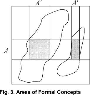
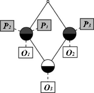
Fig. 4. Formal concept lattice
Results
Let us consider the construction of a lattice of formal concepts using the example of SIF array and its attributives of a GIS, aimed at meeting the information needs of the LMGP (Table 2).
Table 2
A special case of a binary matrix (SIF and their attributives)
|
No. |
– array of objects – array of attributives |
Pl Building |
P2 Road |
Рз Social |
P4 Residential |
P5 Accessible for LMGP |
|
01 |
District Hospital |
1 |
0 |
1 |
0 |
1 |
|
°2 |
UGRASU |
1 |
0 |
1 |
0 |
1 |
|
°3 |
Shopping center “Gostiny Dvor” |
1 |
0 |
1 |
0 |
0 |
|
04 |
Mira street |
0 |
1 |
1 |
0 |
1 |
|
Os |
Mira st., 100 |
1 |
0 |
1 |
1 |
0 |
|
Об |
Traffic light Krasnoarmeiskaya st./ Chekhov st. |
0 |
1 |
1 |
0 |
1 |
|
0? |
Kalinina st., 26 |
1 |
0 |
0 |
1 |
1 |
As a result of the accumulation of a sufficient base of social infrastructure objects and their attributives, it is possible to build a graph using Hasse diagrams to visualize lattices of formal concepts (Fig. 5).
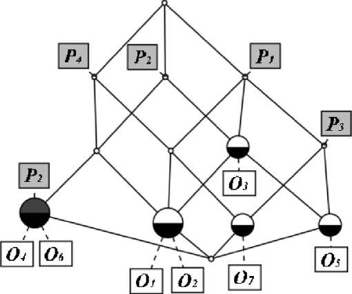
Fig. 5. A special case of a Formal concept lattice (SIF and their attributives)
Formal concepts formed as a result of graph construction are nodes with the largest number of connections. With regard to the case under consideration of SIF and their attributives can assign the formal concepts names as follows [12]:
( ) – Not accessible SIF for LMGP;
(01 , 0 2) — Accessible SIF for LMGP;
( ) – residential buildings not accessible for LMGP;
( ) – residential buildings accessible for LMGP;
(o4, o6) - places accessible for LMGP.
The result of method application is maps with highlighted areas, reflecting the accessibility level of SIF and a detailed SIF description, containing the base parameters of objects [9, 11].
Regarding the software and hardware implementation, due to the social orientation of the system, a client-server architecture was chosen. The modularity of the software implementation is provided by PHP tools, the client application is an object wrapper over a relational database [13, 14]. The decomposition of the system architecture can be represented as five main components [15, 16] (Fig. 6):
Client level
WEB-client
Data display tool
GIS management tool
Business logic layer Applications server
Storage layer DBMS level
CMS
Content Management System Transport between user and DBMS Instrument of combining DB and cartographic basis
Instrument of generating the displayed data
Applications
Computing Modules
Database access module
Graphic display module
Information and analytical module
3D visualization module
Data archives Geodata Metadata Semantic data Calculation results
Geospatial basis Geodata
Semantic data
API Tools
DBMS MySQL
Cartographic
Fig. 6. System architecture
-
1. DB. Structured archives of spatially-referenced cartographic and semantic data, provided with appropriate metadata, stored in the database.
-
2. Cartographic basis. A geospatial field responsible for the interactive presentation of cartographic data using API services.
-
3. CMS. Content management system (platform for publishing Internet sites), which implements the application logic, communication with API mapping services and provides work with the data warehouse.
-
4. Applications. A set of software modules implemented in PHP.
-
5. Web Client. Graphical user interface implemented as a Web application (Internet resource).
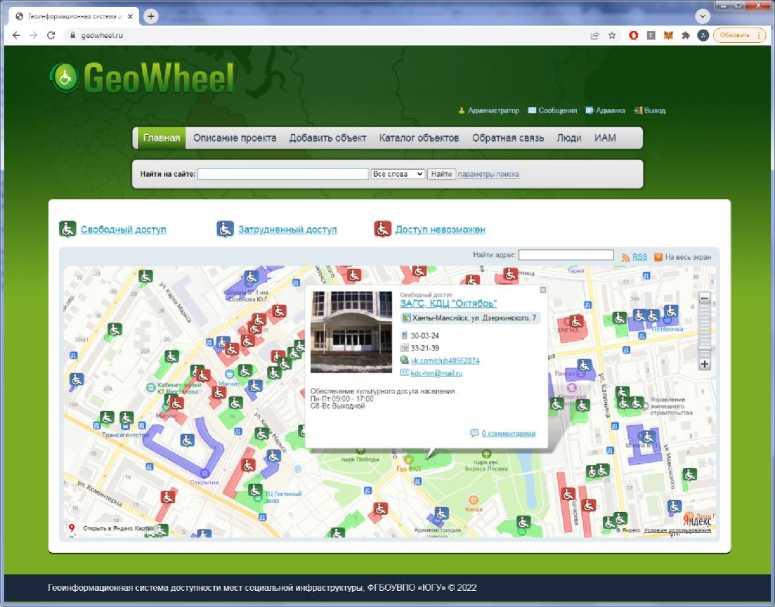
Fig. 7. Screenshot of the created system
Discussions and Conclusions
A new method of automatic analysis and folksonomic data extraction using formal concepts analysis theory, aimed at supporting the decision-making process, has been proposed and tested. A model for the folksonomic data classification based on the FCA theory has been developed, that is provides information support process for decision-making in the field of ensuring SIF accessibility for LMGP.
A decision support system has been created that implements the developed models and methods to support the decision-making process in the field of SIF accessibility managing state for LMGP. A software and hardware complex based on geoinformation technologies has been implemented, that makes possible to accumulate, systematize, and effectively use folksonomic data to support managing process of SIF accessibility for LMGP and research tasks.
The system is used by LMGP as a tool for spatial orientation, as well as by municipal authorities to make managerial decisions regarding informational provision and physical accessibility of social infrastructure facilities. In particular, it has been introduced into the work of wheelchair users regional public organisation “Preobrazovanie” and to the Khanty-Mansiysk branch of the Federal Autonomous Organisation “Main State expertise of Russia” as a decision support system in the field of SIF accessibility for LMGP.
References Development of a decision support system of city's social infrastructure accessibility based on GIS-technologies
- Tashkin A.O., Semenov S.P. Methodology for the development of a geographic information system for people with limited mobility. Modern Problems of Science and Education. 2014;(1). Available at: http://www.science-education.ru/115-12206 (accessed 05.10.2021). (In Russ)
- Semenov S.P., Tashkin A.O. [Interactive geographic information system for people with limited mobility]. In: Collection of scientific articles of the international conference "Lomonosov readings in Altai: fundamental problems of science and education". Barnaul: Altai University; 2015. P. 1007-1010. (In Russ)
- Semenov S.P., Slavsky V.V., Tashkin A.O. The analysis of the information resources directed on satisfaction in information needs of physically disabled people. VestnikNSU. Series: Information Technologies. 2016;14(1):83-102. (In Russ)
- Bulygin Yu.E. Organization of social management (basic concepts and categories). Reference dictionary. Ed. Prof. I.G. Bezuglov. Moscow: Kontur; 2002. 234 p. (In Russ)
- Vdovin V.M., Surkova L.E., Valentinov V.A. Systems theory and systems analysis: textbook. Moscow: Dashkov i K; 2010. 640 p. (In Russ)
- Rakesh Kumar Sharma, Durga Prasad Sharma. Review of spatial decision support systems in resource management. Review of Business and Technology Research. 2012;6(1): 167-174.
- Belkacem L., Hadda D., Akakba A. Gis-based multicriteria spatial decision support system model to handle health facilities resources. Case of crisis management in Batna, Algeria. Geographia Technica. 2020;15(1): 173-186. DOI: 10.21163/GT_2020.151.16
- Sultani R.M., Soliman A.M., Al-Hagla K.S. The Use of Geographic Information System (GIS) Based Spatial Decision Support System (SDSS) in Developing the Urban Planning Process. APJ, Architecture & Planning Journal. 2009;20:97-115.
- Cimiano P., Hotho A., Staab S. Learning Concept Hierarchies from Text Corpora using Formal Concept Analysis. Journal of Artificial Intelligence Research. 2005;24:305-339. DOI: 10.1613/jair.1648
- Cimiano P. Ontology Learning and Population from Text: Algorithms, Evaluation and Applications. Springer, New York; 2006. 312 p. DOI: 10.1007/978-0-387-39252-3
- Semenov S.P., Slavsky V.V., Tashkin A.O. [Mathematical model of a socially oriented geoinformation system for people with limited mobility]. In: International conference "Mathematics and information technologies in the oil and gas complex" dedicated to the birthday of the great Russian mathematician, academician P.L. Chebysheva: Abstracts. Surgut: Scientific Center of SurGU; 2016. P. 146-149. (In Russ)
- Semenov S.P., Slavskiy V.V., Tashkin A.O., Tyakunov A.S. Mathematical model of social infrastructure based on the theory of formal concept analysis (FCA). International Journal of Engineering and Technical Research (IJETR). ISSN: 2321-0869 (O) 2454-4698 (P). 2017;8(1):1-3.
- Arampatzis G., Kiranoudis C.T., Scaloubacas P., Assimacopoulos D. A GIS-based decision support system for planning urban transportation policies. European Journal of Operational Research. 2004;152:465-475. DOI: 10.1016/S0377-2217(03)00037-7
- Tashkin A.O., Semenov S.P., Slavsky V.V. [Socially-oriented geoinformation systems, models and methods of implementation]. In: Geoinformation technologies in solving problems of rational nature management: Proceedings of the III All-Russian scientific-practical conference of "URIIT". Khanty-Mansiysk; 2017. P. 62-68. (In Russ)
- Novikov D.A. Teoriya upravleniya organizatsionnymi sistemami [The theory of management of organizational systems]. 3rd ed. Moscow: Publishing house of physical and mathematical literature; 2012. 604 p. (In Russ)
- Xia J., Lin L., Lin J., Nehal L. Development of a GIS-Based Decision Support System for Diagnosis of River System Health and Restoration. Water. 2014;6:3136-3151. DOI: 10.3390/w6103136
