Diagnostic features of the soils of the Besitchay State Natural Reserve (Azerbaijan)
")
Author: Ahmedova S., Ismayilzade N., Musayev V.
Journal: Бюллетень науки и практики @bulletennauki
Section: Науки о земле
Article in issue: 8 т.9, 2023.
Free access
In the presented article, the geographic position, relief, geological and geomorphological structure, climate, and soil-vegetation cover of the Basitchay State Reserve are given in detail, and some fertility indicators of the main soil types formed in the area are analyzed. The amounts of absorbed bases, active and exchangeable forms of nutrients (NPK) were determined along with humus, total nitrogen, pH, which are diagnostic indicators of soils.
Basitchay reserve, soil type, diagnostic signs, fertility, humus, ph, absorbed bases
Short address: https://sciup.org/14128690
IDR: 14128690 | UDC: 631.46 | DOI: 10.33619/2414-2948/93/04
Диагностические признаки почв Беситчайского государственного природного заповедника (Азербайджан)
Приведены географическое положение, рельеф, геолого-геоморфологическое строение, климат, почвенно-растительный покров Беситчайского государственного природного заповедника Азербайджанской Республики, а также проанализированы некоторые показатели плодородия основных типов почв, сформировавшихся на территории. Определены количество поглощенных оснований; поглощенных, подвижных и обменных форм элементов питания (NPK); а также величина гумуса, общего азота, рН, которые являются диагностическими индикаторами почв.
Text of the scientific article Diagnostic features of the soils of the Besitchay State Natural Reserve (Azerbaijan)
Бюллетень науки и практики / Bulletin of Science and Practice
Since the drastic change of the biosphere as a result of anthropogenic impact is a global disaster, the anthropogenic landscape can be evaluated as the landscape of the future. It can be assumed that after 100-200 years, the anthropogenic landscape will cover all areas of the earth’s surface, except for permafrost and high mountain areas. This is due to the high natural growth of the world’s population, the continuous development of industry and agriculture, the increase in people’s demand for energy sources, etc. can be attributed. As a result, humanity will be faced with the creation of sustainable, new optimal landscapes that can provide it with oxygen, water, food, and energy. Without protecting the gene pool of animals and plants, without knowing the basic laws of nature that form the basis of the functioning of the ecosystem and biodiversity in general, we will face a helpless, helpless situation [1].
As a result of environmental imbalance in large areas of the arid regions of the Earth, a number of environmental problems that pose a real threat to human life appear. Under the influence of incompetent management methods, unstable natural landscapes (forests, meadows, pastures) are destroyed, along with the expansion of the network of ravines as a result of floods, landslides, water erosion, as well as widespread irrigation erosion, soil re-salination and hundreds of thousands of hectares of fertile land are removed from the cycle of use as a result of anthropogenic intervention. The urgency and importance of solving this problem put it among the problem that limits the ecological, economic, and food security of the country and create tension in its regions. Thus, regulation of agricultural and ecological balance is defined as a strategic priority and (after the oil, industry) is reflected in State Programs as a direction of socio-economic development of the state [2, 3].
For 30 years, our Armenian neighbors, who occupied the most fertile lands of our Republic and exploited their above-ground and underground resources, built fortifications in the area, destroyed the natural structure of the land, destroyed the biodiversity by burning forests, blocked water sources and used them only for their purposes. But, as all things come to an end, this too has come to an end. Thanks to the decisive position, perseverance, far-sighted policy of the Commander-in-Chief Mr. Ilham Aliyev, and the courage of our brave soldiers, our lands were once and irreversibly returned within 44 days and the territorial integrity of Azerbaijan was ensured.
One of the relevant aspects of our research is the fact that Azerbaijani researchers have been deprived of conducting research in this area for 30 years, a step taken by us to assess the modern state of natural landscapes, especially the ecosystem in Basitchay State Reserve.
Object and Methodology of the Research
The Basitchay State Reserve, accepted as a research object, is located on the right bank of Basitchay, in the Zangilan district, within the East Zangezur economic region. The territory of the reserve is 39°03ʹ09ʺ N and 46°36ʹ46ʺ E. In geographical coordinates, it is at an altitude of h = 600800 m above sea level and has a total area of 107 ha. Its length is 15 km, and its width reaches 150200 m. As the smallest reserve of the republic, it occupies 79.4% of the territory, 0.001% of the area of Azerbaijan, and 0.005% of the total area of the republic’s reserves [4].
To determine the physical, chemical, and physicochemical properties of the soil samples taken, appropriate analyzes were conducted at the Institute of Soil Science and Agrochemistry of the Ministry of Science and Education of the Republic of Azerbaijan using the following accepted methods: hygroscopic moisture — according to N. A. Kachinsky and R. H. Mammadov, humus — according to I. V. Tyurin method, absorbed bases according to K. K. Gedroits, the response of the medium was determined by a pH-potentiometer. Nutrients: absorbed ammonia — with the help of the Nessler reagent in the calorimeter, nitrate nitrogen — Grandval-Lajoux, total nitrogen, and phosphorus — Kjeldahl, secondary phosphorus — by the method of B. P. Machigin, water-soluble phosphorus — by Deniges, and exchangeable potassium — by the method of P. B. Protasov determined in the photometer.
Soil types were determined based on the 1:200000 large-scale soil map of the economic regions of Azerbaijan by A. I. Ismayilov, M. P. Babayev, V. H. Hasanov, and S. M. Huseynova [5].
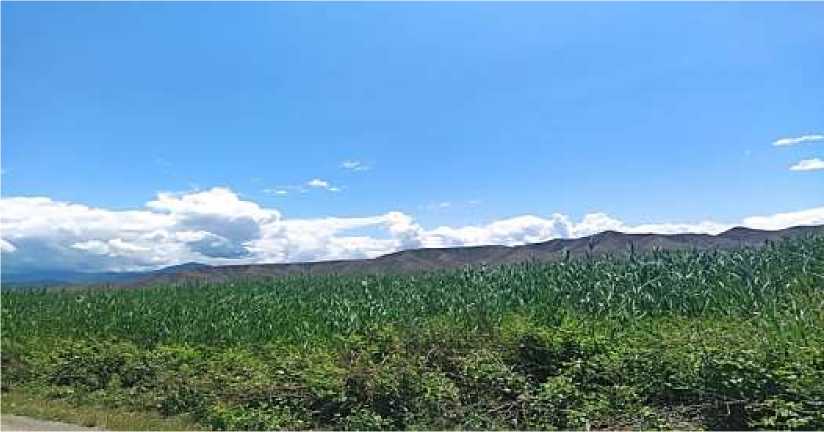
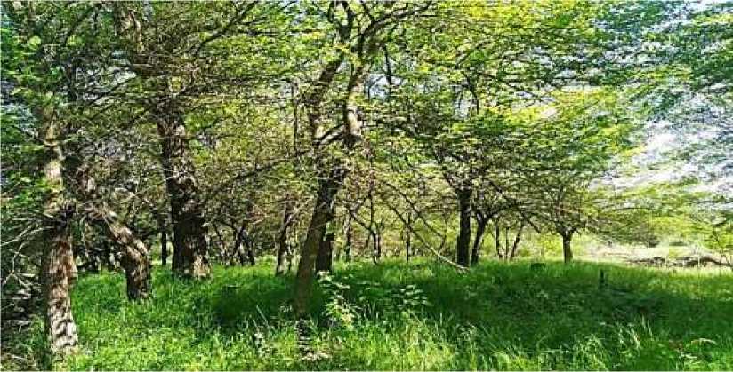
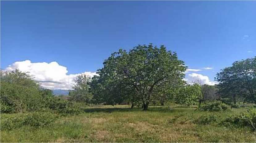
Figure. General view of the research object
Analysis and Discussion
Soil science as a scientific science was formed by V. V. Dokuchayev, P. A. Kostichevin, and N. M. Sibirsev was an outstanding classicist who was the founder of genetic soil science at the end of the 19th century. They considered the soil as an independent natural body, different from other natural bodies, having its characteristics and properties, and most importantly, fertility that distinguishes it from the parent rock, which is the original material.
The development of genetic soil science in Azerbaijan is associated with the names of P. Smirnov-Loginov, V. R. Volobuyev, H. A. Aliyev, M. M. Salayev, K. A. Alekbarov, M. R. Abduyev, S. A. Aliyev, R. G. Mammadov, I. Sh. Isgandarov and others. Later, successfully continuing the research conducted by prominent scientists in the field of diagnosis and classification of soils during the time of their successors M. P. Babayev, A. I. Ismayilov, V. H. Hasanov, Ch. M. Jafarova, S. M. Huseynova, 1:100000 and 1:100000 they compiled 1:200000 large-scale soil maps and improved the classification of soils according to the International WRB system [5, 6].
The formation of mountain folds of the Lesser Caucasus belongs to different geological periods. The main stage of disintegration, which creates the characteristic features of the modern relief of the Lesser Caucasus, coincides with the end of the Pliocene period, when large vertical uplifts occurred in individual parts of the territory, complicated by faults and displacements.
According to the geomorphological division, the following main relief types are distinguished in the Lesser Caucasus: 1. Glacial-erosion; 2. Ancient leveled surfaces (peneplains); 3. morphosculpture-tectonic, mountainous-erosion; 4. Relief of Young (Pliocene-Quaternary) lava heights [7, 11].
The area where the reserve is located is mostly mountainous, with an altitude of 600-800 m above sea level. The right bank of Basitchay consists of hills. Mainly Tertiary sediments are spread. A narrow alluvial plain stretch along the river valley. The mountains here are significantly divided by the tributaries of the Basitchay [7].
All the main geological processes that took place in the territory of the Lesser Caucasus since the end of the Oligocene were at the same time the main stages of its morphological development. Numerous geological studies have established that the Lesser Caucasus region entered the continental phase at the end of the Oligocene, which in turn is confirmed by the presence of Oligocene marine sediments in the eastern part. Since this period, the entire region of the Lesser Caucasus has been subjected to uneven uplift, as a result of which ridge breaks were formed in the Neogene, and river terraces were formed in the Quaternary period. Cenozoic Paleogene and Neogene sediments are widespread in the Basitchay reserve, and alluvial sediments are widespread in the river valley [8, 11].
The territory of the reserve belongs to the mild-warm climate type with dry winters and hot summers. The total solar radiation in the area is 130, and the annual radiation balance is 48 kcal/cm2. Here, the annual total of sunny hours is up to 2200-2500; the total active temperature is 4100-43000, which has a positive effect on the normal development of plants. The annual air temperature is 13°C; the absolute min temperature is 21° C, and the absolute max temperature reaches 41°C. The amount of annual precipitation is 600 mm. The snow cover is mostly thin (10-20 cm), in some years its thickness reaches 70-80 cm. The relative humidity of the air is 60-70% (Table 1) [9].
The hydrography of the Basitchay reserve and its surrounding areas mainly consists of the Basitchay and its tributaries such as the Sobchay, Topchay, and Shikhauz. The length of Basitchay is 44 km, and the area of its basin is 354 km2. It starts from the Zangezur range and flows into the Araz River. It is mainly fed by snow, and rain, and partly by groundwater. Floods happen. Most of its annual flow is observed in spring and autumn. Since it is used for irrigation in summer, the water sometimes does not reach the Araz River [10].
Table 1
THE MAIN CLIMATE INDICATORS
|
Indicators |
Months |
s £ |
|||||||||||
|
I |
II |
III |
IV |
V |
VI |
VII |
VIII |
IX |
X |
XI |
XII |
||
|
Total radiation, kcal/cm2 |
5.5 |
6.8 |
9.8 |
12.1 |
13.8 |
17.4 |
17.4 |
16.3 |
12.1 |
8.6 |
5.9 |
4.8 |
130.5 |
|
Radiation balance, kcal/cm2 |
0.4 |
1.8 |
4.1 |
5.4 |
6.2 |
8.0 |
7.3 |
6.7 |
4.9 |
2.5 |
1.1 |
0.0 |
48.4 |
|
Average temperature, C° |
1.0 |
2.8 |
7.0 |
12.1 |
18.2 |
22.2 |
25.3 |
24.8 |
20.2 |
14.5 |
8.3 |
3.0 |
13.3 |
|
Absolute minimum temperature, C° |
-21 |
-18 |
-14 |
-5 |
2 |
5 |
11 |
9 |
2 |
-5 |
-15 |
-15 |
-21 |
|
Absolute maximum temperature, C° |
24 |
28 |
32 |
35 |
36 |
41 |
41 |
40 |
39 |
36 |
30 |
26 |
41 |
|
Relative humidity, % |
72 |
71 |
75 |
65 |
64 |
56 |
51 |
53 |
66 |
71 |
77 |
74 |
66 |
|
Precipitation, mm |
16 |
21 |
33 |
55 |
89 |
77 |
36 |
27 |
37 |
37 |
24 |
14 |
467 |
|
Possible evaporation, mm |
29 |
33 |
45 |
68 |
95 |
131 |
170 |
156 |
100 |
65 |
38 |
37 |
966 |
Natural landscape areas in the territory of the reserve are not very diverse: 79.4% of the territory is covered with forest, and 14% is sparsely forested. 6.5% of unforested areas are covered with sand and stone accumulations of the Basitchay deposit. The main tree species of the forested area is the eastern sycamore. Here, mainly one type of forest is formed — sycamore forests with various grasses. Poplar species are also mixed with sycamore from the side of the river.
Wolf, wild boar, badger, roe deer, rabbit, various rodents, etc. are found in the surrounding areas of the reserve, and sometimes in the reserve itself. birds are found. In the territory of the Basitchay state reserve, mainly irrigated alluvial-meadow soils have developed around the river valleys and cultivated mountain-gray-brown and mountain-forest brown soils have developed in the surrounding areas of the reserve. The alluvial-meadow soils in the reserve area have average quality indicators. These soils are spread in river basins and cones at an altitude of 15-100 m above sea level. Soil-forming rocks consist of carbonate-non-carbonate clayey-coal alluvial and sandy river stone alluvial-proluvial sediments. The thickness of the mined layer is 45-50 cm, the planting layer is 25-30 cm. The color of the humus layer is dark gray-brown, its thickness is 40-50 cm, and its content is 2.0-2.5%. According to the granulometric composition, this soil type is medium to heavy gritty, the amount of physical clay (<0.01 mm) is between 35-60%, the reaction of the environment fluctuates in a large interval; it is between 7.5-9.3, that is, from a neutral environment to a highly alkaline one. In the territory of the Basitchay reserve, mainly mountain-forest brown, cultivated mountain-brown, gray mountain-brown, mountain-forest is located in mesophilic forests in the high forest layer, and mountain-meadow soils are formed in subalpine meadows [5, 6, 11].
According to their physical properties, the soils of sycamore forests are mainly fertile soils with medium and heavy grains, good hydro-physical properties, high productivity, and a bonity score. Section no. 1 is located on the right bank of Basitchay, near the village of Garagoz, on the terrace of the river valley, at an altitude of 389 m above sea level. Its geographical coordinates are 39°01ʹ38.0ʺ N, 46°39ʹ11.4ʺ E. The plants are ephemeral.
Section No. 1 is located on the cultivated mountain gray-brown soils in the low mountain and foothill plains. Soil-forming rocks consist of limestone conglomerates and late diluvial sediments. When analyzing the results of physical, chemical, and physicochemical analyzes of soil samples taken from the crop layer, it should be noted that these soils are heavy granular and light clay based on their granulometric composition. The amount of physical clay (<0.01 mm) ranges from 52-75%, and the density of the soil is 2.11-1.39 g/cm3. While the amount of humus in the upper 0-10 cm soil layer was 2.0%, and total nitrogen was 0.112%, it decreased sharply as the depth increased, and in the 10-20 cm layer, it was 0.89%, and total nitrogen was 0.056%, respectively. The ratio between C:N was around 7.6-7.0 in the upper horizon, which indicates moderate enrichment of humus with nitrogenous compounds. According to the scale of R. H. Mammadov [12], cultivated mountain gray-brown soils are evaluated as having low humus. From the upper layer to the lower layer, the hygroscopic moisture increases slightly and is 1.46-5.41%.
The reaction of the environment pH is very close to the neutral environment, it remains stable almost without changing towards the depth (pH=7.77-7.78). In general, while the number of bases is underestimated in the upper 0-10 cm layer (19.8 mg-eq), according to R. H. Mammadov, the absorption capacity is estimated as satisfactory in the 10-20 cm layer (27.4 mg-eq). It should be noted that since Mg values are low 0.1-2.0 mg-eq throughout the profile (5.1–7.3%), Ca2+ ions are dominant at 18.8 and 25.4 mg-eq or 94 .9-92.7% (Table 2).
Table 2
SOME INDICATORS OF FERTILITY
|
№ |
5 |
£ |
S |
Absorbed bases |
Food items, mg/kg |
||||||
|
mg-eq/100 g Ca2+ Mg2+ Total |
Ca2+ |
% Mg2+ |
N/NH 3 |
P 2 O 5 |
K 2 O |
||||||
|
Mineralized mountain-gray-brown soil |
|||||||||||
|
1 |
0-10 |
2.0 |
0.112 |
7.77 |
1.46 |
18.8 1.0 19.8 |
94.9 |
5.1 |
9.48 |
68.76 |
214.91 |
|
2 |
10-20 |
0.89 |
0.056 |
7.78 |
1.51 |
25.4 2.0 27.4 |
92.7 |
7.3 |
25.22 |
40.00 |
142.55 |
|
Mountain- forest-brown soil |
|||||||||||
|
1 |
0-10 |
3.1 |
0.182 |
7.80 |
1.64 |
18.8 1.4 20.4 |
92.2 |
7.8 |
15.52 |
51.25 |
223.78 |
|
2 |
10-20 |
2.2 |
0.126 |
7.66 |
2.04 |
22.4 1.4 23.8 |
94.1 |
5.9 |
19.40 |
35.00 |
218.86 |
|
3 |
20-30 |
0.93 |
0.056 |
7.54 |
1.53 |
23.6 1.6 25.2 |
93.7 |
6.3 |
25.22 |
26.66 |
195.48 |
Mined mountain-brown soils are poor in nutrient concentration. As can be seen in Table 2, the amount of hydrolysable nitrogen in the upper 0-10 cm layer was very low, almost non-existent (N/NH 3 = 9.48 mg/kg), its indicators were 2.5 in the 10-20 cm layer. Despite the increase (N/NH 3 = 25.22 mg/kg), it is still assessed as poorly provided. Compared to hydrolysable nitrogen, the amount of activated phosphorus (P 2 O 5 ) was quite high, 68.76 mg/kg in the 0-10 cm layer, and 40.00 mg/kg in the 10-20 cm layer is evaluated as provided. These soils are also poorly supplied with exchangeable potassium (K 2 O). The indicators of this nutrient were 214.91 mg/kg in the upper 0-10 cm layer of the soil, and 142.55 mg/kg in the lower 10-20 cm layer, which was 2 times lower than the allowable limit and very poorly supplied is evaluated.
Cut №2 was also placed on the right bank of Basitchay, near the village of Ordakli, at the foot of the mountain, in the forest area at an altitude of 434 m. Geographic coordinates are 39°02ʹ26.0ʺ N, 46°38ʹ58,40ʺ E. The mountain-forest brown soils formed here are heavy gravelly and light clay. In the area where mountain-forest brown soils develop, the annual amount of atmospheric precipitation is 450-600 mm, the average annual temperature is 8.4-10.8°C, the relative humidity coefficient >0.5-0.7, >10°C active temperatures total 3400-40000.
The climate belongs to the Mediterranean type; it is subtropical with dry winters and hot summers. The vegetation is mainly oriental sycamore and oak trees. The analysis of the results of physical, chemical, and physicochemical analysis of soil samples taken from the crop layer of section No. 1, placed on mountain-forest brown soils, clearly shows that they differ from the previously analyzed civilized mountain gray-brown soils according to their diagnostic signs. Thus, this soil type is formed from limestones and sandstones, carbonate clay shales, on eluvial, eluvial-diluvial weathering products, and according to its granulometric composition, it is heavy granular and light clay, the amount of physical clay (<0.01 mm) is 56-69%. the amount of physical silt (<0.001 mm) varies between 26-39%, volume mass is 1.24-1.32 g/cm3, soil density fluctuates around 1.25-1.32 g/cm3. The thickness of the forest floor is 3-5 cm, the root system is spread 40-50 cm deep. The color of the humus layer is dark brown, and its content is 3.1% in the upper 0-10 cm layer, and total nitrogen is 0.182%, in the lower 10-20 cm layer, it decreases somewhat regularly to 2.2%, in the 20-30 cm layer and it has already sharply decreased to 0.93%. The amount of total nitrogen is 0.182 for layers, respectively; It was 0.126 and 0.056%. The ratio between C:N was between 8.6 and 9.5 in the upper horizon, which indicates sufficient enrichment of humus with nitrogenous compounds. According to the scale of R. H. Mammadov [11], mountain-forest brown soils are evaluated as sufficient, that is, satisfactory. While the hygroscopic humidity is 1.64% in the upper 0-10 cm layer, it increases to 2.04% in the 10-20 cm layer and decreases to 1.53% in the 2030 cm layer.
The reaction of the environment is pH neutral, and its indicators vary in a narrow range along the depth (pH=7.80-7.54), the number of bases in the absorption capacity complex varies between 20.4-25.2 mg/eq along the layers of the profile according to R. H. Mammadov [11] (0-30 cm) is considered sufficient. In the absorption complex, Ca is in the leading position, 18.8-23.6 mg-eq or 92.2-93.7%. Mg values were significantly lower, ranging from 1.4 to 1.6 mg-eq or 7.8 to 6.3% (Table 2).
Mountain-forest brown soils are also poor in nutrient accumulation. As shown in Table 2, the amount of hydrolysable nitrogen (N/NH 3 ) was 15.52 mg/kg in the upper 0-10 cm layer and gradually increased to 19.40 mg/kg in the 20-30 cm layer. and in the layer, it increased slightly and amounted to 25.22 mg/kg, and it is still considered very poorly provided. The amount of active phosphorus (P 2 O 5 ) varies with depth. So, in the upper 0-10 cm layer, its indicators are high and 51.25 mg/kg — while it is highly secured, in the 10-20 cm layer it decreases to 35.00 mg/kg, and in the 20-30 cm layer — 26, 66 mg/kg, it was evaluated as poorly secured. These soils are also poorly supplied with exchangeable potassium (K 2 O). Its indicators were 223.78 mg/kg in the upper 0-10 cm layer of the soil, 218.86 mg/kg in the lower 10-20 cm layer, and 195.48 mg/kg in the 20-30 cm layer. is assessed as very poorly secured.
Conclusion
Based on the soil research conducted in the territory of the Basitchay State reserve and the general consideration given to the landscape, it can be concluded that, compared to the soil research conducted 30-35 years ago, the diagnostic characteristics of the soil of the reserve area, especially the amount of humus, which is the main indicator of soil fertility, and the concentration of nutrients a noticeable decrease was observed. In this regard, to protect the fertility of the soil, and to eliminate the negative anthropogenic impact on the ecosystem, we consider it expedient to carry out extensive propaganda work on conservation education among the population. It would be important to organize a natural museum related to the protection and growth of the eastern sycamore, which is important here.
Several technical and biotechnical measures should be taken in the territory of the reserve. The most necessary of such measures is to fully comply with the protection regime in the territory of the reserve, which is affected by the negative activities of public farms and the local population, and which is surrounded by several villages, and according to the legislation of the State, control in this area should be strengthened.
References Diagnostic features of the soils of the Besitchay State Natural Reserve (Azerbaijan)
- Flint, V. E. (2002). Sokhranenie i vosstanovlenie bioraznoobraziya. Moscow. (in Russian).
- Kerimov, A. M., & Samedov, P. A. (2019). Ekologicheskie, energeticheskie i ekonomicheskie puti povysheniya plodorodiya i produktivnosti pochv, ikh problemy i prikladnoe znachenie. LAP Lambert Academic Publishing. (in Russian)
- Sultan-zade, F. V. (2015). Biodiversity and its protection. Baku. (in Russian).
- Mamedov, G. Sh., & Khalilov, M. Yu. (2015). Ekologiya i okhrana okruzhayushchei sredy, Baku. (in Azerbaijan)
- Zemel'naya karta Azerbaidzhana po ekonomicheskim raionam masshtaba 1:200000, Baku 2022. (in Azerbaijani)
- Antonov, B. A. (1971). Geomorfologiya i voprosy noveishei tektoniki yugo-vostochnoi chasti Malogo Kavkaza. Baku. (in Russian).
- Azizbekov, Sh. A. (1947). Geologiya i petrografiya severo-vostochnoi chasti Malogo Kavkaza. Baku. (in Russian).
- Madatzade, A. A., Shikhlinskii, E. M., & Kavetskaya, G. G. (1968). Klimat Azerbaidzhana. Baku. (in Russian).
- Rustamov, S. G., & Kashkai, R. M. (1989). Vodnye resursy Azerbaidzhanskoi SSR. Baku. (in Russian).
- Salaev, M. E. (1966). Pochvy Malogo Kavkaza: (V predelakh AzSSR). Baku. (in Russian).
- Mamedov, R. G. (1970). Agrofizicheskaya kharakteristika pochv Priaraksinskoi polosy. Baku. (in Russian)
