Ecological and Geographical Analysis of Landscapes of the State Nature Reserve of the Group of Mud Volcanoes using GIS and NDVI

Автор: Yunuslu T., Aghbabali A.
Журнал: Бюллетень науки и практики @bulletennauki
Рубрика: Естественные науки
Статья в выпуске: 6 т.12, 2026 года.
Бесплатный доступ
This study presents an integrated ecogeographical analysis of selected mud volcano landscapes within the Mud Volcanoes Group State Nature Reserve in Azerbaijan. The research focuses on ten representative mud volcanoes covering approximately 488 km² and aims to identify spatial patterns and ecological differentiation under semi-arid environmental conditions. The methodological framework is based on the integration of remote sensing data, digital elevation models (DEM), and geographic information systems (GIS). Relief characteristics, slope distribution, soil cover, and vegetation patterns were systematically analyzed to determine the relationships between geomorphological and ecological components of the landscape. The results indicate that the study area is predominantly characterized by lowland and gently sloping terrain, with elevations ranging from –21 m to 436 m. Saline and semi-saline soils dominate, significantly limiting vegetation development. Vegetation cover is sparse and mainly represented by halophytic and xerophytic species adapted to arid conditions. NDVI-based analysis revealed spatial variability and a temporal decline in vegetation density, indicating increasing aridity and environmental stress across the study area. Larger mud volcanoes exhibit more complex geomorphological structures and relatively higher ecological diversity. This study provides an integrated ecogeographical assessment by combining DEM-based geomorphological analysis with NDVI-derived vegetation dynamics, offering a novel perspective on mud volcano landscape systems. The findings contribute to sustainable management, conservation planning, and future geopark development.
Mud volcano landscapes, vegetation patterns, NDVI analysis, GIS and remote sensing, soil–vegetation relationships, ecogeographical differentiation
Короткий адрес: https://sciup.org/14138230
IDR: 14138230 | УДК: 502.72 | DOI: 10.33619/2414-2948/127/20
Эколого-географический анализ ландшафтов государственного природного заповедника группы грязевых вулканов с использованием ГИС и NDVI
Представлен интегрированный эколого-географический анализ ландшафтов грязевых вулканов, расположенных на территории Государственного природного заповедника группы грязевых вулканов Азербайджана. Исследование охватывает десять репрезентативных вулканов общей площадью около 488 км² и направлено на выявление пространственных закономерностей и экологической дифференциации в условиях аридного климата. Методология основана на интеграции данных дистанционного зондирования, цифровых моделей рельефа (ЦМР) и геоинформационных систем (ГИС). Были проанализированы характеристики рельефа, уклоны поверхности, почвенный покров и растительность с целью определения взаимосвязей между геоморфологическими и экологическими компонентами ландшафта. Результаты показывают, что территория представлена преимущественно равнинным и слабоволнистым рельефом с высотами от –21 м до 436 м. Преобладают засоленные и слабозасоленные почвы, что существенно ограничивает развитие растительности. Растительный покров разрежен и представлен в основном ксерофитными и галофитными видами. Анализ на основе NDVI выявил пространственную изменчивость и временное снижение плотности растительности, что свидетельствует об усилении аридности и экологического стресса. Крупные грязевые вулканы характеризуются более сложной морфологией и бóльшим экологическим разнообразием. Исследование объединяет геоморфологический анализ на основе ЦМР с динамикой растительности по данным NDVI, предлагая новый подход к изучению ландшафтов грязевых вулканов. Полученные результаты могут быть использованы для устойчивого природопользования и охраны окружающей среды.
Текст научной статьи Ecological and Geographical Analysis of Landscapes of the State Nature Reserve of the Group of Mud Volcanoes using GIS and NDVI
Бюллетень науки и практики / Bulletin of Science and Practice
UDC 502.72
Mud volcanoes represent one of the most unique geological and geomorphological phenomena in the world, and their spatial concentration in the territory of Azerbaijan significantly increases their scientific, ecological, and geotouristic importance. It is estimated that more than 350 mud volcanoes and their manifestations are located within the country, accounting for a considerable proportion of the global distribution of such formations. This exceptional concentration has led to the establishment of the Mud Volcanoes Group State Nature Reserve, which includes 43 protected mud volcanoes and their surrounding landscapes. The protection and scientific investigation of these areas have become increasingly relevant, particularly in the context of sustainable environmental management and the prospective designation of the territory as a geopark. Mud volcanoes are not only geological structures but also complex natural systems that integrate geomorphological, climatic, soil, and biological components. Their formation is closely related to deep-seated tectonic processes, hydrocarbon accumulations, and gas emissions, which influence surface morphology and ecological conditions. The landscapes formed around mud volcanoes are typically characterized by harsh environmental conditions, including salinity, aridity, and unstable substrates, which limit vegetation development and create specific ecological niches. These features make mud volcano areas valuable natural laboratories for studying extreme environments and landscape evolution processes [1, 3, 6].
The study area, located within the Mud Volcanoes Group State Nature Reserve, encompasses a representative sample of ten mud volcanoes, namely Shorbulag, Gulbakht-Sarinja, Pilpili Garadag, Garadag Akhtarma, Torpagli Akhtarma, Otman-Bozdag, Shahgaya, Chapilmish, Kirdag, and Buransiz-Chulga. These volcanoes differ in terms of morphometry, spatial distribution, elevation, and ecological characteristics, providing a suitable basis for comprehensive comparative analysis. The total research area covers approximately 488 km² and includes diverse relief forms ranging from coastal lowlands below sea level to low mountainous terrains. The increasing interest in mud volcanoes is also associated with their potential for geotourism and environmental education. In recent years, initiatives led by the Ministry of Ecology and Natural Resources of Azerbaijan have focused on evaluating the reserve’s potential for geopark status, which requires detailed scientific assessment of its natural features, including landscape diversity, ecological value, and sustainability indicators. This context further emphasizes the need for integrated studies combining remote sensing, geographic information systems (GIS), and field-based observations [11].
The main objective of this research is to provide a comprehensive ecological and geographical analysis of selected mud volcanoes within the reserve by examining their relief characteristics, slope distribution, soil composition, and vegetation patterns. Special emphasis is placed on identifying spatial regularities and relationships between geomorphological conditions and ecological features. Unlike previous studies that primarily focused on general descriptions, this research aims to highlight detailed analytical results derived from digital elevation models, satellite imagery, and comparative spatial analysis. Furthermore, the study contributes to a better understanding of landscape dynamics in semi-arid environments and supports future planning related to conservation, land use, and geotourism development. The findings are expected to provide a scientific basis for sustainable management strategies in protected mud volcano areas and to enhance the overall knowledge of their ecological characteristics.
This study differs from previous research by integrating DEM-based geomorphological analysis with NDVI-based vegetation dynamics assessment in mud volcano landscapes.
Materials and Methods
The methodological framework of this study is based on an integrated approach combining remote sensing techniques, geographic information systems (GIS), digital elevation model (DEM) analysis, and comparative evaluation of existing cartographic and literature sources. This approach enabled a comprehensive assessment of the ecological and geomorphological characteristics of the selected mud volcanoes within the Mud Volcanoes Group State Nature Reserve.
The primary spatial data used in the research were derived from satellite imagery and DEM datasets. High-resolution images obtained from Google Earth were utilized for visual interpretation, spatial verification, and preliminary identification of landscape features. In addition, DEM data acquired from the OpenTopography platform were used to analyze elevation, slope gradients, and terrain morphology. These datasets provided the basis for generating thematic maps, including relief and slope distribution maps.
All spatial analyses were conducted using ArcGIS software. Within the GIS environment, DEM-based analyses such as elevation classification, slope calculation, and spatial distribution modeling were performed. The slope analysis was particularly important for determining terrain stability and identifying geomorphological variations across the study area. The resulting spatial outputs were further processed to create maps, tables, and graphical representations supporting quantitative interpretation.
In addition to geospatial analysis, the study incorporated a detailed review of existing scientific literature, atlases, and geological maps related to mud volcanoes and the physical geography of Azerbaijan. Key sources included Geology of Azerbaijan, Geography of the Republic of Azerbaijan and the Ecological Atlas of Azerbaijan which provided essential baseline information on relief, soil cover, and vegetation distribution. Furthermore, recent international studies such as Giuseppe Etiope et al. [3, 4, 10].
On global mud volcanism and methane emissions were considered to contextualize the findings within a broader scientific framework. A comparative analytical method was applied to evaluate differences and similarities among the ten selected mud volcanoes (Shorbulag, Gulbakht-Sarinja, Pilpili Garadag, Garadag Akhtarma, Torpagli Akhtarma, Otman-Bozdag, Shahgaya, Chapilmish, Kirdag, and Buransiz-Chulga). Morphometric parameters, spatial distribution patterns, and ecological characteristics were systematically analyzed and interpreted. Finally, although the study is primarily based on remote sensing and GIS analysis, the interpretation of results was carried out in a manner consistent with field observation principles, allowing for realistic assessment of landscape conditions.

This integrative methodology ensured the reliability and scientific validity of the obtained results and enabled a detailed ecological-geographical characterization of the study area.
Analysis and discussion
The study area, covering approximately 488 km², represents a complex and heterogeneous geomorphological system within the Mud Volcanoes Group State Nature Reserve. The spatial distribution of the selected ten mud volcanoes - Shorbulag, Gulbakht-Sarinja, Pilpili Garadag, Garadag Akhtarma, Torpagli Akhtarma, Otman-Bozdag, Shahgaya, Chapilmish, Kirdag, and Buransiz-Chulga reflects significant variations in elevation, morphometry, and ecological conditions. These variations are primarily controlled by tectonic structure, lithological composition, and exogenous geomorphological processes, which together shape the modern landscape of the area.
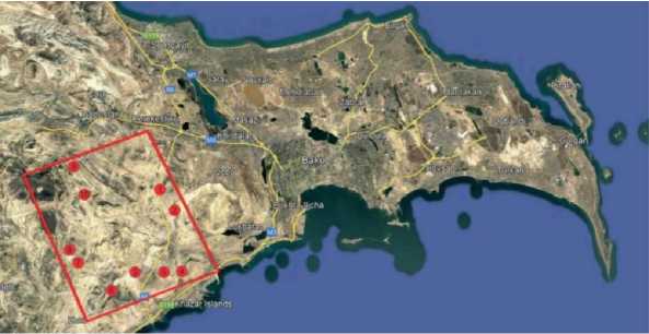
Figure 1. Location of the research area
The spatial configuration of the study area demonstrates that mud volcanoes are not randomly distributed but rather aligned along structural lines associated with deep-seated tectonic faults. This observation is consistent with previous studies conducted in Azerbaijan, which emphasize the relationship between mud volcanism and hydrocarbon-bearing sedimentary basins [2, 3] .
The analyzed volcanoes form a representative cluster within the Absheron-Gobustan geomorphological region, which is globally recognized as one of the most active mud volcanic provinces.
Table
AREA OF MUD VOLCANOES LOCATED IN THE RESEARCH AREA
|
Name of mud volcanoes |
Area covered by mud volcanoes (hectares) |
|
Shorbulag |
584.62 |
|
Gulbakht-Sarinja |
180 |
|
Pilpili Garadag |
12 |
|
Garadag Akhtarma |
107.07 |
|
Torpagli Akhtarma |
224.73 |
|
Otman-Bozdag |
1061.54 |
|
Shahgaya |
99.91 |
|
Chapilmish |
107.13 |
|
Kirdag |
271.97 |
|
Buransiz-Chulga |
24.68 |
From a morphometric perspective, the studied mud volcanoes exhibit significant differences in areal extent. As presented in Table, Otman-Bozdag (1061.54 ha) represents the largest structure, while Pilpili Garadag (12 ha) and Buransiz-Chulga (24.68 ha) are comparatively smaller formations. These differences are indicative of varying eruption intensities, durations, and sediment accumulation processes. Larger mud volcanoes such as Otman-Bozdag and Kirdag are characterized by more complex cone systems and extensive mud flow deposits, whereas smaller volcanoes tend to exhibit simpler morphologies.
The elevation analysis of the study area reveals a wide altitudinal range from approximately – 21 m (below sea level) to 436 m, particularly in the vicinity of Otman-Bozdag and Kirdag mud volcanoes. This variation highlights the geomorphological diversity of the region. According to DEM-based classification, 11% of the area lies below sea level, 34% falls within the 0–100 m range, 41% within 100–250 m, 13% within 250–350 m, and only 1% exceeds 350 m. (Figure 2.)
This distribution clearly indicates the dominance of lowland and slightly elevated terrains, which are typical for mud volcano environments. The presence of below-sea-level areas is particularly significant, as it reflects the influence of the Caspian Sea basin and ongoing subsidence processes. Such conditions contribute to the formation of specific sedimentary environments favorable for mud volcanism. Similar geomorphological settings have been reported in global mud volcanic regions confirming the consistency of the observed patterns [3, 6].
A more detailed spatial analysis shows that individual mud volcanoes occupy different elevation zones, which directly affects their morphological and ecological characteristics. For instance, Shorbulag, Pilpili Garadag, and Torpagli Akhtarma are predominantly located within the 0–100 m elevation range, indicating their association with coastal and lowland plains. These areas are typically characterized by weakly developed relief, fine-grained sediments, and higher salinity levels. In contrast, Otman-Bozdag and Kirdag are situated within higher elevation zones (250–350 m and above), where more pronounced relief forms and steeper slopes can be observed.
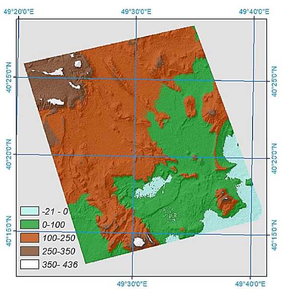
Figure 2.Relief description of the research area
The geomorphological structure of the study area is largely dominated by abrasion-accumulative and abrasion-deflation plains. These landforms are formed under the combined influence of marine, aeolian, and denudational processes. The abrasion-accumulative plains are primarily associated with coastal dynamics, where sediment deposition and wave action interact, while abrasion-deflation plains reflect the role of wind erosion and surface deflation in shaping the landscape. This geomorphological framework plays a crucial role in controlling the spatial distribution of soils and vegetation. In areas dominated by deflation processes, fine particles are removed, leading to the exposure of clayey substrates and the formation of barren surfaces. These conditions are particularly evident around smaller mud volcanoes such as Pilpili Garadag and Buransiz-Chulga, where vegetation cover is extremely sparse. The slope analysis provides further insight into the terrain characteristics of the study area. The results indicate that 65.8% of the territory consists of very gentle slopes (0°–5°), 20.5% falls within 6°–10°, 7.4% within 11°–15°, 4.8% within 16°–25°, and only 1.5% represents steep slopes (26°–53°). (Figure 3).
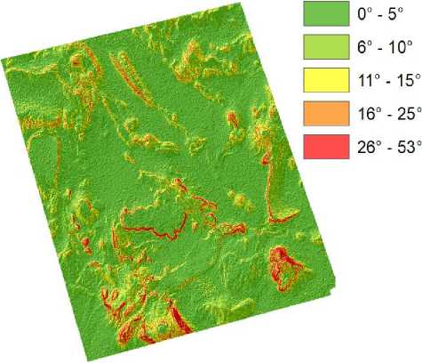
Figure 3. Slope description of the research area
The predominance of gentle slopes confirms that the study area is largely characterized by flat and slightly undulating terrain. This has important implications for both geomorphological processes and ecological conditions. Gentle slopes favor the accumulation of fine sediments and salts, contributing to soil salinization and limiting vegetation growth. On the other hand, steeper slopes, although limited in extent, are mainly associated with larger mud volcano structures such as Otman-Bozdag and Kirdag, where cone formation and mud flow processes create more pronounced relief features. The relationship between slope and erosion processes is also evident in the study area. Gentle slopes are generally associated with low erosion rates but high accumulation potential, whereas steeper slopes are more susceptible to erosion and mass movement processes. This dynamic interplay between erosion and accumulation significantly influences the spatial heterogeneity of the landscape.
At this stage of analysis, it is important to emphasize that the obtained results are not only based on remote sensing data but also reflect realistic field conditions. The interpretation of DEM and satellite imagery allows for the identification of microrelief features, drainage patterns, and surface textures, which are critical for understanding the functioning of mud volcano ecosystems.
The ecological and geomorphological characteristics of the selected mud volcanoes demonstrate considerable spatial variability, which reflects the influence of local relief conditions, lithological composition, and surface processes. A detailed analysis of each mud volcano allows for a more precise understanding of landscape differentiation within the study area.
Shorbulag mud volcano, covering an area of 584.62 hectares, is located within the lowland zone (0–100 m) and is characterized by relatively flat terrain and weakly expressed relief forms. The dominance of gentle slopes in this area facilitates the accumulation of fine sediments and salts, leading to the development of saline and weakly structured soils. As a result, vegetation cover is extremely sparse and mainly represented by halophytic and xerophytic plant species. The ecological conditions observed in Shorbulag are typical for coastal semi-desert environments and are consistent with findings reported in regional studies on the Absheron Peninsula [2].
Gulbakht-Sarinja mud volcano (180 ha) is situated within the 100–250 m elevation range, where slightly more developed relief forms can be observed. The transition from lowland to elevated terrain creates more favorable conditions for soil differentiation and partial vegetation development. Compared to Shorbulag, this area exhibits a higher degree of geomorphological complexity, including small ridges and depressions formed by mud flow processes. These features contribute to the formation of microhabitats, which support limited but more diverse vegetation cover. Similar patterns have been described in semi-arid mud volcanic regions, where microrelief plays a key role in ecological variability [1].
Pilpili Garadag mud volcano, despite its small size (12 ha), represents an important example of a compact mud volcanic structure. It is located in the 0–100 m elevation zone and is characterized by minimal vegetation and exposed clayey surfaces. The dominance of deflation processes in this area results in the removal of fine particles and the formation of barren landscapes. The ecological conditions are therefore extremely harsh, limiting biological productivity. Such environments are often considered analogues of extreme terrestrial ecosystems, where only highly adapted species can survive.
Garadag Akhtarma (107.07 ha) demonstrates a more balanced combination of geomorphological and ecological features. Located within the 100–250 m elevation range, this volcano is associated with moderately developed relief and relatively stable surfaces. One of the distinguishing characteristics of this area is the presence of localized vegetation patches, which are more pronounced compared to other volcanoes in the study area. This can be explained by relatively lower salinity levels and improved soil structure, which allow for limited plant colonization.
Torpagli Akhtarma (224.73 ha), situated in the lowland zone, exhibits characteristics similar to Shorbulag but with slightly more pronounced relief features. The area is dominated by saline gray soils and clayey substrates, which significantly restrict vegetation development. However, the presence of microdepressions allows for temporary moisture accumulation, creating localized ecological niches.
Otman-Bozdag mud volcano, the largest in the study area (1061.54 ha), represents the most complex geomorphological system among the analyzed sites. It is located within higher elevation zones (250–350 m and above), where more pronounced slopes and relief contrasts are observed. The large size and structural complexity of this volcano are associated with long-term eruptive activity and extensive mud flow deposits.
From an ecological perspective, Otman-Bozdag supports relatively more developed vegetation compared to other mud volcanoes. This is due to the presence of more stable surfaces, reduced salinity in certain areas, and increased moisture retention capacity. These conditions allow for the formation of semi-natural plant communities, which play an important role in stabilizing the surface and preventing erosion. The significance of such vegetation in semi-arid environments has been highlighted in recent studies focusing on land degradation and ecosystem resilience.
Shahgaya (99.91 ha) and Chapilmish (107.13 ha) mud volcanoes exhibit intermediate characteristics in terms of both geomorphology and ecology. They are located within the 100–250 m elevation range and are characterized by moderate slopes and mixed soil conditions. The combination of saline and non-saline soils creates a mosaic landscape, where vegetation distribution is highly uneven. These areas illustrate the transitional nature of ecological conditions within the study area.
Kirdag mud volcano (271.97 ha), similar to Otman-Bozdag, is located in a higher elevation zone and is characterized by more pronounced relief features. The slope gradients in this area are relatively higher, which increases the intensity of erosion processes. However, the presence of stable surfaces in certain parts allows for the development of vegetation patches. The interaction between erosion and vegetation dynamics in Kirdag represents an important aspect of landscape evolution in mud volcanic regions.
Buransiz-Chulga (24.68 ha), one of the smallest mud volcanoes in the study area, is characterized by simple morphology and extreme environmental conditions. The area is dominated by bare surfaces and saline soils, with almost no vegetation cover. This makes it a representative example of highly degraded mud volcanic landscapes.
The analysis of soil cover across the study area reveals a predominance of saline and semisaline soils, which significantly influence ecological conditions. Approximately 40% of the area is covered by saline gray and gray-brown soils, while 38.5% consists of light and primitive gray soils. Grass-gray soils account for 16.5%, whereas nodular sandy formations (2.8%) and bare rock or exposed clayey surfaces (2.2%) occupy smaller proportions. (Figure 4).
The high degree of soil salinity is one of the key limiting factors for vegetation development. Saline soils reduce water availability for plants and create osmotic stress, which restricts plant growth and distribution. As a result, vegetation in the study area is sparse and mainly composed of halophytic and xerophytic species adapted to arid conditions. These findings are consistent with ecological studies conducted in arid and semi-arid regions of Azerbaijan [7].
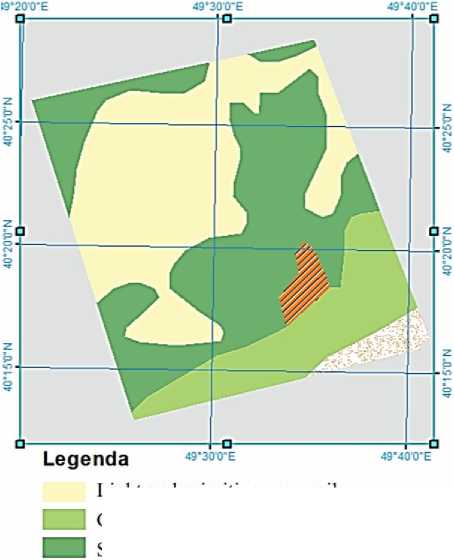
Light and pnmitive gray soils
Grass-gray soils
Saline gray and gray-brown soils
Nodular sandy formations в Bare rock or exposed clayey surfaces
Figure 4. Soil map of the research area
Vegetation distribution is closely related to both soil properties and geomorphological conditions. Areas with relatively lower salinity and more stable surfaces, such as Garadag Akhtarma, Otman-Bozdag, and Kirdag, exhibit higher vegetation density. In contrast, areas with active mud flows, high salinity, and unstable substrates show minimal or no vegetation cover. The vegetation cover of the study area is characterized by semi-desert and dry-steppe conditions, with hot summers and mild winters. Due to the combined influence of relief, soil salinity, and arid climate, vegetation distribution is highly limited and spatially discontinuous. The dominant plant communities consist mainly of xerophytic and halophytic species, including desert and semi-desert vegetation, as well as psammophytic and littoral plant formations observed in coastal sandy areas [12].
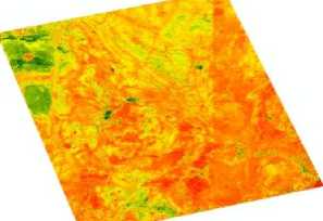
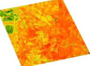
Vegetation is primarily concentrated in specific locations, particularly in the surroundings of larger mud volcanoes such as Garadag Akhtarma, Otman-Bozdag, and Kirdag, where relatively more favorable microrelief and soil conditions allow partial plant development. A comparative analysis of satellite imagery based on the Normalized Difference Vegetation Index (NDVI) for the years 2016, 2019, and 2023 indicates a noticeable decline in vegetation density over the observed period. This trend suggests that recent climatic changes and increasing aridity have contributed to the degradation and thinning of vegetation cover within the study area (Figure 5).
Date: 28 June 2016
Date: 23 August 2019
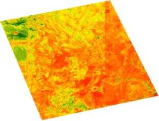
Figure 5. Comparative NDVI maps of the study area for 2016, 2019, and 2023
Date: 12 August 2023
Furthermore, the climatic conditions of the study area-characterized by semi-desert and drydesert climate with hot summers and mild winters play a crucial role in shaping ecological patterns. Low precipitation and high evaporation rates contribute to soil salinization and limit vegetation growth. The interaction between climate, soil, and relief creates a fragile ecological system that is highly sensitive to environmental changes.
The integrated analysis of geomorphological, soil, and vegetation characteristics within the study area reveals that mud volcano landscapes represent highly specialized and spatially heterogeneous systems shaped by the interaction of endogenous and exogenous processes. The results obtained from DEM-based analysis, slope classification, and soil mapping confirm that the distribution and ecological features of the selected mud volcanoes are strongly controlled by elevation gradients, terrain morphology, and salinity conditions. One of the key findings of this study is the dominance of lowland and gently sloping terrains, which occupy the majority of the research area. These conditions favor sediment accumulation and salt concentration, leading to the formation of saline and weakly developed soils. As a consequence, vegetation cover remains sparse and discontinuous across most of the territory. This pattern is typical for semi-arid mud volcanic environments and has been widely documented in similar regions [9].
At the same time, the presence of localized elevated areas, particularly around Otman-Bozdag and Kirdag mud volcanoes, introduces significant geomorphological and ecological variability. These areas are characterized by steeper slopes, more active erosion processes, and relatively better- developed soils. As a result, they support more stable vegetation cover compared to surrounding lowland areas. This demonstrates that even within predominantly arid environments, small variations in relief can lead to noticeable differences in ecological conditions.
Another important aspect revealed by the study is the strong relationship between soil salinity and vegetation distribution. The predominance of saline gray and gray-brown soils significantly limits plant growth by reducing water availability and increasing osmotic stress. Only highly adapted halophytic and xerophytic species are able to survive under such conditions. However, in areas where salinity is relatively lower and soil structure is more developed, vegetation density increases, forming patchy but ecologically significant plant communities.
The comparative analysis of the ten mud volcanoes shows that larger and morphologically more complex structures, such as Otman-Bozdag and Kirdag, play a crucial role in enhancing landscape diversity. Their extensive mud flows, varied microrelief, and relatively stable surfaces create a range of ecological niches. In contrast, smaller volcanoes such as Pilpili Garadag and Buransiz-Chulga are characterized by extreme environmental conditions and minimal ecological diversity.
The findings of this study also highlight the importance of microrelief in shaping ecological patterns. Even minor variations in elevation and slope can influence moisture retention, soil formation, and vegetation distribution. This emphasizes the need for high-resolution spatial analysis in the study of mud volcanic landscapes. From a broader scientific perspective, the results obtained in this research are consistent with global studies on mud volcanism and arid landscape ecology. According to Giuseppe Etiope et al., mud volcanoes are key indicators of subsurface geological processes and play an important role in methane emissions and environmental dynamics. Similarly, studies on semi-arid ecosystems underline the sensitivity of such landscapes to climatic and anthropogenic changes. In addition, the results of this research are in agreement with the findings presented in previous regional studies, including the author's earlier work on the ecogeographical characteristics of vegetation in mud volcano areas [12].
The consistency between these studies confirms the reliability of the applied methodology and highlights the importance of integrating GIS-based analysis with ecological interpretation.
The obtained results also have important practical implications. The identification of areas with relatively stable ecological conditions and higher vegetation potential can support land management and conservation planning within the Mud Volcanoes Group State Nature Reserve. Furthermore, understanding the spatial variability of landscape components is essential for assessing the potential of the area for geopark development. Finally, it should be noted that mud volcano landscapes are highly dynamic systems that can change rapidly due to both natural processes and human impact. Therefore, continuous monitoring using remote sensing and GIS technologies is necessary to ensure sustainable management and conservation of these unique natural complexes.
Suggestion and conclusions
The results of this study demonstrate that mud volcano landscapes within the Mud Volcanoes Group State Nature Reserve are characterized by pronounced geomorphological and ecological heterogeneity, primarily controlled by relief, soil salinity, and climatic conditions. The dominance of lowland and gently sloping terrains способствует the accumulation of saline sediments, which significantly limits vegetation development.
The analysis confirms a strong interdependence between geomorphological parameters and vegetation distribution. Areas with relatively higher elevations, more stable surfaces, and lower salinity levels such as Otman-Bozdag and Kirdag support comparatively denser vegetation cover, whereas smaller and morphologically simpler mud volcanoes are associated with extreme environmental conditions and minimal biological productivity.
NDVI-based assessment reveals a declining trend in vegetation density over the period 2016– 2023, indicating the increasing influence of aridity and climate variability on ecosystem dynamics.
Overall, the study highlights the importance of integrating GIS and remote sensing approaches for understanding spatial patterns and temporal changes in semi-arid mud volcano environments. The findings provide a scientific basis for environmental management, conservation planning, and future geopark development in the region.
