Engineering and geological zoning of the residual soil of the Malmyzhsky deposit (Svoboda site)
")
Author: Abaturova I.V., Bobina T.S.
Journal: Вестник Пермского университета. Геология @geology-vestnik-psu
Section: Инженерная геология, мерзлотоведение и грунтоведение
Article in issue: 2 т.20, 2021.
Free access
Interest to the study of residual soil arose at a time when geological engineers faced the problem of developing the open pits in the eluvial soils. A significant number of Russian and foreign scientists considered the formation of weathering crusts from different points of view. They established the geochemical zoning, and engineering-geological zoning of the weathering crusts. However, no comprehensive and detailed engineering-geological zo-nation of the crusts of weathering, especially when studying mineral deposits, was given due to the insufficient attention paid to it until today. Therefore, it is important to correctly determine the type and profile of the residual soil in order to establish the possibility to control the engineering and geological conditions when exposing the rock mass during excavation work for further forecasting the slope stability of the projected open pit mining structures.
Residual soil, parent rock, engineering-geological zoning of the weathering crust, thickness of the weathering crust, weathering profile, physical and mechanical properties of rocks, malmyzhskoe gold-copper-porphyry deposit
Short address: https://sciup.org/147246208
IDR: 147246208 | UDC: 551.3.053+553.068.36 | DOI: 10.17072/psu.geol.20.2.150
Инженерно-геологическая зональность кор выветривания Малмыжского месторождения (участок Свобода)
Интерес к изучению кор выветривания появился в момент, когда инженеры-геологи столкнулись с проблемой ведения отработки карьеров, сложенных элювиальными грунтами. Значительное количество российских и зарубежных ученых рассматривали формирование кор выветривания с различных позиций. Ими были установлены геохимическая зональность и инженерно-геологическая зональность кор выветривания. Однако, точному и детальному расчленению кор выветривания на инженерно-геологические зоны, особенно при изучении месторождений полезных ископаемых, не уделяется должное внимание и на сегодняшнее время. Поэтому важно на момент проведения геологоразведочных работ правильно определить тип и профиль коры выветривания, установить возможности изменения инженерно-геологических условий при вскрытии массива пород горными выработками для дальнейшего прогноза устойчивости стенок и бортов проектируемых горнорудных сооружений.
Text of the scientific article Engineering and geological zoning of the residual soil of the Malmyzhsky deposit (Svoboda site)
The study of residual soil provides with the important information on the composition and evolution features of the lithosphere, the formation of new clayey soils types, which can be used for construction of the foundations of various types of structures: from buildings to quarries. Therefore, it is important at the stage of exploration to correctly assess the engineering and geological conditions of the object, including the features and patterns of distribution of weathering crusts.
The residual soil (r.s.) is an unusual lithological complex. Most of them are loose ocher-clayey formations that inherit the structural pattern of the parent rocks, and turn into unaltered rocks with depth. The lithological composition, the nature of the clayey weathering products, and their physical and mechanical properties change dramatically depending on the composition of the parent rocks. It is important to note that, for any sections, a distinct zoning, which is reflected in a certain successive change of source rocks alteration upward the section is required. The mineral and lithological composition of these zones depends on the petrographic composition of the source rocks, the type of weathering, and the sequence of superposition of weathering processes of different nature. In addition, the degree of rock fracturing has a significant impact on the development of the weathering process. The more fractured the rock, the easier it is to weather.
All the above contributes to the uneven course of the process of weathering crust formation. In the fractured zones, irregular, pocketlike depressions, sheet-like deposits, and often going to considerable depth vein-like bodies appear. As a result, the bottom of the weathering crust has a complex, winding surface, consisting of varying ridges and depressions of different directions.
In the engineering-geological study and assessment of mineral deposits, the weathering crust forming the upper horizons of the lithosphere is one of the components of the engineering-geological conditions that affect the development of large-scale engineering-geological processes in the slopes of open pits, because they often reach hundreds of meters of depths.
We consider one of the examples of deposits, which upper part of geological section is composed of weathering crusts.
Materials and Methods
In Russia, methodological aspects of obtaining information on the vertical structure of the weathering crust, its state, physical and mechanical properties are standard and are reflected in the works of N.V. Kolomenskiy (1952), G.S. Zolotarev (1971), V.B. Shvets et al. (1970), I.V. Abaturova et al. (1987), V.N. Razumova et al. (1963), L.A. Yarg (1991). The methodology of complex work includes engineering-geological documentation of well core, sampling, laboratory study of samples.
In her works, L.A. Yarg (1983), presented all the obtained results that allow creating unified classification, where she identified zones and subzones of the weathering crust, and characteristic features for each of them.
Only since 1950, the foreign geologists began to pay considerable attention to the characteristics of eluvial soils and their engineering properties, as well as to make attempts to develop classification schemes for rocky soils subjected to weathering processes. The classification of weathering crusts was based on the scheme of weathered rocky igneous soils. D.G. Moye ( 1955) , identified the engineering properties of weathered rocky soils and identified six degrees (classes) of weathering the bedrock with depth.
However, there is currently no unified classification in foreign geology. Some geological engineers (Irfan, 1996, Momeni et al. 2015, Bucher et al., 2015, etc.) use an individual quan- titative indicator of any property (e.g. the percentage of weathered soils, the value rebound of Schmidt s hammer, porosity, etc.). Others use qualitative classification schemes, which are based on observational descriptions and some simple indicators of properties (e.g. the description of changes in structure, texture, color of weathered soils (Farkas et al., 2018; Martin et al., 2020; Patel, 2017).
In parallel, with the accumulation of information on the structure of weathering crusts, foreign and our scientists studied the changes in the physical and mechanical properties of soils along the weathering profiles, and the reasons for their change. Using results of field and laboratory studies, the mechanisms of changes in the strength and deformation parameters of soils from bedrocks to eluvial clay formations were revealed.
Results of work
The Malmyzhskoye gold-copper-porphyry deposit is located within the Khabarovsk Territory. It consists of three large areas: Dolina, Svoboda, Center – differing from each other in the petrographic composition of the source rocks, tectonic disturbance, and the degree of development of chemical weathering.
Svoboda site. The predominant rocks of the Svoboda area are the quartz-diorite porphyrites with minor xenoliths of silty sandstones and magmatic breccias (fig. 1).
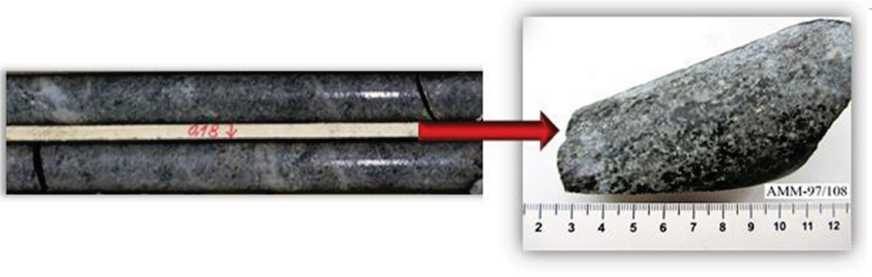
Fig. 1. Source rocks of the Svoboda site (quartz-diorite porphyrites)
The multiphase nature of the formation of source rocks, repeatedly experienced the tectonic impact, and ore formation processes with the introduction of easily oxidizable minerals pre- pared the massif for the active penetration of weathering agents, and the formation of areal and linear weathering crusts. The formation of linear weathering crusts is associated with the contact zones of quartz-diorite porphyrites with silty sandstones and magmatic breccias. In addition, the development of weathering crusts also contributed to neotectonic movements, leading to the cataclasis of rocks. Depending on the degree of fragmentation and cataclasis, the depth of weathering increases to 70–100 meters.
The field is characterized by a relationship between the capacity of the weathering crusts and:
-
1. The mineral composition of the parent rocks. The presence of rapidly oxidizing copper minerals (pyrite, chalcopyrite, galena, sphaler-
- ite, arsenopyrite) indicates the feasibility of penetrating the weathering process to greater depths. This is due to the oxidation of the above mentioned minerals, which causes the formation of sulfuric acid and an increase in the chemical weathering – CuFeS2 + H2O + O2 = Fe2O3 + H2SO4 + Cu (chalcopyrite + water + molecular oxygen = hematite + sulfuric acid + copper);
-
2. Geomorphological conditions (fig. 2). In low elevation areas and places, where magmatic breccias and silty sandstones are developed, weathering crusts achieve the greatest thickness (up to 100 m) as noted.
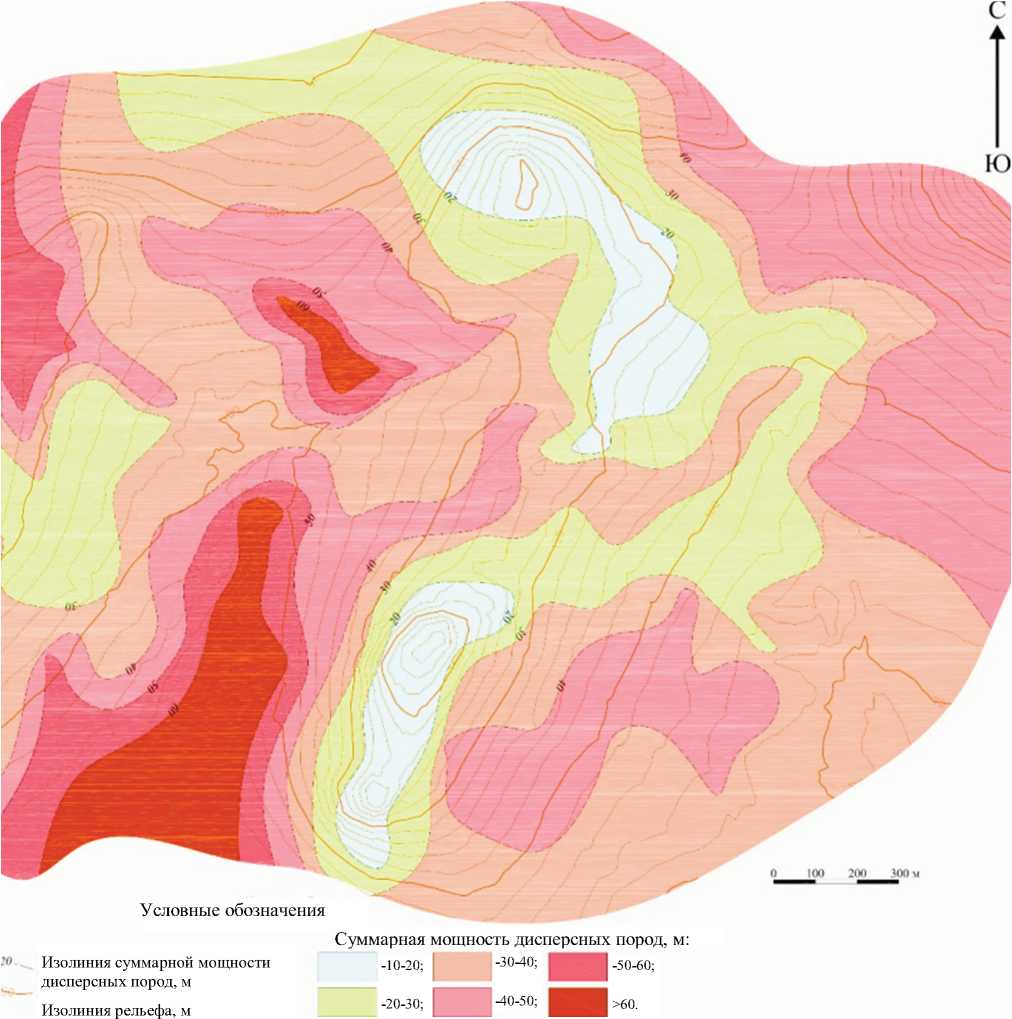
Fig. 2. Diagram of the thickness of the residual soil of the Malmyzhskoye field (Svoboda site)
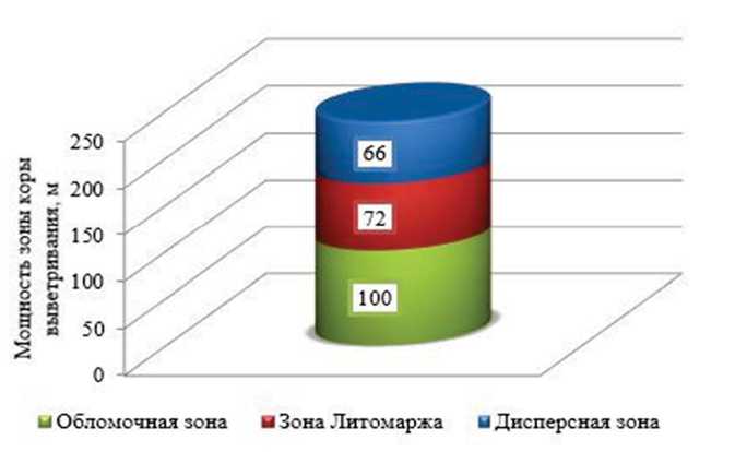
Fig. 3. Profile of the residual soil of the Svoboda site
Weathering of quartz-diorite porphyrites occurs due to hydration, removal of bases and silicic acid, and oxidation of ferrous iron. As a result, the final products of weathering are enriched in free oxides of Fe, Al, and Ti. However, each of the weathering zones has its own, inherent only in it, chemical transformations of the initial material.
The weathering profile along quartz-diorite porphyrites of the Svoboda site has a zonal structure (fig. 3). According to the engineering-geological classification of L.A. Yarg ( 1974) , the weathering crust is divided into 3 zones (bottom-up):
-
1. Clastic (gravelly subzone)
-
2. Lithomarge
-
3. Dispersed (clayey subzone)
Clastic zone
The clastic zone is represented by a rubble subzone, which differs a little from unaltered weathered rocks. Plagioclase and quartz, as the main components of the parent rocks in it, remain practically unchanged that is not observed in hornblende, which begins to hydrate transforming into hydrochlorites. Due to the increase in hydrochlorites, disintegration and loosening of the rock occur (fig. 4).
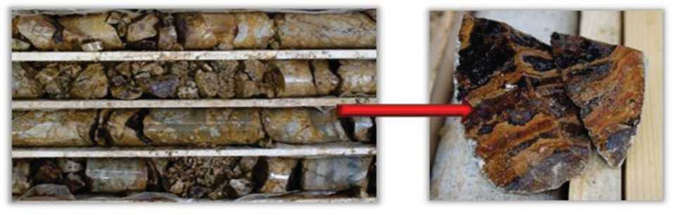
Fig. 4. Rubble zone of residual soil
A distinctive feature of the clastic zone of the Svoboda ore zone is the presence of iron hydroxides, which are associated with a high content of easily oxidized minerals in the parent rock.
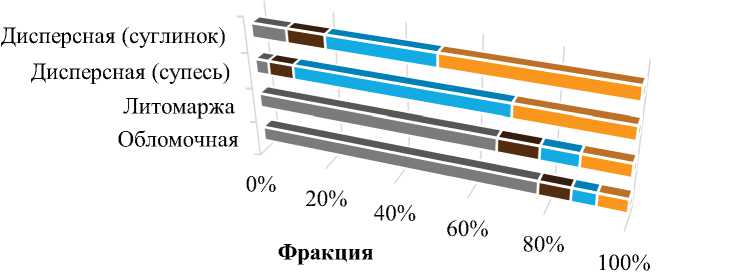
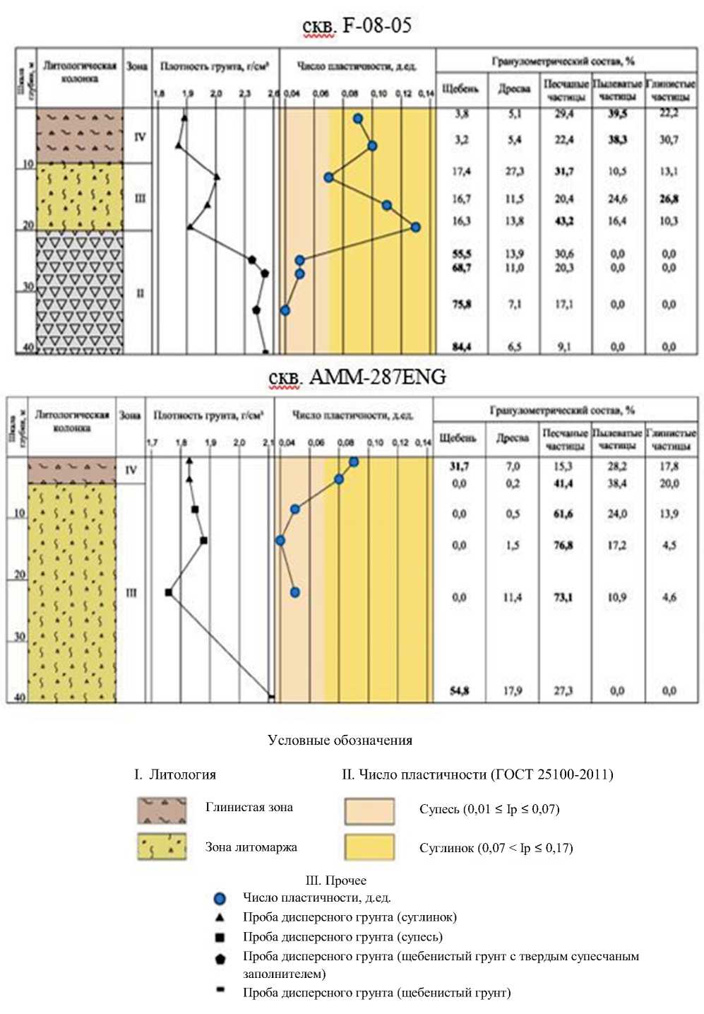
From the point of view of engineering and geological features, the clastic zone is a crushed rock with the following fractions content: crushed stone – 77.4 %, gravel – 8.4 %, coarse sand – 6.4 %, fine sand, dust and clays – 7.8 % (fig. 5).
Зона коры выветривания
■ щебень ■ дресва ■ крупный песок ■ мелкий песок+пыль+глина
Fig. 5. Granulometric composition of the rock by zones of the residual soil (by quartz diorites)
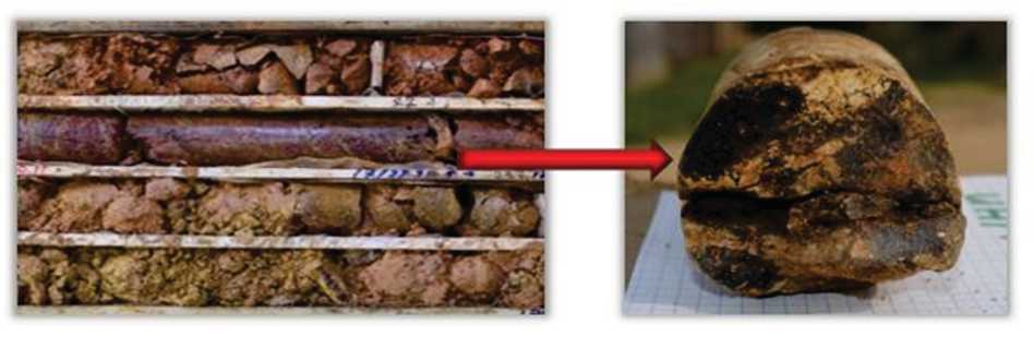
Fig. 6. Crushed stone with sandy loam aggregate in the Lithomarge zone
The density of the fragments is 2.42 g / m3, and strength of the fragments is equal to the average value.
The following values of the physical and mechanical properties of rubble soil correspond to this zone:
-
• natural humidity W varies from 0.006 to 0.391 CU. with an average value of 0.141;
-
• deformation modulus E is in the range of 48.5-55.3 MPa;
-
• the average value of the specific cohesion was C = 0.006 MPa;
-
• angle of internal friction φ0 = 34.
The exposed capacity of the zone is 100 meters.
Lithomarge zone
The most difficult to study and hazardous for the stability of the rock mass is the Lithomarge zone. In this zone, changes in the structure, texture and nature of structural bonds begin to manifest themselves. Here, further hydration of chlorites and kaolinization of plagioclases, leaching of Ca, Na, and silicas that are part of plagioclases occur. Active oxidation processes take place forming randomly located spots of varying color intensity (fig. 6).
From the point of view of engineering and geological features, the Litomarzh zone is composed of crushed stone or gruss with loamy filler, and in areas of increased silicification with sandy loam filler. By granulometric composition, the aggregate is light dusty (fig. 5).
Fragments in the form of crushed stone, gruss, and sometimes lumps have different strengths from low to small with Rc = 1–5 MPa. Aggregate loam with plasticity number Ip = 0.07–0.15 c.u. with an average value of 0.10 CU, sandy loam with Ip 0.03–0.07 CU, with an average value of 0.05 CU.
By changing some properties of the soil, it is possible to determine the transitional boundary between this and clastic zone: during the transi- tion, the natural moisture content W sharply increases – from 0.141 to 0.186 unit and specific clutch C – reaches 0.013 MPa. The angle of internal friction is reduced to 30°. This indicates the presence of clay minerals.
The thickness of the zone reaches about 72 meters.
Disperse zone
Upward the profile, a dispersed zone (clayey subzone of the weathering crust) appears. In this zone, the original rocks experience the final processes of oxidation and transformation, and the formation of clay minerals (kaolinite, montmorillonite, etc.) begins. This zone is rather widespread and is represented by variegated clay soils with ocher, sometimes white spots (fig. 7). The structure and texture of the source rocks, as well as relict fracturing are quite clearly expressed. The thickness of the zone varies from 0.2 m to 66.0 m.
From the point of view of engineering and geological description, the dispersed zone is represented by sandy loam and loam with inclusions of gruss and crushed stone. Loam ranges from light brown to dark brown in the color. Granulometric composition (fig. 5):
-
• sandy loam – clay fraction is 9.1 %, silty – 17.3 %, sandy 44.9 %;
-
• loam – clay fraction is 33 %, dusty – 22 %, sandy – 21 %, gritty – 11 %, gravelly – 6 %.
There are severely weathered sharply-angled fragments ranging in size from 0.2 to 7 cm. Films of iron and manganese hydroxides are observed along the fractures of the fragments, and intense hematitization occurs (fig. 8).
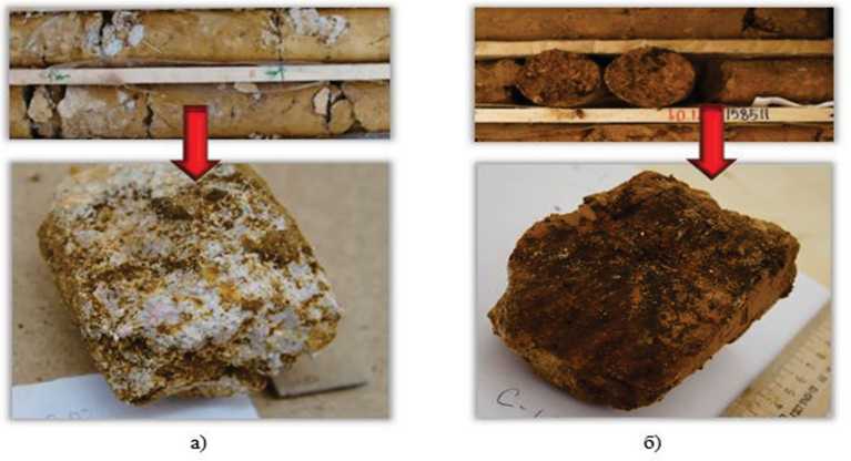
Fig. 7. Dispersed zone of the residual soil with preservation of the structure and relict cracks: a) sandy loam; b) loamy
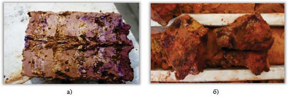
Fig. 8. Sample of the dispersed zone of the residual soil with films manganese (a) and iron hydroxides (b)
Tab. 1. Physical and mechanical properties of different zones of the residual soilof the Svoboda site
|
Propertyindicators* |
Weatheringcrustzone |
|||
|
Dispersed(sandy loam) |
Dispersed(loam) |
Litomarge |
Detrital |
|
|
Naturalmoisture,W,d.u. |
0.160 |
0.191 |
0.186 |
0.141 |
|
Moistureatpourpoint,W L ,d.u. |
0.242 |
0.335 |
0.338** |
0.367** |
|
Moistureatrollingedge,W P ,e. |
0.192 |
0.233 |
0.258** |
0.305** |
|
PlasticitynumberIp,unitfraction |
0.05 |
0.10 |
0.08** |
0.06** |
|
IndexoffluidityI L ,unitfraction |
-0.71 |
-0.42 |
-0.69** |
-0.68** |
|
Soildensityp,g/cm3 |
1.82 |
1.92 |
- |
- |
|
Debrisdensityp,g/cm3 |
- |
- |
2.38 |
2.42 |
|
Densityofsoilparticles,ps,g/ cm3 |
2.55 |
2.51 |
2.50 |
2.59 |
|
Densityofdrysoil,pd,g/cm3 |
1.57 |
1.62 |
- |
- |
|
Porosity,n,% |
39 |
36 |
- |
- |
|
Porositycoefficient,e,unitfrac-tion |
0.63 |
0.56 |
- |
- |
|
Watersaturationcoefficient,Sr, unitfraction |
0.65 |
0.86 |
- |
- |
|
FiltrationcoefficientKf,m/day |
0.05 |
0.02 |
- |
- |
|
Relativeswellingdeformation withoutload, □sw0,d.u. |
- |
0.05 |
- |
- |
|
Internalfrictionangle,φ° |
23 |
20 |
30 |
34 |
|
Specificadhesion,С,MPa |
0.029 |
0.044 |
0.013 |
0.006 |
|
Ultimateresistancetouniaxial compression,Rszh,MPa |
- |
- |
5*** |
12*** |
Note:forgrittyloams,withgritandcrushedstone,thevaluesoftheangleofinternalfriction,specificadhe-sionanddeformationmodulusaregiveninaccordancewiththe«Methodologyforassessingthestrengthand compressibilityofcoarsesoilswithsiltyandclayfillersandsiltandclaysoilswithcoarseinclusions.DalNI-ISGosstroyUSS.Moscow,1989».*Meanvalue.**Valuesforplaceholder.***Valuesforwreckage.
Comparingthephysicaland mechanical propertiesofthesoilofthedispersedzonewith thepropertiesofthesoiloftheabovezones showsthat theprocess of modificationofthe initialstrongparentrocks,andtheformationof clayminerals, which alreadyhavelower strengthcharacteristics,canbeclearly identi-fied.Sointhiszone,thedensityofthesoil equalto1.92g/cm3,naturalhumidityreaches maximum values–0.252CU,aswellasthe specificadhesionC=0.044MPa.Theaverage valueofthedeformation modulusEfallsto 4.5MPa.Theangleofinternalfrictionφ0=20. Allthesecharacteristics indicatethatdispersed zoneoftheweatheringcrustisunstableduring theformationandoperationoftheslopesofthe quarrieslocatedintheserocks.
Belowisacomparativetable1ofthephysi- calandmechanicalpropertiesofrocksindiffer-entzonesoftheweatheringcrustandgraphsof changesinsomeproperties(fig.5,9).
Conclusion
TheSvobodasite oftheMalmyzhskoye gold-copper-porphyrydepositispartofthenat-uralsystem,which,prior to thestart ofdevel-opment,interactedwithasysteminfluencedby alargeandcomplexsetofengineeringandgeo-logicalfactors.Theequilibriumofthissystemis dynamicanddependsonthedevelopmentof engineering-geologicalprocessesthatcharacter-izethegeodynamicsituationanddeterminethe degreeofstabilityoftherockmasstoexternal influences,aswellasthetypeandscaleofthe upcomingchanges.
20.4
Условные обозначения скв. F-08-05
II. Число пластичности (ГОСТ 25100-2011)
Супесь (0,01 ≤ Ip ≤ 0,07)
I. Литология
III. Прочее о Число пластичности, д.ед.
л Проба дисперсного грунта (суглинок)
■ Проба дисперсного грунта (супесь)
• Проба дисперсного грунта (щебенистый грунт с твердым супесчаным заполнителем)
ж Проба дисперсного грунта (щебенистый грунт)
Глинистая зона
Зона литомаржа
Суглинок (0,07 < Ip ≤ 0,17)
СКВ. AMM-287ENG
I р<му.юмстр«пскш* соспа, Ч
Ихпяостъ
Нымшпм
Я.?
Г .ши нет we честжцы
Несшим мстамм
7VWW^ 'VVVVVV 7WWVS 'WWW ^^vvvvv^
WWW 7WWV\ WWW „7VV7VV5 .И*г7ттгггтт7т71
|
Идол UB 1 |
ЮСТЪ г • 1 |
П”». 9 1 |
г ex’ 1 V |
Чж 0.0* |
хо ив ме |
спгак 10« |
жтк д МО 0 |
<А и aw |
II We»».
Чино luacnrowra. дм
|
ЮЛОШВ |
1 |
7 1 |
4 1 |
» I |
0 V |
Ml |
ме |
3.» |
14 0,11 IM |
UWnu |
Дреем |
Идейные ем I ■ - |
Пм-осаатис мспщы |
. ■■■. м 4*0 мим |
|||
|
10 JO |
b ^ A ^ A ^ ’s Л •’$ i • $ • $ 1 • 1 • s V V ' J • 1 • 1 .• h* V ’ $ • 1 • $ i • I • i .• V V 1 $ • 5 ‘ 5 • 4 4 • |
IV III |
JI.7 0.0 0.0 0.0 0.0 МЛ |
7.0 од ад и ПЛ ПЭ |
153 41,4 «14 ?М ЯД 273 |
2U МЛ 24.0 П.2 10.9 0.0 |
ПЛ 20,0 m 4J 4.6 0.0 |
||||||||||
Engineering and geological study of the section of the weathering crust was carried out according to a set of parameters including: structural and textural features, mineral composition, physical and mechanical properties of rocks. Three zones were identified at the Malmyzh-skoye field (Svoboda Site): IV – dispersed, III – Litomarzha, and II – clastic.
The thickness of the weathering crust varies significantly reaching maxima in tectonic zones, as well as in zones where the contact of different rocks predetermined the presence of geochemical barriers.
An analysis of the physical and mechanical properties of the weathering crust rocks proves that the change in geological conditions within even one zone of the c.v. the Malmyzhskoye gold-copper-porphyry deposit (Svoboda Site) entails a change in the choice of projected pit slope angles. Therefore, it is necessary at the initial stages of the deposit study (period of exploration work), the sides of which will be folded by weathering crusts, to study in detail the characteristic features of the rocks that are inherent in them, taking into account their possible changes during the operation of the deposit. Acknowledgments/ The authors express their gratitude to the team of GINGEO LLC: Storozhenko L.A., Nugmanova E.D., Kozlov V.S. for scientific advice and useful advice, as well as for the support and assistance in writing this article.
References Engineering and geological zoning of the residual soil of the Malmyzhsky deposit (Svoboda site)
- Bucher K., Stober I. & Müller-Sigmund H. 2015. Crusts of weathering of the peridotite. Contrib Mineral Petrol 169, 52. DOI: 10.1007/s00410-015-1146-3 EDN: UOMCNX
- Farkas O., Siegesmund S., Licha T. et al. 2018. Geochemical and mineralogical composition of black weathering crusts on limestones from seven different European countries. Environ Earth Sci 77, 211.
- Irfan T.Y. 1996. Mineralogy and fabric characterization and classification of granitic rocks in Hong Kong: report № 41. Hong Kong: Geotechnical Engineering office, Civil Engineering Department, the Government of Hong Kong, p. 158.
- Martin Yan Hei Li; Mei-Fu Zhou. 2020. The role of clay minerals in formation of the regolith-hosted heavy rare earth element deposits. American Mineralogist. 105(1): 92-108.
- Momeni A.A., Khanlari G.R., Heidari M., Sepahi A.A., Bazvand E. 2015. New engineering geological weathering classifications for granitoid rocks // Engineering Geology. 185: 43-51.
