Fishing in the early Holocene human ecosystem of the Northern Angara region: findings from stratified sites

Author: Kuznetsov A.M., Rogovskoi E.O., Lokhov D.N., Novoseltseva V.M.
Journal: Archaeology, Ethnology & Anthropology of Eurasia @journal-aeae-en
Section: Paleoenvironment, the stone age
Article in issue: 1 т.48, 2020.
Free access
Short address: https://sciup.org/145145477
IDR: 145145477 | DOI: 10.17746/1563-0110.2020.48.1.052-060
Text of the review article Fishing in the early Holocene human ecosystem of the Northern Angara region: findings from stratified sites
Taking into account regional studies, the chronological framework of the Early Holocene in the southern part of the Middle Siberia is determined by the interval of ~10.3–8.0 ka uncal BP, including Praeboreal (PB) and Boreal (BO) phases (Vorobieva, 2010: 95). Up to now, 17 localities containing materials from the Final Pleistocene to Early Holocene age have been recorded in the northern Angara region (Abdulov T.A., Abdulov A.T., 2015; Abdulov T.A., Abdulov A.T., Altukhov, 2013; Berdnikov et al., 2014; Gurulev, 2014). Archaeologically recorded traces of fishery have been found at seven of them: Ostrov Listvenichny points 1 and 2, Ust-Yodarma II, Ust-Keul I, Ust-Igirma, Ust-Kova I, and Vorobyevo (Fig. 1). In the materials of last three localities, the finds traditionally associated with fishing are represented by a horn “beater” (Ust-Igirma) (Vasilievsky, 1978: 135, 136, fig. 4), a fragment of a barbed point (Vorobyevo) (Ibid.: 136), and isolated remains of ichthyofauna (Ust-Kova I) (Vasilievsky, Burilov, Drozdov, 1988: 95). At other mentioned sites, the evidences of fishery are
representative and show the presence of this economic activity, and also its role in the subsistence system and strategies of the ancient population in the northern Angara region. The Final Pleistocene to Early Holocene horizons of these sites contained relatively numerous diagnostic remains of ichthyofauna and fishing gear. In addition, radiocarbon dates have been obtained for the majority of the assemblages under consideration.
All these localities were flooded by waters from the Boguchany water reservoir. The possibilities of further investigation of these sites, in order to refine or obtain new correlational data, have been irretrievably lost. The only sources of information on the ancient history of a considerable part of the northern Angara region are field data obtained in the course of the Boguchany expedition’s work in 2007–2012. It is quite probable that the emergency and force majeur character of these salvage operations had an impact on the qualitative composition of the obtained archaeological materials. With the general poor preservation capacity and small size of fish bones, opening of large areas was not favorable for recording the entire ichthyofauna. Another problem is a species non-diagnosability of a part of collection (Rogovskoi, Kuznetsov, 2013b: 23). However, it is hoped that even the recorded remains provide general background values of relationships between the harvested species.
The sites on which this study focuses are located on the Bratsk-Ilim stretch of the Angara River, from the former mouth of the Ilim to the mouth of the Kata (two sites are in the lower stretches of the Angara tributaries, and two on an island with two locations of camps inhabited by ancient hunters and fishers). The river valley in this area is predominantly V-shaped, 4–6 km wide. The one-sided floodplain was encountered in the form of short areas in the mouths of tributaries; its width is generally 70–150 m, and up to 400 m near the Kata River. The floodplain has a level, meadowy surface. Almost everywhere, the banks merge with the valley-side slopes, and in the steep parts they are 6–8 m high. The bottom is pebbled, being large-stony at the river bars; near the banks, it was overgrown with aquatic vegetation to a width of 10–40 m (Resursy…, 1972: 295–296).
The Bratsk-Ilim stretch was characterized by the presence of multiple islands of cumulative, sculptural, and mixed genesis, parallel-arm current with alternation of rapids and vast reaches, and numerous channels with different velocities of current (Chalov R.S., Chalov S.R., 2009: 105–106). These landscape and hydrological features provided, respectively, the best conditions for benthic fauna and a high fishing value for this stretch of the Angara (Kozhov, 1950: 50). Notably, before construction of the Angara chains of power plants, the main sturgeon-harvesting areas were located exactly here (Egorov, 1943: 5–6; Kozhov, 1950: 51).
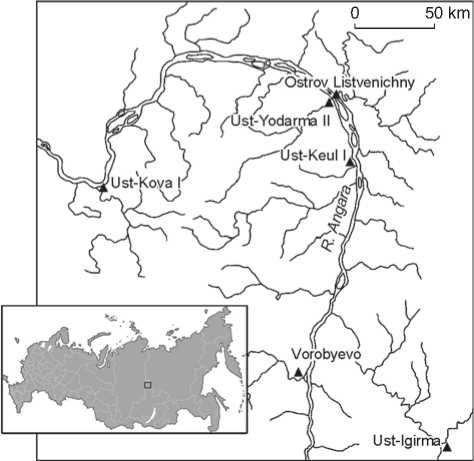
Fig. 1 . Early Holocene localities of the northern Angara region where evidence of fishery was recorded.
The methodological component of research involves analysis of the ichthyofauna remains, the composition of fishing gear, planigraphic distribution of fishery traces within the site, and correlation of the obtained data between each other and with the materials from the southern Angara region and the western coast of Lake Baikal. It should be noted that the previous results of the ichthyofauna composition analysis were subjected to some correction due to the more detailed handling of the collections.
Materials
Ostrov Listvenichny. It was located halfway between the Kata and Yodarma river mouths. The valleys of these rivers, the right and left tributaries of the Angara, respectively, are actually located opposite one another, thus forming the Kata-Yodarma expansion. This place was located in the upper part of the island, in two points: in the upstream part, and 0.5 km downstream, at the right bank, facing the Kata channel.
Point 1 (in the upper part) was a gently sloping island terrace, with the distribution area of finds approximately 150 m 2 , located in the immediate vicinity of a pronounced natural levee 2.0–2.5 m high. At the time of excavations, the distance from the river’s surface to the top of the levee was approximately 7 m. Judging by data from microstratigraphy, the ancient habitation surface was a platform, slightly inclined towards the coastline.
The Early Holocene cultural layer (layer 2) is recorded in deposits underlying the Holocene optimum series and represented by grayish-brown light silted loam, with inclusions of small pebbles. It included two microhorizons of occurrence of archaeological remains, partially separated by a sterile interlayer. According to the stratigraphic position and data from radiocarbon dating, the age of the layer is approximately 9 thousand years (Kuznetsov, Rogovskoi, 2019: 182).
The majority of faunal materials from this layer involve remains of ichthyofauna (79 % of all finds identifiable by specimens), while the relationship between these and other bone remains, including unidentifiable ones, is identical in both microhorizons (50.8 % and 50.9 %, respectively) (Ibid.: 183, 186). 277 pieces have been recorded. The majority are represented by such species as sturgeon and sterlet Acipenser (16 %), pike Esox lucius (13 %), and burbot Lota lota (59 %). The share of taimen Hucho taimen , cisco Coregonus lavaretus pidschian , roach Rutilus rutilus lacustris , ide Leuciscus idus , dace Leuciscus leuciscus baicalensis , and perch Perca fluviatilis varies from 1 % to 5 % (Mamontov, Rogovskoi, 2013: 26, tab.). In terms of planigraphy, the remains of ichthyofauna are localized around and inside fireplaces, thus forming the increased concentration zones, with various shares of finds (Kuznetsov, Rogovskoi, 2019: 185–186).
Fishing gear is represented by the only composite fish hook*. Though its wand and needle were found in different microhorizons, application provides a metrically consistent complete tool. In terms of planigraphy, artifacts also tend towards fireplaces. The bone wand is rounded in cross-section, its ventral surface is flattened by grinding (Fig. 2, 4 ). The item’s length is 28 mm, its diameter is 5 mm. At the upper end, a head is shaped by ring-form grooves. At the lower end, a support for front attachment of the needle to the base at an angle of 25° is separated and a knobble is carved by grinding and flattening. The needle, 20 mm long, is made from a small fragment of fish bone (Fig. 2, 3 ). The point is blunted, probably as a result of use. The lower edge is curved and has a row of small parallel cut marks interpreted as a place of fastening by winding.
In point 2 (downstream), with an excavated area of about 1.2 thousand m2, six cultural layers, fitted into clear lithological horizons, were distinguished. An Early Holocene cultural layer (layer 5) was recorded in deposits aged about 8.5 ka BP, which underlie the Holocene optimum series (Kuznetsov, Rogovskoi, 2016: 92). The locality directly adjoined the bank line, and at the time of excavations was located 4.0–4.5 m away from the water edge. According to the data from microstratigraphy, the habitation surface in the Early Holocene was not too different from the modern one, and formed a flatly inclined island terrace with an abrupt cliff facing the river.
148 specimens of the ichthyofauna remains have been recorded in layer 5, while the species attribution has been established for 85 specimens. Sturgeon and sterlet Acipenser account for 59 %, pike Esox lucius for 26 %, burbot Lota lota for 8 %, perch Perca fluviatilis for 6 %, and nelma Stenodus leucichthys nelma for 1 % of the total (Mamontov, Rogovskoi, 2013: 26). In terms of quantity, ichthyofauna accounts for 4.5 % of the total amount of faunal remains. In the planigraphy, it forms three local accumulations in the western part of the excavated area, one of which is confined to the fireplace.
The fishing gear includes a large series of barbed points (15 spec.), a bait fish, and the wand of a composite fish hook. All points are one-sided; the barbs are incised into the body with a rounded cross-section. The artifacts are made of bone and horn. Seven items are represented by distal, medial, and distal-medial fragments. The thickness of the blade in the majority of points varies from 6 to 9 mm, its width from 14 to 19 mm. Only one fragment of the distal portion of an item with the blade 3 mm thick and 6 mm wide stands out from the overall picture. Six artifacts are proximal and proximal-medial fragments of various states of preservation. A haft element is sharpened in all cases, suboval along the outline, with an asymmetric U- and M-shaped side recess located both immediately under the first barb (1 spec.) and in the medial (2 spec.) or distal (1 spec.) portion of the base. It is incised into the body of the base at an angle of approximately 80–90°. The length of haft element in two artifacts in a good state of preservation is 44 mm. The maximum width of the haft element is 8–11 mm.
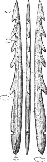
Two intact tips deserve a more detailed description. One of these is the largest one in the collection (Fig. 3). Its length is 258 mm, the maximum width is 22 m, and the thickness is 8 mm. It is made from an ungulate’s metapodium. The point was carefully ground on both sides; one of them has a longitudinal flute, a special feature of the blank material. There are five barbs: their pitch is 23–25 mm in the medial portion and 45 mm (one barb) in the distal portion. The base, 107 mm long, has a sharpened suboval contour. An M-shaped side recess incised into the body of the point at an angle of about 80° is located in its distal portion, at a distance of 36 mm from the end point.
Another barbed point stands out from the general series by its morphology (see Fig. 2, 1 ). It is also treated by grinding and has a flute (a special feature of the blank material) on one side. Five barbs are incised into the point body at an angle of 70°, while in other tools this angle is
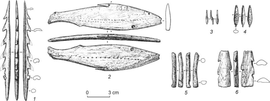
Fig. 2 . Fishery tools.
1 – 5 – Ostrov Listvenichny: 1 , 2 , 5 – point 2 (layer 5), 3 , 4 – point 1 (layer 2); 6 – Ust-Yodarma II (layer 9).
40–50°. Besides, the needle of this item is additionally sharpened. While in other points its contour on the side of barbs is straight, in this case it is concave. The base has, not a recess, but a U-shaped projection. The haft element is rounded in cross-section and sharpened. The item’s length is 129 mm, its maximum width 10 mm, and its thickness 5 mm.
Judging from the presence of such morphological features as the small number of large barbs, the profile curved in two planes, and sharpened haft elements, the items presumably pertain to the harpoon type of tool, which means the specific modus operandi of an artifact, i.e. the fish holding function (Petillon, 2008: 77). A distal location of the M-shaped recess in the first point, in combination with a large size of the item, suggests that it was secured either directly to a shaft or through an adapter using a flexible line. In case of rigid fastening (a variety of leister), the point with such a length and thickness could be broken on impact owing to linear dynamic load.
The bait fish (see Fig. 2, 2 ) is made from a tubular bone of a large mammal by means of double-side grinding. Its body has an elongated shape. Its morphology is characterized by continuity of contours profiling the back and belly of the fish, transition to the tail by gradual narrowing of the body followed by expansion at the place of the tail fin (which is partially broken off). The head is sharpened at an angle of 35°. The dorsal fin is carefully made with a narrow, deep, oblique incision, and has a hole in the middle; a small protrusion in the lower portion of figurine near the tail most probably renders the proctal fin. An eye in the form of small (not more than 1.5 mm in diameter) well is shaped on one side of the item. A circular biconical through hole, presumably intended to secure an imitator of a branchial fin, is located on the ventral portion, near the head. Dashed lines extend from the snout to the tail on the figurine; on
0 3 cm
Fig. 3 . Barbed point. Ostrov Listvenichny, point 2 (layer 5).
one side, they are depicted in two rows. These probably imitate a side line of whitefish species. In cross-section, the sculpture has a profile curved in two planes, which follows the shape of the blank (a tubular bone) and likely ensures floating in an aquatic environment, i.e. imitation of fish behavior. The figurine is 145 mm long, 33 mm wide, and about 6.6 mm thick.
The wand of a composite fish hook is a slightly curved bone cylinder, round in cross-section (see Fig. 2, 5 ). Judging by the remaining surface, the tool was given its final shape by grinding. The proximal segment is broken off. The distal end has a shallow (1 mm) groove 6 mm wide, positioned at an acute angle to the longitudinal axis of the item. This is probably the place of lateral fastening of the fish hook needle to the wand. The item’s length is 45 mm, its diameter is 6 mm.
In terms of planigraphy, the majority of barbed points (9 out of 15 spec.) were concentrated in the southeastern sector of the site, in the “recreational” zone (Kuznetsov, Rogovskoi, 2016: 93), wherein they were not confined to fireplaces or accumulations. Two points were recorded as part of tool-raw deposits—compact structurally organized accumulations of artifacts (Rogovskoi, Kuznetsov, 2014). Other tools were scattered over the site area. The bait fish was in the “recreational” zone too. An accumulation of ichthyofauna remains and fragments of three barbed points were 1.0–1.5 m away from it. A fish hook wand was found in the coastal northeastern part of the site, in the “utility” zone (Kuznetsov, Rogovskoi, 2016: 93). Scarce remains of ichthyofauna and a fragment of a barbed point were found within the radius of 2 m from it.
Ust-Yodarma II. This stratified locality is part of the ensemble of archaeological sites in the mouth of the Yodarma River (the left tributary of the Angara). The ensemble includes closely-adjacent, partially interoverlapping non-contemporaneous sites localized along the left and right banks of the river (Boguchanskaya arkheologicheskaya ekspeditsiya, 2015: 385–386). The site occupied the tip of the right Yodarma promontory situated near the mouth and a riparian area upstream the Angara River (the total length is about 1 thousand m), and formed a slightly sloping surface, with relative marks of 1–10 m, inclined towards the Angara (Lokhov, Rogovskoi, Dudarek, 2013: 118).
Materials of cultural layer 9 dated to about 8.2 ka BP pertain to the Early Holocene (Lipnina, Lokhov, Medvedev, 2013: 86)*. They contain abundant remains of ichthyofauna. The species attribution of 223 specimens has been identified. Sturgeons Acipenser account for 52.2 %, pike Esox lucius for 26.1 %, and burbot Lota lota for 21.7 % (Mamontov, Lokhov, 2013: 129, tab. 1). The remains of ichthyofauna make up ~32 % of faunal materials found in layer 9. In terms of planigraphy, almost all of them were represented by small accumulations confined to the fillings of rare fireplaces. The majority of bones were subjected to thermal treatment, in view of which their state of preservation was poor.
A medial fragment of a bone barbed point can be preliminarily assigned to the fishing gear (see Fig. 2, 6 ). The tool is double-sided, semi-oval in cross-section. It is treated by variously directed grinding on two sides. One of them has a narrow longitudinal flute— presumably a natural element of a blank (a tubular bone). The barbs are located asymmetrically and incised into the body at an angle of 40–50°. The width of the fragment (of the barbed portion) is 18 mm, its thickness is 7 mm. The artifact’s cross-sectional contour suggests that it is not a fragment of a finished tool, but the remains of a blank.
Ust-Keul I. A stratified locality was situated on a gently-sloping left area near the mouth of the Keul River (the left tributary of the Angara), with relative marks of 9–10 m (Novoseltseva, Sokolova, 2012: 137). The locality belongs to the ensemble of non-contemporaneous Ust-Keul (Left) sites (Boguchanskaya arkheologicheskaya ekspeditsiya, 2015: 470). The excavated area of the site is about 2.2 thous. m 2 .
According to the stratigraphy and the radiocarbon dating data, cultural layers 8–10 belong to the Early Holocene period. The age of layer 8 is about 8.3 ka BP (Klementyev, 2014: 34), and that of layer 9 about 10 ka BP. Layer 10 is dated to the period from 10,005 ± ± 190 BP (SOAN-8644) to 11,280 ± 170 BP (SOAN-8643) (Novoseltseva, Sokolova, 2012: 141, 144).
Traces of fishery in the said layers are represented only by the ichthyofauna remains; in layer 9, only one specimen was found. The sample from layer 8 consists of 181 specimens, wherein more than 70 % (128 spec.) were recorded in the utility pit. The distribution of species composition is as follows: sturgeons Acipenser 64.1 %, pike Esox lucius 17.1 %, burbot Lota lota 16 %; perch Perca fluviatilis , taimen Hucho taimen , and nelma Stenodus leucichthys nelma are from 0.55 to 1.7 %. Among 15 specimens of ichthyofauna remains from layer 10, sturgeons Acipenser account for 26.7 %, pike Esox lucius for 53.3 %, burbot Lota lota for 13.3 %, and perch Perca fluviatilis for 6.7 % (Mamontov, Novoseltseva, Sokolova, 2013: 136, tab. 1; 137, tab. 2).
In planigraphy of layer 8, which is recorded actually throughout the entire excavated area, separate zones with an increased concentration of finds, along with small accumulations, are discernible. Remains of ichthyofauna and utility pit were located in the southeastern part, closest to the water course, near the mouth part of the site. The distribution area of archaeological materials in layer 10 does not exceed 100 m 2 and is also confined to the nearmouth part. The remains of ichthyofauna were located inside and around the fireplace.
Discussion
From the analysis of ichthyofauna remains, the graphs of relationships between the recorded species have been plotted. These demonstrated two different fishing strategies (Fig. 4). The first one, combining materials from Ostrov Listvenichny, point 2 (layer 5), Ust-Keul I (layer 8), and Ust-Yodarma II (layer 9) shows a predominance of sturgeons in the composition of catches. Pike and burbot are represented in an approximately equal share. The share of perch, taimen, and nelma is 0.5–5.0 %. Such a ratio correlates sufficiently well with the data from the southern Angara region, where sturgeons also prevail in the Mesolithic horizons of the Ust-Belaya site (Medvedev, 1971: 114). In the Early Holocene, in the first-order tributary of the Angara (the Khaita River), the core of catch was formed by cisco, pike, and burbot (Mamontov, Saveliev, Igumnova, 2006: 275, tab. 2), at the Maloe More sites of Lake Baikal by perch, roach, and dace (Nomokonova, Lozey, Goryunova, 2009: 15, fig. 4A), and in the Angara by sturgeon and sterlet. Noteworthy is differentiation of the relative sizes of sturgeons: while the main part of remains in the northern Angara region belonged to individuals of 4.0–11.5 kg in weight (Mamontov, Rogovskoi, 2013: 26–27), their weight in the southern Angara region reached 20 kg on the average and up to 90 kilograms (Medvedev, 1971: 114). Obviously, in the northern Angara region, the main catch was sterlet, which is much smaller than sturgeon.
The second strategy is observed with respect to the materials of Ostrov Listvenichny, point 1 (layer 2). Here, the catches were dominated by burbot, while sturgeons and pike took the second place. In addition, bone remains of taimen, perch, cisco, roach, ide, and dace were recorded in this assemblage, whereas at other Early Holocene localities, the four last-mentioned species are absent. The data on layer 10 at Ust-Keul I, where an almost identical situation (though with a predominance of pike) is observed, can be assigned to the same strategy.
Such a relationship between the harvested species can be attributed to the seasonal annual cycles of economic activities conducted by ancient hunters and fishers. The data on Ostrov Listvenichny, point 2, represent the main seasonal model for the first-type strategy. The habitation seasonality of prehistoric humans in this area was indirectly established by the analysis of the state of dentition in four ungulates: the harvesting season lasted from September to December (Klementyev, 2014: 36). This suggests that the use of the Ostrov Listvenichny site, point 2, in the Early Holocene period was limited to the autumn-winter months. Roe antlers broken off from the skull and also discovered in the cultural layer are the only evidence pointing to another seasonality (spring-
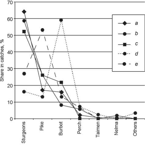
Fig. 4 . Relationship between species in the catch of the ancient population of the northern Angara region in the Early Holocene period.
a – Ust-Keul I, layer 8; b – Ostrov Listvenichny, point 2, layer 5; c – Ust-Yodarma II, layer 9; d – Ostrov Listvenichny, point 1, layer 2; e – Ust-Keul I, layer 10.
summer). Taking into account the proposed pre-winter model, this fact can be interpreted as the gathering of surface bone materials by ancient foragers. The fishing strategy of the first type only proves this model. Burbot, pike, and sturgeon were the prevailing fish species whose remains were recorded at the sites. The main biting (fish rising) of pike and burbot falls on September-October (Sabaneev, 2009: 67–68), before the beginning of winter, when these fishes lead a low-active life. By autumn, sturgeons accumulate in pits and non-freezing part of rapids (Egorov, 1943: 10).
The fishing strategy of the second type is related rather to the summer months. This is evidenced by a wide range of harvested species at Ostrov Listvenichny, point 1. Specialized fishing of sturgeon is not recorded, the composition of catches is dominated by burbot. The data on layer 10 of Ust-Keul I, despite a small size of original sample, also support the hypothesis on different seasonality.
One more interesting difference between the sites with different fishing strategies is the planigraphic situation. The area of distribution of finds in the cultural layers where the first-type strategy can be traced is large (1 thousand m 2 and more), while in the places where the second type is observed, it is rather compact (about 100–200 m 2 ) (see Table ). This situation can be related to the annual changes in the structure of foraging groups of the ancient population: they concentrated
Species composition of the ichthyofauna remains at the Early Holocene localities of the northern Angara region, %
Archaeologically recorded fishing tools at the sites where the first type of strategy has been revealed include barbed points, bait fish, and component parts of fish hooks. The functional connection between the barbed points and bait fish is described in detail and traced in numerous examples from the fishing practice of ethnographically recorded communities of hunters and fishers (Rogovskoi, Kuznetsov, 2013b: 27–28). It also indirectly confirms the pre-winter seasonal model of sites. Taking into account the Mesolithic materials from Ust-Belaya, where barbed points were also discovered, the strategy of the first type can be preliminarily attributed to fish harpooning (Medvedev, 1971: 117). Presumably, a large fish hook wand supplements the harvesting methods with the use of a self-activating trap.
Owing to its small size, the composite fish hook from Ostrov Listvenichny, point 1, is associated with catching fish with small mouth cavities (Nomokonova, Lozey, Goryunova, 2009: 17). In this case, cisco and roach recorded at the same place can be assigned to such fish. However, a wide range of represented species points to the mass harvesting of fish with the use of enclosures and traps. Thus, it can be assumed that the strategy of the second type was related to angling and setting traps.
Conclusions
The considered materials provide new information for analyzing the human ecosystem of the ancient population of Northern Asia. River fishing as part of post-glacial specialized strategy of harvesting food resources considerably extended and stabilized the food base for taiga hunter-gatherers in Baikal Siberia. The first evidence of this type of economic activity (remains of ichthyofauna and tools traditionally associated with procurement of fish) in the northern Angara region is recorded in the Early Holocene horizons of the stratified localities of Ostrov Listvenichny (points 1 and 2), Ust-Yodarma II, and Ust-Keul I. The concentration and location of these sites within the landscape can be related to the fishingindustry characteristics of the Bratsk-Ilim stretch of the Angara valley.
During the Early Holocene period, in the northern Angara region, the main targets of fishery were such species as sturgeon (Siberian sturgeon and Siberian sterlet), pike, and burbot, whereas the first-named prevailed at the majority of the described sites. Perch, taimen, nelma, and other species, judging by their share in catches, were associated yields.
The composition analysis of the ichthyofauna at the sites has revealed two different fishing strategies, apparently related to seasonality. The first was oriented towards the sturgeon breeds. The main technique was harpooning. This strategy may be associated with the periods of large-scale harvesting by the ancient population. The second strategy was oriented towards catching burbot and pike by means of angling and setting traps. It is presumably related to economic activities of smaller structural units. Thus, it can be assumed that the ancient population of the northern Angara region had a complex all-year-round system for the differentiated exploitation of fishery resources, which included various catching techniques, in the Early Holocene period (10.3–8.0 ka uncal BP).
Acknowledgement
This study was performed under Public Contract No. 33. 2057.2017/4.6 provided by the Ministry of Science and Higher Education of the Russian Federation.
